Sign explaining marine clay at the Chevron/ KMLNG Open House, in Kitimat, March 13, 2014. (Robin Rowland/Northwest Coast Energy News)
Studies on the Clio Bay reclamation project have been postponed until the fall while the new prime contractor takes over the Kitimat LNG project.
A spokesperson for Chevron said at the Kitimat LNG open house on Wednesday now that Irving , Texas-based Fluor Corp, in partnership with a joint-venture partner, Japan’s JGC Corp. has won the engineering, procurement and construction contract for the KM LNG project, it will take some time for the new company to be briefed on the Clio Bay project and then begin working with Stantec the environmental contractor on the project. That means that the reclamation project itself will now not likely proceed until spring of 2015.
In community meetings last fall, Chevron had said it expected the preliminary studies to be completed in January or February.
KM LNG, a partnership between Chevron and Apache Corp, took over the Riverlodge Recreation Centre for three days from February 2 to 4, to brief employees and contractors on the transition from KBR Inc., the original prime contractor which lost the bidding for the second stage of the contract to Flour.
KM LNG organized the open house mainly to show what is happening at the old Eurocan site, which is being converted to a work camp for the project.
The Clio Bay project, however, had a prominent place among the panels on display at Riverlodge. In the panels, Chevron says that up to 40 per cent of the Clio Bay bottom is covered with wood debris, at some points, as much as 10 metres deep, meaning a degraded habitat for dungeness crab and eel grass.
As was announced in the fall, Chevron, in partnership with the Haisla Nation, plan to take marine clay from Bish Cove and use it to cover the wood debris to create a new sea bottom. One panel said: “The new layer of marine clay is expected to be colonized by eel grass and by species such as worms, crustaceans, small fish and other sea life that will encourage a more plentiful, healthy ecosystem replacing the degraded ecosystem created by the decomposing wood debris that now covers the ocean floor.”
Chevron sees the project as an example that others could follow. Another panel notes: “Project proponents around the world are moving away from the old practice of dredging and disposing of marine clay. The Clio Bay restoration project would see marine clay used wisely to deliver benefits to the environment, community and culture.”
Work continues on the remediation of the old Eurocan mill site. Chevron and Apache are, in effect, spending millions of dollars to clean up the mess left behind when West Fraser abandoned the mill.
The company has to demolish the old mill and remediate contaminated areas. One of the big challenges is dealing with the old landfill site, which Chevron says has to be brought up to 21st century environmental standards. That includes adding an impermeable lining to the landfill and upgrading the leachate treatment systems.
Cleaning up the mess left by Eurocan will take about five years, according to one of the panels at the Open House. Chevron says that job will improve the environment, where they plan to build a work camp both in the short term and in the long term as work continues.
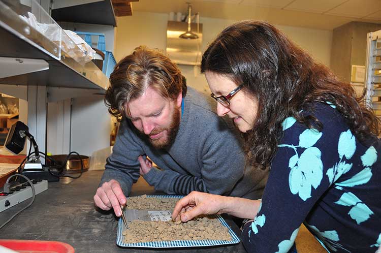
Iain McKechnie and Dana Lepofsky examine ancient herring fish bones that tell the story about how gigantic herring fisheries were for thousands of years in the Pacific Northwest. (SFU)
The herring, now dwindling on on the Pacific Coast, was once “superabundant” from Washington State through British Columbia to Alaska and that is a warning for the future, a new study says.
A team of scientists lead by Simon Fraser University argue that the archaeological record on the Pacific Coast offers a “deep time perspective” going back ten thousand years that can be a guide for future management of the herring and other fish species.
An archaeological study looked at 171 First Nations’ sites from Washington to Alaska and recovered and analyzed 435,777 fish bones from various species.
Herring bones were the most abundant and dating shows that herring abundance can be traced from about 10,700 years ago to about the mid-nineteenth century with the arrival of Europeans and the adoption of industrial harvesting methods by both settlers and some First Nations.
That means herring were perhaps the greatest food source for First Nations for ten thousand years surpassing the “iconic salmon.” Herring bones were the most frequent at 56 per cent of the sites surveyed and made up for 49 per cent of the bones at sites overall.
The study is one of many initiatives of the SFU-based Herring School, a group of researchers that investigates the cultural and ecological importance of herring.
“By compiling the largest data set of archaeological fish bones in the Pacific Northwest Coast, we demonstrate the value of using such data to establish an ecological baseline for modern fisheries,” says Iain McKechnie. The SFU archaeology postdoctoral fellow is the study’s lead author and a recent University of British Columbia graduate.
Co-author and SFU archaeology professor Dana Lepofsky states: “Our archaeological findings fit well with what First Nations have been telling us. Herring have always played a central role in the social and economic lives of coastal communities. Archaeology, combined with oral traditions, is a powerful tool for understanding coastal ecology prior to industrial development.”
The researchers drew from their ancient data-catch concrete evidence that long-ago herring populations were consistently abundant and widespread for thousands of years. This contrasts dramatically with today’s dwindling and erratic herring numbers.
“This kind of ecological baseline extends into the past well beyond the era of industrial fisheries. It is critical for understanding the ecological and cultural basis of coastal fisheries and designing sustainable management systems today,” says Ken Lertzman, another SFU co-author. The SFU School of Resource and Environmental Management professor directs the Hakai Network for Coastal People, Ecosystems and Management.
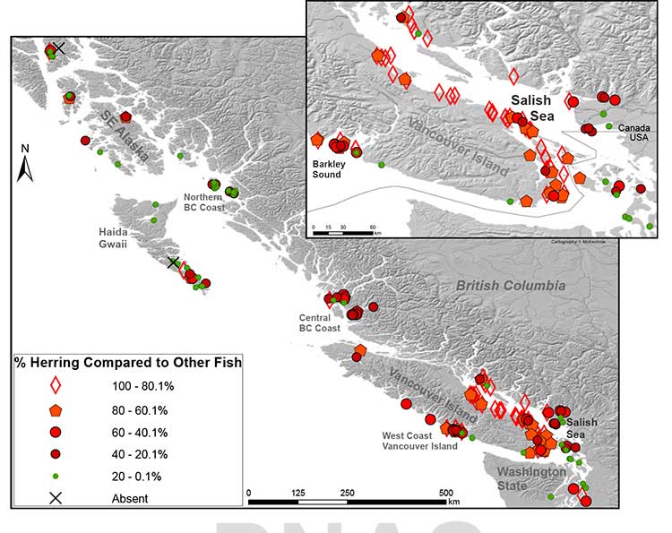
Map of First Nations’ archaeological sites with high numbers of fish bones. Herring is abundant in sites throughout the Strait of Georgia. In 71% of sites, herring makes up at least 20 per cent of the bones found at the site. (SFU/PNAS)
Heiltsuk tradition
The paper says that the abundance of herring is additionally mirrored in First Nations’ place
names and origin narratives. They give the example of the 2,400-y-old site at Nulu where herring
made up about 85 per cent of the fish found in local middens. In Heiltsuk oral tradition, it is Nulu where Raven first found herring. Another site, 25 kilometres away at the Koeye River, has only has about 10 per cent herring remains and is not associated with herring in Heiltsuk tradition.
(In an e-mail to Northwest Coast Energy News, McKechnie said “there is a paucity of archaeological data from Kitimat and Douglas Channel. There is considerable data from around Prince Rupert, the Dundas Islands and on the central coast Namu/Bella Bella/ Rivers Inlet area and in southern Haida Gwaii.”)
The study says that the archaeological record indicates that places with abundant herring were consistently harvested over time, and suggests that the areas where herring massed or spawned were more extensive and less variable in the past than today. It says that even if there were natural variations in the herring population, the First Nations harvest did not affect the species overall.
It notes:
Many coastal groups maintained family-owned locations for harvesting herring and herring roe from anchored kelp fronds, eel grass, or boughs of hemlock or cedar trees. Herring was harvested at other times of the year than the spawning period when massing in local waters but most ethnohistorical observations identify late winter and springtime spawning as a key period of harvest for both roe and fish.
The herring and herring roe were either consumed or traded among the First Nations.
Sustainable harvests encouraged by building kelp gardens,wherein some roe covered fronds were not collected, by minimizing noise and movement during spawning events, and by elaborate systems of kin-based rights and responsibilities that regulated herring use and distribution.
Industrial harvesting
Industrial harvesting and widespread consumption changed all that. Large numbers of herring were harvested to for rendering to oil or meal. By 1910, the problem was already becoming clear. In that year British Columbia prohibited the reduction of herring for oil and fertilizer. There were reports at that time that larger bays on the Lower Mainland were “being gradually deserted by the larger schools where they were formerly easily obtained.”
But harvesting continued, in 1927 the fishery on eastern Vancouver Island, Columbia, processed
31,103 tons of herring. The SFU study notes that that is roughly twice the harvest rate for 2012 and would also be about 38 per cent of the current herring biomass in the Strait of Georgia.
In Alaska, reduction of herring began in 1882 and reached a peak of 75,000 tons in 1929.
As the coastal populations dwindled, as with other fisheries, the emphasis moved to deeper water. By the 1960s, the herring populations of British Columbia and Washington had collapsed. Canada banned herring reduction entirely in 1968, Washington followed in the early 1980s.
In the 1970s, the herring population off Japan collapsed, which opened up the demand for North American roe, which targeted female herring as they were ready to spawn. That further reduced the herring population so that the roe fishery is now limited to just a few areas including parts of the Salish Sea and off Sitka and Togiak, Alaska.
The First Nations food, social and ceremonial herring fishery continues.
Government fishery managers, scientists, and local and indigenous peoples lack consensus on the cumulative consequences of ongoing commercial fisheries on herring populations. Many First Nations, Native Americans, Alaska Natives, and other local fishers, based on personal observations and traditional knowledge, hypothesize that local herring stocks, on which they consistently relied for generations, have been dramatically reduced and made more difficult to access following 20th century industrial fishing
Deep time perspective
The SFU study says that some fisheries managers are suggesting that the herring population has just shifted to other locations and other causes may be climate change and the redounding of predator populations.
But the study concludes, that:
Our data support the idea that if past populations of Pacific herring exhibited substantial variability, then this variability was expressed around a high enough mean abundance such that there was adequate herring available for indigenous fishers to sustain their harvests but avoid the extirpation of local populations.
These records thus demonstrate a fishery that was sustainable at local and regional scales over millennia, and a resilient relationship between harvesters, herring, and environmental change that has been absent in the modern era.
Archaeological data have the potential to provide a deep time perspective on the interaction between humans and the resources on which they depend.
Furthermore, the data can contribute significantly toward developing temporally meaningful ecological baselines that avoid the biases of shorter-term records.
Other universities participating in the study were the University of British Columbia, University of Oregon, Portland State University, Lakehead University, University of Toronto, Rutgers University and the University of Alberta.
Oil spills kill fish. That’s well known. Now scientists say they have found out why oil spills kill adult fish. The chemicals in the oil often trigger an irregular heartbeat and cardiac arrest.
A joint study by Stanford University and the US National Atmospheric and Oceanic Administration have discovered that crude oil interferes with fish heart cells. The toxic consequence is a slowed heart rate, reduced cardiac contractility and irregular heartbeats that can lead to cardiac arrest and sudden cardiac death.
The study was published Feb. 14, 2014 in the prestigious international journal Science and unveiled at the convention of the American Association for the Advancement of Science in Chicago.
The study is part of the ongoing Natural Resource Damage Assessment of the April 2010 Deepwater Horizon oil spill in the Gulf of Mexico.
Scientists have known for some time that crude oil is known to be “cardiotoxic” to developing fish. Until now, the mechanisms underlying the harmful effects were unclear.
Exxon Valdez
Studies going back to the Exxon Valdez oil spill in Alaska in 1989 have shown that exposure to crude oil-derived chemicals disrupt cardiac function and impairs development in larval fishes. The studies have described a syndrome of embryonic heart failure, bradycardia (slow heart beat), arrhythmias (irregular heartbeats) and edema in exposed fish embryos.
After the Gulf of Mexico spill, studies began on young fish in the aftermath of the Deepwater Horizon spill. The two science teams wanted to find out how oil specifically impacts heart cells.
Crude oil is a complex mixture of chemicals, some of which are known to be toxic to marine animals.
Past research focused on “polycyclic aromatic hydrocarbons” (PAHs), which can also be found in coal tar, creosote, air pollution and stormwater runoff from land. In the aftermath of an oil spill, the studies show PAHs can persist for many years in marine habitats and cause a variety of adverse environmental effects.
The scientists found that oil interferes with cardiac cell excitability, contraction and relaxation – vital processes for normal beat-to-beat contraction and pacing of the heart.
Low concentrations of crude
The study shows that very low concentrations of crude oil disrupt the specialized ion channel pores – where molecules flow in and out of the heart cells – that control heart rate and contraction in the cardiac muscle cell. This cyclical signalling pathway in cells throughout the heart is what propels blood out of the pump on every beat. The protein components of the signalling pathway are highly conserved in the hearts of most animals, including humans.
The researchers found that oil blocks the potassium channels distributed in heart cell membranes, increasing the time to restart the heart on every beat. This prolongs the normal cardiac action potential, and ultimately slows the heartbeat. The potassium ion channel impacted in the tuna is responsible for restarting the heart muscle cell contraction cycle after every beat, and is highly conserved throughout vertebrates, raising the possibility that animals as diverse as tuna, turtles and dolphins might be affected similarly by crude oil exposure. Oil also resulted in arrhythmias in some ventricular cells.
“The ability of a heart cell to beat depends on its capacity to move essential ions like potassium and calcium into and out of the cells quickly.” said Barbara Block, a professor of marine sciences at Stanford. She said, “We have discovered that crude oil interferes with this vital signalling process essential for our heart cells to function properly.”
Nat Scholz, leader of the Ecotoxicology Program at NOAA’s Northwest Fisheries Science Center in Seattle said.”We’ve known from NOAA research over the past two decades that crude oil is toxic to the developing hearts of fish embryos and larvae, but haven’t understood precisely why.”
Long term problems in fish hearts
He added: “These new findings more clearly define petroleum-derived chemical threats to fish and other species in coastal and ocean habitats, with implications that extend beyond oil spills to other sources of pollution such as land-based urban stormwater runoff.”
The new study also calls attention to a previously under appreciated risk to wildlife and humans, particularly from exposure to cardioactive PAHs that can also exist when there are high levels of air pollution.
“When we see these kinds of acute effects at the cardiac cell level,” Block said, “it is not surprising that chronic exposure to oil from spills such as the Deepwater Horizon can lead to long-term problems in fish hearts.”
The study used captive populations of bluefin and yellowfin tuna at the Tuna Research and Conservation Center, a collaborative facility operated by Stanford and the Monterey Bay Aquarium. That meant the research team was able to directly observe the effects of crude oil samples collected from the Gulf of Mexico on living fish heart cells.
“The protein ion channels we observe in the tuna heart cells are similar to what we would find in any vertebrate heart and provide evidence as to how petroleum products may be negatively impacting cardiac function in a wide variety of animals,” she said. “This raises the possibility that exposure to environmental PAHs in many animals – including humans – could lead to cardiac arrhythmias and bradycardia, or slowing of the heart.”
Tuna spawning
The Deepwater Horizon disaster released over 4 million barrels of crude oil during the peak spawning time for the Atlantic bluefin tuna in the spring of 2010. Electronic tagging and fisheries catch data indicate that Atlantic bluefin spawn in the area where the Deepwater Horizon drilling rig collapsed, raising the possibility that eggs and larvae, which float near the surface waters, were exposed to oil.
The spill occurred in the major spawning ground of the western Atlantic population of bluefin tuna in the Gulf of Mexico. The most recent stock assessment, conducted in 2012, estimated the spawning population of the bluefin tuna to be at only 36 percent of the 1970 baseline population. Additionally, many other pelagic fishes were also likely to have spawned in oiled habitats, including yellowfin tuna, blue marlin and swordfish.
Block and her team bathed isolated cardiac cells from the tuna in low dose crude oil concentrations similar to what fish in early life stages may have encountered in the surface waters where they were spawned after the April 2010 oil spill in the Gulf of Mexico.
They measured the heart cells’ response to record how ions flowed into and out of the heart cells to identify the specific proteins in the excitation-contraction pathway that were affected by crude oil chemical components.
Fabien Brette, a research associate in Block’s lab and lead author on the study said the scientists looked at the function of healthy heart cells in a laboratory dish and then used a microscope to measure how the cells responded when crude oil was introduced.
“The normal sequence and synchronous contraction of the heart requires rapid activation in a coordinated way of the heart cells,” Block said. “Like detectives, we dissected this process using laboratory physiological techniques to ask where oil was impacting this vital mechanism.”
The federal government’s main consultation with First Nations on the Northern Gateway Joint Review Panel report is limited to just three simple questions that had to be answered within 45 days, according to documents seen by Northwest Coast Energy News.
Cover of Volume 1 of the Joint Review Panel ruling on Northern Gateway
That despite the fact that the first volume of the JRP report “Connections” is 76 pages and the second volume “Considerations” is 418 pages including the 209 recommendations and appendices and came after two years of hearings and tens of thousands of pages of evidence.
On Dec. 6 and again on Dec. 16, 2013, just prior to the release of the Joint Review Panel report, Brett Maracle, Crown Consultation Coordinator at the Canadian Environmental Assessment Agency for the Northern Gateway project wrote to the First Nations potentially affected by Northern Gateway, saying their response had to be filed within 45 days of the release of the JRP. Since the report was released on December 19, 2013, that made the initial deadline January 31, 2014.
The letter also told the First Nations that if they wanted their positions included in the “Crown Consultation Report” that would be part of the package on Northern Gateway presented to the federal cabinet, that position had to be limited to just two to three pages “given the number of groups involved” with a final deadline of April 16, 2014.
Maracle’s letters used the term Phase IV to define the post JRP consultations, implying there were three earlier stages of consultation, something many First Nations have disputed, especially since the Harper government had earlier maintained that the JRP itself was the constitutionally mandated consultation.
The cabinet has until June 19, 2014, 180 days after the release of the report to approve the issuing of the federal permits for the Northern Gateway project. Consultation with First Nations on projects such as the Northern Gateway is required by the Constitution and has been upheld by the Supreme Court of Canada.
The three questions outlined in the letter were:
Does the Report appropriately character the concerns you raised during the JRP process?
Do the recommendations and conditions in the Panel Report address some/all of your concerns?
Are there any “outstanding” concerns that are not addressed in the Panel Report? If so, do you have recommendations (i.e proposed accommodation measures) how to address them?
Consultation on implementation
The third question appears to confirm what most political observers have said, approval of the Northern Gateway by the Harper cabinet is a a forgone conclusion, since Maracle speaks of “accommodation measures.” When the JRP approved the Northern Gateway project, the panel said that Enbridge’s proposed “mitigation” measures in case of a spill were adequate, something environmental groups and First Nations are now disputing in court.
It appears from the correspondence seen by Northwest Coast Energy News, that the federal government will only consider further specific consultations with First Nations after the approval of the Northern Gateway and only then on the implementation and construction process, rather than consulting on the project as a whole.
The Haisla have filed a document in response to the JRP that notes that
The Haisla Nation needs to understand Canada’s views of the role that future federal decisions might play for the proposed project. In its December 12, 2013 to Mr. Maracle, the Haisla Nation asked the federal government to provide a comprehensive list of the regulatory permits which would be issued the the federal government decision-makers in Haisla Nation Territory in the event the proposed project is approved and describe the consultation process that would occur prior to decisions being on those regulatory permits, within 45 days of the issuance of the JRP Report.
Mr. Maracle’s January 29, 2014 [reply] suggests that the only future federal decisions on the proposed project which may entail consultation are specific watercourse crossing and fish habitat destruction permits issued by Fisheries and Oceans Canada.
Whole-of-government
One of the problems reaching back to long before the Joint Review Panel hearings began is that the Harper government policy was what they called a “whole-of-government” approach in its consultations with First Nations, saying: “The Crown is open to discussing how consultation with the framework provided will be carried out.”
In their repose, the Haisla say the federal government never defined how the “whole-of-government” approach to First Nations was going to work and noted:
What Canada should have realized is that it has a very real obligation to consult with the Haisla Nation at the deepest end of the consultation spectrum that cannot be pigeon-holed into a one size fits all approach.
Further, the term whole-of-government is misleading, as this approach actually prohibits the majority of government from engaging in consultation.
The Haisla then say: “Documents we have obtained under an Access to Information Request clearly indicate individual departments were asked not to communicate directly with the Haisla Nation.”
The response goes on to say:
Further questions at federal government witnesses during the JRP process confirmed that federal departments had not met with the Haisla Nation since the commencement of the JRP process. While these witnesses were reluctant to confirm that they had been prohibited from meeting with us, they repeatedly referred to the “whole-of-government” approach to consultation as their reason for not meeting.
Canada’s “whole-of-government” approach clearly limited engagement to a strict process with no opportunity for real engagement.
Earliest stages
The Haisla are telling the Harper government:
It is clear that the Haisla Nation that we are the very earliest stages of consultation with Canada about the proposed project….It is clear to the Haisla Nation that the 45-day period within which Canada has unilaterally determined face-to-face meetings with all the Aboriginal groups potentially affected by the proposed project will occur is not an adequate amount of time to complete a meaningful consultation process.
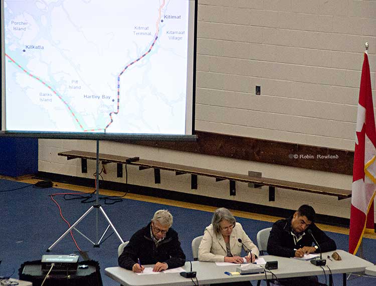
Members of the Northern Gateway Joint Review Panel, left to right, Kenneth Bateman, chair Sheila Leggett and Hans Matthews make notes at the June 25, 2012 hearings at the Haisla Recreation Centre, Kitamaat Village. A map of Douglas Channel can be seen behind the panel. (Robin Rowland/Northwest Coast Energy News)
The Haisla Nation in their response to the Crown on the Northern Gateway Joint Review Panel details four studies, three Canadian and one American that were released after the Joint Review evidentiary deadline had passed, evidence that the Haisla say should be considered in any consideration of the Northern Gateway pipeline, terminal and tanker project. (The American report from the National Oceanic And Atmospheric Administration was released after the JRP final report)
JRP chair Sheila Leggett’s constant citing of rules of procedure and her stubborn refusal to consider new evidence and studies in a dynamic situation that was changing rapidly was one of the reasons that many people in the northwest said the JRP had lost credibility.
The Haisla say: “It is incumbent upon Canada to consider and discuss the information in these reports as part of a meaningful consultation process…” and then lists “key findings” that have potential impacts on aboriginal rights and title:
The West Coast Spill response for the government of British Columbia which found:
Most oil spilled into the marine environment cannot be cleaned up
There is a disconnect between planning and actual repose capability
Canada’s spill response is “far from world class.”
The Transport Canada Ship Oil Spill Preparedness and Response study:
Douglas Channel will go from low risk to high risk for pills if the project goes ahead
The study recommends preparation for a “true worst case discharge” rather than “the credible worst case discharge” as proposed by Northern Gateway
Canada needed a much more rigorous regulatory regime covering tankers.
The joint federal government technical report on the properties of bitumen from the Canadian Oil Sands:
There are uncertainties on how diluted bitumen would behave in a marine environment.
Northern Gateway did not provide adequate information about sediment levels to allow for proper study of interaction with diluted bitumen
Dispersant may not be effective.
Weathered diluted bitumen would “reach densities at which it will sink freshwater without mechanical or physical assistance.”
The US National Oceanic And Atmospheric Administration report on Transporting Alberta Oil sands:
Diluted bitumen has “significant differences from conventional crudes.’ (The JRP used conventional crude as a benchmark in its findings)
The physical properties of diluted bitumen “fluctuate based on a number of factors.
Pipeline operators may not have detailed information related to products in the pipeline at the time of a spill
There is a lack of experimental data on the weathering behaviour of oil sands product which limits the ability of spill response organizations “to understand and predict the behaviour and fate of oil sands products in freshwater, estuarine and saltwater environments.”
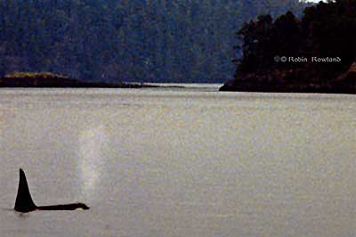
An Orca off Vancouver Island (Robin Rowland/Northwest Coast Energy News)
The worldwide population of Orcas probably crashed during the last Ice Age, creating a “bottleneck” in the genetic diversity of the species around the world, a problem that could continue to affect killer whales today, according to a new genetic study published on February 4,2014.
Rus Hoelzel from the School of Biological and Biomedical Sciences, at Durham University, in the UK and colleagues used DNA sequencing from archive material from earlier studies, or from museum specimens to track the evolution of the Orcas.
One group of Orcas that lives off South Africa are an exception, with greater genetic diversity than others, the new study has revealed.
“Killer whales have a broad world-wide distribution, rivaling that of humans. At the same time, they have very low levels of genetic diversity,” Hoelzel said.
“Our data suggest that a severe reduction in population size during the coldest period of the last ice age could help explain this low diversity, and that it could have been an event affecting populations around the world.
The Orca population along the Northwest Pacific Coast has the same low genetic diversity as in other areas, the study showed.
The killer whale is as a top predator, feeding on everything from seals to sharks. That means from the top of the food chain, the Orca also serves as a sentinel species for past and future ocean ecosystems and environmental change.
In the study published in the journal Molecular Biology and Evolution, Hoelzel and his colleagues assembled 2.23 gigabytes of Northern Hemisphere killer whale genomic data and mitochondrial DNA (mtDNA) from 616 samples worldwide.
The scientists concluded that killer whales were stable in population size during most of the Pleistocene (2.5 million – 11,000 years ago) followed by a rapid decline and bottleneck during the last great period of the Ice Age (110,000-12,000 years ago).
“Our data supports the idea of a population bottleneck affecting killer whales over a wide geographic range and leading to the loss of diversity,” Hoelzel said. “The South African population stands out as an exception, which may be due to local conditions that were productive and stable over the last million years or so.”
They are pointing to the “Benguela upwelling” ocean system which delivers nutrient rich cold water to the oceans off South Africa. The Benguela system remained stable despite the last glacial period and the nutrient rich water would have been able to sustain the supplies of fish and dolphins that killer whales in this part of the world feed on.
The scientists believe that other major upwelling systems around the world – the California current off North America; Humboldt off South America; and the Canary current off the coast of North Africa – were either disrupted or collapsed altogether during the last glacial or Pleistocene periods. This could potentially have reduced the food supply to killer whales in these areas, leading to the fall in their numbers.
While it was likely that other factors affecting killer whale populations were “overlapping and complex”, the scientists ruled out hunting as an effect on the bottleneck in populations. Hunting by early man could not have happened on a sufficient enough scale to promote the global decline in killer whale numbers.
In an e-mail to Northwest Coast Energy News, Hoelzel said that the team sequenced the DNA from a male killer whale from the Southeast Alaska resident community. “This genome revealed the same pattern of historical population dynamics as we found for a whale from the North Atlantic, suggesting shared history across a very broad geographic range, and a shared population bottleneck around the time of the last glacial maximum,” Hoelzel said.
The scientists say looking at the genetic diversity of the ocean’s other top predators, such as sharks, might potentially suggest a negative impact on their numbers too during the Ice Age.
Skeena Bulkley Valley MP Nathan Cullen says at least two of the Northern Gateway Joint Review Panel’s 209 conditions may already be outdated.
In a news release January 15, 2013, Cullen said, “The requirement of $950 million in spill insurance was recently called into question as reports surfaced of cleanup costs at the sites of Enbridge’s 2010 Michigan spill surpassing $1.035 billion.”
Cullen is referring to a study by Environment Canada Emergencies Science and Technology,Fisheries and Oceans Canada Centre for Offshore Oil, Gas and Energy Research and Natural Resoures Canada on bitumen that was completed in November and released this week.
The study found
. Like conventional crude oil, both diluted bitumen products floated on saltwater (free of sediment), even after evaporation and exposure to light and mixing with water;
. When fine sediments were suspended in the saltwater, high-energy wave action mixed the sediments with the diluted bitumen, causing the mixture to sink or be dispersed as floating tarballs;
(The use of the term “tarball” in this report follows convention in the literature and refers to the consistency of floating, heavily-weathered oil. It does not describe the chemical composition of the product.)
. Under conditions simulating breaking waves, where chemical dispersants have proven effective with conventional crude oils, a commercial chemical dispersant (Corexit 9500) had quite limited effectiveness in dispersing dilbit;
. Application of fine sediments to floating diluted bitumen was not effective in helping to disperse the products;
. The two diluted bitumen products display some of the same behaviours as conventional petroleum products (i.e. fuel oils and conventional crude oils), but also significant differences, notably for the rate and extent of evaporation.
The Panel acknowledges the variety of opinions from experts regarding the behavior and fate of oil spilled in aquatic environments. These experts generally agreed that the ultimate behavior and fate of the oil would depend on a number of factors, including the volume of oil spilled, the physical and chemical characteristics of the product, and the environmental conditions at the time.
The Panel finds that likely oil behaviour and potential response options can be predicted from knowledge of the type of oil spilled and its physical and chemical characteristics. Details of oil behaviour and response options cannot be specified until the actual circumstances of a spill are known.
The Panel is of the view that, if placed along a spectrum of: tendency to submerge; persistence; and recovery difficulty, dilbit would be on the higher end of the spectrum, similar to other heavy oil products.
The Panel accepts evidence from previous spills showing that, in response to circumstances at the time, the behaviour of heavier oils, including conventional oils and synthetic crudes, can be dynamic. Some oil floats, some sinks, and some is neutrally buoyant and subject to submergence and overwashing.
Although the project would transport different types of oil, the majority of the evidence presented during the hearing process focussed on whether dilbit is likely to sink when spilled in an aquatic environment. In light of this, the Panel has chosen to focus its views on dilbit. The Panel heard that the fate and behaviour of dilbit has not been studied as much as that of other oils.
Although there is some uncertainty regarding the behavior of dilbit spilled in water, the Panel finds that the weight of evidence indicates that dilbit is no more likely to sink to the bottom than other heavier oils with similar physical and chemical properties.
The Panel finds that dilbit is unlikely to sink due to natural weathering processes alone, within the time frame in which initial, on-water response may occur, or in the absence of sediment or other particulate matter interactions. The Panel finds that a dilbit spill is not likely to sink as a continuous layer that coats the seabed or riverbed.
“It hasn’t even been a month since the JRP released their 209 conditions, and it seems like we’re already seeing some of them become obsolete,” Cullen said.
“Throughout the review process, the JRP continually ignored the situation in Michigan as it unfolded before our eyes. They saw the spill caused by Enbridge’s negligence, which was worsened by Enbridge’s incompetence, and how it brought untold damage to the local ecosystem and cost over $1 billion US. But the 209 conditions didn’t reflect what we learned about Enbridge’s history or its culture, or what we’ve learned about diluted bitumen at all.”
The Joint Review process was set up to deliver a positive verdict, according to Cullen, regardless of what the real life case studies in Michigan had already shown. “To say that it won’t cost as much – if not more – to respond to a spill in a remote corner of northwestern BC during winter than it was in Michigan in the middle of July is ridiculous,” Cullen said.
“What’s even more astonishing is that we asked repeatedly for these studies on the behaviour of diluted bitumen in the marine environment to be part of the Joint Review Panel’s assessment. That the government waited until after the JRP had given its conditional yes to release these findings is not only appalling but also highly suspect.
Cullen says there are two key questions that the Harper government now must answer. “What kind of protection is the government providing when it lowballs on the insurance for oil spills? And what kind of oversight is it giving Canadians when the verdict is given before the evidence is released?”
(First in series of reports on how the Joint Review Panel report will affect the Kitimat region)
Joint Review map of Northern Gateway plans for dredging and blasting on Douglas Channel (JRP)
If there is a significant flaw in the Joint Review Panel report on Northern Gateway, it can be found in the panel’s analysis of Enbridge Northern Gateway’s plans to blast and dredge at the proposed Kitimat terminal site.
While the Joint Review Panel does consider what it calls “cumulative effects,” the panel plays down those effects and offers no specifics about interaction between the Northern Gateway project and the two liquified natural gas projects, the KM LNG project at Bish Cove and the BC LNG floating terminal at the old log dump.
It appears the JRP considered the legacy effects of the Rio Tinto Alcan smelter and other Kitimat industries while not taking into consideration future development.
The dredging and blasting planned by Northern Gateway, as Enbridge said in its evidence, appears to have only a minimal effect on Douglas Channel.
A glance at the map in the Joint Review ruling shows that that the dredging and blasting site is directly opposite Clio Bay, where Chevron, in partnership with the Haisla Nation, plan a remediation project using marine clay from the Bish Cove construction site to cap decades of sunken and rotting logs.
The Clio Bay project was not part of the evidence before the Joint Review Panel, the plans for the project were not formulated until well after the time for evidence before the JRP closed. But those deadlines show one area where the rules of evidence and procedure fail the people of northwestern BC.
The JRP is a snapshot in time and changes in the dynamics of the industrial development in the Kitimat Arm are not really considered beyond the terms of reference for the JRP.
It appears from the report that Enbridge plans to simply allow sediment from the blasting and dredging to float down Douglas Channel, dispersed by the currents and the outflow from the Kitimat River.
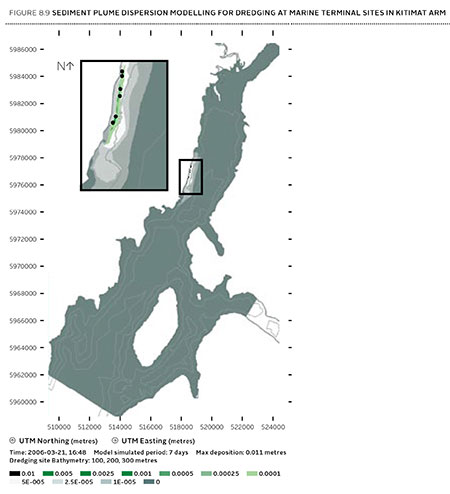
Northern Gateway said that dredging and blasting for marine terminal construction would result in a sediment plume that would extend over an area of 70,000 square metres for the duration of blasting activities.
Approximately 400 square metres of the assessed area of the marine terminal is expected to receive more than 1 centimetre of sediment deposition due to dredging. Outside of this area, typical sediment deposition levels alongshore where sediment is widely dispersed (a band approximately 4 kilometres long and 400 metres wide) are very low; in the range of 0.001 to 0.1 centimetres. Dredging and blasting activities are expected to occur over a period of approximately 18 weeks.
Northern Gateway expected most of the sediment plume created by construction activities to be minor in relation to natural background levels.
Northern Gateway would use bubble curtains to reduce pressure and acoustic effects of blasting, and silt curtains to reduce the effect of sedimentation from dredging. It said that bubble curtains are used extensively for other activities, such as pile driving, to reduce the effect of high pressure pulses that can cause injury to fish.
It added that bubble curtains have been tested extensively with blasts, and literature shows they are effective.
Northern Gateway said that physical effects from suspended sediment on marine fish and invertebrates could include abrasion and clogging of filtration mechanisms, which can interfere with ingestion and respiration. In extreme cases, effects could include smothering, burial, and mortality to fish and invertebrates. Direct chemical-related effects of suspended sediment on organisms, including reduced growth and survival, can also occur as a result of the uptake of contaminants
re-suspended by project construction activities, such as dredging and blasting, and as a result ofstorm events, tides, and currents.
The Haisla Nation and Raincoast Conservation objected to Northern Gateway’s figures, noting
Northern Gateway’s sediment and circulation model and its evidence related to contaminated sediment re-suspension at the terminal site. Both parties said that the sediment model was applied for the spring, when the increase in total suspended solids would be negligible compared to background values. In the event of delays, blasting and dredging would likely occur at other times of the year when effects would likely be higher, and these scenarios were not modelled.
The panel’s assessment of the area to be blasted found few species:
Species diversity within Kitimat Arm’s rocky intertidal community is generally low. Barnacles, mussels, periwinkles, and limpets can be found on rocky substrate. Sea urchins, moon snails, sea anemones, sea stars, and sea cucumbers are in shallow subtidal areas. Sandy areas are inhabited by commercially-harvested bivalves such as butter clams and cockles.
Northern Gateway told the JRP that it would “offset” any damage to Douglas Channel caused by the blasting and dredging
Northern Gateway said that construction, operations, and decommissioning of the marine terminal would result in both permanent and temporary alteration of marine fish habitat. Dredging and blasting, and installing physical structures in the water column for the marine terminal would permanently alter marine fish habitat. Based on the current terminal design, in-water site preparation would result in the physical alteration of approximately 1.6 hectares of subtidal marine habitat and 0.38 hectares of intertidal marine habitat. Northern Gateway expected approximately 353 square metres of subtidal marine habitat and 29 square metres of intertidal habitat to be permanently lost.This habitat would be compensated for by marine habitat offsets.
The project’s in-water vertical structures that would support the mooring and berthing structures could create new habitat, offsetting potential adverse effects. The structures may act as artificial reefs, providing marine fish habitat, food, and protection from predation. Although organisms currently inhabiting the work area would be killed, the exposed bedrock would be available for colonization as soon as the physical works are completed.
In its finding on marine sediment, the panel, as it does throughout the ruling, believes that the disruption to the environment caused by previous and ongoing human activity, means that the Northern Gateway Kitimat terminal won’t make that much difference.
Sediment quality in the marine environment is important because sediment provides habitat for benthic aquatic organisms. Northern Gateway’s baseline data for the area immediately surrounding the marine terminal indicated some contamination of water, sediments, and benthic organisms from previous industrial activity. Industrial activities in the Kitimat area have released contaminants through air emissions and effluent discharges since the 1960s. Sources of contaminants to Kitimat Arm
include effluent from a municipal wastewater treatment plant, the Alcan smelter, Methanex Corporation’s methanol plant, and the Eurocan pulpmill, as well as storm water runoff from these operations and the municipality.
Area is largely controlled by natural outflow from the Kitimat River with suspended sediment levels being highest during peak river runoff (May to July, and October) and lowest during winter. Storm events, tides, and currents can also suspend sediments. Levels of total suspended solids fluctuate seasonally and in response to climatic variations, but are generally highest during the summer.
Commercial and recreational vessels currently operating in the area may increase suspended solids by creating water turbulence that disturbs sediments. Given the current sediment contamination levels and the limited area over which sedimentation from construction activities would be expected to disperse, the Panel finds that the risk posed by disturbed contaminated sediment is low. Northern Gateway has committed to monitoring during construction to verify the predicted effects on sediment and water quality for both contaminants and total suspended solids..
The dredging and blasting section of the Joint Review Report is small when compared to the much more extensive sections on pipeline construction and tanker traffic, and the possible effects of a catastrophic oil spill.
Although minor, the marine sediment section exposes the question that was never asked, given the disruptions from years of log dumping at Clio Bay and Minette Bay and the decades of developments at the mouth of the Kitimat River, and future development from LNG, when do cumulative effects begin to overwhelm? How much is enough? How much is too much? If every project continues to be viewed in isolation, what will be left when every project is up and running?
In a news release, Rio Tinto says it is considering its future holdings in a Vancouver-based mining company named Northern Dynasty, which now is the main proponent of the copper and gold mine project. Rio Tinto “through QIT-Fer et Titane Inc., an indirect wholly-owned subsidiary of Rio Tinto plc, owns 18,145,845 common shares of Northern Dynasty, representing approximately 19.1 per cent of Northern Dynasty’s issued and outstanding shares.”
Rio Tinto says the review is part of the financially troubled conglomerate’s review of its mining holdings: “Rio Tinto will consider the Pebble Project’s fit with the Group’s strategy of investing in and operating long life and expandable assets, and with the strategy for its Copper business, which is focused on its four producing assets (Kennecott Utah Copper, Oyu Tolgoi and its interests in Escondida and Grasberg), and two development projects, La Granja in Peru and Resolution in Arizona.”
The Pebble Mine project is as controversial in Alaska and the western United States as the Northern Gateway pipeline project is in British Columbia. Critics say the proposed huge open pit copper and gold mine could endanger the Alaska headwaters of the Kvichak and Nushagak rivers, considered two of the world’s great salmon spawning grounds. Both flow into the “salmon nursery” in Bristol Bay, where young salmon go to feed, possibly also imperiling salmon stocks from both Alaska and British Columbia
New York City controller John Liu and California state controller John Chiang said their letter was prompted when Rio Tinto rival Anglo-American sold its share of the controversial project in September.
Their letter cited environmental concerns, including the fact that the project would leave 10 billion tonnes of mining waste near the salmon spawning grounds, increased regulatory scrutiny from the US Environmental Protection Agency and what the two controllers called “reputational risks” including opposition from Alaska First Nations and even jewelry companies like Tiffany & Co and Zales and Jostens. The letter cited a poll which showed 73 per cent of Americans, 84 per cent of Alaskans and 98 per cent of Bristol Bay residents opposed the project.
On December 19, the two controllers then called upon Rio Tinto to divest itself of the Northern Dynasty shares, calling, according to the Associated Press, Rio Tinto’s response “perfunctory.”
Rio Tinto spokesman David Outhwaite told AP the strategic review is not connected to that letter or a letter the financial officers sent Walsh.
Ango-American, one of Rio Tinto’s giant mining rivals, pulled out of the Pebble Mine project in September. Teck Cominco and Mitsubishi had pulled out earlier, leaving Rio Tinto as the only major company involved in the project.
When it decided to sell its share back to Northern Dynasty, Anglo-American also cited a “strategic review” of the company’s operations.
At the time, Rio Tinto’s Jennifer Ruso told the Alaska Dispatch, the company “will only participate in the project if it can be constructed, operated and closed in a manner that preserves the water, salmon, fisheries, wildlife and the environment. The project must also be developed in accordance with our strict standards for health, safety, environmental protection, cultural heritage, and community relations.”
Northern Dynasty and Rio Tinto then said they were considering an underground mine instead of an open pit operation, which did not satisfy environmental critics of the project.
On December 13, Northern Dynasty reported that it had re-acquired 100 per cent ownership of the Pebble Mine project after completing the pull out deal with Anglo-American.
The company, however, is looking for new partners. It says:
Our primary focus is to select the right partner for Northern Dynasty and the right investor for Alaska, a company with sufficient financial resources and technical capabilities, working experience in the United States and a shared commitment to environmentally sound and socially responsible development. We have little doubt that Pebble will attract major mining company interest in the months ahead.
The news release says that Northern Dynasty has spent US$556 million over the past few years and “substantial progress has been made toward our goal of permitting, constructing and operating a world-class, modern and environmentally responsible mine at Pebble that will co-exist with the fisheries resources of southwest Alaska.”
In the news release, Northern Dynasty President & CEO Ronald Thiessen said Pebble’s engineering design, environmental science and regulatory planning were advanced that the company would begin to ask for US and Alaska permitting under the National Environmental Policy Act (NEPA) sometime the first quarter of 2014.
It describes the project this way:
The Pebble Project is an initiative to responsibly develop a globally significant copper, gold and molybdenum deposit in southwest Alaska into a modern, long-life mine, which will benefit not only Northern Dynasty, but the people, culture and industries of the State of Alaska, as well as suppliers, consultants and industries in the Lower 48 United States of America.
A recent study authored by IHS Global Insight, entitled The Economic and Employment Contributions of a Conceptual Pebble Mine to the Alaska and United States Economies found the Pebble Project has the potential to support 15,000 American jobs and contribute more than $2.5 billion annually to US GDP over decades of production.
The Pebble Project is located 200 miles southwest of Anchorage on state land designated for mineral exploration and development. It is situated in a region of rolling tundra approximately 1,000 feet above sea-level, 65 miles from tidewater on Cook Inlet and presents favourable conditions for successful mine site and infrastructure development.
As the Alaska Dispatch reported when Anglo-American pulled out, the copper and gold deposits are so extensive and potentially valuable that pressure to develop the mine will continue despite the threat to salmon and the Alaska environment.
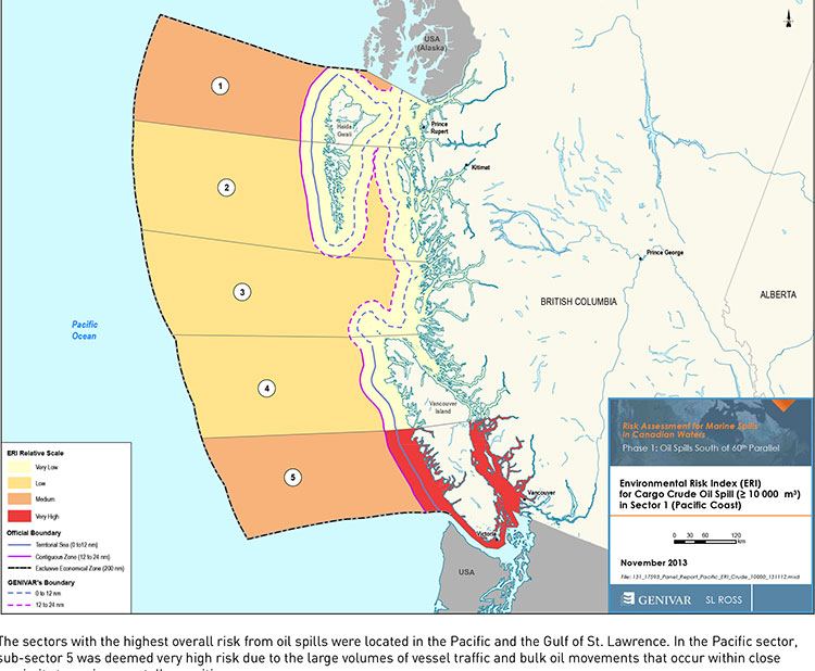
Transport Canada tanker report map shows current risk for spills in BC (Transport Canada)
Cover of Genivar tanker report (Transport Canada)
The possible effects of a bitumen spill on Pacific waters were not considered in the oil response preparedness report released last week by the Harper government, the background data study reveals.
The consulting firm that did the study for Transport Canada, Genivar Inc, had no reliable data on the effect of a bitumen tanker disaster—because, so far, there has been no major ocean disaster involving diluted bitumen.
Instead, Genivar, based its findings on potential hazards and response on existing data on crude oil spills.
The Genivar study, however, does warn, that if the Enbridge Northern Gateway project does go ahead, the spill risk from diluted bitumen carrying tankers in Douglas Channel and along the north Pacific coast will jump from “low” or “medium” to “very high.” If the twinning of the Kinder Morgan pipeline goes ahead, then the risk in Vancouver also jumps to “very high.”
The question of how bitumen might behave in the cold and choppy waters of the North Pacific was hotly debated during the Northern Gateway Joint Review hearings earlier this year. Enbridge Northern Gateway based its position on laboratory studies, studies that were challenged by environmental and First Nations intervenors, pointing both to the unknowns of the ocean environment and the continuing problems Enbridge has in cleaning up the spill in the Kalamazoo River in Michigan.
The Genivar report, Risk Assessment for Marine Spills in Canadian Waters Phase 1: Oil Spills South of 60th Parallel, was completed in November, then passed on to the “expert panel” that released their own report: A Review of Canada’s Ship-source Oil Spill Preparedness and Response Regime — Setting the Course for the Future. That second report was based not only on the data provided by Genivar but on the expertise of three panel members, their visits to some locations and input from government, industry, First Nations and municipalities.
The actual data report was not posted; it had to be requested through the Transport Canada website, which is how Northwest Coast Energy News obtained the background study.
The expert panel found “a very high risk” of oil spills in two areas of the Pacific Coast, in the north around the ports of Kitimat and Prince Rupert and in the heavy ocean traffic area of southern British Columbia, especially Port Metro Vancouver and into Washington State.
The expert panel made 45 recommendations that covered a wide range of issues including eliminating the present $161-million liability limit for each spill and replacing it with unlimited liability for polluters, annual spill training involving the Canadian Coast Guard, Environment Canada, provincial and local authorities and the private sector, increased and improved annual spill training exercises, basing risk assessment on local geography and conditions and faster emergency responses to spills.
The expert panel calls for greatly increased research on the ocean environment at a time that Harper government has been gutting environmental research across Canada, while spinning that its policies are “science based.”
The science and technology around both the movement of oil and spill response has advanced significantly over the past several decades. We feel that while some aspects of the Regime have kept pace with these developments, in some areas, Canada has fallen behind world-leading countries like Norway and France. This can be attributed to a general lack of investment in research and development as well as the lack of coordination between industry and government over research priorities.
The Government of Canada should work closely with industry to establish a national research and development program for oil spill preparedness and response. The program should be co-funded by industry and the Government, and the research priorities should be set through a collaborative process that involves academia, where possible. Like the Regime itself, we view this program as a partnership between industry and government.
We envision that this program would also seek to leverage the work being done internationally on oil spill preparedness and response. The program should seek to establish partnerships with other world-leading countries in order to stay current on international advances and new technologies.
The expert panel, however, does not say how the federal government is expected to pay for meeting BC Premier Christy Clark’s condition for a “world class” spill prevention and response system at a time that Finance Minister Jim Flaherty is determined to balance the budget and the Harper government is continuing to cut back government services.
Bitumen excluded
On bitumen, the Genivar data study says:
Modified bitumen products represent the majority of the “crude carried as cargo” in
Pacific sub-sector 5. They are not modelled as a separate category in this spill behaviour analysis but are represented as “persistent crude”.
Changes in spill behaviour depend to some extent on the environmental conditions at the time of the spill, as described in greater detail below. However, over the range of wind and sea conditions typically experienced in the Canadian marine environment, changes in oil properties are not overly sensitive to variations in climatic values, so a single set of wind and sea conditions will be used in the analysis.
The idea that “changes in oil properties” not being sensitive to variations in climate was also frequently challenged before the Joint Review Panel.
On the increase in traffic volume if the Northern Gateway project goes ahead, the Genivar report says.
Enbridge Inc. has proposed to construct a marine terminal at Kitimat, B.C. and a dual pipeline from the terminal to oil sands production in northern Alberta. The terminal would handle up to 193,000 barrels/day of imported diluents (i.e., low-gravity condensate) that would be piped to Alberta and used to dilute bitumen to enhance its flow properties. The diluted bitumen would then be piped to Kitimat at rates up to 525,000 barrels/day that would be shipped by tanker to export to markets in Asia and California.
At full capacity, the import of diluent and export of diluted bitumen would total up to 35 Mt/year. This amount is comparable to the currently-shipped volume in the Pacific sector related to volumes being exported from Vancouver and related to volumes being exported from the Alaskan to Washington State trade.
It goes on to say that the current tanker traffic on the north Pacific coast “has negligible risk in the near shore and intermediate zones, but significant potential spill frequency in the deep-sea zone related to the Alaskan trade.” Similarly, according to Genivar the environmental risk in the region “currently ranges from ‘medium’ to “very low” from near shore to deep-sea zones, respectively…. mainly driven by a combination of physical and biological features.”
The increase in traffic from Northern Gateway would likely increase the environmental risks. The the near shore risk from would jump from “very low” to “very high.” For the largest spill category, deep-sea risk would likely increase from “low” to “medium.”
No data on recreational or traditional First Nations fishery
To study the effect on an oil spill on the fishery, Genivar used data from the Department of Fisheries and Oceans as the provinces to gauge “the port value of commercial fishing and the value of the fish, shellfish and aquaculture” in each zone it studied and then compared it to the the national averages for commercial fishery. Those figures included any commercial fishery by First Nations.
But Genivar noted, there is no reliable data on either the recreational fishery or the First Nations traditional, food, social and ceremonial fishery, saying:
It is important to highlight that this indicator does not consider recreational or traditional fishing. The importance of this industry is notable and an oil spill could damage the recreational fishing stock as well. However, the absence of comparable data and the fact that this study is restricted to federal and international data, and some provincial data from Quebec and Ontario for commercial fisheries, limits the ability to include recreational fishing… Nevertheless, as an absolute index, it will provide an overall vulnerability in the event of an oil spill.
The ongoing impact of cutbacks at Fisheries and Oceans has had a continuing impact on the northwest, especially in the controversial halibut recreational fishery, where DFO has admitted that it is basically guessing the size of each year’s recreational halibut catch.
Tourism
Genivar also notes that lack of reliable data on the effect on a oil spill on tourism. The consultants go so far as to say one of the indicators they will use to measure the effect of any oil spill on tourism would come from “data extracted from the 2011 National Household Survey at the census division level and the accommodation and food services data will be used.”
The “National Household Survey” is also known as the long form census and it is the National Household Survey that the Harper government made voluntary rather mandatory, decreasing the reliability of the data. Global News recently analyzed those who had contributed to the survey and found that it poor people, the very rich and people in low population areas were least likely to fill out the voluntary census—which means the data for northwest BC is likely highly unreliable from the 2011 survey even though “The census divisions in coastal regions will be selected for each of the sub-sectors. This method will express the economic vulnerability of each sub-sector to a potential collapse in tourism following a spill.”
Despite the importance of cruise ship traffic on the west coast, Genivar notes, “In Canada, data for passenger vessels were unavailable.”
It also notes that “this study does not specifically take into account national parks and other landmarks, since their influence on tourism is indirectly included in the tourism employment
intensity index” so that Genivar could create what it calls the Human-Use Resource Index (HRI), even though that index appears to be based on incomplete data.