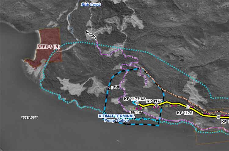
Enbridge filed a revised map of Kitimat harbour with the revised route for the Northern Gateway Pipeline and terminal in December 2012.
Enbridge Northern Gateway wants a much larger tank farm at its proposed Kitimat terminal, the company says in documents filed with the Joint Review Panel on December 28, 2012.
On that date, Enbridge filed its fifth revision of the Northern Gateway pipeline route and plans with the JRP. While for Enbridge engineers the filing may be a routine update, as surveys and planning continue, Smithers based enviromentalist Josette Weir has filed an objection with the JRP challenging the revised plans because, she says, the JRP has closed off any opportunity for intenvenors to make their own updates, calling into question once again the fairness of the JRP process.
From the documents filed with the JRP, it appears that Enbridge wants not only to expand the tank farm and adjacent areas but also to have a potentially much larger area on the shores of Douglas Channel for even more expansion in the future.
At the Kitimat terminal, Enbridge says there will now be 16 oil tanks, up from the original 11. The company also says: “The terminal site will also have some limited additional civil site development to allow for potential future site utilization.” While Enbridge proposes to keep the number of condensate tanks at three, their capacity would be increased.
In addition, Enbridge wants an enlarged “remote impoundment reservoir” to comply with the BC Fire Code, so that it would be:
• 100% of the volume of the largest tank in the tank farm, plus
• 10% of the aggregate volume of the 18 remaining tanks, plus
• an allowance for potential future tanks, plus
• 100% of the runoff from the catchment area for a 1 in 100 year, 24 hour storm event, plus
• the amount of fire water generated from potential firefighting activities at the tank farm.
Enbridge goes on to note:
An update to 16 oil tanks at the Kitimat Terminal is not expected to alter overall visibility of the marine terminal and therefore impact visual or aesthetic resources.
In her news release, Josette Wier, who describes herself as “an independent not funded intervenor in the hearing process,” says she filed a notice of motion on January 17, 2013, noting “there are numerous embedded proposed changes which have nothing to do with the route revision,” including the fact that “the tank farm in Kitimat is considerably increased from 11 to 16 tanks for the oil tanks with an almost doubled working capacity, while the condensate tanks capacity is increased by 29 per cent.”
“What does this have to do with a route revision?” she asks in the news release.
In the news release, Wier says: “that this is an abuse of process when engineering and design question period ended in Prince George last November. Not withstanding the underhanded way of presenting new evidence, re-questioning on those issues doubles the amount of work and expenses for intervenors.
“Abuse of process”
She asked the Joint Review Panel to order Northern Gateway to re-submit their proposed changes indicating clearly the ones unrelated to the route changes and describing them along with their rationale.
Wier goes on to say: “It is everyone’s guess why there is a doubling of the tank farm capacity, but certainly points out to the larger pipeline shipping volumes the company had indicated would be a possible Phase II of the project.” She says: “It looks like Northern Gateway is quietly moving into the 850,000 barrels a day proposal, twice the volume the application has been cross-examined about. It is clearly an abuse of process.”
In her actual notice of motion, Wier goes further by taking aim at the JRP itself by saying that “the Applicant [Enbridge] can make changes to the Application whenever they want. We have already seen in their July submissions inclusion of new evidence which conveniently escaped information requests. The added work and cost imposed on intervenors and the Panel seem irrelevant to the Applicant.” She complains that her requests for more information in an earlier notice of motion “was dismissed by the Panel on the grounds that my request ‘would require an unreasonable amount of effort (both by Northern Gateway and other parties reviewing the material’ …. If this argument applied to my Notice of Motion, I suggest it should apply to embedded changes buried in the Applicant’s filings of December 28, 2012.”
Rerouting at Burns Lake
A number of the other changes appear to show continued strained relations between Enbridge and First Nations, for example it says:
There is a possibility of relocating the pipeline route… further north of the Burns
Lake area to avoid proposed Indian Reserve lands that would overlap the pipeline route,.. This revision will be evaluated when further information on the proposed Indian Reserve lands is available and when further consultation with the relevant Aboriginal groups has taken place.
On the other hand the revisions also show that the pipeline will be now routed through an existing right of way through the Alexander First Nation, near Morinville, Alberta, as part of an agreement with the Alexander First Nation.
Another route change is near the Morice River, where Enbridge says
The Morice River Area alternate will generally have less effect on wildlife riparian habitat since it is located away from the Morice River and floodplain. This revision is also farther from the proposed Wildlife Habitat Area for the Telkwa caribou herd and no longer intersects any primary and secondary goat ungulate winter range polygons. However, this revision no longer parallels the Morice West Forestry Service Road (FSR) and Crystal Creek FSR and offers fewer opportunities to use existing rights-of-way. This may increase linkages between cutblock road networks and increase human access locally but does not preclude Northen Gateway from applying other methods to minimize linear feature density in this region.
Wier also complains that the Enbridge did not properly file its latest documents, asking the panel to rule that it order Northern Gateway to re-submit their last revisions submitted in December
using proper JRP evidence numbering system and “Adobe pages numbers.” The huge number of documents in the JRP system is confusing and improper filing makes it harder for intervenors and others to sort their way through new information.
A revised map of the Kitimat harbour as filed by Enbridge with the JRP in December 2012.Revised route map for the Northern Gateway pipeline as filed with Enbridge with the JRP on Dec. 28, 2012.
PetroChina went on a multi-billion dollar natural gas buying spree Thursday, Dec. 13, 2012, picking up shares in operations in both Canada and Australia.
In Canada, Encana, one of the partners in the Kitimat LNG project, signed a joint venture arrangement with Phoenix Duvernay Gas, a wholly owned subsidiary of PetroChina, to explore and develop Encana’s extensive undeveloped Duvernay naturgal gas holdings in west-central Alberta. According to an Encana news release, Phoenix will gain a non-controlling 49.9 per cent interest in Encana’s approximately 445,000 acres in the Duvernay play for total consideration of C$2.18 billion.
Hours earlier, PetroChina agreed to pay $1.63 billion for BHP Billiton’s 10 per cent share for an Australian LNG development, known as Browse, that like the KM LNG project in Kitimat had been delayed by the uncertainty in the LNG market. The other partners in the Browse are Woodside Petroleum, Chevron Corporation, Royal Dutch Shell and BP.
Encana says the PetroChina/Phoenix investment is significant for the Duvernay, which Encana describes as a “liquids rich play” with potential for natural gas, butane and oi development.
THE Encana release quotes Randy Eresman, Encana President & CEO. “A transaction of this magnitude keeps us on track to create a more diversified commodity portfolio and maintain our balance sheet strength. It is a strong endorsement of Encana’s position as a reliable long term partner.”
The release also quotes Zhiming Li, Phoenix’s President & Chief Executive Officer, as saying The Duvernay project will combine Phoenix’s integrated upstream and downstream capabilities and financial resources with Encana’s proven resource play hub expertise. This joint venture will build a foundation for the successful development of the Duvernay play and help to diversify our business portfolio. Encana is our ideal long term partner for the development of our future natural gas business.”
The company goes on to say:
Having entered into several joint venture transactions in 2012, these types of arrangements have become an important part of Encana’s business model. Joint ventures help the Company to achieve a highly efficient deployment of capital throughout its vast exploration and development asset base as Encana transitions to a more diversified portfolio of commodities.
Significantly, the Encana release, while talking about LNG development and export, it makes no mention of the Kitimat KM LNG project, instead looking south to Louisiana.
These relationships have the potential to increase natural gas demand as a number of Encana’s partners are actively exploring opportunities to export liquefied natural gas (LNG), while some are industrial consumers looking to transition to natural gas as fuel for their operations. An example is a recent agreement with Nucor Energy Holdings (Nucor) which is designed to support Nucor’s increased use of natural gas for its facilities, such as its direct reduced iron facility currently under construction in Convent, Louisiana.
Reports say PetroChina paid a premium price for the Australian Browse natural gas project, anticipating that if it comes on stream, as planned in 2018, the current glut in the natural gas market will have eased and once again LNG will be a seller’s market.
The Browse project at James Price Point on the north-western coast of Australia is facing similar opposition to projects in British Columbia, including some of the site’s aboriginal landowners and from some environmental groups.
The opposition to the Australian Browse project, according to reports, reflects a split in the local aboriginal community. While Wikipedia says that 60 per cent of the local aboriginal people voted in favour of the project, there is also fierce opposition, according to the Australian Mining Journal, which reported in 2009:
[A] number of Traditional Owners, as part of the Save The Kimberley organisation, issued a statement which said there is not unanimous support for this site.
In a signed declaration, Traditional Owners have affirmed that they do not support the imposition of an industrial site on their country and will legally challenge the authenticity of any agreements entered into by the Kimberley Land Council supporting the proposal.
The statement said that “…many local Indigenous people are disgusted by the apparent abandonment of the established process put in place by the previous State government. Concerns include the threats made earlier in the year by the Premier regarding compulsory acquisition of land and the pre-empting of the Joint State and Commonwealth environmental and cultural assessment process via announcements by Woodside and the Premier.”
A company called Woodside Petroleum, which leads the LNG venture wants to build the “greenfield” onshore terminal but is facing competition from Shell’s proposed offshore floating LNG “given the land access challenges and soaring development costs in Australia,” even though Shell also has a stake in the Browse project.
The Northern Gateway Joint Review Panel has released an updated schedule for the “Questioning Hearings” in Prince Rupert,which will cover maritime issues and for the public comment sessions in Vancouver, Victoria and Kelowna.
The comment hearings in Victoria will take place from January 3 to January 12, 2013, in Vancouver from January 14 to January 18 and January 30 to February 1, with a hearing in Kelowna on January 28.
The questioning hearings in Prince Rupert have been expanded due to demand, according to the JRP, opening on February 4, 2013, going to February 9, then from February 18 to 23, February 25 to March 5; March 11 to March 16; March 18 to March 22; April 2 to April 6; April 8 to April 12; April 22 to April 27; April 29 to May 3; May 13 to May 18.
Final arguments will begin on May 20 and continue to late June. The Joint Review Panel has not yet announced the location for final arguments. The JRP refused to hold the questioning hearings in Kitimat, but some supporters of hearings in the larger locations did support that the idea that the final arguments be held, at least in part, in Kitimat. The final arguments just be completed by June 29, according to the JRP.
The JRP will begin its deliberations in July with the final report due on December 29, 2013.
EmergencyInfoBC Please be advised that @EmergencyInfoBC is the only authorized emergency alert feed for Gov’t of BC.
Tweet Thu 8 Nov 11 48
The British Columbia Solicitor General’s department is asking northwest municipalities to “clarify the initial response actions” to the October 27 2012, magnitude 7.7 earthquake off Haida Gwaii and the resulting tsunami warning.
A covering letter to municipalities from Lori Wannamaker BC Deputy Solicitor General says the province is reviewing the response to the earthquake and tsunami and is “seeking input from affected community leaders.” The package includes a letter sent to Emergency Program Coordinators across British Columbia, adding: “Input will be sought in an endeavour to hear from those directly impacted as a measure of enhancing our operations and response,” adding. “Events like present all levels of government with a learning opportunity.”
In the main letter to the municipalities outlining emergency procedures, the department also offers a time line of its response to the incident.
Clarify the initial response actions
The package sent to municipalities by Rebecca Derlinger, Assistant Deputy Minister /Fire and Emergency Management Coordinator, opens by saying: “The earthquake/tsunami event on October 27, 2012 demonstrated the high level of emergency preparedness that has been undertaken by local governments in BC. Elected officials and emergency managers in all impacted communities deserve praise for a timely and effective response that was undertaken, including evacuations.”
But in the next paragraph the letter goes on to say: “Prior to the completion of the provincial debrief process, we would like to clarify the initial response actions of local government emergency management personnel including how information should be managed after an earthquake that impacts BC.”
The letter also says that “Local governments must complete a hazard risk and vulnerability analysis for their communities according to the Emergency Program Act and regulations, keeping in mind that all parts of British Columbia have a risk of earthquake impacts. Coastal communities have the added risk of tsunami.”
The letter then outlines three scenarios for various communities
Significant earthquake is felt in a community located in an area with tsunami risk
Earthquake is not felt, however, a community is located in an area with tsunami risk (teletsunami)
Earthquake is felt in a community that is not located in area that has tsunami risk
In all three scenarios it says Emergency Management BC “will provide the general public with ongoing situational awareness through:
EmergencyInfoBC blogsite
Social media such as Twitter
Mainstream media (press conferences and releases)
For areas such as Kitimat, which is in a possible tsunami zone, the letter advises “Local governments should undertake the following emergency response activities immediately following a significant earthquake (do not wait for official notification)
Activate their local emergency response plans and if deemed necessary
Active local first responders
Undertake public alerting and initiate evacuations of low lying areas
Open an emergency operations centre in a safe location
Report to EMBC
Ensure ongoing public messaging to their citizens
Gather information to develop situational awareness
For areas that don’t feel the earthquake, the province recommends
Local governments should undertake…emergency response activities immediately following the receipt of a West Coast Alaska Tsunami Warning Centre (or WCATTWC) and/or EMBC notification of a potential tsunami event. It then calls on local emergency officials to follow the same procedure outlined above “if a notification indicates an increased risk of a tsunami (warning or advisory only)
As you can see from the Twitter profile, Emergency Info BC works during normal office hours, Monday to Friday unless there is a declared emergency
The warnings October 27
In the letter the province outlines a time line of how the emergency system worked on October 27.
It says the provincial Tsunami Notification plan was activated at 8:10 pm. October 27, approximately four minutes after the earthquake.
In a provincial acronym soup it then says
The EMBC (Emergency Management BC) Emergency Coordination Centre initiated an internal resource request to activate the PECC (Provincial Emergency Coordination Centre) and the PREOCs (Provincial Regional Operations Centres).
EMBC and Temporary Emergency Assignment Management System (TEAMS) staff were in attendance at PECC and PREOCs by 8:33 pm.
“Based on the initial bulletin from WCATTWC, social media staff sent out a message via Twitter” at 8:48 pm At that time EMBC regional offices began contacting communities with potential tsunami risk by telephone. “Subject matter experts from Natural Resources Canada and Canadian Hydrographic Service were contacted by PECC at 8:30 pm and at 9 pm to review the information received from WCATWC.
“Based on these discussions, the PENS (Provincial Emergency Notification) was initiated at 9:05 while efforts to make contact with those communities under tsunami warning continued.
At 10:45 pm a media conference call was held by the Minister of Justice.
The letter continues to say that conference calls were held with EMBC, US state emergency management offices, and the West Coast Alaska Tsunami Warning Centre hourly until the final cancellation of the west coast warning by WCATWC at 2:47 am Sunday morning and by the province at 3:03 am
It concludes “Staff responsible for social media were actively engaged in informing the public.”
Denlinger’s letter then goes on to note that the provincial debrief will include “a discussion on the information flow from the province to emergency management stakeholders and the public (for example the use of social media as a communications tool for public awareness of the event)… This information….will assist in the creation of a provincial after action report and in the enhancement of subsequent provincial earthquake and tsunami response plans.”
At 6:06 I received an automatic text message from the West Coast Alaska Tsunami Warning Centre
Tsunami Info Stmt: M6.3 085Mi SW Port Alice, British Columbia 1802PST Nov 7: Tsunami NOT expected #WCATWC
At 6:07 I received an automatic tweet from Canadaquakes : @CANADAquakes: Automatic detection of seismic event: magnitude 4.4 – 7 Nov 18:01 PST – PORT HARDY, BC region
At 6:15, I received the WCATWC message on Twitter that I had received 9 minutes earlier via text
Tsunami Info Stmt: M6.3 085Mi SW Port Alice, British Columbia 1802PST Nov 7: Tsunami NOT expected #WCATWC
@EmergencyInfoBC retweets the WCATWC message
At 6:27 Canada quakes updated their tweet with corrected information: @CANADAquakes: EARTHQUAKE Mag=6.3 on 07 Nov at 18:01 PST. Details : http://t.co/OL9RTPKC 101 km SSW of Port Alice, BC
@EmergencyInfoBC retweets the CANADAquakes message
Analysis The province didn’t get it
Read between the lines of the Solicitor General’s letter and a couple of things stand out. While at first the officials say things went fine according to procedures in the book, events appear to show that in practice, the system didn’t work as well as expected on the night of October 27.
First the province, reminds municipalities of that they “must complete a hazard risk and vulnerability analysis for the communities.”
Second, while EM BC social media staff were, according to the letter, “were actively engaged in informing the public,” there was actually scant evidence of that during the crucial first 90 minutes after the earthquake on Haida Gwaii. While the emergency coordination officials and bureaucrats apparently were well informed about what was happening, the public was not. As I pointed out in an earlier post, differences between the US and Canadian warning systems contributed to the confusion. As well there was a problem on both Twitter and Facebook of rumour, misleading and false information being posted on social media during that crucial 90 minutes.
The line about the “the use of social media as a communications tool for public awareness of the event” is a clear indication that not all went well with the EM BC Twitter feed the night of the Haida Gwaii earthquake.
While Emergency Info BC is a sort of blog, again you have to know to go there and it is only active during an emergency. There were no posting on the night of the earthquake and tsunami. The last “blog” was during the Johnson’s Landing landslide evacuation in July 2012, and even that doesn’t give much information. Looks like Emergency Info doesn’t understand that a blog entry that says “no danger, nothing much is happening” is just as important as evacuation instructions.
The main website is Emergency Management BC, with a link to the Info site—if there is an emergency—not exactly a prime example of web design for someone in a hurry, whether an official, the media or the public, since it was what the web calls “brochure ware.”
The first indication of whether or not there would be major danger to the BC coast on Oct. 27 was at Langara Island at 9:16 pm. Local officials in northwest BC were monitoring Langara and the relatively low surge indicated–at least at that time– that danger was not as great as feared. Yet it was only seven minutes earlier that EM BC activated the Provincial Notification Program at 9:05, and that was an hour after it was known that the earthquake was 7.7 in magnitude, which had the potential for catastrophic damage. The tweets that I saw about the small surge at Langara, came from Prince Rupert. It is in a situation like the Langara monitoring that the Emergency Info blog would have been relevant.
The need for constant official updates is clear. Earthquakes do not work 8:30 to 4:30, Monday to Friday. The province has to be able to activate emergency notification much faster. If a web journalist whether working for the mainstream media or a responsible individual on a small site can tweet or post in seconds, usually working from a home office or even a smart phone, emergency officials can do the same.
In these days, travel by government officials is often frowned upon. A couple of months from now, when New York and New Jersey have recovered from the Superstorm Sandy and this weeks Nor’easter, a visit from BC emergency officials is in order to see how it is done.
Kitimat, BC and New York City had one thing in common this week, the misuse and use of social media, Twitter and Facebook, that spread both accurate warnings and dangerous misinformation about an impending disaster. In the case of New York and the surrounding area, it was Superstorm Sandy that caused widespread devastation. For Kitimat it was the tsunami warning after the 7.7 earthquake off Haida Gwaii and no damage but a lot of worry for residents.
New York has a population of millions, it is the media centre for the United States, and much of the U.S. Northeast coast is still recovering from the horrendous damage from Superstorm Sandy.
Kitimat has a population of about 8,000 and my home town is off the media radar except when the Enbridge Northern Gateway pipeline issue pops up on the national assignment desks. If the October 27, 2012 tsunami from the Haida Gwaii earthquake did come up Douglas Channel to Kitimat harbour, it was so minimal that any water rise was scarcely noticed.
In one way New York (the state and the city) plus New Jersey and other states were ahead of Kitimat. In the US, there were numerous official sources on Twitter and Facebook, as well as those ubiquitous live TV news conferences with New York Mayor Michael Bloomberg or various state governors.
On October 27, neither Kitimat nor the nearby town of Terrace had any official emergency outlets on social media. In Kitimat, that may change as early as this Monday when District Council considers what happened last Saturday night.
It has been documented that there was no official response from Emergency Management British Columbia (still largely known under its former name Provincial Emergency Program) until an hour after the first earthquake report from the US Geological Survey. Only sometime later did BC’s provincial emergency officials hold a short conference call with reporters. (At the time the BC Liberals were holding a policy convention at Whistler. After the conference call, TV reporters at the convention in Whistler were doing live reports with taped clips of Attorney General Shirley Bond. It should have been easy for Bond and other senior government officials, including Premier Christy Clark–who is plummeting the polls– to hold a live news conference just as US state governors and mayors did later in the week when it came to Superstorm Sandy)
So in that hour of silence from the BC government, one question that has to be raised is: Were the tsunami warnings so completely uncoordinated–at least as far as the public is concerned– that that was one cause of the misinformation and inaccurate information on Twitter and Facebook? Or did confusing information from authorities simply compound and amplify the social media misinformation that was already spreading across British Columbia and around the world?
Here in the northwest, the two area fire chiefs Trent Bossence of Kitimat and John Klie of Terrace have said after the quake that landline phones and some cell phones were out, in some areas up to an hour after the first shock. Klie told CFTK’s Tyler Noble on Open Connection that after the landline phones came back up the Terrace fire department was flooded with calls from people “who wanted it now.” The ability of firefighters to get information was then delayed “because so many people were trying to get through.”
Kitimat has the advantage of being a small town. Emergency services already had scheduled a volunteer recruiting session last Monday night (October 29) for Emergency Social Services–the folks who run, coordinate and work in reception centres during an emergency–so it was easy to turn that meeting into a earthquake/tsunami warning post mortem. (Imagine that happening in New York?)
The most important issue on Saturday night was the false information on both Facebook and Twitter that the Kildala neighbourhood was being evacuated due to the tsunami warning. Other false information on social media indicated that the giant Bechtel work camp at the Rio Tinto Alcan Kitimat Modernization Project was also being evacuated.
As Kitimat’s Emergency Plan Coordinator Bob McLeod told the earthquake post mortem about the information on Facebook and Twitter:
Kitimat Emergency Coordinator Bob McLeod at the earthquake postmortem Oct. 29, 2012 (Robin Rowland/Northwest Coast Energy News)
“Your aim is to be saving people, and you’re not saving people. There was one case where someone was going around banging on doors in Kildala, telling them to get out. I think it was over when he was in the lockup that night. But this is the type of foolishness that goes on. You have people going on Facebook saying ‘Alcan’s been evacuated. they’re evacuating Kildala.’ I am going to be generous and say it is misinformation… It was a blatant lie. And that does not help.”
(For those outside Kitimat you can check the town on Google maps) As seen on this screen grab, Kildala is a low lying part of town. The area north of Highway 37 is higher on a hill. Closer to the ocean at Douglas Channel are the Bechtel/RTA Kitimat Modernization Project work camps.
After driving from the village to the town, McFarlane told the meeting that he stopped at the town viewpoint where “people were telling me they had already been evacuated out of the Kildala neighbourhood, so my first stop after that was the fire department.” The fire hall is about a couple of blocks from the viewpoint, so it was easy to get accurate information from the fire department.
McFarlane continued, “I found the night of the earthquake that no information is just as bad as wrong information. People were calling me on my cell saying why does the Kitimat Daily say we have to evacuate.” That is because the Daily republished a warning from the Pacific Tsunami Warning Centre that “said tsunami warning, evacuation for the north coast. People were saying we’re on the north coast, we got to go.”
I was about fifteen to twenty minutes behind McFarlane in reaching town. (I did not leave Kitamaat Village until after we heard the first tsunami warning.) As soon as I got to back in cell range, my cell phone started to beep with saved messages from my TV and radio news clients calling for information. When I got to my home office, my landline was still dead and would be for about another twenty minutes. The only source of information at that point was Google News, Facebook and Twitter.
I saw the initial, and it turns out general, warning from the Pacific Tsunami Warning Center. Soon I was also getting what I hoped was more specific information on my marine radio from the Canadian Coast Guard Prince Rupert communications station.
But that, too was somewhat confusing. That Coast Guard advisory mentioned various zones, for example, Zone A and Zone B, but there was little specific context and that point I had no idea what Zone A meant. Prince Rupert Coast Guard Radio then went on to say evacuate low lying coastal areas. (transcript below)
With that confusion, and mindful of “when in doubt, leave it out,” I did not mention the zone system in any information I posted on Facebook and Twitter that night. I only retweeted official information or tweets from reporters I knew and trusted (and I did not see any tweeted official information from the province with a link to the page that identifies the official tsunami zones)
From the interview on CFTK, it appears that both the Kitimat and Terrace fire departments were also getting inadequate information.
“We went to our normal place to look EM BC (Emergency Management BC) and there was nothing there,so we went to Plan B to get information and went on from there,” Bossence told Tyler Noble.
Klie said: “We struggle with that every disaster big or small. Social media, I think emergency organizations are trying to tap into more and more. Up north we may be a little behind the eight ball but sure enough Twitter and Facebook information is out there instantly. Looking at Facebook with my son, I saw that they were evacuating whole cities and I knew that was not true. Because of my experience I can filter some of the information, but there is so much information out there that it’s hard to filter what’s real and not real. It’s an area where emergency coordinators have to get into because its the fastest way of getting information out.”
“Once the phone system came back online at the Fire Hall we got a flood of phone calls,” Bossence told CFTK, “it was nonstop and it was people wanting to know. ‘What’s going on? What are we going to do? Are we leaving?’ and they’re giving us ‘This is what is what I’m reading, this is what I’m being texted, on Facebook they’re saying we’re supposed to evacuate’ adding to that we had an individual going around claiming he was a fire department, he was going door to door and telling people to evacuate. That was the added issue we had to deal with. It was definitely misinformation and a sense of urgency that was coming out through the social network (and eventually the media) was big problem for us.”
In Kitimat, I was told about the man going door to door with inaccurate information and as soon as I confirmed it with reliable official sources, I posted that on both Twitter and Facebook, emphasizing there was, at that time, no evacuation order.
But every situation is different. In contrast, in Superstorm Sandy, another story about men going door to door in Williamsburg, a section of Brooklyn was not true, as can be seen in an article summing problems with Twitter in New York, where Jared Keller of Bloomberg reported
I experienced this firsthand during Hurricane Sandy. After retweeting a message warning about muggers in Williamsburg dressed as Con Ed workers as an experiment, I received two sceptical responses checking the claim within 15 minutes, both from people who work in the media industry and spend a significant amount of time on Twitter. Within an hour, I received a mass text message from friends of mine who aren’t completely plugged into the social Web with the same warning: “I just read a news alert of two separate reports of people posing as coned workers, knocking on people’s door and robbing them at gunpoint in Williamsburg. I just want to pass along the info. Stay safe and maybe don’t answer your door.” Two other friends responded with thanks.
Keller goes on to stay “I know a lot of people, especially on Facebook, who end up believing whatever they see first,” says Kate Gardiner, a social media journalist. “It’s almost impossible to track something back to its point of origin there.”
With the earthquake and tsunami warning Saturday night, Twitter misinformation spread internationally. The first hashtag I saw was #bcquake, but as the the tsunami warning gained traction (especially after the warning was extended from BC and Alaska to Washington, Oregon and California and then to Hawaii) the more common hashtag #tsunami became prominent. As people outside BC began tweeting, they began using #Canadaquake and soon #prayforcanada also began to trend. Completely inaccurate information spread on #prayforcanada (believed to have originated in Indonesia) that it was Vancouver, not the north coast that had been hit by the 7.7 magnitude earthquake.
Are you in the Zone?
At this point, one question has to be asked. The spread of information, first the well-intended but wrong, second just rumour and third, the deliberately misleading, has been seen in social media not only during the earthquake and tsunami on the West Coast last weekend, and during Superstorm Sandy on the East Coast but all the way back to the 2004 Christmas tsunami in Southeast Asia.
For the west coast in 2012, however, how much of the problem of misinformation on social media during the earthquake and tsunami warning was the fault of confusing information from the authorities? Just how were people going to interpret such general terms as “north coast” and “low lying areas.”?
From the BC Provincial Emergency Program you have to ask “What is Zone A?” It turns out by checking a day or so later that the province of British Columbia has created Tsunami Identification Zones.
Before October 27, it is likely no one outside of the provincial bureaucracy had ever heard of the provincial tsunami zones. At that time no one in BC, either on Twitter or Facebook or through the media was identifying the BC Tsunami Zones for the public. Later on, the television networks put up maps showing Zones A and B —but that was only good if you had power and were watching the right channel. Kitimat Daily and Terrace Daily posted an official update at 10:42 long after the danger was past explaining the Zone system. It was no good at all if you were listening to news reports on radio or to Prince Rupert Coast Guard Radio on a fishing boat and had no access to the actual maps.
Compounding the confusion is that the US system appears to be very different from the Canadian.
Also the US system has two levels of warning. The Pacific Tsunami Warning Center sends out general warnings but hands over for a more specific warning map from the Alaska -based West Coast and Alaska Pacific Tsunami warning centre. It uses its own system of lettered and numbered zones for the west coast of North America. (See the Oct 27 tsunami advisory here Note it is a Google maps plugin.)
Fisheries management zones as defined by the Department of Fisheries and Oceams (DFO)
So in case of a tsunami warning, Kitimat is in Zone B for the province of British Columbia and the Provincial Emergency Program and in Zone BZ921 for the West Coast and Alaska Tsunami Warning Centre. For the much more familiar fisheries management areas Kitimat is in Zone 6 (which of course has nothing to do with a tsunami, it’s simply the coastal zone system everyone is familiar with)
Adding to the confusion is the fact that the EM British Columbia map shows Terrace, far inland up the Skeena River is considered in Zone A, along with Prince Rupert for tsunami warnings (if a tsunami was big enough to reach Terrace along the Skeena River valley, then I can only assume that much of the west coast of North America would have already been wiped out).
The Monday Post mortem
At the Monday, October 29 post mortem, when McLeod outlined the events of October 27, he began by looking back three weeks, saying, “I have feeling of frustration about a couple of things. October 7, I took 4,000 brochures [How Prepared Are you if Disaster Strikes?] down to the post office to mail out to the residents of Kitimat, They were all delivered by the post office. On Sunday, I had people coming to me and saying what are we supposed to do in the case of an earthquake? It is really, really difficult to get people interested.”
McLeod said that after he felt the earthquake, he went online to check information and then went up to the fire hall, which is Kitimat’s emergency coordination centre. There he met Fire Chief Bossence, his deputy, the RCMP detachment commander Staff Sergeant Steve Corp and representatives from Bechtel and the Rio Tinto Alcan modernization project.
“For the first little while we were going on line trying to get information. The usual method of dissemination getting information it comes from the West coast and Alaska tsunami warning system, then it goes to Victoria, Victoria gives it to the geophysical specialists and they will confirm or deny what ever the information and then it goes to the Provincial Emergency Program and they shoot it out to coastal communities.
“While in this case you’re working with what you find out from different sources and you are trying to determine how reliable these sources are.”
“In our case, for me the first thing you do when you get word of an impending tidal wave [tsunami] action is check the tide. If you’re on a high tide, it’s a different situation than a low tide
“The movie version of a tidal wave is this 50 foot mountain of water roaring along and this is not what is going to happen particularly in Douglas Channel because of the depth. So you are going to see a surge such as we saw in Japan and it will be an increasing surge of water.
“We were told that potentially some sort of surge hitting Langara [the northern most island in Haida Gwaii) at 9:16, 9:16 came and went and there was no notification of a noticeable surge of water. So were down to a non event and we were on a receding tide.” (See advisory below)
“Misinformation going out is not helpful,” McLeod said. “You’ve got to set up a stream of how you get information out to people and it’s a valid point. The District Website, the Facebook page, something like that can get information out. But again if you lose power where do get it? Text can work even locally with cell phones. if you’re in a dead area with a cell phone, you can still get text”
McLeod then asked the audience, mainly people ranging from their thirties to seventies if they text. Only four or five people put up their hands. “You people are going to be saved, the rest of us…” McLeod quipped.
If a conclusion can be drawn from the earthquake and tsunami warning in the Kitimat region on October 27, it’s not just that in an emergency inaccurate, incomplete or malicious information can spread a the speed of light on social media, it’s worse that incomplete, inadequate and confusing information from the authorities is amplified and distorted by rapid posting on social media. That concept is not new for anyone who has tried the phone chain game where the outcome is often completely different from the start.
If Gardiner is correct when she says “I know a lot of people, especially on Facebook, who end up believing whatever they see first,” the BC government delays made everything worse. People Tweeted the first thing they saw and the first thing people saw came from multiple and often conflicting sources. Add that to those Tweets that were exaggeration, rumour and lies.
The problem in 2012 it is not one person talking to one person talking to one person, it is a Tweet or Facebook posting that go out to thousands, or millions of people and that’s a lot more dangerous.
McLeod said the post mortem who said emergency services is trying to get more information out to public, but he added. “The unfortunate part is that if you publish it this week, by Christmas no one will remember. If you start throwing it out every week, it becomes like a stop sign at the end of the street. Nobody sees it.”
(Coming next. If Kitimat had to evacuate)
Transcript of Prince Rupert Coast Guard Radio tsunami warning.
Pan pan. Pan pan. This is Prince Rupert Coast Guard Radio, Prince Rupert Coast Guard Radio. Warning for coastal British Columbia issued by Environment Canada on behalf of the British Columbia Provincial Emergency Program at 2057 Pacific Daylight Time Saturday 27 October. Tsunami warning for Zone A, the north coast and Haida Gwaii,Zone B, the central coast and including Bella Coola, Bella Bella and (unintelligible). A tsunami warning has been issued, if you are in a low-lying area coastal area, you are at risk and must move to higher ground or inland now.
Do not return until directed to do so. Closely monitor local radio stations for additional information from local authorities. Please minimize phone use in affected areas, for further information contact the provincial emergency program at website www. papa echo papa period bravo charlie period charlie alpha.Prince Rupert Coast Guard Radio over.
TSUNAMI BULLETIN NUMBER 003
PACIFIC TSUNAMI WARNING CENTER/NOAA/NWS
ISSUED AT 0341Z 28 OCT 2012
THIS BULLETIN APPLIES TO AREAS WITHIN AND BORDERING THE PACIFIC
OCEAN AND ADJACENT SEAS…EXCEPT ALASKA…BRITISH COLUMBIA…
WASHINGTON…OREGON AND CALIFORNIA.
… TSUNAMI INFORMATION BULLETIN …
THIS BULLETIN IS FOR INFORMATION ONLY.
THIS BULLETIN IS ISSUED AS ADVICE TO GOVERNMENT AGENCIES. ONLY
NATIONAL AND LOCAL GOVERNMENT AGENCIES HAVE THE AUTHORITY TO MAKE
DECISIONS REGARDING THE OFFICIAL STATE OF ALERT IN THEIR AREA AND
ANY ACTIONS TO BE TAKEN IN RESPONSE.
AN EARTHQUAKE HAS OCCURRED WITH THESE PRELIMINARY PARAMETERS
ORIGIN TIME – 0304Z 28 OCT 2012
COORDINATES – 52.9 NORTH 131.9 WEST
DEPTH – 10 KM
LOCATION – QUEEN CHARLOTTE ISLANDS REGION
MAGNITUDE – 7.7
EVALUATION
NO DESTRUCTIVE WIDESPREAD TSUNAMI THREAT EXISTS BASED ON
HISTORICAL EARTHQUAKE AND TSUNAMI DATA.
HOWEVER – THE WEST COAST/ALASKA TSUNAMI WARNING CENTER HAS
ISSUED A REGIONAL WARNING FOR COASTS LOCATED NEAR THE EARTHQUAKE.
THIS CENTER WILL CONTINUE TO MONITOR THE SITUATION BUT DOES NOT
EXPECT A WIDER THREAT TO OCCUR.
THIS WILL BE THE ONLY BULLETIN ISSUED FOR THIS EVENT UNLESS
ADDITIONAL INFORMATION BECOMES AVAILABLE.
THE WEST COAST/ALASKA TSUNAMI WARNING CENTER WILL ISSUE PRODUCTS
FOR ALASKA…BRITISH COLUMBIA…WASHINGTON…OREGON…CALIFORNIA.
BULLETIN
PUBLIC TSUNAMI MESSAGE NUMBER 2
NWS WEST COAST/ALASKA TSUNAMI WARNING CENTER PALMER AK
834 PM PDT SAT OCT 27 2012
THE MAGNITUDE IS UPDATED TO 7.7. THE WARNING ZONE REMAINS THE
SAME.
…THE TSUNAMI WARNING CONTINUES IN EFFECT FOR THE COASTAL
AREAS OF BRITISH COLUMBIA AND ALASKA FROM THE NORTH TIP OF
VANCOUVER ISLAND BRITISH COLUMBIA TO CAPE DECISION
ALASKA/LOCATED 85 MILES SE OF SITKA/…
…THIS MESSAGE IS INFORMATION ONLY FOR COASTAL AREAS OF
CALIFORNIA – OREGON – WASHINGTON AND BRITISH COLUMBIA FROM
THE CALIFORNIA-MEXICO BORDER TO THE NORTH TIP OF VANCOUVER
ISLAND BRITISH COLUMBIA…
…THIS MESSAGE IS INFORMATION ONLY FOR COASTAL AREAS OF
ALASKA FROM CAPE DECISION ALASKA/LOCATED 85 MILES SE OF
SITKA/ TO ATTU ALASKA…
A TSUNAMI WARNING MEANS… ALL COASTAL RESIDENTS IN THE WARNING
AREA WHO ARE NEAR THE BEACH OR IN LOW-LYING REGIONS SHOULD MOVE
IMMEDIATELY INLAND TO HIGHER GROUND AND AWAY FROM ALL HARBORS AND
INLETS INCLUDING THOSE SHELTERED DIRECTLY FROM THE SEA. THOSE
FEELING THE EARTH SHAKE… SEEING UNUSUAL WAVE ACTION… OR THE
WATER LEVEL RISING OR RECEDING MAY HAVE ONLY A FEW MINUTES BEFORE
THE TSUNAMI ARRIVAL AND SHOULD MOVE IMMEDIATELY. HOMES AND
SMALL BUILDINGS ARE NOT DESIGNED TO WITHSTAND TSUNAMI IMPACTS.
DO NOT STAY IN THESE STRUCTURES.
ALL RESIDENTS WITHIN THE WARNED AREA SHOULD BE ALERT FOR
INSTRUCTIONS BROADCAST FROM THEIR LOCAL CIVIL AUTHORITIES.
EARTHQUAKES OF THIS SIZE ARE KNOWN TO GENERATE TSUNAMIS.
AT 804 PM PACIFIC DAYLIGHT TIME ON OCTOBER 27 AN EARTHQUAKE WITH
PRELIMINARY MAGNITUDE 7.7 OCCURRED 25 MILES/40 KM SOUTH OF
SANDSPIT BRITISH COLUMBIA.
EARTHQUAKES OF THIS SIZE ARE KNOWN TO GENERATE TSUNAMIS.
IF A TSUNAMI HAS BEEN GENERATED THE WAVES WILL FIRST REACH
LANGARA ISLAND BRITISH COLUMBIA AT 916 PM PDT ON OCTOBER 27.
ESTIMATED TSUNAMI ARRIVAL TIMES AND MAPS ALONG WITH SAFETY RULES
AND OTHER INFORMATION CAN BE FOUND ON THE WEB SITE
WCATWC.ARH.NOAA.GOV.
TSUNAMIS CAN BE DANGEROUS WAVES THAT ARE NOT SURVIVABLE. WAVE
HEIGHTS ARE AMPLIFIED BY IRREGULAR SHORELINE AND ARE DIFFICULT TO
FORECAST. TSUNAMIS OFTEN APPEAR AS A STRONG SURGE AND MAY BE
PRECEDED BY A RECEDING WATER LEVEL. MARINERS IN WATER DEEPER
THAN 600 FEET SHOULD NOT BE AFFECTED BY A TSUNAMI. WAVE HEIGHTS
WILL INCREASE RAPIDLY AS WATER SHALLOWS. TSUNAMIS ARE A SERIES OF
OCEAN WAVES WHICH CAN BE DANGEROUS FOR SEVERAL HOURS AFTER THE
INITIAL WAVE ARRIVAL. DO NOT RETURN TO EVACUATED AREAS UNTIL AN
ALL CLEAR IS GIVEN BY LOCAL CIVIL AUTHORITIES.
PACIFIC COASTAL REGIONS OUTSIDE CALIFORNIA/ OREGON/ WASHINGTON/
BRITISH COLUMBIA AND ALASKA SHOULD REFER TO THE PACIFIC TSUNAMI
WARNING CENTER MESSAGES FOR INFORMATION ON THIS EVENT AT
PTWC.WEATHER.GOV.
THIS MESSAGE WILL BE UPDATED IN 30 MINUTES OR SOONER IF
THE SITUATION WARRANTS. THE TSUNAMI MESSAGE WILL REMAIN
IN EFFECT UNTIL FURTHER NOTICE. FOR FURTHER INFORMATION STAY TUNED
TO NOAA WEATHER RADIO… YOUR LOCAL TV OR RADIO STATIONS… OR SEE
THE WEB SITE WCATWC.ARH.NOAA.GOV.
$$
Did the media over react to the earthquake and tsunami warning?
There were also numerous Tweets on October 27, accusing the media of over reacting. The Haida Gwaii quake was 7.7 magnitude. Compare that to the Haiti earthquake on January 12, 2010 which was 7.0. The Christ Church, New Zealand earthquake on February 27, 2011 which caused major damage was 6.3 magnitude. So the Haida Gwaii earthquake was a major event. The tsunami warning that eventually reached as far off as Hawaii had to be taken seriously.
Fortunately Haida Gwaii is sparsely populated and there was minimal damage largely because most of the houses and buildings are wood and can absorb some of the shaking from an earthquake.
Given the tsunami damage in Southeast Asia in 2004 and in Japan in 2011, no media organization could ignore the developing story.
If there is justifiable criticism, it is that some media over hyped the story in the beginning, rather acting to reassure the public in a responsible manner. But the media that over hyped the earthquake and tsunami are the kind that would over hype any story. That is generally the result of management listening to “TV doctors” and media consultants who urge over hyping to increase ratings. (It often works). But those who, quite early in the event, who tweeted that the media was overreacting, were themselves guilty of overreaction in their Tweets.
A map from TransCanada’s Coastal GasLink showing the conceptual route of the proposed natural gas pipeline from the shale gas fields in northeastern BC through the mountains to Kitimat and the proposed Shell LNG facility. (TransCanada)
TransCanada plans a rugged over-mountain route for its proposed Coastal Gaslink pipeline to the Shell Canada liquified natural gas project in Kitimat, BC, company officials said Monday, Oct. 15, 2012, in two presentations, one to District of Kitimat Council and a second at a community town hall briefing.
The pipeline would initially carry 1.7 billion cubic feet of natural gas per day from the Montney Formation region of northeastern British Columbia along a 48 inch (1.2 metre) diameter pipe over 700 kilometres from Groundbirch, near Dawson Creek, to Kitimat, site of the proposed Shell Canada LNG Canada project.
Rick Gateman, President of Coastal GasLink Project, a wholly owned TransCanada subsidiary told council that the project is now at a “conceptual route” stage because TransCanada can’t proceed to actual planning until it has done more detailed survey work and community consultations.
At the same council meeting, documents from Shell Canada notified the District that it has formally applied to the National Energy Board for an export licence for the natural gas.
Rick Gateman, president of TransCanada’s Coastal GasLink addresses District of Kitimat Council, Oct. 15, 2012. (Robin Rowland)
Gateman told council that since the pipeline itself will be completely within the province of British Columbia, it comes under the jurisdiction of the British Columbia Environmental Assessment process and the BC Oil and Gas Commission and that the NEB will not be involved in approving the pipeline itself.
At first, the Coastal Gas Link pipeline would be connected to the existing Nova Gas Transmission system now used (and being expanded) in northeastern British Columbia.
From Vanderhoof, BC to west of Burns Lake, the Coastal GasLink pipeline would be somewhat adjacent to existing pipelines and the route of the proposed Enbridge Northern Gateway bitumen pipeline and the proposed Pacific Trails natural gas pipeline.
Somewhat south of Houston, however, the pipeline takes a different route from the either the Northern Gateway or Pacific Trails Pipeline, going southwest, avoiding the controversial Mount Nimbus route.
Howard Backus, an engineering manager with TransCanada told council that the route changes so that Coastal GasLink can avoid “congestion” in the rugged mountain region.
Backus said that the Pacific Trails Pipeline for Apache and its partners in the Kitimat LNG project “is skirting” Nimbus while Enbridge plans to tunnel through the mountain. That tunnel is one of the most controversial aspects to the Northern Gateway project. The local environmental group Douglas Channel Watch has repeatedly warned of the dangers of avalanche and geological instability in the area where the Northern Gateway pipeline emerges from the tunnel. Enbridge has challenged Douglas Channel Watch’s conclusions in papers filed with the Northern Gateway Joint Review panel.
Under TransCanada’s conceptual route, the pipeline heads southwest and then climbs into the mountains, crossing what Backus calls “a saddle” (not a pass) near the headwaters of the Kitimat River. The pipeline then comes down paralleling Hircsh Creek, emerging close to town, crossing the Kitimat River and terminating at the old Methanex plant where Shell plans its liquified natural gas plant. (That means that if the conceptual plans go ahead, the TransCanada pipeline would climb into the mountains, while Pacific Trails finds a way around and Enbridge tunnels).
Backus told council that going north “created more issues,” but did not elaborate.
Backus assured people at the town hall that energy companies have a lot of experience in building pipelines in mountainous areas, including the Andes in South America.
Asked by a local businessman at the town hall if it was possible to build a road along the route of the pipeline, Backus said the mountain areas would be too steep. Any pipeline maintenance would have to be done by tracked vehicle, he said.
Gateman told council that the pipeline would be buried along its entire route. If Shell increases the capacity of its LNG facility in Kitimat, the Coastal Gaslink pipeline could increase to 3.4 billion cubic feet a day or perhaps even more. For the initial capacity, the company will have one compressor station at the eastern end of the line. If capacity increases or if the route requires it, there could be as many as five additional compressor stations. (TransCanada’s long term planning is based on the idea that Shell will soon be adding natural gas from the rich Horn River Formation also in northeastern BC to the Kitimat export terminal.)
TransCanada will begin its field work, including route and environmental planning and “community engagement” in 2013 and file for regulatory approval in 2014. Once the project is approved, construction would begin in 2015.
Gateman said that TransCanada is consulting landowners along the proposed right of way and “on a wide area on either side.” The company also is consulting 30 First Nations along the proposed route. Gateman told council, “We probably have the most experience of any number of companies in working directly with and engaging directly with First Nations because of our pipelines across Canada.”
(Despite Gateman’s statement, the TransCanada maps showed that the Coastal Gaslink Pipeline would cross Wet’suwet’en traditional territory and officials seemed to be unaware of the ongoing problems between Apache and the Pacific Trails Pipeline and some Wet’suwet’en Houses who oppose that pipeline).
Gateman told council that the pipeline would be designed to last at least 60 years. He said that in the final test stages, the pipeline would be pressured “beyond capacity” using water rather than natural gas to try and find if any leaks developed during construction.
He said that the company would restore land disrupted by the construction of the pipeline, but noted that it would only restore “low-level vegetation.” Trees are not permitted too close to the pipeline for safety reasons.
TransCanada made the usual promises the region has heard from other companies of jobs, opportunities for local business and wide consultations. (TransCanada may have learned lessons from the botched public relations by the Enbridge Northern Gateway. A number of Kitimat residents have told Northwest Coast Energy News that TransCanada was polling in the region in mid-summer, with callers asking many specific questions about environment and the spinoffs for communities).
Councillor Phil Germuth questioned Gateman about the differences between a natural gas pipeline and a petroleum pipeline. Gateman replied that the pipelines are pretty much the same with the exception that a natural gas pipeline uses compressor stations while a petroleum pipeline uses pumping stations. Gateman did note that the original part of the controversial Keystone XL pipeline that would carry bitumen through Alberta and US mountain states to Texas was a natural gas pipeline converted to carry the heavier hydrocarbons.
Although the natural gas projects have, so far, enjoyed wide support in northwestern British Columbia, environmental groups and First Nations have raised fears that sometime in the future, especially if there is overcapacity in natural gas lines, that some may converted to bitumen, whether or not Northern Gateway is approved and actually goes ahead.
Shell application to NEB
In a fax to District of Kitimat council, Shell Canada Senior Regulatory Specialist Scot MacKillop said that the Shell had applied to the National Energy Board on September 25, 2012 for a licence to export LNG via Kitimat for the next 25 years.
The Shell proposal, like the previous Kitimat LNG and BC LNG proposals, are export applications, unlike the Enbridge Northern Gateway which is a “facility application.”
In its letter to Shell’s lawyers, the NEB took pains to head off any objections to the project on environmental or other grounds by saying:
the Board will assess whether the LNG proposed to exported does not exceed the surplus reaming after due allowance has been made for the reasonably foreseeable requirements for use in Canada. The Board cannot consider comments that are unrelated…such as those relating to potential environmental effects of the proposed exportation and any social effects that would be directly related to those environmental effects.
A new draft report for the U.S. Congress from the United States Pipeline and Hazardous Materials Safety Administration takes new aim at Enbridge for failures in its pipeline leak detection and response system.
Not that the PHMSA is singling out Enbridge, the report is highly critical of leak detection systems on all petroleum and natural gas pipeline companies, saying as far as the United States is concerned, the current pipeline standards are inadequate.
The release of the “Leak Detection Report” written by Kiefner & Associates, Inc (KAI) a consulting firm based in Worthington, Ohio, comes at a critical time, just as Enbridge was defending how it detects pipeline leaks before the Joint Review Panel questioning hearings in Prince George, where today Enbridge executives were under cross-examination by lawyers for the province of British Columbia on how the leak detection system works.
In testimony on Wednesday, October 12, Enbridge engineers told the Joint Review Panel that the company’s pipelines are world-class and have a many prevention and detection systems.
Northern Gateway president John Carruthers testifed there is no way to eliminate all the risks but the company was looking for the best way of balancing benefits against the risk.
However, the KAI report points out that so far, all pipeline company cost-benefit analysis is limited by a short term, one to five year point of view, rather than looking at the entire lifecycle of a pipeline.
Two Enbridge spills, one the well-known case in Marshall Michigan which saw bitumen go into the Kalamazoo River and a second in North Dakota, both in 2010, are at the top of the list in the study for PHMSA by the consulting firm.
The second spill, in Neche, North Dakota, which, unlike the Marshall spill, has had little attention from the media, is perhaps equally damning, because while Enbridge’s detection systems worked in that case–the KAI report calls it a “text book shutdown”– there was still a spill of 158,928 gallons (601,607 litres) of crude oil, the sixth largest hazardous liquid release reported in the United States [between 2010 and 2012] because Enbridge “did not plan adequately for containment.”
(The KAI report also examines problems with natural gas pipelines, including one by TransCanada Northern Border line at Campbell, Wyoming in February 2011. Northwest Coast Energy News will report on the natural gas aspects of the report in a future posting.)
The highly technical, 270-page draft report was released on September 28, as Enbridge was still under heavy criticism from the US National Transportation Safety Board report on the Marshall, Michigan spill and was facing penalties from the PHMSA for both the Marshall spill and a second in Ohio.
Looking at overall pipeline problem detection, KAI says the two standard industry pipeline Leak Detection Systems or LDS didn’t work very well. Between 2010 and 2012, the report found that Computational Pipeline Monitoring or CPMs caught just 20 per cent of leaks. Another system, Supervisory Control and Data Acquisition or SCADAs caught 28 per cent.
Even within those acronym systems, the KAI report says major problem is a lack of industry standards. Different companies use different detector and computer systems, control room procedures and pipeline management.
The report also concludes that the pipeline industry as a whole depends far too much on internal detectors, both for economic reasons and because that’s what the industry has always done. External detectors, the report says, have a better track record in alerting companies to spills.
A significant number of spills are also first reported by the public or first responders, rather than through the pipeline company system and as KAI says of Enbridge, “Operators should not rely on the public to tell them a pipeline has ruptured.”
The consultants also say there are far too many false alarms in spill detection systems.
Although the KAI report concentrates on the United States, its report on Enbridge does raise serious questions about how the company could detect a pipeline breach or spill in the rugged northern British Columbia wilderness where the Northern Gateway Pipeline would be built, if approved by the federal government.
The report comes after the United States Congress passed The Pipeline Safety, Regulatory Certainty, and Job Creation Act, which was signed into law by President Barack Obama on January 3, 2012. The law called on a new leak detection study to be submitted to Congress that examines the technical limitations of current leak detection systems, including the ability of the systems to detect ruptures and small leaks that are ongoing or intermittent. The act also calls on the US Department of Transportation to find out what can be done to foster development of better technologies and economically feasible ways of detecting pipeline leaks. The final report must be submitted to Congress by January 3, 2013.
(The draft report does note in some ways, Canadian standards for detecting pipeline leaks are better than those in the United States. For example, Canada requires some pipeline testing every year, the United States every five years. It also finds European pipeline monitoring regulations also surpass those in the United States).
The spills studied in the report all found weaknesses in one or more of those three areas: people, company procedures and the technology. It appears that the industry agrees, at least in principle, with executives telling the consultants:
The main identified technology gaps – including those identified by operators – include: reduction or management of false alarms; applicable technical standards and certifications; and value / performance indicators that can be applied across technologies and pipelines.
The report echoes many of the findings of the US National Transportation Safety Board in its examination of the Enbridge Marshall, Michigan spill but it applies to all pipeline companies, noting:
Integration using procedures is optimal when it is recognized that alarms from the technology are rarely black-and-white or on/off situations. Rather, at a minimum, there is a sequence: leak occurrence; followed by first detection; followed by validation or confirmation of a leak; followed by the initiation of a shutdown sequence. The length of time that this sequence should take depends on the reliability of the first detection and the severity of the consequences of the release. Procedures are critical to define this sequence carefully – with regard to the technology used, the personnel involved and the consequences – and carefully trained Personnel are needed who understand the overall system, including technologies and procedures.
We note that there is perhaps an over-emphasis of technology in LDS. A recurring theme is that of false alarms. The implication is that an LDS is expected to perform as an elementary industrial automation alarm, with an on/off state and six-sigma reliability. Any alarm that does not correspond to an actual leak is, with this thinking, an indicator of a failure of the LDS system.
Instead, multiple technical studies confirm that far more thought is required in dealing with leak alarms. Most technologies infer the potential presence of a leak via a secondary physical effect, for example an abnormal pressure or a material imbalance. These can often be due to multiple other causes apart from a leak.
The report takes a critical look at the culture of all pipeline companies which divides problems into leaks, ruptures and small seeps. Under both pipeline practice and the the way problems are reported to the PHMSA in the US a “rupture is a situation where the pipeline becomes inoperable.” While a rupture means that a greater volume of petroleum liquid or natural gas is released, and is a higher priority than a leak or seep, the use of language may mean that there is a lower priority given to those leaks and seeps than the crisis created by a rupture.
(Environmental groups in British Columbia have voiced concerns about the cumulative affect of small seeps from the Enbridge Northern Gateway that would be undetectable under heavy snow pack either by an internal system or by external observation)
Overall, the report finds serious flaws to the way pipeline companies are conducting leak detection systems at the moment, including:
Precisely the same technology, applied to two different pipelines, can have very different results.
Leak Detection Systems do not have performance measures that can be used universally across all pipelines. Compounding the problem are different computer systems where software, program configuration and parameter selection all contribute, in unpredictable ways, to overall performance.
Many performance measures present conflicting objectives. For example, leak detection systems that are highly sensitive to small amounts of lost hydrocarbons are also prone to generating more false alarms.
The performance of a leak detection system depends critically on the quality of the engineering design, care with installation, continuing maintenance and periodic testing.
Even though an internal technology may rely upon simple, basic principles, it is in fact, complex system that requires robust metering, robust SCADA and telecommunications, and a robust computer to perform the calculations. Each of these subsystems is individually complex.
Near the inlet and the outlet of the pipeline a leak leads to little or no change in pressure. Flow rates and pressures near any form of pumping or compression will generally be insensitive to a downstream leak
Differences in any one of these factors can have a dramatic impact on the ultimate value of a leak detection system.
The report goes on to say:
There is no technical reason why several different leak detection methods can not be implemented at the same time. In fact, a basic engineering robustness principle calls for at least two methods that rely on entirely separate physical principles.
The report strongly recommends that pipeline companies take a closer look at external leak detection systems. Even though the US Environmental Protection Agency began recommending the use of external detection as far back as 1988, the companies have resisted due to the cost of retrofitting the legacy pipeline network. (Of course if the pipeline companies had started retrofitting with external detectors in 1988 they would be now 24 years into the process).
KAI says:
External leak detection is both very simple – relying upon routinely installed external sensors that rely upon at most seven physical principles – and also confusing, since there is a wide range of packaging, installation options, and operational choices to be considered.
External leak detection sensors depend critically on the engineering design of their deployment and their installation.
External sensors have the potential to deliver sensitivity and time to detection far ahead of any internal system.
Most technologies can be retrofitted to existing pipelines. In general, the resistance to adopting external technologies is, nevertheless, that fieldwork on a legacy pipeline is relatively expensive.
The report goes on to identify major bureaucratic roadblocks within pipeline companies. Like many other big corporations, walls exist that prevent the system from working well
A particular organizational difficulty with leak detection is identifying who “owns” the leak detection system on a pipeline. A technical manager or engineer in charge is typically appointed, but is rarely empowered with global budgetary, manpower or strategic responsibilities. Actual ownership of this business area falls variously to metering, instrumentation and control, or IT.
The report calls for better internal standards at pipeline companies since with leak detection “one size does not necessarily fit all”.
It also notes that “flow metering is usually a central part of most internal leak detection systems,” but adds “flow meter calibration is by far the most laborious part of an internal system’s maintenance.
Also, the central computer and software technology usually has maintenance requirements far greater than most industrial automation and need special attention.”
While a company may do a cost benefit analysis of its leak detection system and risk reduction system it will generally emphasize the costs of the performance and engineering design of the leak detection system, the companies usually place less emphasis on the benefits of a robust system, especially the long term benefits.
At present the pipeline companies look at the benefit of leak detection as a reduction in risk exposure, or asset liability, “a hard, economic definition… understood by investors.” But the report adds that leak detection systems have a very long lifetime and over that life cycle, the cost-benefit approaches the reduction in asset liability caused by the system, when divided by annual operational costs. However, since pipeline companies budget on a one to five year system the long term benefit of robust, and possibly expensive spill detection is not immediately apparent.
Enbridge
The consultants studied 11 US oil spills, the top two with the greatest volume were from Enbridge pipelines. The others were from TE Products Pipeline, Dixie Pipeline, Sunoco, ExxonMobil, Shell, Amoco, Enterprise Products, Chevron and Magellan Pipeline. Not all US spills were used in the KAI report, the 11 were chosen for availability of data and documentation.
The largest spill in the KAI study was the pipeline rupture in Michigan at 843,444 gallon (3,158,714 litres) which has been the subject of continuing media, investigative and regulatory scrutiny. The second spill in North Dakota, has up to now received very little attention from the media. That will likely change once the US Congress gets the final report. Even though the Neche, North Dakota spill, has been described as “text book case” of a pipeline shutdown, there was still a large volume of oil released.
Marshall, Michigan spill
On the Marshall, Michigan spill that sent bitumen into the Kalamazoo River the report first goes over the facts of the 843,444 gallon spill and the subsequent release of a highly critical report from the US National Transportation Safety Board. It then looks at the failures of Enbridge’s detection system from the point of view mandated for the report to Congress:
The pipeline was shutting down when the ruptured occurred. Documentation indicates that a SCADA alarm did sound coincident with the most likely time of the rupture. It was dismissed. The line was shut down for around 10 hrs and crude oil would have drained from the line during this time.
On pipeline start up, alarms in the control room for the ruptured pipeline sounded. They were dismissed. This was repeated two more times. The pipeline was shut down when the control room was notified of the discharge of the crude oil by a member of the public. The time to shut down the pipeline is not relevant here because of the 17 hours that elapsed after the rupture occurred.
The review identified issues at Enbridge relevant to this Leak Detection Study:
1. Instrumentation on a pipeline that informs a controller what is happening to the pipeline must be definitive in all situations.
2. However, the instrumentation did provide warnings which went unheeded by controllers.
3. Instrumentation could be used to prevent a pump start up.
4. Operators should not rely on the public to tell them when a pipeline has ruptured.
5. Pipeline controllers need to be fully conversant with instrumentation response to different operations performed on the pipeline.
6. If alarms can be cancelled there is something wrong with the instrumentation feedback loop to the controller. This is akin to the low fuel warning on a car being turned off and ignored. The pipeline controller is part of an LDS and failure by a controller means the LDS has failed even if the instrumentation is providing correct alarms.
7. If the first SCADA alarm had been investigated, up to 10 hours of pipeline drainage to the environment might have been avoided. If the second alarm had been investigated, up to 7 hours of pumping oil at almost full capacity into the environment might have been avoided.
8. CPM systems are often either ignored or run at much higher tolerances during pipeline start ups and shutdowns, so it is probable that the CPM was inoperative or unreliable. SCADA alarms, on the other hand, should apply under most operating conditions.
Neche, North Dakota spill
At approximately 11:37 pm. local time, on January 8, 2010, a rupture occurred on Enbridge’s Line 2, resulting in the release of approximately 3000 barrels or 158,928 gallons of crude oil approximately 1.5 miles northeast of the town of Neche, North Dakota, creating the sixth largest spill in the US during the study period.
As the report notes, in this case, Enbridge’s detection system worked:
At 11:38 pm., a low-suction alarm initiated an emergency station cascade shutdown. At 11:40 pm., the Gretna station valve began closing. At 11:44 pm., the Gretna station was isolated. At 11:49 pm., Line 2 was fully isolated from the Gretna to Donaldson pump stations.
Documentation indicates a rapid shut down on a low suction alarm by the pipeline controller. From rupture to shut down is recorded as taking 4 minutes. The length of pipeline isolated by upstream and downstream remotely controlled valves was 220,862 feet. The inventory for this length of line of 26-inch diameter is 799,497 gallons. The release amount was around 20 per cent of the isolated inventory when the pipeline was shut down.
The orientation of the 50-inch long rupture in the pipe seam is not known. The terrain and elevation of the pipeline is not known. The operator took around 2 hours and 40 minutes to arrive on site. It is surmised that the rupture orientation and local terrain along with the very quick reactions by the pipeline controller may have contributed to the loss of around 20 per cent of the isolated inventory.
The controller was alerted by the SCADA. Although a CPM system was functional the time of the incident it did not play a part in detecting the release event. It did provide confirmation.
But the KAI review identified a number of issues, including the fact in item (7) Enbridge did not plan for for containment and that containment systems were “under-designed.”
1. This release is documented as a text book shut down of a pipeline based on a SCADA alarm.
2. The LDS did not play a part in alerting the pipeline controller according to
documentation. However, leak detection using Flow/Pressure Monitoring via SCADA
worked well.
3. Although a textbook shut down in 4 minutes is recorded, a large release volume still occurred.
4. The release volume of 158,928 gallons of crude oil is the sixth largest hazardous liquid release reported between January 1, 2010 and July 7, 2012.
5. The length of pipeline between upstream and downstream isolation valves is long at 41.8 miles.
6. If not already performed, the operator should review potential release volumes based on ruptures taking place at different locations on the isolated section.
7. The success of a leak detection system includes planning for the entire process: detection through shutdown through containment. In this case, the operator did not plan adequately for containment so that although the SCADA leak detection technology, the controller and the procedures worked well, the containment systems (isolation valves) were under-designed and placed to allow a very large spill.”
Rio Tinto Alcan has reopened Hospital Beach, the nearby boat ramp and Moore Creek and the Moore Creek falls for public use.
RTA took out an ad in a local newspaper Wednesday, Oct. 12, 2012, to make the announcement which came after a meeting members of the District of Kitimat Council on Oct. 4.
The RTA statement reads, in part:
Both Rio Tinto Alcan and the District of Kitimat understand the value and importance of ocean access to residents of the area while at the same time, continuing to respect and ensure that safety is the number one priority.
Over the last few months, while hearing the disappointment and concern about Hospital Beach, the KMP [Kitimat Modernization Project] Construction Team took action to mitigate the public safety risk. The massive rock trucks hauling heavy loads will be re-routed; a new bridge over Anderson Creek has been installed; new traffic lights will be installed near the Construction Village; and an extra construction road has been built from the former Eurocan Haul Road. All these measures have enabled the decision to accommodate the wishes of the community to access Hospital Beach, the boat ramp and Moore Creek safely.
It is important to remind residents however, Rio Tinto Alcan is in the middle of constructing a mega project to modernize and sustain the aluminium smelter business in Kitimat for the benefit of us all. This is the highest priority with many demands and intense focus. To that end, Rio Tinto Alcan will continue to assess traffic patterns and will likely need to make short term closures again as construction dictates. It is imperative that residents respect the company’s right to manage activities on its private property as it deems in the best interest of its business, including the KMP and public safety.
Rio Tinto Alcan and the District of Kitimat have committed together to work toward finding long term solution to ocean access. Thank you all for your patience, support and cooperation.
Prince Rupert residents wanting to walk along the road adjoining the ocean past Rotary Waterfront Park will notice new barriers and signs alerting them that they would be trespassing should they do so.
The barricades and signs were put up yesterday, and CN regional manager of public affairs Emily Hamer says it is due to safety concerns with the public on the railway’s property.
Prince Rupert acting mayor Anna Ashley told the Northern View the city expected some restrictions during construction and said the city planned to talk to CN about the issue.
In an e-mail to Northwest Coast Energy News after the October 4 meetingm Kitimat mayor Joanne Monaghan, while hinting then that a solution to the restrictions was coming, said that industry has been faced with so many lawsuits that safety is becoming a bigger issue.
Councillor Corinne Scott also said that the meeting with RTA stressed that “Large businesses are putting safety as a higher priority.” (She also noted that council agreed to have regular meetings with RTA “.communication lines are open and we look forward to a continued good working relationship between the District of Kitimat and RTA. “)
In both cases, it appears that waterfront access is a legacy issue, left over from an earlier era of industrial development that gave little thought to either the environment or community.
Now it is also apparent that liability lawyers, who probably live thousands of kilometres away from the northwest, have, so far, been driving this issue, with little regard for the needs of local residents.
Make no mistake, safety should be a high priority, but arbitrary restrictions that may look good on legal brief, could actually mean that people would simply try to get around the restrictions, to the determent of safety. It is well known that RTA Plant Protection was finding people at Hospital Beach during the summer, especially at night, despite the publicized restrictions, barriers and warning signs.
Today with a strong need for jobs in northwestern British Columbia, future community needs for access to waterfront and green space (even in such a wide green area as northern BC) must be taken into consideration in municipal and corporate planning. If that planning isn’t done, that will mean that while there could be jobs, the northwest could be in a situation as it was this summer, with no way to enjoy the advantages of waterfront life in northern BC.
The 911 system failed during the 2010 Marshall, Michigan, Enbridge pipeline breach, according to the full report in the incident released by the US National Transportation Safety Board.
The NTSB report says the 911 operators in Michigan dismissed eight calls reporting gas or petroleum odours over a period of 14 hours between the initial report of a bad odour and the actual discovery of diluted bitumen polluting Talmadge Creek.
The report also says the local firefighters were unfamiliar at that point with potential problems from a bitumen pipeline as opposed to a leak of a consumer natural gas pipeline.
Although the NTSB report puts most of the onus on an inadequate Enbridge “Public Awareness Program” (PAP) which failed to familiarize first responders to potential problems, the report raises questions whether British Columbia, especially the north, is properly prepared for all the energy development that is occurring. Whether or not the Enbridge Northern Gateway project proceeds, there are three active and possibly as many as three or four planned liquified natural gas projects for the northwest, ongoing exploration and production in the northeast and the proposed Kinder Morgan expansion in the lower mainland.
The NTSB says that Sunday, July 25, 2010, at 5:58 pm. EDT, a segment of a 30 inch (7.62 cm) diameter pipeline (Line 6B) operated by Enbridge ruptured in a wetland in Marshall, Michigan. The rupture occurred during the last stages of a pipeline shutdown planned by Enbridge. The leak was not discovered or addressed for over 17 hours, largely due to problems in the Enbridge control room in Edmonton.
During the time lapse, the NTSB says, Enbridge twice pumped additional oil (81 percent of the total release) into Line 6B during two pipeline start ups; the total release was estimated to be 843,444 gallons or 3.192 million litres of crude oil. The oil saturated the surrounding wetlands and flowed into the Talmadge Creek and the Kalamazoo River.
According to the NTSB time line, at 8:56 pm., Michigan Gas Utilities dispatched a senior service technician after residents reported a natural gas odour. At 9:25 pm. on July 25, a local resident called the Calhoun County 911 dispatch:
I was just at the airport in Marshall and drove south on Old 27 [17 Mile Road]
and drove back north again and there’s a very, very, very strong odour, either
natural gas or maybe crude oil or something, and because the wind’s coming out
of the north, you can smell it all the way up to the tanks, right across from where
the airport’s at, and then you can’t smell it anymore.
By 9:32 pm., the Marshall City Fire Department had been dispatched in response to the 9:25 pm. call to 911. The 911 dispatcher told the responders there was a report of a bad smell of natural gas near the airport. The responding firefighters were also dispatched. The firefighters checked pipelines and industrial building near the airport. “using a combustible gas indicator” to try to locate the origin of the odour, but did not detect anything.
A map from the NTSB report showing where the fire department responded to the reports of a gas smell at Marshall, MIchigan, and the location of the actual pipeline break. (NTSB)
The NTSB says the service technician from Michigan Gas Utilities “crossed paths with some of the fire department personnel” but found no evidence of a gas leak.
The fire department personnel departed the scene at 10:54 pm. to return to the station.
The NTSB report says: “ a combustible gas indicator measures percentage of the lower explosive limit, it likely would not detect the oil unless it was very close to the source.”
At 11:33 pm, the area’s 911 system received the first of the seven additional calls when an employee at a business called to report a natural gas odour.
The 911 dispatcher told the caller that the fire department had already responded
to calls in the area, and no more personnel were dispatched.
A map of the incident response by the NTSB shows that the area near the airport where the firefighters responded was actually some distance from the pipeline rupture.
Over the next 14 hours, the NTSB says, 911 received seven more calls reporting strong natural gas or petroleum odours in the same vicinity. “The 911 dispatcher repeatedly informed the callers that the fire department had been dispatched to investigate the reported odours.”
Enbridge had been working on restarting the pipeline all night. In Edmonton, at 10:16 am, the Enbridge control room spoke to the regional manager based in Chicago to send someone to
walk along the pipeline, upstream and downstream of the Marshall pumping station.
According to the NTSB, the Chicago regional manager replied, “I wouldn’t think so. If it’s right at Marshall—you know, it seems like there’s something else going wrong either with the computer or with the instrumentation. …you lost column and things go haywire, right?” He went on to say, “…I’m not convinced. We haven’t had any phone calls. I mean it’s perfect weather out here—if it’s a rupture someone’s going to notice that, you know and smell it.” The Chicago regional manager told shift lead C1 that he was okay with the control centre starting Line 6B again.
At 11:17 am, a caller from a second gas utility, Consumers Energy, called the Enbridge emergency line telling the control room: “I work for Consumers Energy[30] and I’m in Marshall. There’s oil getting into the creek and I believe it’s from your pipeline. I mean there’s a lot. We’re getting like 20 gas leak calls and everything.”
At 11:18 am Enbridge closed the remote valves sealing off the rupture site within a 2.95-mile section. By 11:20 am., the shift lead had called the Chicago regional manager to tell him about the notification. By 11:37 am., another Consumers Energy employee notified 911 about the crude oil leak in a creek near Division Drive.
The Fredonia Township Fire Department was dispatched by the 911 centre shortly after the call. At 11:41 am., the Edmonton control centre received confirmation from an Enbridge crossing coordinator located at the Marshall pipeline maintenance shop confirming the oil on the ground.
The NTSB says:
The 911 operators repeatedly informed the callers that the fire department had been dispatched to investigate the issue, but the 911 operators did not contact the pipeline operator or advise the public of health and safety risks. The 911 operators never dispatched the fire department in response to the subsequent calls even though these calls occurred over several hours, indicating an ongoing problem. The actions of both the first responders and the 911 operators are consistent with a phenomenon known as confirmation bias,128 in which decision makers search for evidence consistent with their theories or decisions, while discounting contradictory evidence. Although there was evidence available to the first responders that something other than natural gas was causing noticeable odours in the Marshall area, they discounted that evidence, largely because it contradicted their own findings of no natural gas in the area. Similarly, the 911 operators, with the evidence from the first responders of no natural gas in the area, discounted subsequent calls regarding the strong odours in the Marshall area. Those calls were inconsistent with their own views that the problem causing the odours was either nonexistent or had been resolved.
The NTSB report then says:
Although Enbridge had provided training to emergency responders in the Marshall area in February 2010, the firefighters’ actions showed a lack of awareness of the nearby crude oil pipeline: they did not search along the Line 6B right-of-way, and they did not call Enbridge. The NTSB concludes that had the firefighters discovered the ruptured segment of Line 6B and called Enbridge, the two start ups of the pipeline might not have occurred and the additional volume might not have been pumped.
The NTSB reviewed Enbridge’s PAP, which was intended to inform the affected public,
emergency officials, and public officials about pipelines and facilitate their ability to recognize
and respond to a pipeline rupture.
The report says:
Although RP 1162 requires operators to communicate with audiences every 1 to 3 years, Enbridge mailed its public awareness materials to all audiences annually. However, even with more frequent mailings, this accident showed that emergency officials and the public lacked actionable knowledge.
The NTSB goes on to say:
Public knowledge of pipeline locations and the hazards associated with the materials
transported is critical for successful recognition and reporting of releases, as well as the safe response to pipeline ruptures. The transportation of hazardous materials by pipeline is unlike hazardous materials transportation by railroad or highway because a pipeline is a permanent fixture. A pipeline presents a unique challenge to awareness because it is often buried. When pipeline releases occur, a properly educated public can be the first to recognize and report the emergency.
A survey quoted by the NTSB says that of those who responded in the United States. only 23 percent of the affected public and 47 percent of emergency officials responded that they were “very well informed” about pipelines in their community.
The NTSB says Enbridge failed to properly conduct and monitor its public awareness program and management’s “review of its PAP was ineffective in identifying and correcting deficiencies. The NTSB further concludes that had Enbridge operated an effective PAP, local emergency response agencies would have been better prepared to respond to early indications of the rupture and may have been able to locate the crude oil and notify Enbridge before control centre staff tried to start the line.”
In May 2011, Enbridge revised its public awareness plan and created a public awareness
committee, but just months later, in July 2011, the US Pipeline and Hazardous Materials Safety Administration conducted an audit of Enbridge’s plans and identified several
deficiencies in the company’s program evaluation and effectiveness reviews and required that
Enbridge correct the deficiencies.
Overall, the report says:
Although Enbridge and PHMSA have taken these actions, the NTSB is concerned that
pipeline operators do not provide emergency officials with specific information about their pipeline systems. The brochures that Enbridge mailed did not identify its pipeline’s location. Instead, the brochures directed the audiences to pipeline markers and to PHMSA’s National Pipeline Mapping System. In the NTSB’s 2011 report of the natural gas transmission pipeline rupture and fire in San Bruno, California, the NTSB made the following safety recommendation to PHMSA:
Require operators of natural gas transmission and distribution pipelines and
hazardous liquid pipelines to provide system-specific information about their
pipeline systems to the emergency response agencies of the communities and
jurisdictions in which those pipelines are located. This information should include
pipe diameter, operating pressure, product transported, and potential impact
radius.
The report concludes:
The NTSB recommends that the International Association of Fire Chiefs and the National Emergency Number Association inform their members about the circumstances of the Marshall, Michigan, pipeline accident and urge their members to aggressively and diligently gather from pipeline operators system-specific information about the pipeline systems in their communities and jurisdictions.
Fire departments in northwest British Columbia, so far, have had minimal training in potential pipeline problems, like the fire department in Michigan, enough to detect and deal with consumer and local industrial natural gas systems. It’s clear that the province of British Columbia, if it is going to promote liquified natural gas as a foundation of a new provincial economy, it must plan and budget for a major upgrade to the 911 system, with a new police, fire and ambulance dispatch centre.
A map from the Geological Survey of Canada showing the line of a possible seismic fault on Douglas Channel (Geological Survey of Canada)
Updates with statement from Natural Resources Canada, new filings by Enbridge Northern Gateway and the Attorney General of Canada (in box below)
The Geological Survey of Canada has identified a tsunami hazard and a possible seismic fault in Douglas Channel near Kitimat. A scientific paper by the Geological Survey and the Department of Fisheries and Oceans says there were once two giant landslides on Douglas Channel that triggered major tsunamis and that the landslides were possibly caused by an earthquake on the fault line.
Kitimat is the proposed site of the Enbridge Northern Gateway project and at least three liquified natural gas projects.
If the projects go ahead, hundreds of supertankers with either bitumen or LNG will be sailing in the channel for years to come.
A filing by the Attorney General of Canada with the Northern Gateway Joint Review Panel is asking the JRP for leave to file late written evidence long after the original deadline of December 2011. The Attorney General’s motion was filed on August 17, but went unnoticed until the Kitimat environmental group Douglas Channel Watch brought the matter up with District of Kitimat Council tonight (Sept. 17).
Appended to the Attorney General’s motion is a copy of a scientific paper from the Geological Survey “Submarine slope failures and tsunami hazards in coast British Columbia: Douglas Channel and Kitimat Arm” by Kim W Conway, J.V. Barrie of the Geological Survey and Richard E. Thomson of the Department of Fisheries and Oceans.
The report says the scientists discovered “evidence of large submarine slope failures in southern Douglas Channel.”
It goes on to say: “The failures comprise blocks of bedrock and related materials that appear to have been detached directly from the near shore off Hawkesbury Island.” Hawkesbury Island and many of the other islands in Douglas Channel are built up with material left over from the ice age glaciers and thus are vulnerable to displacement and landslides.
The research identified two slides, one estimated at 32 million cubic metres and a second of 31 million cubic metres. The report goes on to say that the discovery of an “apparently active fault presents the possibility that they may have been triggered by ground motion or surface rupture of the fault during past earthquake events.”
The slope failure landslides are covered with thick layers of mud, and that, the scientists say, could mean that the failures could be ancient, possibly occurring 5.000 to 10,000 years ago. Further research is needed to confirm the date of the giant slides.
What is worrying about the discovery is that fact that there were two recent submarine slope failures on the Kitimat Arm of Douglas Channel. both creating tsunamis. The first slope failure occurred on October 17, 1974, triggering a 2.4 metre tsunami at low tide. Then on April 27, 1975 there was a second slope failure near low tide on the northeast slope of the Kitimat Arm that generated an 8.2 metre tsunami. The 1975 tsunami destroyed the Northland Navigation dock near Kitimat and damaged the Haisla First Nation docks at Kitamaat Village.
The paper says that “Additional geological research is required to better delineate the age of the submarine failures, their triggers, and their mechanisms of emplacement.”
Urgent new research is underway and the filing by the Attorney General says when the Department of Justice requested leave to file late evidence says it anticipates that the further research by DFO is expected to be completed by November 1. The Natural Resources Canada Earth Sciences Sector began a national assessment of submarine slope failures in Canada in late 2011 and completion of the Pacific portion of this assessment is targeted for December of 2012.
The Attorney General’s filing says that DFO is now modelling “potential wave heights and speeds that may have resulted from the two previously unrecognized submarine slope failures in the Douglas Channel.” The model will use high resolution scans of the Douglas Channel seafloor to create the models.
The survey of Douglas Channel in 2010 suggests the possible existence of a fault immediately to the south of the second ancient slide on Hawkesbury Island.
The GSC paper says that evidence for a continuous fault was observed by aligned stream beds and fractures on the south end of Hawkesbury Island, about four kilometers from the site of the second ancient slide. The possible fault then appears to terminate far to the south near Aristazabal Island on the Inside Passage. The Geological Survey says that eleven small earthquakes, all less than magnitude three, have appeared with 20 kilometres of the suspected fault over the past 25 years.
The paper says that the scientists conclude that the slides appear to have left very steep slopes at or near the shoreline that could be susceptible to future failure events.
A large potential slope failure has been identified near one of the ancient slides….
in the absence of additional evidence, the fault must be considered a potential trigger for the submarine failure events….the triggers for the failures have not been defined; however, their proximity to a potentially active fault represents one potential source. The failures probably generated tsunamis during emplacement and conditions exist for similar failures and associated tsunamis to occur along this segment of Douglas Channel in the future.
The scientists say that detailed tsunami modelling is underway to
provide an improved understanding of the generation, propagation, attenuation, and likely coastal inundation of tsunami waves that would have been created by slides… or that could be generated from similar future events. Only through the development and application of this type of tsunami modelling will it be possible to gauge the level of hazard posed by the identified submarine slope failures to shore installations and infrastructure, or to devise ways to effectively mitigate the impacts of future such events.
The filing by the Attorney General offers to bring the scientists to the Joint Review Panel to appear as witnesses sometime during the final hearings.
The filing notes that the current evidence tendered to the JRP by Enbridge, and other parties does demonstrate the potential for marine geohazards and associated tsunami events. Enbridge’s design of the proposed Northern Gateway marine terminal and its operational plans took into consideration the current state of knowledge of geohazards including earthquakes and tsunamis at the time of filing. Enbridge has said it would undertake further geological survey during the detailed design phase for the terminal.
At the time Natural Resources Canada noted that the information provided for the Environmental Review was sufficient at that time, now the Attorney General says:
the geographic scope for potential landslide induced tsunami hazards is now better understood to extend beyond the Kitimat Arm. NRCan and DFO seek by this motion to ensure that this Panel, and the Parties before the Panel, have the most up to date information on geohazards in the Douglas Channel.
Updates: DFO report in October will clarify the tsunamis in Douglas Channel.
Statement from Natural Resources Canada
Natural Resources Canada sent this statement to Northwest Coast Energy News on September 20, 2012.
In reference to the opening paragraph of your September 18th editorial entitled Geological Survey of Canada identifies tsunami hazard: Possible fault line on Douglas Channel, we would like to clarify the following. Although the ancient large submarine slope failures which our scientists have identified may have caused tsunamis, this is not a certainty. It is important to note that Fisheries and Oceans Canada is currently studying this information to model potential wave heights and speeds.
As our report states, only through the development and application of this type of tsunami modelling will it be possible to gauge the level of hazard posed by the identified submarine slope failures to shore installations and infrastructure, or to devise ways to effectively mitigate the impacts of future such events.
Northern Gateway response filed on August 31, 2012
Enbridge Northern Gateway filed this response to the Attorney General’s motion on August 31.
This motion of the Federal Government Participants requests permission to file late evidence consisting of a report entitled “Submarine Slope Failures and
Tsunami Hazard in Coastal British Columbia: Douglas Channel and Kitimat Arm” regarding tsunami hazard and additional modelling work based on that report.
Northern Gateway does not object to the filing of this late intervenor evidence.
It may be relevant and Northern Gateway accepts that theevidence could not be filed earlier. However, Northern Gateway would like the opportunity to conductits own additional modelling work which it would be prepared to provide to DFO for comment prior to the filing of any modelling work by DFO in this proceeding.
Attorney General response to Enbridge on September 10, 2012.
The Attorney General of Canada responded to Enbridge by saying:
Attorney General responds DFo is prepared to await filing its subseqent modelling work in these proceedings until such time as it has received, reviewed and commented upon additional modelling work as proposed by NGP Inc.
DFO nots howeverand wishes to alert the JRP that the NGP INc proposed may occasion a delay in the filing of the DFO moedling work which is now proposed for filing on or about October 31, 2012. Delivery of DFO comments as requested will depend on when DFO received the NGP Inc modelling work, the time and resources required by DFO to study and provide comments on the NGP modelling work and unforeseen factors which may have an impact upon completion the commentary. As such,
DFO is prepared to file its modeling work on or about October 31, 2012, but subject to any further direction or request by the panel.
Geological Survey of Canada map of Douglas Channel showing the area surveyed which discovered the landslides and possible fault line. (Geological Survey of Canada)
;
;
Map from the Geological Survey of Canada showing the landslides on the Kitimat Arm which triggered tsunamis in 1974 and 1975 (Geological Survey of Canada)
;
;
Map from the Geological Survey of Canada showing the giant slide on the southern tip of Hawkesbury Island. (Geological Survey of Canada)
;
Map from the Geological Survey of Canada showing the second giant slide on the coast of Hawkesbury Island on Douglas Channel (Geological Survey of Canada)