Editorial (I) Kitimat Council, major league or bush league?

Kitimat Council vote
Three members of Kitimat Council voted Monday for a clear, concise question on the Northern Gateway plebiscite (Robin Rowland/Northwest Coast Energy News)

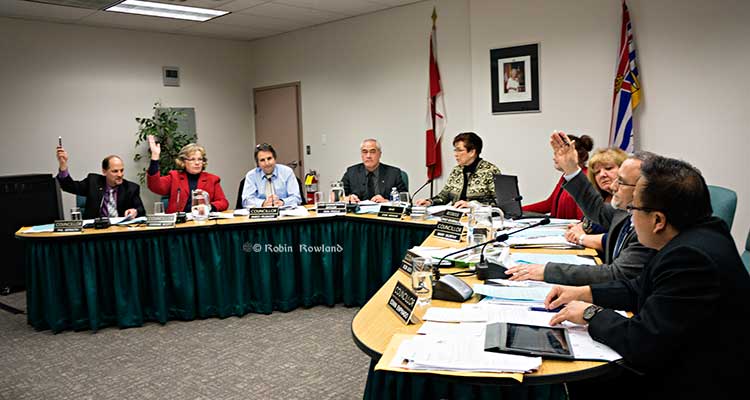
Monday’s District of Kitimat Council meeting was a display of mind-numbing, stubborn political mule-headedness.

After a couple of hours of procedural wrangling, confusion over motions and often just plain dumb discussion, four of the seven members of District Council ignored the recommendations from District staff and suggestions from public delegations, and with their majority decided to stick with the confusing, convoluted Enbridge Northern Gateway Plebiscite question for the vote on April 12.

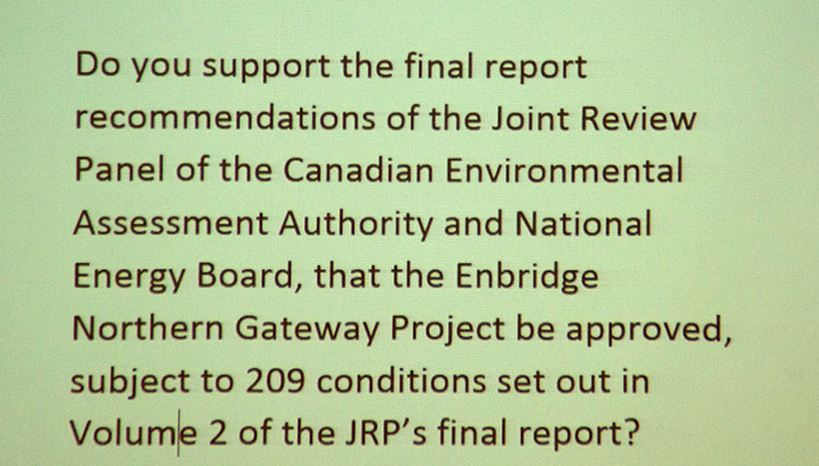
The question (corrected slightly from the previous week’s version) reads:

Do you support the final report recommendations of the Joint Review Panel (JRP) of the Canadian Environmental Assessment Agency and National Energy Board, that the Enbridge Northern Gateway project be approved, subject to 209 conditions set out in Volume 2 of the JRP’s final report?

In May 2012, at the time of the first omnibus bill, Northwest Coast Energy News compared Kitimat Council to a Junior B team up against the NHL All Stars. We hereby apologize to every Junior B player, coach, trainer and referee across this country for comparing them to Kitimat Council. For a community that is in the “bush” one hesitates to use the pejorative term bush league. But in this case the term is correct. District of Kitimat Council is like a bush league beer team playing against the NHL All Stars.

Kitimat has to deal with the major leagues– that is the world’s biggest corporations, Shell, Chevron, Apache, Mitsubishi, PetroChina, Korea Gas, not to mention Rio Tinto. And then there’s Enbridge. Kitimat has to deal with a federal government that sees Kitimat as nothing more than an expendable pawn in Conservative economic and reelection strategies and the province of BC, which under Premier Christy Clark, sees Kitimat as a goose laying golden eggs – as long as most of those eggs go south to the Lower Mainland.

So far in dealing with those companies and higher levels of government, Kitimat Council has acted like Oliver Twist, “Please, sir, can I have some more?”

The Haisla Nation, now under the leadership of Chief Counsellor Ellis Ross, on the other hand, has acted like a top level team (whether NBA or NHL) in dealing with the world’s biggest companies and acted on behalf of the Haisla’s best interests. Ross has not been afraid to admit, on the record, with main stream media interviews, that sometimes he and the Haisla Nation Council have made mistakes in dealing with transnational corporations. But Ross has said he and the HNC learn from those mistakes and do better next time. There appears to be a good working relationship with the Haisla and the companies working to develop Kitimat. Neither side gets everything but the relationship is there.

Now the Haisla have gone to the Federal Court of Appeal and filed an extensive challenge to the Joint Review Panel report, outlining what the Haisla believe are serious flaws in the Joint Review Panel, including asking the court to find that the JRP did not follow requirements of the Canadian Environmental Assessment Agency, while the Kitimat plebiscite presumes the JRP did follow CEAA rules.

Kitimat Council has yet to learn anything from its on going sorry record of making mistake after mistake.

If those council members who voted for the confusing ballot thought that their actions would do anything to unite this community, they were wrong. They’ve already alienated everyone on both sides of the issue who wanted a simple Do you support the Northern Gateway project yes or no question?

Kitimat plebiscite question
The Kitimat Northern Gateway plebiscite question as projected at the Council Chambers Jan 13, 2014. (Northwest Coast Energy News)

Just what does the question mean? Are you in favour of the Joint Review Panel? Or you in favour of Enbridge Northern Gateway? Both? Neither? What if you support Enbridge Northern Gateway but believe the JRP has no credibility? (There are people in Kitimat who are quietly saying that—they support Northern Gateway but have no trust in the JRP or the federal government to enforce the conditions. There are others who say the JRP did a good job and still oppose Northern Gateway). What if you are in favour of 50 or 150 of the JRP recommendations but oppose others—like the use of temporary foreign workers? Rather than two sides with an uncertain middle, there are now multiple sides, with an even more uncertain muddled middle.

When asked Monday night what Council would do with the question, the response was incoherent. It could depend on voter turn out. What happens if the turn out is low because the public doesn’t understand the question? What if the turn out is less than the last municipal election? More? What if the turnout is 90 per cent but a majority vote undecided? Could construction workers who may be eligible to vote because they’ve been here for six months but have no stake in the community overwhelm the votes of long time residents?

Council refused to say whether a simple majority of 50 per cent plus one yes or no (not counting undecideds) is sufficient to decide the issue or whether some super majority, 60 per cent 66 per cent or 75 per cent will mean something? How are Council going to decide? Are they going to decide now or after the vote? Once Council has the vote in hand, what do they do with that vote? Oppose Enbridge if the vote is a majority no? Welcome Enbridge if the vote is yes? Or just keep on doing nothing? (which is not being neutral).

Ask any business analyst and the one thing they will tell you is that business hates uncertainty, uncertainty means hesitation to invest, hesitation to commit. Kitimat Council has just made everything more uncertain than ever. Business will take note.

Big league games mean big league coverage. I know from colleagues that not only the national media, but major international media are considering coming to Kitimat for the April 12 plebiscite. The vote is a “news peg” that lets media that haven’t been covering Kitimat on a regular basis bring their readers and viewers up to date on an important story.

If Kitimat Council is incapable of explaining the plebiscite question to the people who actually live here, how can Kitimat’s politicians explain the question to a fly-in reporter who has never been to British Columbia and who, at this moment, probably thinks JRP is an energy drink? How does a viewer or reader in New York, London, Sydney or Tokyo understand what people here are voting for or against, if the people here don’t understand it?

A possible plebiscite debacle seen on 24 hour satellite channels and read on millions of tablets and phones (as well as surviving newspapers) around the world won’t do much for Kitimat’s reputation for political competence and ability to play well with others. The world’s business community will take note of that.

The word bush league comes to mind.


An intelligent suggestion

Patricia Lange at Kitimat Council
Patricia Lange asks Council to have both sides of the Northern Gateway issue get together to come up with an acceptable plebiscite question. (Robin Rowland/Northwest Coast Energy News)

There was one intelligent, last minute suggestion about the Enbridge Northern Gateway plebiscite question at Monday’s council meeting, a solution to the conundrum of a proper question, but one that the stubborn council is unlikely to adopt.

Patricia Lange was not a scheduled delegate. She came forward after Mayor Joanne Monaghan asked it there was anyone else with a comment.

“I just want to say that the Plebiscite Question is convoluted and it appears biased to me,” she told Council. “Although I am not a member of an environmental group, I would suggest that the wording of the question be put together by somebody from the Douglas Channel Watch and somebody that’s a proponent of this project so the community can see the question is not biased.”

In our view, Lange has hit on the ideal solution. While the proponent, the Enbridge Northern Gateway company should not be included in deciding the wording of the plebiscite question, the Kitimat Economic Development Association, which generally favours the project, should be.

District Council wasn’t involved the Joint Review Process. They should have been but they weren’t. Right now most on Council are handling the JRP like a student who skipped every class for two years and is now desperately cramming for a final exam. Both Douglas Channel Watch and the Kitimat Economic Development Association, on the other hand, have been deeply involved in the Northern Gateway issue since the beginning and either participated in or closely followed the JRP.

Over the past couple of years, Northwest Coast Energy News has spoken both on the record and on background to members of DCW and KEDA.

Both groups are not that far apart. Both members of DCW and KEDA have told me, independently and without knowledge of their opposite numbers are saying the same thing, that they want an economically prosperous, healthy and environmentally viable future for their grandchildren in Kitimat. They just disagree on how to get there.

KEDA members have said they want proper, enforceable but economically viable environmental restrictions on any industrial development in this region. DCW members have repeatedly said they do not oppose industrial development as long as it respects the environment.

In an ideal world, the District would follow Lange’s suggestion and appoint three members of DCW and three members of KEDA to come up with a proper question or questions. District Deputy CAO, Warren Waycheshen, who is an excellent facilitator, could be the chair of the committee and keep things moving. That committee could probably come up with questions acceptable to the entire community on a retreat lasting just an afternoon.

It’s not an ideal world. The District of Kitimat has a highly competent staff who prepared reports to council on the plebiscite, reports that were ignored and rejected. Delegations, most admittedly from the environmental side, appeared before council to argue for a simple question and presented persuasive and eloquent arguments that were brushed off.

Council spent some time Monday night trying to define the term “leadership.” In the end they decided that leadership was staying in their silos and refusing to deal with big league questions. Council is bush league, that is why they won’t take the risk of adopting Lange’s suggestion for the advocates of both sides to meet, do their civic duty and draw up unbiased questions.

After Monday’s debacle, there is already a lot of talk on social media about “throwing the bums out.” It’s a little early for that. District of Kitimat Council has a few months for members to prove that they are worthy of being called up to the majors, to become (to borrow Christy Clark’s phrase) a “world class” council. If councillors show over the coming months that they are not up to the job, the time will come in the November elections to vote for competent candidates for council who are ready to play in the big leagues (if there are actually candidates who have major league potential willing to run).

How Gateway’s plans to dredge Douglas Channel show the limitations of the JRP mandate and ruling

(First in series of reports on how the Joint Review Panel report will affect the Kitimat region)

JRP map of blasting on Douglas Channel
Joint Review map of Northern Gateway plans for dredging and blasting on Douglas Channel (JRP)


If there is a significant flaw in the Joint Review Panel report on Northern Gateway, it can be found in the panel’s analysis of Enbridge Northern Gateway’s plans to blast and dredge at the proposed Kitimat terminal site.

While the Joint Review Panel does consider what it calls “cumulative effects,” the panel plays down those effects and offers no specifics about interaction between the Northern Gateway project and the two liquified natural gas projects, the KM LNG project at Bish Cove and the BC LNG floating terminal at the old log dump.

It appears the JRP considered the legacy effects of the Rio Tinto Alcan smelter and other Kitimat industries while not taking into consideration future development.

The dredging and blasting planned by Northern Gateway, as Enbridge said in its evidence,  appears to have only a minimal effect on Douglas Channel.

A glance at the map in the Joint Review ruling shows that that the dredging and blasting site is directly opposite Clio Bay, where Chevron, in partnership with the Haisla Nation, plan a remediation project using marine clay from the Bish Cove construction site to cap decades of sunken and rotting logs.

The Clio Bay project was not part of the evidence before the Joint Review Panel, the plans for the project were not formulated until well after the time for evidence before the JRP closed. But those deadlines show one area where the rules of evidence and procedure fail the people of northwestern BC.

The JRP is a snapshot in time and changes in the dynamics of the industrial development in the Kitimat Arm are not really considered beyond the terms of reference for the JRP.

It appears from the report that Enbridge plans to simply allow sediment from the blasting and dredging to float down Douglas Channel, dispersed by the currents and the outflow from the Kitimat River.

Northern Gateway said that dredging and blasting for marine terminal construction would result in a sediment plume that would extend over an area of 70,000 square metres for the duration of blasting activities.

Approximately 400 square metres of the assessed area of the marine terminal is expected to receive more than 1 centimetre of sediment deposition due to dredging. Outside of this area, typical sediment deposition levels alongshore where sediment is widely dispersed (a band approximately 4 kilometres long and 400 metres wide) are very low; in the range of 0.001 to 0.1 centimetres. Dredging and blasting activities are expected to occur over a period of approximately 18 weeks.

Northern Gateway expected most of the sediment plume created by construction activities to be minor in relation to natural background levels.

Northern Gateway would use bubble curtains to reduce pressure and acoustic effects of blasting, and silt curtains to reduce the effect of sedimentation from dredging. It said that bubble curtains are used extensively for other activities, such as pile driving, to reduce the effect of high pressure pulses that can cause injury to fish.

It added that bubble curtains have been tested extensively with blasts, and literature shows they are effective.

Northern Gateway said that physical effects from suspended sediment on marine fish and invertebrates could include abrasion and clogging of filtration mechanisms, which can interfere with ingestion and respiration. In extreme cases, effects could include smothering, burial, and mortality to fish and invertebrates. Direct chemical-related effects of suspended sediment on organisms, including reduced growth and survival, can also occur as a result of the uptake of contaminants
re-suspended by project construction activities, such as dredging and blasting, and as a result ofstorm events, tides, and currents.

The Haisla Nation and Raincoast Conservation objected to Northern Gateway’s figures, noting

Northern Gateway’s sediment and circulation model and its evidence related to contaminated sediment re-suspension at the terminal site. Both parties said that the sediment model was applied for the spring, when the increase in total suspended solids would be negligible compared to background values. In the event of delays, blasting and dredging would likely occur at other times of the year when effects would likely be higher, and these scenarios were not modelled.

The panel’s assessment of the area to be blasted found few species:

Species diversity within Kitimat Arm’s rocky intertidal community is generally low. Barnacles, mussels, periwinkles, and limpets can be found on rocky substrate. Sea urchins, moon snails, sea anemones, sea stars, and sea cucumbers are in shallow subtidal areas. Sandy areas are inhabited by commercially-harvested bivalves such as butter clams and cockles.

Northern Gateway told the JRP that it would “offset” any damage to Douglas Channel caused by the blasting and dredging

Northern Gateway said that construction, operations, and decommissioning of the marine terminal would result in both permanent and temporary alteration of marine fish habitat. Dredging and blasting, and installing physical structures in the water column for the marine terminal would permanently alter marine fish habitat. Based on the current terminal design, in-water site preparation would result in the physical alteration of approximately 1.6 hectares of subtidal marine habitat and 0.38 hectares of intertidal marine habitat. Northern Gateway expected approximately 353 square metres of subtidal marine habitat and 29 square metres of intertidal habitat to be permanently lost.This habitat would be compensated for by marine habitat offsets.

The project’s in-water vertical structures that would support the mooring and berthing structures could create new habitat, offsetting potential adverse effects. The structures may act as artificial reefs, providing marine fish habitat, food, and protection from predation. Although organisms currently inhabiting the work area would be killed, the exposed bedrock would be available for colonization as soon as the physical works are completed.

In its finding on marine sediment, the panel, as it does throughout the ruling, believes that the disruption to the environment caused by previous and ongoing human activity, means that the Northern Gateway Kitimat terminal won’t make that much difference.

Sediment quality in the marine environment is important because sediment provides habitat for benthic aquatic organisms. Northern Gateway’s baseline data for the area immediately surrounding the marine terminal indicated some contamination of water, sediments, and benthic organisms from previous industrial activity. Industrial activities in the Kitimat area have released contaminants through air emissions and effluent discharges since the 1960s. Sources of contaminants to Kitimat Arm
include effluent from a municipal wastewater treatment plant, the Alcan smelter, Methanex Corporation’s methanol plant, and the Eurocan pulpmill, as well as storm water runoff from these operations and the municipality.

Area is largely controlled by natural outflow from the Kitimat River with suspended sediment levels being highest during peak river runoff (May to July, and October) and lowest during winter. Storm events, tides, and currents can also suspend sediments. Levels of total suspended solids fluctuate seasonally and in response to climatic variations, but are generally highest during the summer.

Commercial and recreational vessels currently operating in the area may increase suspended solids by creating water turbulence that disturbs sediments. Given the current sediment contamination levels and the limited area over which sedimentation from construction activities would be expected to disperse, the Panel finds that the risk posed by disturbed contaminated sediment is low. Northern Gateway has committed to monitoring during construction to verify the predicted effects on sediment and water quality for both contaminants and total suspended solids..

The dredging and blasting section of the Joint Review Report is small when compared to the much more extensive sections on pipeline construction and tanker traffic, and the possible effects of a catastrophic oil spill.

Although minor, the marine sediment section exposes the question that was never asked, given the disruptions from years of log dumping at Clio Bay and Minette Bay and the decades of  developments at the mouth of the Kitimat River, and future development from LNG, when do cumulative effects begin to overwhelm? How much is enough? How much is too much? If every project continues to be viewed in isolation, what will be left when every project is up and running?


Joint Review Panel tells northwestern BC to bear the “burdens” of Northern Gateway for the good of Canada


Joint Review Panel cover
Cover of Volume 1 of the Joint Review Panel ruling on Northern Gateway


If you read both the 76 pages of Volume One of the Northern Gateway Joint Review decision and the 417 pages of Volume 2, a total of 493 pages, one word keeps reappearing. That word is “burden.”

The JRP panel asks “How did we weigh the balance of burdens, benefits, and risks?”

And it says:

Many people and parties commented on the economic benefits and burdens that could be brought about by the Enbridge Northern Gateway Project. In our view, opening Pacific Basin markets wouldbe important to the Canadian economy and society. Though difficult to measure, we found that the economic benefits of the project would likely outweigh any economic burdens.

The JRP notes:

The Province of British Columbia and many hearing participants argued that most of the project’s economic benefits would flow to Alberta, the rest of Canada, and foreign shareholders in oil and pipeline companies. They said British Columbia would bear too many of the environmental and economic burdens and risks compared to the benefits.

But, as the panel does throughout the ruling, it accepts, with little, if any, skepticism, Northern Gateway’s evidence and assertion:

Northern Gateway said about three-quarters of construction employment would occur in British Columbia, and the province would get the largest share of direct benefits from continuing operations.

It does touch on the “burdens” faced by the Aboriginal people of northern BC and others in the event of a catastrophic spill.

In the unlikely event of a large oil spill, we found that there would be significant adverse effects on lands, waters, or resources used by Aboriginal groups. We found that these adverse effects would not be permanent and widespread. We recognize that reduced or interrupted access to lands, waters, or resources used by Aboriginal groups, including for country foods, may result in disruptions in the ability of Aboriginal groups to practice their traditional activities. We recognize that such an event would place burdens and challenges on affected Aboriginal groups. We find that such interruptions would be temporary. We also recognize that, during recovery from a spill, users of lands, waters, or resources may experience disruptions and possible changes in access or use.

And the JRP goes on to say:

We recommend approval of the Enbridge Northern Gateway Project, subject to the 209 conditions set out in Volume 2 of our report. We have concluded that the project would be in the public interest. We find that the project’s potential benefits for Canada and Canadians outweigh the potential burdens and risks….

We are of the view that opening Pacific Basin markets is important to the Canadian economy and society. Societal and economic benefits can be expected from the project. We find that the environmental burdens associated with project construction and routine operation can generally be effectively mitigated. Some environmental burdens may not be fully mitigated in spite of reasonable best efforts and techniques…. We acknowledge that this project may require some people and local communities to adapt to temporary disruptions during construction.

As for the chance of a major oil spill, again the JRP talks about burdens:

The environmental, societal, and economic burdens of a large oil spill, while unlikely and not permanent, would be significant. Through our conditions we require Northern Gateway to implement appropriate and effective spill prevention measures and spill response capabilities, so that the likelihood and consequences of a large spill would be minimized.

It is our view that, after mitigation, the likelihood of significant adverse environmental effects resulting from project malfunctions or accidents is very low.

And concludes:

We find that Canadians will be better off with this project than without it.

In the Joint Review ruling is one fact. Northern British Columbia must bear the “burden” of the Northern Gateway project for the good of Alberta and the rest of Canada. The JRP accepts, without much questioning, Northern Gateway’s assurances that environmental disruptions during construction will be minimal and that the chances of a major spill from either a pipeline or a tanker are minimal.

Canadians as a whole may be better off with the Northern Gateway. Whether the people who live along the pipeline and tanker route will be better off is another question, one which the Joint Review Panel dismisses with casual disdain.

Cover of JRP ruling
Cover of Volume 2 of the Joint Review rulng on Northern Gateway

The politics of the Joint Review Panel

There are actually two Joint Review Panel reports.

One is political, one is regulatory. The political decision by the three member panel, two from Alberta and one from Ontario, is that the concerns of northwestern British Columbia are fully met by Enbridge Northern Gateway’s assurances. There is a second political decision, found throughout both volumes of the report, and the reader sees the Joint Review Panel has the notion that many parts of the environment have already been degraded by previous human activity, and that means the construction and operation of the Northern Gateway will have little consequence.

Here is where the Joint Review Panel is blind to its own bias. With its mandate to rule on the Canadian “public interest,” the panel makes the political determination that, in the Canadian public interest, northwestern BC must bear the “burden” of the project, while other political issues were not considered because, apparently those issues were outside the JRP’s mandate.

…some people asked us to consider the “downstream” emissions that could arise from upgrading, refining, and diluted bitumen use in China and elsewhere. These effects were outside our jurisdiction, and we did not consider them. We did consider emissions arising from construction activities, pipeline operations, and the engines of tankers in Canadian territorial waters.

During our hearings and in written submissions, many people urged us to include assessment of matters that were beyond the scope of the project and outside our mandate set out in the Joint Review Panel Agreement. These issues included both “upstream” oil development effects and “downstream” refining and use of the products shipped on the pipelines and tankers…Many people said the project would lead to increased greenhouse gas emissions and other environmental and social effects from oil sands development. We did not consider that there was a sufficiently direct connection between the project and any particular existing or proposed oil sands development or other oil production activities

If someone in Northwestern British Columbia favours the Northern Gateway project, if they believe (and many people do) what Enbridge Northern Gateway says about the economic benefits, then it is likely they will accept the burden and the further environmental degradation imposed by the Joint Review Panel on this region of British Columbia.

If, on other hand, for those who are opposed to the project, then the decision to impose the burden on this region is both unreasonable and undemocratic (since no one in northern BC, in the energy friendly east or the environmental west has been formally asked to accept or reject the project). For those opposed to the project, the idea that since the environment has already been disrupted by earlier industrial development, that Canadians can continue to degrade the environment with no consequence will only fuel opposition to the project.

As for the assertion that green house gas emissions were not part of the Joint Review Panel’s mandate, that is mendacious. The panel made a political decision on the role of the people of northwestern BC and the state of northwestern BC’s environment. The panel made a political decision to avoid ruling on the role of Northern Gateway in contributing to climate change or the larger world wide economic impact of pipelines and the bitumen sands.

Regulations

The Joint Review Panel is supposed to be a regulatory body and should be pipeline, terminal and tanker project go ahead after the expected court challenges from First Nations on rights, title and consultation and from the environmental groups, then those 209 conditions kick in.

While the Joint Review Panel largely accepts Enbridge Northern Gateway’s evidence with little questions, in some areas the panel does find flaws in what Northern Gateway planned. In a few instances, it actually accepts the recommendations from intervenors (many from First Nations, who while opposed to the project, successfully demanded route changes to through environmentally sensitive or culturally significant territory.)

When it comes to regulations, as opposed to politics, the Joint Review Panel has done its job and done it well. If all 209 conditions and the other suggestions found in the extensive second volume of the ruling are actually enforced then it is likely that the Northern Gateway will be the safe project that Enbridge says it will be and actually might meet BC Premier Christy Clark’s five conditions for heavy oil pipelines across BC and tankers off the BC coast.

But and there is a big but.

The question is, however, who is going to enforce the 209 conditions? In recent conversations on various social media, people who were quiet during the JRP hearings, have now come out in favour of the pipeline project. Read those comments and you will find that the vast majority of project supporters want those conditions strictly enforced. Long before the JRP findings and before Premier Christy Clark issued her five conditions, supporters of the Northern Gateway, speaking privately, often had their own list of a dozen or two dozen conditions for their support of the project.

The people of northwestern BC had already witnessed cuts to Fisheries and Oceans, Environment Canada and the Canadian Coast Guard in his region even before Stephen Harper got his majority government in May 2011.

Since the majority government Harper has cut millions of dollars from the budgets for environmental studies, monitoring and enforcement. The Joint Review Panel began its work under the stringent rules of the former Fisheries Act and the Navigable Waters Act, both of which were gutted in the Harper government’s omnibus bills. Government scientists have been muzzled and, if allowed to speak, can only speak through departmental spin doctors. The Joint Review Panel requires Enbridge Northern Gateway to file hundreds of reports on the progress of surveying, environmental studies, safety studies, construction plans and activities and project operations. What is going to happen to those reports? Will they be acted on, or just filed in a filing cabinet, perhaps posted on an obscure and hard to find location on the NEB website and then forgotten?

Will the National Energy Board have the staff and the expertise to enforce the 209 conditions? Will there be any staff left at Environment Canada, Transport Canada, Fisheries and Oceans and the Canadian Coast Guard where the conditions demand active participation by government agencies, or ongoing consultation between federal agencies and Northern Gateway? Will there actual be monitoring, participation and consultation between the project and the civil service, or will those activities amount to nothing more than meetings every six months or so, when reports are exchanged and then forgotten? Although Stephen Harper and his government say the Northern Gateway is a priority for the government, the bigger priority is a balanced budget and it is likely there will be more cuts in the coming federal budget, not enhancements to environmental protection for northwestern BC.

The opponents of the project might reluctantly agree to the 209 conditions if Harper government forces the project to go ahead. It will be up to the supporters to decide whether or not they will continue their support of Northern Gateway if the 209 conditions are nothing more than a few pages of Adobe PDF and nothing more.


Bitumen excluded from data for federal tanker study, documents reveal

Tanker risk map
Transport Canada tanker report map shows current risk for spills in BC (Transport Canada)


Genivar report
Cover of Genivar tanker report (Transport Canada)


The possible effects of a bitumen spill on Pacific waters were not considered in the oil response preparedness report released last week by the Harper government, the background data study reveals.

The consulting firm that did the study for Transport Canada, Genivar Inc, had no reliable data on the effect of a bitumen tanker disaster—because, so far, there has been no major ocean disaster involving diluted bitumen.

Instead, Genivar, based its findings on potential hazards and response on existing data on crude oil spills.

The Genivar study, however, does warn, that if the Enbridge Northern Gateway project does go ahead,  the spill risk from diluted bitumen carrying tankers in Douglas Channel and along the north Pacific coast will jump from “low” or “medium” to “very high.” If the twinning of the Kinder Morgan pipeline goes ahead, then the risk in Vancouver also jumps to “very high.”

The question of how bitumen might behave in the cold and choppy waters of the North Pacific was hotly debated during the Northern Gateway Joint Review hearings earlier this year. Enbridge Northern Gateway based its position on laboratory studies, studies that were challenged by environmental and First Nations intervenors, pointing both to the unknowns of the ocean environment and the continuing problems Enbridge has in cleaning up the spill in the Kalamazoo River in Michigan.

Genivar tried to base its report to Transport Canada on existing data on oil spills and related hazards. What it found instead is that that there are often gaping holes in the reporting and monitoring of oil spills world wide, especially small and medium sized spills.

Lack of data also meant that Genivar had little to go on when it calculated the effect on an oil spill on key areas of interest to northwest British Columbia, the recreational fishery and tourism.
Genivar, however, did uncover disturbing data about the long term effects of oil spills, studies that show even minute amounts of remaining oil can still disrupt the marine environment 40 years after an event.

The Genivar report, Risk Assessment for Marine Spills in Canadian Waters Phase 1: Oil Spills South of 60th Parallel, was completed in November, then passed on to the “expert panel” that released their own report: A Review of Canada’s Ship-source Oil Spill Preparedness and Response Regime — Setting the Course for the Future. That second report was based not only on the data provided by Genivar but on the expertise of three panel members, their visits to some locations and input from government, industry, First Nations and municipalities.

Transport Minister Lisa Raitt and Natural Resources Minister Joe Oliver unveiled the second report at a glitzy media event  in Vancouver on Tuesday, December 10. At that time the expert panel report was released to the media along with an abstract of the data.

The actual data report was not posted; it had to be requested through the Transport Canada website, which is how Northwest Coast Energy News obtained the background study.

High risk for Kitimat

Transport Canada tanker report
Expert panel tanker risk assessment report cover (Transport Canada)

The expert panel found “a very high risk” of oil spills in two areas of the Pacific Coast, in the north around the ports of Kitimat and Prince Rupert and in the heavy ocean traffic area of southern British Columbia, especially Port Metro Vancouver and into Washington State.

The expert panel made 45 recommendations that covered a wide range of issues including eliminating the present $161-million liability limit for each spill and replacing it with unlimited liability for polluters, annual spill training involving the Canadian Coast Guard, Environment Canada, provincial and local authorities and the private sector, increased and improved annual spill training exercises, basing risk assessment on local geography and conditions and faster emergency responses to spills.

The expert panel calls for greatly increased research on the ocean environment at a time that Harper government has been gutting environmental research across Canada, while spinning that its policies are “science based.”

The science and technology around both the movement of oil and spill response has advanced significantly over the past several decades. We feel that while some aspects of the Regime have kept pace with these developments, in some areas, Canada has fallen behind world-leading countries like Norway and France. This can be attributed to a general lack of investment in research and development as well as the lack of coordination between industry and government over research priorities.

The Government of Canada should work closely with industry to establish a national research and development program for oil spill preparedness and response. The program should be co-funded by industry and the Government, and the research priorities should be set through a collaborative process that involves academia, where possible. Like the Regime itself, we view this program as a partnership between industry and government.

We envision that this program would also seek to leverage the work being done internationally on oil spill preparedness and response. The program should seek to establish partnerships with other world-leading countries in order to stay current on international advances and new technologies.

The expert panel, however, does not say how the federal government is expected to pay for meeting BC Premier Christy Clark’s condition for a “world class” spill prevention and response system at a time that Finance Minister Jim Flaherty is determined to balance the budget and the Harper government is continuing to cut back government services.

Bitumen excluded

On bitumen, the Genivar data study says:

Modified bitumen products represent the majority of the “crude carried as cargo” in
Pacific sub-sector 5. They are not modelled as a separate category in this spill behaviour analysis but are represented as “persistent crude”.

Changes in spill behaviour depend to some extent on the environmental conditions at the time of the spill, as described in greater detail below. However, over the range of wind and sea conditions typically experienced in the Canadian marine environment, changes in oil properties are not overly sensitive to variations in climatic values, so a single set of wind and sea conditions will be used in the analysis.

The idea that “changes in oil properties” not being sensitive to variations in climate was also frequently challenged before the Joint Review Panel.

On the increase in traffic volume if the Northern Gateway project goes ahead, the Genivar report says.

Enbridge Inc. has proposed to construct a marine terminal at Kitimat, B.C. and a dual pipeline from the terminal to oil sands production in northern Alberta. The terminal would handle up to 193,000 barrels/day of imported diluents (i.e., low-gravity condensate) that would be piped to Alberta and used to dilute bitumen to enhance its flow properties. The diluted bitumen would then be piped to Kitimat at rates up to 525,000 barrels/day that would be shipped by tanker to export to markets in Asia and California.

At full capacity, the import of diluent and export of diluted bitumen would total up to 35 Mt/year. This amount is comparable to the currently-shipped volume in the Pacific sector related to volumes being exported from Vancouver and related to volumes being exported from the Alaskan to Washington State trade.

It goes on to say that the current tanker traffic on the north Pacific coast “has negligible risk in the near shore and intermediate zones, but significant potential spill frequency in the deep-sea zone related to the Alaskan trade.” Similarly, according to Genivar the environmental risk in the region “currently ranges from ‘medium’ to “very low” from near shore to deep-sea zones, respectively…. mainly driven by a combination of physical and biological features.”

The increase in traffic from Northern Gateway would likely increase the environmental risks. The the near shore risk from would jump from “very low” to “very high.” For the largest spill category, deep-sea risk would likely increase from “low” to “medium.”

No data on recreational or traditional First Nations fishery

To study the effect on an oil spill on the fishery, Genivar used data from the Department of Fisheries and Oceans as the provinces to gauge “the port value of commercial fishing and the value of the fish, shellfish and aquaculture” in each zone it studied and then compared it to the the national averages for commercial fishery. Those figures included any commercial fishery by First Nations.

But Genivar noted, there is no reliable data on either the recreational fishery or the First Nations traditional, food, social and ceremonial fishery, saying:

It is important to highlight that this indicator does not consider recreational or traditional fishing. The importance of this industry is notable and an oil spill could damage the recreational fishing stock as well. However, the absence of comparable data and the fact that this study is restricted to federal and international data, and some provincial data from Quebec and Ontario for commercial fisheries, limits the ability to include recreational fishing… Nevertheless, as an absolute index, it will provide an overall vulnerability in the event of an oil spill.

The ongoing impact of cutbacks at Fisheries and Oceans has had a continuing impact on the northwest, especially in the controversial halibut recreational fishery, where DFO has admitted that it is basically guessing the size of each year’s recreational halibut catch.

Tourism

Genivar also notes that lack of reliable data on the effect on a oil spill on tourism. The consultants go so far as to say one of the indicators they will use to measure the effect of any oil spill on tourism would come from “data extracted from the 2011 National Household Survey at the census division level and the accommodation and food services data will be used.”

The “National Household Survey” is also known as the long form census and it is the National Household Survey that the Harper government made voluntary rather mandatory, decreasing the reliability of the data. Global News recently analyzed those who had contributed to the survey and found that it poor people, the very rich and people in low population areas were least likely to fill out the voluntary census—which means the data for northwest BC is likely highly unreliable from the 2011 survey even though “The census divisions in coastal regions will be selected for each of the sub-sectors. This method will express the economic vulnerability of each sub-sector to a potential collapse in tourism following a spill.”

Despite the importance of cruise ship traffic on the west coast, Genivar notes, “In Canada, data for passenger vessels were unavailable.”

It also notes that “this study does not specifically take into account national parks and other landmarks, since their influence on tourism is indirectly included in the tourism employment
intensity index” so that Genivar could create what it calls the Human-Use Resource Index (HRI), even though that index appears to be based on incomplete data.

Commentary: In the tanker study, the District of Kitimat was missing in action

kitimatlogoThe list of participants in the oil spill preparedness and response study released last week by the federal government shows two glaring no shows, the District of Kitimat and Rio Tinto Alcan.
The Haisla Nation and the Gitga’at Nation did provide written submissions to the panel.

The expert panel was set up by the federal government to review “oil handling facilities and ship-source oil spill preparedness and response.” The expert panel was to review the “structure, functionality and the overall efficiency and effectiveness of the system, as well as analyzing the requirements for hazardous and noxious substances, including liquefied natural gas.”

Transport Canada tanker report
Expert panel tanker risk assessment report cover (Transport Canada)

As well as commissioning the Genivar report on the state of oil spill preparedness and consequences, the panel interviewed stakeholders and visited a few key locations, including Port Metro Vancouver.

The panel also invited any interested groups to submit documents or their own views to be taken into consideration.

Among the stakeholders interviewed by the panel were companies and organizations very familiar to Kitimat; Chevron and Shell, main partners in two of the LNG projects; Enbridge, which has proposed the Northern Gateway Pipeline and Kinder Morgan which has proposed expanding the dilbit pipeline on the Lower Mainland. Other stakeholders included Coastal First Nations, the Prince Rupert Port Authority, SMIT Marine and the Vancouver Port Authority.

As well as the Haisla and the Gitga’at, five west coast municipalities submitted their own reports to the tanker panel, both the city and districts of North Vancouver, the city of Richmond, the District of Ucluelet and the District of West Vancouver. San Juan County in Washington State also made a submission to the panel. So did the Prince Rupert and Vancouver Port authorities.

Chevron, Enbridge, Imperial Oil, Kinder Morgan, Pacific Northwest LNG, Seaspan Marine, and the Union of BC Municipalities, among others also submitted their views to the panel.

So why didn’t the District of Kitimat participate? When it came to the Enbridge Northern Gateway Joint Review, the mayor and council always maintained their neutrality motion meant that the District would not be an active participant. That was always a short sighted viewpoint. The District should have participated actively in the JRP in such a way as to protect the region’s interests where necessary while remaining neutral. If the District of Kitimat sat out the tanker panel because of the Northern Gateway neutrality policy, that was no excuse, because the expert panel’s mandate specifically included LNG.

Tanker traffic is a potential threat to the San Juan Islands (the Gulf Islands on the American side of the border). It is astounding that San Juan County would think that the Canadian tanker panel was important enough to make a submission and the District of Kitimat did not.

RTA logoWhat about Rio Tinto Alcan? Kitimat has been a private port for 60 years, run first by Alcan and then by Rio Tinto Alcan. Why wasn’t RTA asked to participate as a stakeholder? Why didn’t RTA make a submission? Those who are pushing the Northern Gateway terminal always like to say that tankers have been calling at Kitimat for those 60 years. That is true. Of course, none of those tankers have been the Very Large Crude Carriers proposed by Northern Gateway. However, those 60 years means that RTA has the expertise on the Port of Kitimat and Douglas Channel. RTA probably has important data that could have helped both the expert panel and Genivar (which pointed out the paucity of data on small and medium sized tankers). In not participating in the tanker panel submissions and possibly not providing valuable data on Douglas Channel, RTA neglected its social responsibility both to the community of Kitimat and the rest of the province of British Columbia.

Tanker study shows huge gaps in shipping and hazard data, documents show

The study of tanker shipping and tanker spills by Genivar for Transport Canada has revealed huge gaps in how the world monitors tanker traffic.

Genivar report
Cover of Genivar tanker report (Transport Canada)

Genivar says

Accident data was acquired from three main sources: the CCG Marine Pollution Incident Reporting System (MPIRS); the Lloyd’s casualty database; and spill incident records maintained by the International Tanker Owners Pollution Federation (ITOPF).

MPIRS lists all marine pollution incidents occurring in Canadian waters (CCG, 2013), with information on the region within Canada in which the incident occurred, type of material spilled, accident cause, and estimated pollution volume with multiple entries for a given incident showing updates of incident status and pollution amounts if applicable. The primary use of MPIRS in this study was for spill incidents in the smaller size categories… for which worldwide data was suspected to be unreliable due to under-reporting. MPIRS appeared to be a comprehensive listing of incidents that occurred in Canadian waters, and a summary of polluting incidents

It goes on to note that some key data has not been updated since the 1990s, largely prior to the introduction of double hulled tankers.

As noted, oil spill accidents were compiled on a worldwide basis.

In order to estimate the frequency for Canada, an exposure variable was required.

A series of studies by the U.S. Minerals Management Service (MMS, now known as
the Bureau of Ocean Energy Management, Regulation and Enforcement) investigated the occurrence rates of tanker accidents against various spill exposure variables and found that the simplest and most reliable indicator was volume of oil transported. Simply put, it was determined that spill rates could be expressed, for a range of spill size categories, as an average number of spills per billion barrels transported.

The MMS studies were updated periodically until the 1990s but have not been revisited since, but they did show a steady decrease in the likelihood of casualties and resulting spill volumes, due to a number of factors including tanker design, increasing governance and overall scrutiny of the marine transportation industry. The phased-in implementation of double-hull tankers may have also had a beneficial effect on spill rates in more recent years, particularly in the category of very large or catastrophic events… In any case, it is important in interpreting accident data to reflect current trends and implemented mitigation measures. The focus was on cargo volumes and accident rates over the past decade.

It goes on to say the volumes of crude carried is also under-reported to Lloyds.

In the case of crude oil and refined products carried as cargo, the exposure variable was simply the volume of each respective category carried on an annual basis for the period of interest. Information from the Lloyds APEX database was used for this purpose; it reports volumes of crude and refined products shipped worldwide, with a breakdown by year, country of origin, and country of destination. Compared with similar data from Canadian sources, the APEX data appeared to significantly under-report the carriage of refined products. As a result, the accident rates estimated and used in this study are likely somewhat conservative, that is, they overstate the likely frequency of refined products carried as cargo. For all calculations involving the potential spillage of refined products as cargo in Canadian waters, and for the apportioning of spill frequency among the various sectors and sub-sectors of Canada, Transport Canada commodity traffic data was used

Again about Lloyds data, until 2010, it was limited in its monitoring of the BC Coast.

In analyzing the Canadian movement data supplied by Lloyds, a major shortcoming was found in the data in that movements recorded prior to 2010 did not include broad classes of vessels such as ferries, passenger vessels, and pilot boats. Given that these vessels comprise a significant proportion of traffic movement in many sectors, only data covering the final two years of the record, 2010 and 2011, were used in the analysis.

The Lloyds data was also limited when it came to oil spills:

One limitation of the MPIRS data was that it did not classify spills as to whether they were from “cargo” as opposed to “fuel”, which would have been helpful in this study as these spill types were analyzed separately. As a result, for spills of refined products, which could have hypothetically been either cargo or fuel, assumptions were made based on the type of vessel involved, the type and severity of the incident, and other notes within MPIRS.

A database was acquired from Lloyds that detailed all marine casualties over the
past ten years regardless of whether the incident involved pollution…
This database was used to provide a breakdown of incidents by cause, and as an
initial listing of those incidents that did result in pollution. The Lloyds data was of
mixed quality when it came to the reporting of polluting incidents, with numerous
records only partially filled out, ambiguities in the reporting of spill volume, and
inconsistencies in the classification of the spilled material. A significant effort was
made to provide consistency and accuracy in the information, including cross-
referencing with other data sources.


So the Genivar report exposes a significant gap in the available data on oil spills.

It is certainly true that the number of major tanker accidents and spills have decreased since the Exxon Valdez disaster, a point frequently made by Enbridge at meetings in northwestern BC.

The expert panel report which said that Canada faces the risk of a major tanker disaster of 10,000 tonnes or more once every 242 years.

The Vancouver Sun quoted Transport Canada spokeswoman Jillian Glover on that risk of a spill on the Pacific Coast as saying. “This value must be understood in relative terms, such that the risk is considered high compared to the rest of the country only…Canada enjoys a very low risk of a major oil spill, evidenced by the lack of Canadian historical spills in the larger categories. Additionally, this risk assessment is before any mitigation measures have been applied, so that is a theoretical number before additional prevention initiatives are taken.”

Note that the government always talks about a “major oil spill,” but it appears from the gaps in the data that predicting the possibility and consequences of a medium sized or smaller oil spill is now not that reliable, even though such a spill could have disastrous effects on a local area. According to a map in both reports, the entire BC coast is at risk for a “low to medium” spill. This echoes the problems with the Enbridge Northern Gateway pipeline, where Enbridge based most of its projections on a “full bore breach” or major pipeline break and did little about a medium sized or smaller leak. Data analysis by Kelly Marsh of Douglas Channel Watch on the possibility of the cumulative effects of a medium sized and possibly undetected pipeline breach could have just as disastrous consequences for the Kitimat valley as a major pipeline break. The same is likely true at sea.

LNG Canada aims to be “first out of the gate” in the rush to develop in Kitimat

LNG Canada meeting
Residents of Kitimat discuss the proposed LNG Canada facility with company officials at the Rod and Gun, Nov. 27, 2013 (Robin Rowland/Northwest Coast Energy News)

LNG Canada says it wants to be “first out of the gate” in the competitive race to send BC’s liquified natural gas to Asian markets.

The company held a well attended open house at the Kitimat Rod and Gun on November 27, with the usual array of posters and experts, to mark the beginning of the environmental assessment process for what is formally called the “LNG Canada Export Terminal Project.:

The LNG Canada Export Project is a partnership of Shell,Canada Energy, Diamond LNG Canada, an (“affiliate” of Mitsubishi), Korea Gas Corporation and Phoenix Energy (an “affiliate” of PetroChina) filed a draft application for an Environmental Assessment Certificate with the BC Environmental Assessment Office and Canadian Environmental Assessment Agency on November 8. The 30-day public comment period on the draft Application Information Requirements started on November 13, 2013 and end on December 13, 2013.

The extensive documentation can be downloaded in PDF format from the BCEAO site. The documents can also be viewed at the Kitimat and Terrace Public Libraries and the LNG Canada office in Kitimat at the old Methanex site.

“What we want to be able to do is actually to provide information in a way that we can provide a lot of conversation with the community, so we can really have a dialogue, to give them a place where they know than go to get answers. We do believe that we can be the best project in British Columbia, the only way we can do that is if we have the support of the community,” LNG Canada’s Susannah Pierce told reporters.

“We would like to be first out of the gate. This is a competitive industry and we’re not just competing in terms of providing Canadian gas to the Asian markets, we’re competing with everyone else for the opportunity to deliver product to market.”

The application says that the all-important Financial Investment Decision will likely be “made mid-decade followed by 4-5 years of construction with commissioning of the first phase to follow.”

The first phase would have a first phase of about 12 million tonnes a year of LNG, with another MTPA (million tonnes per anum) in “one or two subsequent phases.”

Federal, provincial and municipal governments or agencies, First Nations and the general public have the ability to comment on the proposal.

An aerial photo map included in the application shows the footprint of the proposed LNG Canada operation. Although the LNG Canada project is based at the old Methanex plant, the map shows that the LNG plant will take up a much larger area than the original. The old Methanex access road would be widened parallel to the Rio Tinto Alcan smelter and a Cyrogenic Pipeline would cross the Kitimat River estuary to the marine terminal.

LNG Canada footprint map
A map provided by LNG Canada shows the potential footprint of the liquifaction facility and marine terminal next to the Rio Tinto Alcan aluminum smelter. (LNG Canada)

The scope of the project includes one possibly controversial item: “Onsite power generation,” where natural gas would be used to power the cooling equipment to turn the gas into LNG.

The assessment will also look the natural gas receiving and production facility; “a marine terminal able to accomodate two LNG carriers each with capacity up to 265,000 cubic metres (approximately 122,000 DWT) and a materials offloading area; supporting infrastructure and the construction facilities.

The environmental assessment will examine air quality, green house gas management, the acoustic environment (the noise created by the project), soil, vegetation, wildlife, freshwater, esturine fish and habitat, marine resources including fish and fish habitat and marine mammals, water and ground water quality.

The economic and social assessment includes infrastructure, land use, “visual quality,” odour, marine transportation and use, community health and well being, archaeological heritage and human health.

LNG Canada meeting
District of Kitimat Council member Mario Feldhoff discusses the LNG Canada project with a company official at the Open House at the Rod and Gun, Nov. 27, 2013. (Robin Rowland/Northwest Coast Energy News)

The assessment process will also “assess potential cumulative economic, health, social and heritage effects from the Project…interacting cumulatively with similar effects of past, present and future projects activities. The current table of projects to be considered for cumulative effects include the Rio Tinto Alcan Aluminum Smelter and Modernization Project, the Kitimat LNG and Douglas LNG terminals, the possible Enbridge Northern Gateway porject, the new use for the old Methanex and Cenovus operations, the operations at the Sand Hill, the former Moon Bay and current MK Bay Marinas.

Projects further away include LNG and other projects and associated pipelines at Prince Rupert, including expansion of the current ports and the redevelopment of Watson Island. Cruise ship and BC ferry operations will be only considered where they impact the shipping routes. Any forestry operations will also only be considered where they impact the project.

Updated to fix typos, including spelling of Feldhoff

LNG Canada maps air shed study area

Kitimat Airshed Map
Map released by LNG Canada shows the air shed area that the company will study as part of the environmental assessment. (LNG Canada)

Two of the maps filed by the LNG Canada project with provincial and federal environmental assessment agencies look at the air quality problems from the project, including the controversial prospect of cumulative problems from multiple industrial projects in the Kitimat Valley, one of them the RTA Kitimat Modernization Project which will increase sulphur dioxide emissions while decreasing some other emissions.

One map covers what is being called the airshed, in the case of LNG Canada, air quality will be assessed with the LNG facility at its centre. A second map covers the tanker route, and as well as a 40 km square grid around the plant that will also assess Hartley Bay, Kitkatla and Metalkatia which may be impacted by vessel emissions.

As well as scientific data, the assessment will also take into consideration traditional knowledge and traditional use from “aboriginal and other groups.”

The possible cumulative effect on the air quality in the Kitimat valley and surrounding areas has prompted the BC government to commission its own study of the Kitimat airshed.
On Oct 3, the provincial ministries of the environment and gas development announced a $650,000 scientific study “to help inform regulatory and policy development for future industrial activity in the Kitimat area. The goal is to ensure the potential impacts from industrial air emissions are clearly understood prior to new projects being approved and in operation.”
It says

The Kitimat Airshed Impact Assessment Project will look at the cumulative effects of existing and proposed industrial air emissions in the airshed. These include emissions from: an existing aluminium smelter, three proposed LNG terminals, a proposed oil refinery, a crude-oil export facility, and gas-turbine-powered electrical generation facilities. The study will focus on sulphur dioxide and nitrogen dioxide emissions from these facilities.

The study will assess the impact of emissions through a number of scenarios, including their potential effects on water and soil, as well as on vegetation and human health from direct exposure.

BC defines an airshed as

An airshed is generally described as an area where the movement of air (and, therefore, air pollutants) can be hindered by local geographical features such as mountains, and by weather conditions. The most obvious example in British Columbia is a mountain valley. Since air pollution knows no political boundaries, airshed activities may be focused on a single community or on a number of neighbouring communities faced with similar air quality problems and requiring similar action.

The LNG Canada assessment will look at two potential adverse effects, first a change in ambient air quality in the Kitimat airshed or along the marine access route and second any change in acidic deposition pattern in the Kitimat Valley.

The first study will look specifically at estimated levels of “criteria air contaminets” including sulphur dioxide, Nitrogen oxides, carbon monoxide, atmospheric particulate matter and hydrogen sulphide. The particulate matter study will use the international standard of 2.5 micrometres. 

The assessment will also study possible cumulative effects on air quality of multiple projects and those projects over time.

LNG Canada air quality map
LNG Canada map shows the marine and land areas that will be studying for air quality. (LNG Canada)


Commentary: The earthshaking difference between Enbridge and LNG

Joint Review Panel
The Northern Gateway Joint Review panel, Kenneth Bateman, Sheila Leggett and Hans Matthews, listen to final arguments in Terrace, June 17, 2013. (Robin Rowland/Northwest Coast Energy News)

Buried deep in the LNG Canada environmental assessment application, a reader will find a key difference in attitude with at least one of the group of companies planning liquified natural gas development in the northwest and Enbridge Northern Gateway.

It’s an earthshaking difference, since it’s all about earthquakes.

The documents filed by LNG Canada with the BC Environmental Assessment Office and the Canadian Environmental Assessment Agency acknowledge that there is a possibility of an earthquake (a one in 2,475 year event) at the LNG terminal site.

Northwestern British Columbia was shaken by two major earthquakes in the months before the Joint Review Panel concluded its hearings in Terrace. Both were far from Kitimat, but felt across the District. On October 27, 2012, there was a magnitude 7.8 earthquake on the Queen Charlotte Fault off Haida Gwaii. That quake triggered a tsunami warning, although the actual tsunami was generally limited to the coast of Haida Gwaii. Both landline and mobile phone service in Kitimat was briefly disrupted by both the quake and overloads on the system. Kitimat was also shaken by the 7.5 magnitude earthquake centered at Craig, Alaska a few weeks later on January 9, 2013.

With the exception of one vague reference in its final argument documents presented to the Joint Review Panel, Enbridge has stubbornly refused to consider any seismic risk to the region.

That was the company’s policy long before the October. 27, 2012 Haida Gwaii earthquake and was Enbridge policy after October 27, 2012.

In a public meeting in Kitimat on September 20, 2011, more than a year before the Haida Gwaii earthquake, John Carruthers, Northern Gateway president, insisted to skeptical questioners at a community forum at Mount Elizabeth Theatre that there was no earthquake danger to the proposed Northern Gateway pipeline and bitumen terminal in Kitimat.  One of the questioners, Danny Nunes, of Kitimat, asked could the pipes withstand an earthquake? Carruthers repeated that Kitimat was not in an earthquake zone, that the fault was off Haida Gwaii and so would not affect Kitimat.

After the September, 2011 meeting, I asked Carruthers if Enbridge knew about the March 27,1964 “Good Friday” magnitude 9.2 Alaska earthquake that, because of its high magnitude, had caused major shaking in Kitimat. That earthquake destroyed much of Anchorage and triggered tsunamis that caused damage and death across Alaska and in parts of British Columbia, Oregon and California.

Carruthers promised to get back to me and never did.

On June 17, 2013, six months after the Craig, Alaska earthquake, in his opening summation before the Joint Review Panel, Richard Neufeld, lead lawyer for Northern Gateway, stayed on message track, telling the JRP, referring to pipelines: “The route is not seismically unstable. The seismic risk along the pipeline right-of-way is low, with only a few locations of moderate risk encountered, none of which are within the Haisla territory.”

That brought a gasp from spectators in the room, or at least those who had felt the October and January earthquakes.

The following day, June 18, Murray Minchin of Douglas Channel Watch found an anomaly in the Enbridge documentation, arguing in the group’s summation:

“The Proponent’s written final argument gets on shaky ground regarding design and construction of the storage tanks on a ridge beside Douglas Channel in paragraph 249 where they say:

“‘It also involves the safe construction and operation of the Kitimat terminal in Kitimat Arm in an area subject to seismic activity which encompasses both terrestrial and marine components.’

“Now, that’s interesting because isn’t that the first time — the first admission by the Proponent in a little over 10,000 pages of documents that the area they intend to build their project is in a seismically-active area?

“Haven’t they been telling us all along to this point that the only seismic concerns would be from the distant Queen Charlotte fault off of Haida Gwaii?

“Now, this completely contradicts Mr. Neufeld’s statement yesterday where he described the Project area as not “seismically unstable”. So what is it? This is their final argument and they’re contradicting themselves.”

Minchin went on to quote from the Enbridge argument: “’Seismic conditions in the project area have also been addressed.’

“Well, really? Is that a truthful statement, considering Natural Resources Canada has only submitted a preliminary report concerning a 50-kilometre fault line and massive submarine landslides they accidentally discovered last year in Douglas Channel while doing a modern survey of the Channel for navigation hazards.

“How can the Proponent claim to have adequately addressed seismic forces in their design of this Project when they don’t know what those forces are or for what duration they may be subjected to those forces.

“Has there ever been a paleoseismological study in the Project area to establish past earthquake or tsunami history?

“Wouldn’t it be in the best interest of the Proponent, the Panel and Canadians to know the risks before 1.3 billion litres of liquid petroleum products are allowed to be stored on a low ridge right beside Douglas Channel?”

In his final rebuttal on June 24, Neufeld did not address the contradictions that Minchin had pointed out.

Compare Enbridge’s attitude to the view of LNG Canada, which at very least, appears willing to consider that major events could have adverse consequences on the terminal and liquifaction facilities.

    • The first one is a bit puzzling to Kitimat residents “A 1 in 100 year 24 hour rain event,” after all the town often gets rain for 24 hours straight or more fairly often.
    • The second, 1 in 200 year flood of the Kitimat River. Flooding has always been a concern and will be even more so, because as the pipelines come into town, whether natural gas or bitumen, those pipelines will be close to the river bank.
    • The 1 in 2,475 year seismic event. That figure is probably correct for a local event given the geology of the Kitimat Valley—unless, of course, the fault line discovered by the Geological Survey of Canada on Hawksbury Island proves to be a potential danger.
    • A tsunami.
    • Change in flow of the Kitimat River.
    • Even more interesting is that LNG Canada is willing to consider possible effects of climate change on the project, saying: “Predicted climate change effects during the project lifecycle on sea-level rise, precipitation and temperature. Where relevant and possible, the implications of such climate induced changes to the extreme weather events given above will also be addressed.”

.

Although the hydrocarbon industry as a whole is reluctant to acknowledge climate change, it appears that on a practical level, the LNG Canada partners, if they are about to invest billions of dollars in a natural gas liquifaction plant and marine terminal, will certainly take steps to protect that specific investment from the effects of climate change.

On the other hand, the National Energy Board, as matter of policy and the Northern Gateway Joint Review Panel, both still stubbornly refuse to even consider any effects of climate change, even possible effects locally on a specific project application.

The Joint Review Panel decision on the Northern Gateway is expected sometime in the next three weeks. While most reports seem to indicate that the decision will be released after Christmas before the Dec. 30 deadline, there has been recent media speculation that the decision could be released next week.

In the meantime, Enbridge has pulled out all stops in a public relations campaign to build support for the Northern Gateway. While a recent poll indicates that advertising campaign may be having some success in the Lower Mainland, the same poll showed that 65 per cent of northern BC residents oppose or strongly oppose the Northern Gateway.

The problem for Enbridge is that the new public relations campaign is repeating the blunders that began when they first proposed Northern Gateway in 2005. There have been meetings across the northwest, but those meetings have been invitation only affairs at chambers of commerce and community advisory boards, with possible opponents or skeptics and media perceived as critical of Enbridge not invited. So Enbridge still wants to control the message and will only talk to friendly gatherings.

Then there are the television spots featuring Janet Holder, the Enbridge vice president in charge of Northern Gateway, supposedly showing her commitment to wilderness. Those commercials would have had more credibility if the agency had produced the ads with actual video of Holder walking through the bush, rather than shooting the spots in front of a green screen in a studio, with pristine wilderness stock video in the background, and Holder acting as if she was a model for an adventure clothing company rather than  vice president of a pipeline company.

Right-wing business columnists in Toronto and the countless Albertans fume at the so-called “hypocrisy” of British Columbians who support LNG and oppose bitumen.

Of course, those critics didn’t feel the earth move under their feet.  The critics don’t see the difference between natural gas and bitumen, differences very clear to the people of British Columbia.

It’s more than the fact, that so far, the LNG projects have been relatively open and willing to talk to potential adversaries,  as Chevron has done on the controversial Clio Bay project; more than the fact that if even a fraction of the LNG projects go ahead, the money coming into northwestern BC means that the handful of permanent jobs promised by Enbridge will be literally a drop in a bucket of warm bitumen.

Although there are many other environmental issues on the Northern Gateway project, the fact the potential for earthquakes in Kitimat is brushed off by Enbridge while LNG Canada is at least willing to consider the problem, sums it all up.


Updated with link to Sept. 2011  questions and answers


BC calls for input on conservation plan for Ashdown Island, one of the “disappeared” on Douglas Channel

Ashdown Island
Sea lions basking on Ashdown Island (BC Parks)

BC Parks and the Gitga’at First Nation are calling for public input as they development a management plan for the K’nabiyaaxl/Ashdown Island Conservancy at the mouth of Douglas Channel.

BC Parks describes the area as:

K’nabiyaaxl/Ashdown Conservancy covers 727 hectares of marine and uplands ecosystem on the northwest coast of British Columbia, south of Gil Island. The conservancy is 40 kilometres south of Hartley Bay and 120 kilometres southwest of Kitimat. The conservancy is in the traditional territory of the Gitga’at First Nation.

The public has until December 9 to read the management plan and file comments with BC Parks and the Gitga’at Nation.

Although not well known outside the Kitimat region, Ashdown Island did receive some measure of fame because it was one of the islands that disappeared from Enbridge’s promotional animation of the tanker route for diluted bitumen from Kitimat to Asia if the controversial Northern Gateway project goes ahead. As well as a haven for wildlife, Ashdown is known as a prime halibut fishing area.

Ashdown Island
Ashdown Island study area (BC Parks)

Ashdown Island is on the proposed “Southern Approach” for Enbridge’s tanker traffic routes.

Tanker routes (Wikipedia from Living Oceans)


Recent studies by both Fisheries and Oceans and scientists have identified the area as “critical habitat” for the rebounding humpback whale population visiting the BC Coast. The Northern Gateway Joint Review panel recently refused to consider those studies because they were released after the deadline for filing evidence.

The BC management plan notes:

The area and nearby waters have been and continue to be intensively used by the Gitga’at people for cultural, social and economic purposes. In Tsimshian language (Sm’algyax), K’nabiyaaxl means “place where cliff” – which is located on the west side of Ashdown Island.

The conservancy encompasses all of Ashdown Island and the foreshore area
and land covered by water within 200 metres of the high tide line. It
has high intertidal values, especially for seaweed, and contains an important
Steller Sea Lion haulout. The waters around the island support important Gitga’at
community fisheries.


Although in Gitga’at traditional territory, the plan notes that the Haisla, the Kitasoo community of Klemtu; and Gitxaala community of Kitkatla on Dolphin Island should be consulted.

It goes on to say:

The conservancy protects an entire small island representative of the Hecate Lowlands Ecosection. The island’s foreshore marine environments include high value intertidal areas which provide high value habitat for important marine wildlife species and migratory birds. The conservancy also protects a haulout for Stellar Sea Lions (Eumetopias jubatus), a species of concern (provincially blue- listed3)…

Stellar Sea Lions use small islets off the south end of Ashdown Island as a winter
haulout, with up to 12 pups and 107 adults observed

The plans lists the Humpback Whale (Blue-listed, S1N); the. Killer Whale (Red- or Blue-listed, S2 or S3 depending on sub-species); and the Fin Whale; as Ashdown Island species at risk. (SARA species schedule procedure site)

As well:

The conservancy contains seven hectares of potential Marbled Murrelet habitat
which, although small, may provide important habitat when combined with core
Marbled Murrelet habitat in nearby areas.

K’nabiyaaxl’s remote location provides an excellent opportunity for maintaining
biological diversity and natural environment values. This habitat should not be
disturbed by conservancy use and development.

The island and the near shore are also part of the Gitga’at’s rich cultural heritage.

The conservancy is near the seasonal Gitga’at village camp of K’yel. The Gitga’at
travel in the spring from Hartley Bay to K’yel, which they use as a base for conducting intensive marine and intertidal harvesting and hunting activity.

Since time immemorial, the Gitga’at people have harvested fish and marine
mammal species in waters adjacent to K’nabiyaaxl. They also collect seaweed,
plants and berries from intertidal and upland areas on the island.

Archaeological sites are known to exist in the area. That the BC Archaeological
Branch does not have archaeological sites registered in the conservancy is not
indicative of the rich history of Gitga’at occupancy and use of K’nabiyaaxl.