Kitmat Votes: What the Joint Review Panel said about the Exxon Valdez disaster

Excerpts from the Northern Gateway Joint Review Panel report relating to the Exxon Valdez disaster.

Northern Gateway told the Joint Reivew Panel that

on a worldwide basis, all data sets show a steady reduction in the number
and size of oil spills since the 1970s. This decline has been even more apparent since regulatory changes in 1990 following the Exxon Valdez oil spill, which required a phase-in of double-hulled tankers in the international fleet. No double-hulled tanker has sunk since 1990. There have been five incidents of double-hulled tankers that have had a collision or grounding that penetrated the cargo tanks. Resulting spills ranged from 700 to 2500 tonnes

The Haisla countered by saying:

The Haisla Nation said that, although there have been no major spills since the Exxon Valdez spill in Prince William Sound, there were 111 reported incidents involving tanker traffic in Prince William Sound between 1997 and 2007. The three most common types of incidents were equipment malfunctions, problems with propulsion, steering, or engine function, and very small spills from tankers at berth at the marine terminal. The Haisla Nation said that, in the absence of state-of-the-art
prevention systems in Prince William Sound, any one of those incidents could have resulted in major vessel casualties or oil spills.

There were disputes about how the Exxon Valdez affected species in the Prince William  Sound area:

Northern Gateway said that, although crabs are known to be sensitive to toxic effects, they have been shown to recover within 1 to 2 years following
a spill such as the Exxon Valdez incident. Northern Gateway said that Dungeness crab was a key indicator species in its assessment of spill effects.

Northern Gateway said that potential effects to razor clams are not as well studied. It said that sediment toxicity studies after the Exxon Valdez spill did not suggest significant effects on benthic invertebrates. Following the Exxon Valdez and
Selendang Ayu oil spills in Alaska, food safety closures for species such as mussels, urchins, and crabs were lifted within 1 to 2 years following the
spill.

In response to questioning from the Council of the Haida Nation regarding potential spill effects on herring, Northern Gateway said that herring were a key indicator species in its spill assessment.
Northern Gateway said that the Exxon Valdez spill did not appear to cause population-level effects on Prince William Sound herring.

As did throughout its report, the Joint Review Panel gave great weight to Northern Gateway’s evidence:


Northern Gateway said that potential effects of oil stranded on the shorelines and in the intertidal environment were assessed qualitatively with particular reference to the Exxon Valdez oil spill. It said that the entire intertidal zone along affected
shorelines would likely be oiled, coating rocks, rockweed, and sessile invertebrates. Some of the diluted bitumen could penetrate coarse-grained intertidal substrates, and could subsequently be remobilized by tides and waves. There were
relatively few shoreline areas with potential for long oil residency. Northern Gateway said that the stranded bitumen would not be uniformly distributed, and that heavy oiling would likely be limited to a small proportion of affected shoreline. Northern
Gateway said that, compared to the Exxon Valdez oil spill, the simulation suggested that more dilbit would be distributed along a shorter length of shoreline.

Northern Gateway said that, due to the relatively sheltered conditions in Wright Sound, and in the absence of cleanup, most of the stranded oil would be weathered or dispersed into the marine environment within 3 to 5 years. It said that,
while weathering and dispersal could represent an important secondary source of hydrocarbon contamination of offshore or subtidal sediments, the weathered hydrocarbons themselves would have lower toxicity than fresh dilbit.

Northern Gateway assessed potential effects on key marine receptors including marine water quality, subtidal sediment quality, intertidal sediment
quality, plankton, fish, and a number of bird and mammal species. The company said that acute effects from monocyclic aromatic hydrocarbons such as benzene, toluene, ethylbenzene, and xylene may briefly occur in some areas. Acute effects from polycyclic aromatic hydrocarbons were not likely due to their low water solubility.
Northern Gateway said that chronic adverse effects on the subtidal benthic community were not predicted. After a large spill, consumption advisories for pelagic, bottom-dwelling and anadromous fish, and invertebrates from open
water areas and subtidal sediments would probably be less than 1 year in duration. Northern Gateway said that consumption advisories for intertidal communities and associated invertebrates, such as mussels, could persist for 3 to 5 years or longer in
some sheltered areas.

But dilbit is different from heavy crude

In response to questions from the Haisla Nation and the United Fishermen and Allied
Workers Union, Fisheries and Oceans Canada said that, although it had a great deal of information on conventional oils, the results of research conducted on the biological effects of conventional oil products may not be true for dilbit or unconventional products. Fisheries and Oceans Canada said that it was not in a
position to quantify the magnitude and duration of impacts to marine resources

The United Fishermen and Allied Workers Union said that, because there are so many variables, each spill is a unique event, and some results will be unknowable. It said that a spill the size of the Exxon Valdez incident would affect the entire ecosystem
in the project area, and that recovery to pre-spill conditions would be unlikely to ever occur. It said that a spill the size of the Exxon Valdez oil spill would likely have similar effects in the project area because marine resources in the project area are
similar to those in Prince William Sound. It argued that the cold, sheltered, waters of the Confined Channel Assessment Area would likely experience reduced natural dispersion and biodegradation of oil, leading to heavier oiling and longer recovery
times than seen in Prince William Sound and elsewhere.

The United Fishermen and Allied Workers Union said that patches of buried oil from the Exxon Valdez oil have been found on sand and gravel beaches overlain by boulders and cobbles. It said that effects from a tanker spill associated with the
Enbridge Northern Gateway Project would likely be more severe than the Exxon Valdez oil spill due to the more persistent nature of dilbit and the lack of
natural cleaning action in the sheltered waters of the Confined Channel Assessment Area.

The Gitxaala Nation’s experts said that large historical spill events are not necessarily good indicators of what will happen in the future. They
argued that each spill has unique circumstances and there is still significant uncertainty about the effects of major spills.
The Gitxaala Nation concluded Northern Gateway had failed to adequately consider the potential consequences on ecological values of interest to the Gitxaala.

Gitga’at First Nation said that a spill of dilbit greater than 5,000 cubic metres would result in significant, adverse, long-term, lethal, and sublethal effects
to marine organisms, and that effects would be particularly long-lasting on intertidal species and habitats. It also said that effects from a tanker spill associated with the project would probably be more severe than the Exxon Valdez oil spill, due to
the more persistent nature of dilbit and the lack of natural cleaning action in the sheltered waters

The JRP told how Nothern Gateway looked at the scientific evidence:

The company used a case study approach and reviewed the scientific literature for environments similar to the project area. The review examined 48 spills, including the Exxon Valdez oil spill in 1989, and 155 valued ecosystem components from  cold temperate and sub-arctic regions. Northern Gateway said that the scientific evidence is clear that, although oil spills have adverse effects on biophysical and human environments, ecosystems and their components recover with time.

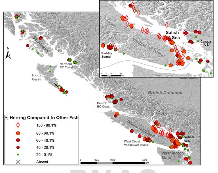
Pacific herring, killer whales, and pink salmon were species that were extensively studied following the Exxon Valdez spill and were discussed by numerous participants in the Panel’s process.

As referred to by the Haisla Nation, Pacific herring are listed as “not recovering” by the Exxon Valdez Oil Spill Trustee Council. The Trustee Council said that, despite numerous studies to understand the effects of oil on herring, the causes constraining population recovery are not well understood.

Northern Gateway said that scientific evidence indicates that a combination of factors, including disease, nutrition, predation, and poor recruitment
appear to have contributed to the continued suppression of herring populations in Prince William Sound.

Northern Gateway said that 20 years of research on herring suggests that the Exxon Valdez oil spill is likely to have initially had localized effects on herring eggs and larvae, without causing effects at the population level. Northern Gateway said
that, even after 20 years, the effects of the spill on herring remain uncertain. It said that there has also been convergence amongst researchers that herring declines in the spill area cannot be connected to the spill.

Northern Gateway said that herring stocks along the entire coast of British
Columbia have been in overall decline for  years and that herring were shown to recover within 1 to 2 years following the Nestucca barge spill.

A Gitxaala Nation expert noted the uncertainty in interpreting the decline of herring following the Exxon Valdez oil spill and said that the debate is not likely to ever be settled.

The Living Oceans Society said that the Exxon Valdez Oil Spill Trustee Council reported that some killer whale groups suffered long-term damage from initial exposure to the spill. Northern Gateway’s expert said the research leads him to
conclude that the actual effects on killer whales of the Exxon Valdez spill are unknowable due to numerous confounding factors. He said that the
Exxon Valdez Oil Spill Trustee Council has not definitively said that killer whale mortalities can be attributed to the spill. A Government of Canada
expert said that the weight of evidence suggests that the mortality of killer whales was most likely related to the spill.

Northern Gateway said that mass mortality of marine fish following a spill is rare. In response to questions from the Haisla Nation, Northern Gateway said that fish have the ability to metabolize potentially toxic substances such as polycyclic aromatic hydrocarbons. It said that international experience with oil spills has demonstrated that fin fishery closures tend to be very short in duration.
Northern Gateway said that food safety programs for fin fish conducted following the Exxon Valdez spill and the Selendang Ayu spill in Alaska indicated
that the finfish were not affected by the spill and that the fish were found, through food safety testing programs, to be safe to eat.

The Haisla Nation referred to the Exxon Valdez Oil Spill Trustee Council report that discussed the complexities and uncertainties in the recovery status of pink salmon. It said that, by 1999, pink salmon were listed as recovered and that the
report noted that continuing exposure of embryos to lingering oil is negligible and unlikely to limit populations.

Northern Gateway said that the longterm effect of the spill on pink salmon survival is
best demonstrated by the success of adult returns following the spill. Northern Gateway said that, in the month following the spill, when there was still
free oil throughout Prince William Sound, hundreds of millions of natural and hatchery pink salmon fry migrated through the area. It argued that these fish would arguably be at greatest risk from spill-related effects but that the adult returns 2 years later were one of the highest populations ever. Northern Gateway said that sockeye and pink salmon appear to have been unaffected by the Exxon Valdez spill
over the long term.

In response to questions from the Council of the Haida Nation and the United Fishermen and Allied Workers Union, Northern Gateway said that effects
on species such as seaweed, crabs, and clams have been shown to be relatively short-term, with these species typically recovering within 2 years or less
following a spill, depending on circumstances.

Northern Gateway said that, based on the Exxon Valdez spill, the level of hydrocarbons dissolved or suspended in the water column would be expected
to be substantially lower than those for which potential toxic effects on crabs or fish may occur.

In response to questions from BC Nature and Nature Canada, Northern Gateway said that the Exxon Valdez oil spill indicates which species of birds are most susceptible to oiling. Seabirds are generally vulnerable to oil spills because many species spend large amounts of time at sea. Diving seabirds such as murres are particularly vulnerable to oiling because they spend most of their time on the surface, where oil is found, and tend to raft  together. Thus, these species often account for most of the bird mortality associated with oil spills.

More than 30,000 seabird carcasses, of which 74 per cent were murres, were recovered following the Exxon Valdez spill and it was initially estimated
that between 100,000 and 300,000 seabirds were killed. However, detailed surveys of breeding murres in 1991 indicated no overall difference from pre-spill levels confirming rapid recovery of this species.

Northern Gateway said that, although potential toxicological effects from oil spills on
birds have been well documented in laboratory studies, the ultimate measure of recovery potential is how quickly birds return to their natural abundance and reproductive performance. It said that recovery is often difficult to measure due to
significant natural variation in populations and the fact that the baseline is often disputed. It said that this can lead to misinterpretation of results depicting recovery.

At the request of Environment Canada, Northern Gateway filed two reports on the susceptibility of marine birds to oil and the acute and chronic effects of the Exxon Valdez oil spill on marine birds. Northern Gateway said that marine birds are
vulnerable to oil in several ways such as contact, direct or indirect ingestion, and loss of habitat.
It said that many marine bird populations appear to have recovered from the effects of the Exxon Valdez spill, but some species such as harlequin ducks and pigeon guillemots have not recovered, according to the Exxon Valdez Oil Spill Trustee
Council. It said these reports demonstrate that marine birds are susceptible to marine oil spills to varying degrees depending on the species, its life
history and habitat, and circumstances associated with the spill.
Northern Gateway concluded that:
• Marine, freshwater, and terrestrial environments recover from oil spills, with recovery time influenced by the environment, the valued ecosystem components of interest, and other factors such as spill volume and characteristics
of the oil. Depending on the species and circumstances, recovery can be quite rapid or it can range from 2 to 20 years. Other scientific reviews have indicated that recovery of marine environments from oil spills takes 2 to 10 years.
• Different marine ecosystem components recover at different rates. Recovery time can range from days or weeks in the case of water quality, to years or decades for sheltered, soft sediment marshes. Headlands and exposed rocky shores can take 1 to 4 years to recover.
• Little to no oil remained on the shoreline after 3 years for the vast majority of shoreline oiled following the Exxon Valdez spill,
• The Exxon Valdez Oil Spill Trustee Council concluded that, after 20 years, any remaining Exxon Valdez oil in subtidal sediment is no longer a concern, and that subtidal communities are very likely to have recovered.
• Because sheltered habitats have long recovery times, modern spill response gives high priority to preventing oil from entering marshes and other protected shoreline areas.
• Valued ecosystem components with short life spans can recover relatively rapidly, within days to a few years. Recovery is faster when there is an abundant supply of propagules close to the affected area. For example, drifting larvae from
un-oiled marine and freshwater habitats will rapidly repopulate nearby areas affected by a spill.
• Plankton recovery is typically very rapid.
• Seabed organisms such as filter feeders may be subject to acute effects for several years, depending on location, environmental conditions, and degree of oiling.
• Marine fisheries and other human harvesting activities appear to recover within about 2 to 5 years if the resource has recovered and has not been affected by factors other than the oil spill.
• Protracted litigation may delay resumption of fisheries and other harvesting.
• Local community involvement in spill response priorities and mitigation plans can reduce community impacts and speed recovery of
fisheries and harvesting activities.
• A long life span typically means a long recovery time, in the case of bird and mammal populations that can only recover by local reproduction rather
than by immigration from other areas.
• Fast moving rivers and streams tend to recover more quickly than slow flowing watercourses, due to dispersal of oil into the water column by turbulence, which can enhance dissolution, evaporation, and microbial degradation.
• Drinking water and other water uses can be affected by an oil spill for weeks to months. Drinking water advisories are usually issued. Groundwater use may be restricted for periods ranging from a few weeks to 2 years, depending on
the type of use.

• Groundwater can take years to decades to recover if oil reaches it. Groundwater does not appear to have been affected in the case of Enbridge’s Kalamazoo River spill, near Marshall, Michigan.

• Freshwater invertebrates appear to have recovered within 2 years in several cases.
• Freshwater fisheries may recover fully in as little as four years, with signs of partial recovery evident after only a few months. The ban on consumption of fish in the Kalamazoo River was to be lifted approximately two years following
the spill.
• Human activities are affected by factors such as cleanup activities, safety closures and harvesting bans. These typically persist for months to a few years.
• Appropriate cleanup can promote recovery, while inappropriate cleanup techniques can actually increase biophysical recovery time.
Modern spill response procedures carefully consider the most appropriate treatment for the oil type, level of contamination, and habitat type.
The Living Oceans Society noted the following in relation to potential recovery of the marine environment following a spill:
• Physical contamination and smothering are primary mechanisms that adversely affect marine life, particularly intertidal organisms.
• Birds and mammals suffer the greatest acute impact when exposed to oil at or near the water surface.
• Marine communities have variable resiliency to oil spills, from highly tolerant (plankton, kelp beds), to very intolerant (estuaries and sea otters). Impacts to communities and populations are very difficult to measure due
to lack of scientific methods to measure long term,sublethal, and chronic ecological impacts.
• As the return of the marine environment to the precise conditions that preceded the oil spill is unlikely, a measurement of spill recovery can be
based on a comparison of un-oiled sites with oiled sites of similar ecological characteristics.
• The Exxon Valdez oil spill killed many birds and sea otters. Population-level impacts to salmon, sea otters, harbour seals, and sea birds appear to have been low. Wildlife populations had recovered within their natural range of variability after 12 years.
• Intertidal habitats of Prince William Sound have shown surprisingly good recovery. Many shorelines that were heavily oiled and then cleaned appear much as they did before the spill. There is still residual buried oil on some beaches. Some mussel and clam beds have not fully recovered.
• The marine environment recovered with little intervention beyond initial cleaning. Natural flushing by waves and storms can be more effective than human intervention.
• Wildlife rescue and rehabilitation efforts had a marginal beneficial effect on the recovery of bird and mammal populations
• The impacted area of Prince William Sound had shown surprising resiliency and an ability to return to its natural state within the range of natural variability.
• The Exxon Valdez oil spill had significant and long-lasting effects on people and communities.

Questioning experts

The Panel posed a series of questions to experts representing Northern Gateway, federal government participants, and the Gitxaala First Nation regarding the potential recovery of marine ecosystems following a large oil spill.
Northern Gateway said that past marine spills have demonstrated that, over time, the environment will recover to a pre-spill state, and that most species fully recover. It said that species associated with the surface of the water tend to be most susceptible to oil spills, and that cleanup efforts can help direct and
accelerate natural restoration processes.
Federal government experts generally agreed with Northern Gateway’s responses, although they stressed that effects could be felt in areas other than the water surface, such as intertidal and subtidal zones. They said that it is difficult to define
and assess effects and recovery, depending on the species and availability of baseline information.
They said that most species may fully recover over time, and that the time frame for this recovery can be extremely variable depending on species and circumstances.
The Gitxaala Nation’s experts noted the potential for effects on species at the water surface and in intertidal areas, and noted exceptions to the notion that
the marine environment will naturally restore itself.
They said that full recovery can occur, depending on the circumstances, but is not guaranteed. They said that it is difficult to assess spill effects in the absence
of adequate baseline information.


Despite the quarter century of studies on the Exxon Valdez inicident, the paucity of studies prior to the spill mean that arguments will continue over “baseline information.”

Participants told the Panel that a lack of baseline information has often made it difficult to separate spill-related effects from those that were caused by natural variation or other causes not related to a spill.

Northern Gateway acknowledged the need for adequate baseline information. Parties such as Coastal First Nations, Raincoast Conservation Foundation, and the Gitxaala Nation said that Northern Gateway had provided insufficient baseline information to assess future spill-related effects. The Kitsumkalum First Nation asked how
spill-related effects on traditionally harvested foods could be assessed in the absence of baseline information.

The Haisla Nation noted the importance of collecting baseline data in the Kitimat River valley to compare with construction and spill-related impacts. The Haisla Nation submitted a report outlining important considerations for a baseline
monitoring program. One recommendation was that the program should engage stakeholders and be proponent-funded. In response to questions
from Northern Gateway, the Haisla Nation noted that a design along the lines of a before/after control/impact model would be appropriate.

In response to these comments, Northern Gateway noted its commitment to implement a Pipeline Environmental Effects Monitoring Program. Northern Gateway’s
proposed framework for the monitoring program indicates that a number of water column, sediment, and biological indicators would be monitored.
The Raincoast Conservation Foundation said that one of the principal lessons learned from the Exxon Valdez oil spill was the importance of collecting abundance and distribution data for non-commercial species. Because baseline information was
lacking, spill effects on coastal wildlife were difficult to determine. Environment Canada also noted the importance of adequate baseline information to
assess, for example, spill-related effects on marine birds.

Northern Gateway outlined the baseline measurements that it had already conducted as part of its environmental assessment. It also said that is
would implement a Marine Environmental Effects Monitoring Program. Northern Gateway said that the initial baseline data, plus ongoing monitoring,
would create a good baseline for environmental quality and the abundance, distribution, and diversity of marine biota. In the event of an oil spill
it would also help inform decisions about restoration endpoints.

Northern Gateway said that it would provide Aboriginal groups with the opportunity to undertake baseline harvesting studies. In response to questions from the United Fishermen and Allied Workers Union, Northern Gateway said that baseline information gathered through the environmental effects monitoring program would also be relevant to commercial harvest management and for assessing compensation claims in the event of a spill.
The Kitimat Valley Naturalists noted the ecological importance of the Kitimat River estuary.

The Joint Review Panel, in its conclusions and ruling, generally agreed with the energy industry that affects of a major oil spill would be temporary.

The Panel heard evidence and opinion regarding the value that the public and Aboriginal groups place on a healthy natural environment.

The Panel finds that it is not able to quantify how a spill could affect people’s values and perceptions.
The Panel finds that any large spill would have short-term negative effects on people’s values, perceptions and sense of wellbeing.

The Panel is of the view that implementation of appropriate mitigation and compensation following a spill would lessen these effects over time. The
Panel heard that protracted litigation can delay recovery of the human environment.

The Panel heard that appropriate engagement of communities in determining spill response priorities and developing community mitigation plans can also lessen effects on communities. Northern Gateway has committed to the development
of Community Response Plans
The Panel’s finding regarding ecosystem recovery following a large spill is based on extensive scientific evidence filed by many parties, including information on recovery of the environment from large past spill events such as the Exxon Valdez
oil spill. The Panel notes that different parties sometimes referred to the same studies on environmental recovery after oil spills, and drew different conclusions. In its consideration of natural recovery of the environment, the Panel focused
on effects that are more readily measurable such as population level impacts, harvest levels, or established environmental quality criteria such as
water and sediment quality criteria.
The Panel finds that the evidence indicates that ecosystems will recover over time after a spill and that the post-spill ecosystem will share functional attributes of the pre-spill one. Postspill ecosystems may not be identical to pre-spill ecosystems. Certain ecosystem components may continue to show effects, and residual oil
may remain in some locations. In certain unlikely circumstances, the Panel finds that a localized population or species could potentially be permanently affected by an oil spill. Scientific studies after the Exxon Valdez spill indicated that the vast majority of species recovered following the spill and that functioning ecosystems, similar
to those existing pre-spill, were established.
Species for which recovery is not fully apparent, such as Pacific herring, killer whales, and pigeon guillemots, appear to have been affected by other
environmental factors or human influences not associated with the oil spill. Insufficient pre-spill baseline data on these species contributed to
difficulties in determining the extent of spill effects.
Based on the evidence, the Panel finds that natural recovery of the aquatic environment after an oil spill is likely to be the primary recovery
mechanism, particularly for marine spills. Both freshwater and marine ecosystem recovery is further mitigated where cleanup is possible, effective, and beneficial to the environment.
Natural processes that degrade oil would begin immediately following a spill. Although residual oil could remain buried in sediments for years, the Panel finds that toxicity associated with that oil would decline over time and would not cause
widespread, long-term impacts.

The Panel finds that Northern Gateway’s commitment to use human interventions,
including available spill response technologies, would mitigate spill impacts to ecosystems and assist in species recovery. Many parties expressed concerns about potential short-term and long-term spill effects on resources that they use or depend on, such as drinking water, clams, herring, seaweed, and fish. The weight of
evidence indicates that these resources recover relatively rapidly following a large oil spill.

For example, following the Selendang Ayu and Exxon Valdez spills in Alaska, fin fish were found, through food safety testing programs, to be safe to eat. Food safety closures for species such as mussels, urchins, and crabs were lifted within 1 to
2 years following the spills.
The actual time frame for recovery would depend on the circumstances of the spill. Until harvestable resources recover, various measures are typically put in place, such as compensation,harvest restrictions or closures, and provision of
alternative supply.
It is difficult to define recovery of the human environment because people’s perceptions and values are involved. This was made clear to the
Panel through oral statements and oral evidence.
The Panel finds that oil spills would cause disruptions in people’s lives, especially those people who depend on the marine environment for sustenance, commercial activities and other uses. The extent and magnitude of this disruption
would depend on the specific circumstances associated with the spill. The Panel views recovery of the socio-economic environment as the time when immediate impacts and interruption to people’s lives are no longer evident, and the
natural resources upon which people depend are available for use and consumption.
The Panel heard that assessing the potential recovery time of the environment is often complicated by challenges in separating background or unrelated events from spill-related effects. There can be natural variation in species populations,
and other natural and human-induced effects can also make it difficult to determine which impacts are spill-related and which are not.
The Panel notes that Northern Gateway has committed to collect baseline data and gather baseline information on harvest levels and values through initiatives such as its Environmental Effects Monitoring Program, Fisheries Liaison
Committee, and traditional harvest studies. The Panel finds that these commitments go beyond regulatory requirements and are necessary. This information would contribute to assessments of spill effects on resource harvesting values,
post-spill environmental recovery, and loss and liability determinations.
The Panel is of the view that it is not possible to predict a specific time in which overall recovery of the environment may occur. The time for recovery would depend on the type and volume of product spilled, environmental conditions,
the success of oil spill response and cleanup measures, and the extent of exposure of living and non-living components of the environment to the product spilled. Recovery of living and non-living components of the environment would
occur over different time frames ranging from weeks, to years, and in the extreme, decades.
Even within the same environmental component, recovery may occur over different time frames depending on local factors such as geographic location, the amount of oiling, success of cleanup, and amount of natural degradation.
Based on the physical and chemical characteristics described for the diluted bitumen to be shipped and the fate and transport modelling conducted, the Panel finds that stranded oil on shorelines would not be uniformly distributed on
shorelines and that heavy oiling would be limited to specific shoreline areas. The Panel accepts Northern Gateway’s prediction that spilled dilbit could persist longer in sheltered areas, resulting in longer consumption advisories for intertidal
communities and associated invertebrates than in more open areas.

Based on the scientific evidence, the Panel accepts the results of the
chronic risk assessment that predicted no significant risks to marine life due to oil deposition in the subtidal sediments.
For potential terrestrial and marine spills, the Panel does not view reversibility as a reasonable measure against which to predict ecosystem recovery. No ecosystem is static and it is unlikely that an ecosystem will return to exactly the same
state following any natural or human induced disruption. Based on the evidence and the Panel’s technical expertise, it has evaluated whether or not functioning ecosystems are likely to return after a spill. Requiring Northern Gateway to
collect baseline data would provide important information to compare ecosystem functions before and after any potential spill.

The Panel finds that Northern Gateway’s ecological and human health risk assessment models and techniques were conducted using conservative assumptions and state of the art models. Combined with information from past spill events, these assessments provided sufficient information to inform the Panel’s deliberation on
the extent and severity of potential environmental effects. The Panel finds that this knowledge was incorporated in Northern Gateway’s spill prevention strategies and spill preparedness and response planning. Although the ecological risk assessment
models used by Northern Gateway may not replicate all possible environmental conditions or effects, the spill simulations conducted by Northern Gateway provided a useful indication of the potential range of consequences of large oil spills in
complex natural environments.

First Nations historical herring harvest offers “deep time perspective” to modern managers, SFU study says

SFU archaeologists
Iain McKechnie and Dana Lepofsky examine ancient herring fish bones that tell the story about how gigantic herring fisheries were for thousands of years in the Pacific Northwest. (SFU)

The herring, now dwindling on on the Pacific Coast, was once “superabundant” from Washington State through British Columbia to Alaska and that is a warning for the future, a new study says.

A team of scientists lead by Simon Fraser University argue that the archaeological record on the Pacific Coast offers a “deep time perspective” going back ten thousand years that can be a guide for future management of the herring and other fish species.

An archaeological study looked at 171 First Nations’ sites from Washington to Alaska and recovered and analyzed 435,777 fish bones from various species.

Herring bones were the most abundant and dating shows that herring abundance can be traced from about 10,700 years ago to about the mid-nineteenth century with the arrival of Europeans and the adoption of industrial harvesting methods by both settlers and some First Nations.

That means herring were perhaps the greatest food source for First Nations for ten thousand years surpassing the “iconic salmon.” Herring bones were the most frequent at 56 per cent of the sites surveyed and made up for 49 per cent of the bones at sites overall.

The study was published online Monday, February 17, 2014, in Proceedings of the National Academy of Sciences (PNAS). Simon Fraser University researchers Iain McKechnie, Dana Lepofsky and Ken Lertzman, and scientists in Ontario, Alberta and the United States are its co-authors.

The study is one of many initiatives of the SFU-based Herring School, a group of researchers that investigates the cultural and ecological importance of herring.

“By compiling the largest data set of archaeological fish bones in the Pacific Northwest Coast, we demonstrate the value of using such data to establish an ecological baseline for modern fisheries,” says Iain McKechnie. The SFU archaeology postdoctoral fellow is the study’s lead author and a recent University of British Columbia graduate.

Co-author and SFU archaeology professor Dana Lepofsky states: “Our archaeological findings fit well with what First Nations have been telling us. Herring have always played a central role in the social and economic lives of coastal communities. Archaeology, combined with oral traditions, is a powerful tool for understanding coastal ecology prior to industrial development.”

The researchers drew from their ancient data-catch concrete evidence that long-ago herring populations were consistently abundant and widespread for thousands of years. This contrasts dramatically with today’s dwindling and erratic herring numbers.

“This kind of ecological baseline extends into the past well beyond the era of industrial fisheries. It is critical for understanding the ecological and cultural basis of coastal fisheries and designing sustainable management systems today,” says Ken Lertzman, another SFU co-author. The SFU School of Resource and Environmental Management professor directs the Hakai Network for Coastal People, Ecosystems and Management.

Map of First Nations sites with fish bones
Map of First Nations’ archaeological sites with high numbers of fish bones. Herring is abundant in sites throughout the Strait of Georgia. In 71% of sites, herring makes up at least 20 per cent of the bones found at the site. (SFU/PNAS)

Heiltsuk tradition

The paper says that the abundance of herring is additionally mirrored in First Nations’ place
names and origin narratives. They give the example of the 2,400-y-old site at Nulu where herring
made up about 85 per cent of the fish found in local middens. In Heiltsuk oral tradition, it is Nulu where Raven first found herring. Another site, 25 kilometres away at the Koeye River, has only has about 10 per cent herring remains and is not associated with herring in Heiltsuk tradition.

(In an e-mail to Northwest Coast Energy News, McKechnie said “there is a paucity of archaeological data from Kitimat and Douglas Channel. There is considerable data from around Prince Rupert, the Dundas Islands and on the central coast Namu/Bella Bella/ Rivers Inlet area and in southern Haida Gwaii.”)

The study says that the archaeological record indicates that places with abundant herring were consistently harvested over time, and suggests that the areas where herring massed or spawned were more extensive and less variable in the past than today. It says that even if there were natural variations in the herring population, the First Nations harvest did not affect the species overall.

It notes:

Many coastal groups maintained family-owned locations for harvesting herring and herring roe from anchored kelp fronds, eel grass, or boughs of hemlock or cedar trees. Herring was harvested at other times of the year than the spawning period when massing in local waters but most ethnohistorical observations identify late winter and springtime spawning as a key period of harvest for both roe and fish.

The herring and herring roe were either consumed or traded among the First Nations.

Sustainable harvests encouraged by building kelp gardens,wherein some roe covered fronds were not collected, by minimizing noise and movement during spawning events, and by elaborate systems of kin-based rights and responsibilities that regulated herring use and distribution.

Industrial harvesting

Industrial harvesting and widespread consumption changed all that. Large numbers of herring were harvested to for rendering to oil or meal. By 1910, the problem was already becoming clear. In that year British Columbia prohibited the reduction of herring for oil and fertilizer. There were reports at that time that larger bays on the Lower Mainland were “being gradually deserted by the larger schools where they were formerly easily obtained.”

But harvesting continued, in 1927 the fishery on eastern Vancouver Island, Columbia, processed
31,103 tons of herring. The SFU study notes that that is roughly twice the harvest rate for 2012 and would also be about 38 per cent of the current herring biomass in the Strait of Georgia.
In Alaska, reduction of herring began in 1882 and reached a peak of 75,000 tons in 1929.

As the coastal populations dwindled, as with other fisheries, the emphasis moved to deeper water. By the 1960s, the herring populations of British Columbia and Washington had collapsed. Canada banned herring reduction entirely in 1968, Washington followed in the early 1980s.

In the 1970s, the herring population off Japan collapsed, which opened up the demand for North American roe, which targeted female herring as they were ready to spawn. That further reduced the herring population so that the roe fishery is now limited to just a few areas including parts of the Salish Sea and off Sitka and Togiak, Alaska.

The First Nations food, social and ceremonial herring fishery continues.

Government fishery managers, scientists, and local and indigenous peoples lack consensus on the cumulative consequences of ongoing commercial fisheries on herring populations. Many First Nations, Native Americans, Alaska Natives, and other local fishers, based on personal observations and traditional knowledge, hypothesize that local herring stocks, on which they consistently relied for generations, have been dramatically reduced and made more difficult to access following 20th century industrial fishing

Deep time perspective

The SFU study says that some fisheries managers are suggesting that the herring population has just shifted to other locations and other causes may be climate change and the redounding of predator populations.

But the study concludes, that:

Our data support the idea that if past populations of Pacific herring exhibited substantial variability, then this variability was expressed around a high enough mean abundance such that there was adequate herring available for indigenous fishers to sustain their harvests but avoid the extirpation of local populations.

These records thus demonstrate a fishery that was sustainable at local and regional scales over millennia, and a resilient relationship between harvesters, herring, and environmental change that has been absent in the modern era.

Archaeological data have the potential to provide a deep time perspective on the interaction between humans and the resources on which they depend.

Furthermore, the data can contribute significantly toward developing temporally meaningful ecological baselines that avoid the biases of shorter-term records.

Other universities participating in the study were the University of British Columbia, University of Oregon, Portland State University, Lakehead University, University of Toronto, Rutgers University and the University of Alberta.


RELATED:

BC First Nations Opposition to Commercial Herring Fisheries supported by DFO

Fisheries minister ignored advice from own scientists

Oil spill caused “unexpected lethal impact” on herring, study shows

Bitumen excluded from data for federal tanker study, documents reveal

Tanker risk map
Transport Canada tanker report map shows current risk for spills in BC (Transport Canada)


Genivar report
Cover of Genivar tanker report (Transport Canada)


The possible effects of a bitumen spill on Pacific waters were not considered in the oil response preparedness report released last week by the Harper government, the background data study reveals.

The consulting firm that did the study for Transport Canada, Genivar Inc, had no reliable data on the effect of a bitumen tanker disaster—because, so far, there has been no major ocean disaster involving diluted bitumen.

Instead, Genivar, based its findings on potential hazards and response on existing data on crude oil spills.

The Genivar study, however, does warn, that if the Enbridge Northern Gateway project does go ahead,  the spill risk from diluted bitumen carrying tankers in Douglas Channel and along the north Pacific coast will jump from “low” or “medium” to “very high.” If the twinning of the Kinder Morgan pipeline goes ahead, then the risk in Vancouver also jumps to “very high.”

The question of how bitumen might behave in the cold and choppy waters of the North Pacific was hotly debated during the Northern Gateway Joint Review hearings earlier this year. Enbridge Northern Gateway based its position on laboratory studies, studies that were challenged by environmental and First Nations intervenors, pointing both to the unknowns of the ocean environment and the continuing problems Enbridge has in cleaning up the spill in the Kalamazoo River in Michigan.

Genivar tried to base its report to Transport Canada on existing data on oil spills and related hazards. What it found instead is that that there are often gaping holes in the reporting and monitoring of oil spills world wide, especially small and medium sized spills.

Lack of data also meant that Genivar had little to go on when it calculated the effect on an oil spill on key areas of interest to northwest British Columbia, the recreational fishery and tourism.
Genivar, however, did uncover disturbing data about the long term effects of oil spills, studies that show even minute amounts of remaining oil can still disrupt the marine environment 40 years after an event.

The Genivar report, Risk Assessment for Marine Spills in Canadian Waters Phase 1: Oil Spills South of 60th Parallel, was completed in November, then passed on to the “expert panel” that released their own report: A Review of Canada’s Ship-source Oil Spill Preparedness and Response Regime — Setting the Course for the Future. That second report was based not only on the data provided by Genivar but on the expertise of three panel members, their visits to some locations and input from government, industry, First Nations and municipalities.

Transport Minister Lisa Raitt and Natural Resources Minister Joe Oliver unveiled the second report at a glitzy media event  in Vancouver on Tuesday, December 10. At that time the expert panel report was released to the media along with an abstract of the data.

The actual data report was not posted; it had to be requested through the Transport Canada website, which is how Northwest Coast Energy News obtained the background study.

High risk for Kitimat

Transport Canada tanker report
Expert panel tanker risk assessment report cover (Transport Canada)

The expert panel found “a very high risk” of oil spills in two areas of the Pacific Coast, in the north around the ports of Kitimat and Prince Rupert and in the heavy ocean traffic area of southern British Columbia, especially Port Metro Vancouver and into Washington State.

The expert panel made 45 recommendations that covered a wide range of issues including eliminating the present $161-million liability limit for each spill and replacing it with unlimited liability for polluters, annual spill training involving the Canadian Coast Guard, Environment Canada, provincial and local authorities and the private sector, increased and improved annual spill training exercises, basing risk assessment on local geography and conditions and faster emergency responses to spills.

The expert panel calls for greatly increased research on the ocean environment at a time that Harper government has been gutting environmental research across Canada, while spinning that its policies are “science based.”

The science and technology around both the movement of oil and spill response has advanced significantly over the past several decades. We feel that while some aspects of the Regime have kept pace with these developments, in some areas, Canada has fallen behind world-leading countries like Norway and France. This can be attributed to a general lack of investment in research and development as well as the lack of coordination between industry and government over research priorities.

The Government of Canada should work closely with industry to establish a national research and development program for oil spill preparedness and response. The program should be co-funded by industry and the Government, and the research priorities should be set through a collaborative process that involves academia, where possible. Like the Regime itself, we view this program as a partnership between industry and government.

We envision that this program would also seek to leverage the work being done internationally on oil spill preparedness and response. The program should seek to establish partnerships with other world-leading countries in order to stay current on international advances and new technologies.

The expert panel, however, does not say how the federal government is expected to pay for meeting BC Premier Christy Clark’s condition for a “world class” spill prevention and response system at a time that Finance Minister Jim Flaherty is determined to balance the budget and the Harper government is continuing to cut back government services.

Bitumen excluded

On bitumen, the Genivar data study says:

Modified bitumen products represent the majority of the “crude carried as cargo” in
Pacific sub-sector 5. They are not modelled as a separate category in this spill behaviour analysis but are represented as “persistent crude”.

Changes in spill behaviour depend to some extent on the environmental conditions at the time of the spill, as described in greater detail below. However, over the range of wind and sea conditions typically experienced in the Canadian marine environment, changes in oil properties are not overly sensitive to variations in climatic values, so a single set of wind and sea conditions will be used in the analysis.

The idea that “changes in oil properties” not being sensitive to variations in climate was also frequently challenged before the Joint Review Panel.

On the increase in traffic volume if the Northern Gateway project goes ahead, the Genivar report says.

Enbridge Inc. has proposed to construct a marine terminal at Kitimat, B.C. and a dual pipeline from the terminal to oil sands production in northern Alberta. The terminal would handle up to 193,000 barrels/day of imported diluents (i.e., low-gravity condensate) that would be piped to Alberta and used to dilute bitumen to enhance its flow properties. The diluted bitumen would then be piped to Kitimat at rates up to 525,000 barrels/day that would be shipped by tanker to export to markets in Asia and California.

At full capacity, the import of diluent and export of diluted bitumen would total up to 35 Mt/year. This amount is comparable to the currently-shipped volume in the Pacific sector related to volumes being exported from Vancouver and related to volumes being exported from the Alaskan to Washington State trade.

It goes on to say that the current tanker traffic on the north Pacific coast “has negligible risk in the near shore and intermediate zones, but significant potential spill frequency in the deep-sea zone related to the Alaskan trade.” Similarly, according to Genivar the environmental risk in the region “currently ranges from ‘medium’ to “very low” from near shore to deep-sea zones, respectively…. mainly driven by a combination of physical and biological features.”

The increase in traffic from Northern Gateway would likely increase the environmental risks. The the near shore risk from would jump from “very low” to “very high.” For the largest spill category, deep-sea risk would likely increase from “low” to “medium.”

No data on recreational or traditional First Nations fishery

To study the effect on an oil spill on the fishery, Genivar used data from the Department of Fisheries and Oceans as the provinces to gauge “the port value of commercial fishing and the value of the fish, shellfish and aquaculture” in each zone it studied and then compared it to the the national averages for commercial fishery. Those figures included any commercial fishery by First Nations.

But Genivar noted, there is no reliable data on either the recreational fishery or the First Nations traditional, food, social and ceremonial fishery, saying:

It is important to highlight that this indicator does not consider recreational or traditional fishing. The importance of this industry is notable and an oil spill could damage the recreational fishing stock as well. However, the absence of comparable data and the fact that this study is restricted to federal and international data, and some provincial data from Quebec and Ontario for commercial fisheries, limits the ability to include recreational fishing… Nevertheless, as an absolute index, it will provide an overall vulnerability in the event of an oil spill.

The ongoing impact of cutbacks at Fisheries and Oceans has had a continuing impact on the northwest, especially in the controversial halibut recreational fishery, where DFO has admitted that it is basically guessing the size of each year’s recreational halibut catch.

Tourism

Genivar also notes that lack of reliable data on the effect on a oil spill on tourism. The consultants go so far as to say one of the indicators they will use to measure the effect of any oil spill on tourism would come from “data extracted from the 2011 National Household Survey at the census division level and the accommodation and food services data will be used.”

The “National Household Survey” is also known as the long form census and it is the National Household Survey that the Harper government made voluntary rather mandatory, decreasing the reliability of the data. Global News recently analyzed those who had contributed to the survey and found that it poor people, the very rich and people in low population areas were least likely to fill out the voluntary census—which means the data for northwest BC is likely highly unreliable from the 2011 survey even though “The census divisions in coastal regions will be selected for each of the sub-sectors. This method will express the economic vulnerability of each sub-sector to a potential collapse in tourism following a spill.”

Despite the importance of cruise ship traffic on the west coast, Genivar notes, “In Canada, data for passenger vessels were unavailable.”

It also notes that “this study does not specifically take into account national parks and other landmarks, since their influence on tourism is indirectly included in the tourism employment
intensity index” so that Genivar could create what it calls the Human-Use Resource Index (HRI), even though that index appears to be based on incomplete data.

Kitimat to issue tsunami hazard and evacuation map

Teron Moore explaining a tsunami
Teron Moore of Emergency Management explains a surge tsunami at a emergency preparedness forum at Riverlodge, Nov. 4, 2013 (Robin Rowland/Northwest Coast Energy News)

The District of Kitimat plans to issue a tsunami hazard and evacuation map for the town.

Fire Chief Trent Bossance and Emergency Coordinator Bob McLeod told a forum on emergency preparedness on November 4 that the map is in the final stages of preparation and will be distributed to residents in the near future.

The forum was also told that the former District Council Chambers on the second floor of the public safety building (the fire hall) is being converted into “a fixed, permanent emergency operations centre,” with upgraded communications and computer equipment.

McLeod said that over the past months, since the October 27, 2012 Haida Gwaii earthquake and the January 31, 2013, Sitka, Alaska earthquake, Kitimat’s emergency planners have been working with the province to update the original emergency plan which was first developed about 12 years ago.

McLeod said that the plan was recently sent to a consultant who told Kitimat the overall plan only needed minor charges. Now, however, there is new emphasis on tsunami planning.

Fire Chief Bossance says emergency planners have been consulting with scientists who have concluded that if a tsunami was to come into Kitimat from Douglas Channel, it most likely would be between two and four metres, so to be on the safe side, the District is planning on a “six metre baseline” from the high tide line. That means the hazard map will be based on the possibility of a six metre tsunami coming up the Channel. ( A worst case scenario, however, could result in a bigger tsunami, perhaps eight metres).

The forum at Riverlodge was part of an effort by both federal and provincial officials to visit communities that were affected by the two recent major earthquakes, inform local residents of updated planning by the federal government and British Columbia and to let those officials know what local concerns are.

Weather warnings
Anne McCarthy of Environment Canada explains that tsunami warnings on the Environment Canada website will be similar to weather warnings. Weather radios can be seen on the table in the foreground. (Robin Rowland/Northwest Coast Energy News)

Anne McCarthy of Environment Canada says her agency is planning to expand the Weather Radio system, most popular in Tornado Alley in the United States, to the northwest coast. There are already Weather Radio transmitters in the Lower Mainland. Kitimat, however, at this point, is low on the priority list, with Prince Rupert and then Sandspit and Masset roll outs in the coming year.

Environment Canada also plans to implement a Twitter feed sometime in 2014, that would supplement other Twitter feeds from Emergency Planning BC and the recently renamed US National Tsunami Warning Center (formerly the Alaska and West Coast Tsunami Warning Center), operated by the US National Oceanic and Atmospheric Administration. Tsunami warnings will also be posted on the Environment Canada website in the same way weather and other alerts are posted.

Surge of water

If an earthquake-triggered tsunami was to strike Kitimat from Douglas Channel, it would not be the big waves seen in the movies and during the 2004 Southeast Asia tsunamis, Teron Moore, a seismic specialist with the BC Provincial Emergency Management said. Given the configuration of Douglas Channel and its many islands, a tsunami is more likely to be a “surge” of water.

“Tsunamis can appear like a rising tide that quickly keeps coming in, “ Moore said. “A normal tide would stop at the high tide line.Sometimes a tsunami can be a quickly rising tide that keeps on coming….A wave can come in for 30 minutes. it’s a long, long time that these waves just keep on coming in and you wouldn’t see the crest of a wave, necessarily and then they come out. So it’s almost like that river comes in for half an hour and then can go back out for half an hour. There’s a tendency for people first of all to not think it’s dangerous, A second, third and fourth wave can come in.”

Tsunami events can last as much as eight to twelve hours, Moore said. Depending on the location of the triggering earthquake, Kitimat is likely to have some warning of a possible incoming earthquake-triggered tsunami.

The second type of tsunami could be triggered by a submarine landslide in Douglas Channel, as happened with  slope failures in October 17, 1974 (triggering a 2.4 metre tsunami at low tide) and on April 27, 1975 (generating an 8.2 metre tsunami). The 1975 tsunami destroyed the Northland Navigation dock near Kitimat and damaged the Haisla First Nation docks at Kitamaat Village.

“The slide in 1975 generated an eight metre wave that came from Moon Bay across to Kitimat Village, now that is huge wave. We can’t really predict an event like that, it would happen so fast,” McLeod said.

Hazard areas

Two major fault lines could trigger shaking in Kitimat and might possibly also mean that there could be a tsunami.

The first is the Cascadia fault which goes from the northern California to the western edge of Vancouver Island. The second is the Queen Charlotte fault off Haida Gwaii.

The Cascadia fault, Moore said, is an active subduction zone. “A subduction zone is where two of earth’s large plates are colliding against each other and one of those plates is going under neath another one of those plates.’ The plates get stuck and build up strain “almost like pulling an elastic band. At sometime the elastic band snaps creating a very large earthquake,” Moore said.

The Juan de Fuca plate is a very large plate subducting underneath the continent of North American plate. The Juan de Fuca plate has been stuck for some 300 hundred years since the last time it ruptured. There is a rupture about every 500 years or so in this zone that triggers a large earthquake.

“But, Moore warned, “it’s 500 years plus or minus 200 years. even though there’s a lot of modelling doing on, there’s still a lot of uncertainty and so its a concept that it is difficult to get an understanding of.

“The Haida Gwaii or Queen Charlotte fault….is one that is going side by side. It’s called a strike slip fault. “A strike slip fault can still cause earthquakes it can still rupture and cause shaking, but if it doesn’t have that subduction, you tend to not have tsunamis. “Although science says the Charlotte fault has a low likely of causing a tsunami, but as we know from last year the Charlotte fault did cause a tsunami, quite a significant tsunami in some areas, not one that impacted Kitimat but one that could have impacted Kitimat and did impact, the west coast of Haida Gwaii quite significantly.

“We were very lucky there weren’t any large communities out there. We very lucky that it wasn’t at the height of summer tourist season with kayakers and fishing lodges. In some areas, the way the wave came into certain bays, created a five metre tsunami. “So if you were on the beach and a five metre tsunami was coming up the inlet, that’s a significant tsunami. What I want to emphasize is that people here who felt the shaking, they should have gone to high ground.”

Emergency procedures

In the case of a major earthquake, where residents of Kitimat feel shaking, then they should take appropriate precautions, the forum was told, including moving to higher ground if they think they should.

“Once the maps are available we will get them out to the public. I think it is important for the public to understand and visualize, where they sit within that six metre height. Always if you’re unsure go to higher ground. It’s easier to come back if your house is unaffected, than trying to leave if your house is being affected,” McLeod said.

There would be no reason to actually leave Kitimat, according to Emergency Management B.C.’s northwest regional manager Maurie Hurst. “Kitamaat Village should evacuate to higher ground. I would not like to see them coming down that coast highway to Kitimat, that’s not safe. Stay where you are, move to higher ground.

“At Sandspit higher ground is quite a ways a way from the community for them they are having to a bit of travel but in Kitimat higher ground is a ten minute walk, a five minute drive, it’s right here within the community.”

After an earthquake occurs, the National Tsunami Warning Center in Homer, Alaska evaluates the situation and sends out alerts to Canadian and US government agencies. In British Columbia, Emergency Management BC is the lead agency.

It communicates with Environment Canada, the Canadian Coast Guard, local emergency officials and the media. In Kitimat, it is the local emergency management officials and first responders who are in charge.

After misinformation went out over social media during the October 27, 2012 event, McLeod says the District of Kitimat now has social media specialists at the Emergency Operations Centre. “We’ve modified the district website, so there will be banners going up on it, just to get accurate information out.” Using the baseline of six metres above high tide, McLeod says the Rio Tinto Alcan wharfs, MK Bay Marina and the Kitamaat Village dock would most likely be affected.

While that means most of the Kitimat community may not be affected, there are other factors involved, according to Chief Bossance. “Because of all the islands we have in the waterways, we’re not going to have that big wave, we are going to have that surge,” he said.  “If a tsunami is coming, we always look at the earthquake, what was its magnitude, obviously the higher the magnitude, the more impact it’s going to have for everyone in that case.

Kitimat Fire Chief Trent Bossance
Kitimat Fire Chief Trent Bossance explains emergency procedures in case of a tsunami (Robin Rowland/Northwest Coast Energy News)

“We looked at seven point seven the most recent one, (on Haida Gwaii)it had very little impact here due the fact that it was a slip slide.

“The other fault, the one along Vancouver Island, is a different fault altogether. The problem we’re having with us right now, there haven’t been a lot studies conducted with how that waters going to impact coming from that direction into us.

“If it’s a significant shaking, don’t wait for us to tell you to go high ground.

“So they’re saying anywhere from two metres, depending on high tide up to four. We took the next step and said we’re going to go with six to build in a safety factor.

“But saying that, we have to know what our tide heights are at the time the tsunami strikes. The other thing we look at is the magnitude of the quake.

“So if you’re living down in the Kildala area and if we determine that it’s an eight metre event, then evacuation might be necessary.

“Everything is do dependent on what happens from the time of the earthquake, the tides, the weather. If we’re having significant rainfall at the time, that would mean the river would swell. If it’s the fall when we get our monsoons, that may change the fact of what’s going to happen.

“If you look at the dike, the dike is what is separating us from the river. Kitimat is sort of odd in that we have a dike that surrounds a lot of the town, but there’s an open spot in it, so it’s going to funnel through there and into the lower lying areas of the Kildala area.”

Under most circumstances, Bossance said, the City Centre Lower Parking lot would be above the danger zone.

“Just because we’re looking at six doesn’t mean it’s not going affect everyone, our plan is constantly evolving. Local officials are the ones to tell you it is safe to go back home.”

Boaters concerned

There was one question arose at the forum that the panelists had no immediate answer for. What should boaters do if there is a tsunami warning while they are on the Channel, especially during the summer or the peak salmon season when there could a hundred or so boats on the water?

“Douglas Channel is a deep channel,” Bossance said. “It’s in the shallow water and it builds, but here it is relativey deep water until it’s close to shore. That’s why it’s such a great deep sea port,its deep and then it shallows fairly quickly that’s why they’re saying we’re not going to have that big wave coming in., its going to be a surge of water.”

The panel they would investigate the situation further but at the moment they presume that it would be best to go the center of the channel. “The usually advice to make for open water that’s what the [US] coast guard recommends.”

A boaters safety brochure  issued by the State of California recommends getting to 100 fathoms or 600 feet.

A similar brochure from Hawaii recommends a minimum depth of 300 feet and staying clear of a harbour entrance channel during an event. The Hawaii brochure warns that if a boater is not on the water, they should not go down to their boats.

The brochure notes that: “In 1964 in Kodiak, Alaska, a warning was received prior to the arrival of the first tsunami waves. People who rushed down to the harbor to secure or take their boats out to sea constituted two thirds of all the fatalities caused by the tsunami at Kodiak City.” There is, so far, no similar brochure issued by the province of BC.

The panel suggested that a sign be posted at MK Bay, outlining safety procedures. Moore said: “The other thing we’re thinking about is there could be wave action for eight to ten to twelve hours maybe. If you need to  have eight to ten hours of gas to fight the current, eight to ten hours of food, all the things you’re going to need. There were cases in California where boats kept on idle to keep being driven into shore and then they run out of gas, and then they ended up in dangerous situations. Each individual has to assess how big is their boat and where it is in the water and how it’s going to come in.

“For me I would rather be on shore if I could get to shore quick enough and get to higher ground but if you’re closer to the ocean and you have a big vessel and have the gasoline for 10 hours, then may be you’re better off.”

The Hawaii brochure also warns that watches and warnings for mariners on VHF Channel 16 (the calling and emergency channel) may be different for those on land. Hurst noted that some people in Haida Gwaii were picking up US Coast Guard advisories on VHF 16 which said the October tsunami warning had been downgraded. While the warning was downgraded for Alaska, the warnings continued for Haida Gwaii.

Hurst said those monitoring Channel 16 must be be sure they are monitoring the advisories on 16 from Prince Rupert Coast Guard Radio.

Another problem, given the configuration of Douglas Channel, is that if a tsunami severely damages MK Bay, Minette Bay, the Village Dock, the RTA docks and Nechako dock, there may be no place for boaters to return to safely given the rocky shore of Douglas Channel, which is quite different than coasts of California or Hawaii where boating is part of the emergency planning.

“The Kitimat emergency plan will have to take into consideration boaters on the water, it’s not necessarily covered by legislation but if the plan exists, they can get it out to citizens who are out on the water,” Hurst said

Preparation

72 hour emergency kit
A 72-hour emergency kit was on display at Riverlodge. It includes the civilian version of military meals ready to eat as well as both dried and canned food, water, a first aid kit and other supplies. (Robin Rowland/Northwest Coast Energy News)

“From an earthquake perspective,” McLeod said, “folks should be looking at their own home preparation, making sure your residence is as earthquake proof as you could possibly make it by anchoring things to the wall, by making every effort that things are not going to fall on you. Every October there’s going to be a shakeout, which gives all an opportunity to get under the table and practice, drop, cover and hold on.

“So know the hazards, have a plan, have an emergency kit. You rotate the products in it on say an annual basis, hopefully you never have to touch it, but it’s there if you definitely need it. The emergency kit should have supplies for both humans and pets for a minimum of 72 hours.

Planning should also take in to consideration that even if there isn’t major damage in Kitimat, due emergencies in other parts of the province, the town could be cut off for several days, resulting in shortages.

BC asks municipalities to “clarify” earthquake and tsunami response

Update:B.C. modifies, enhances emergency notification process (Official news release)

CBC: New tsunami warning protocol rolled out in B.C.

EmergencyInfoBC Please be advised that @EmergencyInfoBC is the only authorized emergency alert feed for Gov’t of BC.
Tweet Thu 8 Nov 11 48

The British Columbia Solicitor General’s department is asking northwest municipalities to “clarify the initial response actions” to the October 27 2012, magnitude 7.7 earthquake off Haida Gwaii and the resulting tsunami warning.

A covering letter to municipalities from Lori Wannamaker BC Deputy Solicitor General says the province is reviewing the response to the earthquake and tsunami and is “seeking input from affected community leaders.” The package includes a letter sent to Emergency Program Coordinators across British Columbia, adding: “Input will be sought in an endeavour to hear from those directly impacted as a measure of enhancing our operations and response,” adding. “Events like present all levels of government with a learning opportunity.”

In the main letter to the municipalities outlining emergency procedures, the department also offers a time line of its response to the incident.

Clarify the initial response actions

The package sent to municipalities by Rebecca Derlinger, Assistant Deputy Minister /Fire and Emergency Management Coordinator, opens by saying: “The earthquake/tsunami event on October 27, 2012 demonstrated the high level of emergency preparedness that has been undertaken by local governments in BC. Elected officials and emergency managers in all impacted communities deserve praise for a timely and effective response that was undertaken, including evacuations.”

But in the next paragraph the letter goes on to say: “Prior to the completion of the provincial debrief process, we would like to clarify the initial response actions of local government emergency management personnel including how information should be managed after an earthquake that impacts BC.”

The letter also says that “Local governments must complete a hazard risk and vulnerability analysis for their communities according to the Emergency Program Act and regulations, keeping in mind that all parts of British Columbia have a risk of earthquake impacts. Coastal communities have the added risk of tsunami.”

The letter then outlines three scenarios for various communities

  • Significant earthquake is felt in a community located in an area with tsunami risk
  • Earthquake is not felt, however, a community is located in an area with tsunami risk (teletsunami)
  • Earthquake is felt in a community that is not located in area that has tsunami risk

In all three scenarios it says Emergency Management BC “will provide the general public with ongoing situational awareness through:

  • EmergencyInfoBC blogsite
  • Social media such as Twitter
  • Mainstream media (press conferences and releases)

For areas such as Kitimat, which is in a possible tsunami zone, the letter advises “Local governments should undertake the following emergency response activities immediately following a significant earthquake (do not wait for official notification)

  • Activate their local emergency response plans and if deemed necessary
  • Active local first responders
  • Undertake public alerting and initiate evacuations of low lying areas
  • Open an emergency operations centre in a safe location
  • Report to EMBC
  • Ensure ongoing public messaging to their citizens
  • Gather information to develop situational awareness

For areas that don’t feel the earthquake, the province recommends

Local governments should undertake…emergency response activities immediately following the receipt of a West Coast Alaska Tsunami Warning Centre (or WCATTWC) and/or EMBC notification of a potential tsunami event. It then calls on local emergency officials to follow the same procedure outlined above “if a notification indicates an increased risk of a tsunami (warning or advisory only)

As you can see from the Twitter profile, Emergency Info BC works during normal office hours, Monday to Friday unless there is a declared emergency

The warnings October 27


In the letter the province outlines a time line of how the emergency system worked on October 27.

It says the provincial Tsunami Notification plan was activated at 8:10 pm. October 27, approximately four minutes after the earthquake.

In a provincial acronym soup it then says

The EMBC (Emergency Management BC) Emergency Coordination Centre initiated an internal resource request to activate the PECC (Provincial Emergency Coordination Centre) and the PREOCs (Provincial Regional Operations Centres).

EMBC and Temporary Emergency Assignment Management System (TEAMS) staff were in attendance at PECC and PREOCs by 8:33 pm.

“Based on the initial bulletin from WCATTWC, social media staff sent out a message via Twitter” at 8:48 pm At that time EMBC regional offices began contacting communities with potential tsunami risk by telephone. “Subject matter experts from Natural Resources Canada and Canadian Hydrographic Service were contacted by PECC at 8:30 pm and at 9 pm to review the information received from WCATWC.

“Based on these discussions, the PENS (Provincial Emergency Notification) was initiated at 9:05 while efforts to make contact with those communities under tsunami warning continued.

At 10:45 pm a media conference call was held by the Minister of Justice.

The letter continues to say that conference calls were held with EMBC, US state emergency management offices, and the West Coast Alaska Tsunami Warning Centre hourly until the final cancellation of the west coast warning by WCATWC at 2:47 am Sunday morning and by the province at 3:03 am

It concludes “Staff responsible for social media were actively engaged in informing the public.”

Denlinger’s letter then goes on to note that the provincial debrief will include “a discussion on the information flow from the province to emergency management stakeholders and the public (for example the use of social media as a communications tool for public awareness of the event)… This information….will assist in the creation of a provincial after action report and in the enhancement of subsequent provincial earthquake and tsunami response plans.”

How warnings worked on November 7


Earthquake November 7
Earthquake Nov. 7, 2012 (USGS)

On November 7, 2012, the US Geological Survey reported a 6.3 magnitude earthquake took place at 6:01 pm. Pacific Standard Time off the west coast of Vancouver Island, 186km (116mi) south southwest of Port Hardy.

At 6:06 I received an automatic text message from the West Coast Alaska Tsunami Warning Centre
Tsunami Info Stmt: M6.3 085Mi SW Port Alice, British Columbia 1802PST Nov 7: Tsunami NOT expected #WCATWC

At 6:07 I received an automatic tweet from Canadaquakes : @CANADAquakes: Automatic detection of seismic event: magnitude 4.4 – 7 Nov 18:01 PST – PORT HARDY, BC region

At 6:15, I received the WCATWC message on Twitter that I had received 9 minutes earlier via text
Tsunami Info Stmt: M6.3 085Mi SW Port Alice, British Columbia 1802PST Nov 7: Tsunami NOT expected #WCATWC

@EmergencyInfoBC retweets the WCATWC message

At 6:27 Canada quakes updated their tweet with corrected information: @CANADAquakes: EARTHQUAKE Mag=6.3 on 07 Nov at 18:01 PST. Details : http://t.co/OL9RTPKC 101 km SSW of Port Alice, BC

@EmergencyInfoBC retweets the CANADAquakes message

Analysis The province didn’t get it

Tweets from Emergency Info BCRead between the lines of the Solicitor General’s letter and a couple of things stand out. While at first the officials say things went fine according to procedures in the book, events appear to show that in practice, the system didn’t work as well as expected on the night of October 27.

First the province, reminds municipalities of that they “must complete a hazard risk and vulnerability analysis for the communities.”

Second, while EM BC social media staff were, according to the letter, “were actively engaged in informing the public,” there was actually scant evidence of that during the crucial first 90 minutes after the earthquake on Haida Gwaii. While the emergency coordination officials and bureaucrats apparently were well informed about what was happening, the public was not. As I pointed out in an earlier post, differences between the US and Canadian warning systems contributed to the confusion. As well there was a problem on both Twitter and Facebook of rumour, misleading and false information being posted on social media during that crucial 90 minutes.

The line about the “the use of social media as a communications tool for public awareness of the event” is a clear indication that not all went well with the EM BC Twitter feed the night of the Haida Gwaii earthquake.

While Emergency Info BC is a sort of blog, again you have to know to go there and it is only active during an emergency. There were no posting on the night of the earthquake and tsunami. The last “blog” was during the Johnson’s Landing landslide evacuation in July 2012, and even that doesn’t give much information. Looks like Emergency Info doesn’t understand that a blog entry that says “no danger, nothing much is happening” is just as important as evacuation instructions.

The main website is Emergency Management BC,  with a link to the Info site—if there is an emergency—not exactly a prime example of web design for someone in a hurry, whether an official, the media or the public, since it was what the web calls “brochure ware.”

The first indication of whether or not there would be major danger to the BC coast on Oct. 27 was at Langara Island at 9:16 pm. Local officials in northwest BC were monitoring Langara and the relatively low surge indicated–at least at that time– that danger was not as great as feared. Yet it was only seven minutes earlier that EM BC activated the Provincial Notification Program at 9:05, and that was an hour after it was known that the earthquake was 7.7 in magnitude, which had the potential for catastrophic damage. The tweets that I saw about the small surge at Langara, came from Prince Rupert. It is in a situation like the Langara monitoring that the Emergency Info blog would have been relevant.

The need for constant official updates is clear. Earthquakes do not work 8:30 to 4:30, Monday to Friday. The province has to be able to activate emergency notification much faster. If a web journalist whether working for the mainstream media or a responsible individual on a small site can tweet or post in seconds, usually working from a home office or even a smart phone, emergency officials can do the same.

In these days, travel by government officials is often frowned upon. A couple of months from now, when New York and New Jersey have recovered from the Superstorm Sandy and this weeks Nor’easter, a visit from BC emergency officials is in order to see how it is done.

The tsunami, Twitter and the Zones: Did social media amplify government generated confusion?

Kitimat, BC and New York City had one thing in common this week, the misuse and use of social media, Twitter and Facebook, that spread both accurate warnings and dangerous misinformation about an impending disaster. In the case of New York and the surrounding area, it was Superstorm Sandy that caused widespread devastation. For Kitimat it was the tsunami warning after the 7.7 earthquake off Haida Gwaii and no damage but a lot of worry for residents.

New York has a population of millions, it is the media centre for the United States, and much of the U.S. Northeast coast is still recovering from the horrendous damage from Superstorm Sandy.
Kitimat has a population of about 8,000 and my home town is off the media radar except when the Enbridge Northern Gateway pipeline issue pops up on the national assignment desks. If the October 27, 2012 tsunami from the Haida Gwaii earthquake did come up Douglas Channel to Kitimat harbour, it was so minimal that any water rise was scarcely noticed.

In one way New York (the state and the city) plus New Jersey and other states were ahead of Kitimat. In the US, there were numerous official sources on Twitter and Facebook, as well as those ubiquitous live TV news conferences with New York Mayor Michael Bloomberg or various state governors.

On October 27, neither Kitimat nor the nearby town of Terrace had any official emergency outlets on social media. In Kitimat, that may change as early as this Monday when District Council considers what happened last Saturday night.

It has been documented that there was no official response from Emergency Management British Columbia (still largely known under its former name Provincial Emergency Program) until an hour after the first earthquake report from the US Geological Survey. Only sometime later did BC’s provincial emergency officials hold a short conference call with reporters. (At the time the BC Liberals were holding a policy convention at Whistler. After the conference call, TV reporters at the convention in Whistler were doing live reports with taped clips of Attorney General Shirley Bond. It should have been easy for Bond and other senior government officials, including Premier Christy Clark–who is plummeting the polls– to hold a live news conference just as US state governors and mayors did later in the week when it came to Superstorm Sandy)

So in that hour of silence from the BC government, one question that has to be raised is: Were the tsunami warnings so completely uncoordinated–at least as far as the public is concerned– that that was one cause of the misinformation and inaccurate information on Twitter and Facebook? Or did confusing information from authorities simply compound and amplify the social media misinformation that was already spreading across British Columbia and around the world?

Here in the northwest, the two area fire chiefs Trent Bossence of Kitimat and John Klie of Terrace have said after the quake that landline phones and some cell phones were out, in some areas up to an hour after the first shock. Klie told CFTK’s Tyler Noble on Open Connection that after the landline phones came back up the Terrace fire department was flooded with calls from people “who wanted it now.” The ability of firefighters to get information was then delayed “because so many people were trying to get through.”

Kitimat has the advantage of being a small town. Emergency services already had scheduled a volunteer recruiting session last Monday night (October 29) for Emergency Social Services–the folks who run, coordinate and work in reception centres during an emergency–so it was easy to turn that meeting into a earthquake/tsunami warning post mortem. (Imagine that happening in New York?)

The most important issue on Saturday night was the false information on both Facebook and Twitter that the Kildala neighbourhood was being evacuated due to the tsunami warning. Other false information on social media indicated that the giant Bechtel work camp at the Rio Tinto Alcan Kitimat Modernization Project was also being evacuated.

As Kitimat’s Emergency Plan Coordinator Bob McLeod told the earthquake post mortem about the information on Facebook and Twitter:

Kitimat Emergency Coordinator Bob McLeod
Kitimat Emergency Coordinator Bob McLeod at the earthquake postmortem Oct. 29, 2012 (Robin Rowland/Northwest Coast Energy News)

“Your aim is to be saving people, and you’re not saving people. There was one case where someone was going around banging on doors in Kildala, telling them to get out. I think it was over when he was in the lockup that night. But this is the type of foolishness that goes on. You have people going on Facebook saying ‘Alcan’s been evacuated. they’re evacuating Kildala.’ I am going to be generous and say it is misinformation… It was a blatant lie. And that does not help.”


(For those outside Kitimat you can check the town on Google maps) As seen on this screen grab, Kildala is a low lying part of town. The area north of  Highway 37 is higher on a hill. Closer to the ocean at Douglas Channel are the Bechtel/RTA Kitimat Modernization Project work camps.

Map of Kitimat

Walter McFarlane of the Kitimat Daily recounted his experiences at the post mortem. (We were both at a Haisla dinner at Kitamaat Village when the quake struck. See my earlier story here and McFarlane’s Kitimat Daily story here).

After driving from the village to the town, McFarlane told the meeting that he stopped at the town viewpoint where “people were telling me they had already been evacuated out of the Kildala neighbourhood, so my first stop after that was the fire department.” The fire hall is about a couple of blocks from the viewpoint, so it was easy to get accurate information from the fire department.

McFarlane continued, “I found the night of the earthquake that no information is just as bad as wrong information. People were calling me on my cell saying why does the Kitimat Daily say we have to evacuate.” That is because the Daily republished a warning from the Pacific Tsunami Warning Centre that “said tsunami warning, evacuation for the north coast. People were saying we’re on the north coast, we got to go.”

I was about fifteen to twenty minutes behind McFarlane in reaching town. (I did not leave Kitamaat Village until after we heard the first tsunami warning.)  As soon as I got to back in cell  range, my cell phone started to beep with saved messages from my TV and radio news clients calling for information. When I got to my home office, my landline was still dead and would be for about another twenty minutes. The only source of information at that point was Google News, Facebook and Twitter.

I saw the initial, and it turns out general, warning from the Pacific Tsunami Warning Center. Soon I was also getting what I hoped was more specific information  on my marine radio from the Canadian Coast Guard Prince Rupert communications station.

But that, too was somewhat confusing. That Coast Guard advisory mentioned various zones, for example, Zone A and Zone B, but there was little specific context and that point I had no idea what Zone A meant. Prince Rupert Coast Guard Radio then went on to say evacuate low lying coastal areas. (transcript below)

With that confusion, and mindful of “when in doubt, leave it out,” I did not mention the zone system in any information I posted on Facebook and Twitter that night. I only retweeted official information or tweets from reporters I knew and trusted (and I did not see any tweeted official information from the province with a link to the page that identifies the official tsunami zones)

From the interview on CFTK, it appears that both the Kitimat and Terrace fire departments were also getting inadequate information.

“We went to our normal place to look EM BC (Emergency Management BC) and there was nothing there,so we went to Plan B to get information and went on from there,” Bossence told Tyler Noble.

Klie said: “We struggle with that every disaster big or small. Social media, I think emergency organizations are trying to tap into more and more. Up north we may be a little behind the eight ball but sure enough Twitter and Facebook information is out there instantly. Looking at Facebook with my son, I saw that they were evacuating whole cities and I knew that was not true. Because of my experience I can filter some of the information, but there is so much information out there that it’s hard to filter what’s real and not real. It’s an area where emergency coordinators have to get into because its the fastest way of getting information out.”

“Once the phone system came back online at the Fire Hall we got a flood of phone calls,” Bossence told CFTK, “it was nonstop and it was people wanting to know. ‘What’s going on? What are we going to do? Are we leaving?’ and they’re giving us ‘This is what is what I’m reading, this is what I’m being texted, on Facebook they’re saying we’re supposed to evacuate’ adding to that we had an individual going around claiming he was a fire department, he was going door to door and telling people to evacuate. That was the added issue we had to deal with. It was definitely misinformation and a sense of urgency that was coming out through the social network (and eventually the media) was big problem for us.”

In Kitimat, I was told about the man going door to door with inaccurate information and as soon as I confirmed it with reliable official sources, I posted that on both Twitter and Facebook, emphasizing there was, at that time, no evacuation order.

But every situation is different. In contrast, in Superstorm Sandy, another story about men going door to door in Williamsburg, a section of Brooklyn  was not true, as can be seen in an article summing problems with Twitter in New York, where Jared Keller of Bloomberg reported

I experienced this firsthand during Hurricane Sandy. After retweeting a message warning about muggers in Williamsburg dressed as Con Ed workers as an experiment, I received two sceptical responses checking the claim within 15 minutes, both from people who work in the media industry and spend a significant amount of time on Twitter. Within an hour, I received a mass text message from friends of mine who aren’t completely plugged into the social Web with the same warning: “I just read a news alert of two separate reports of people posing as coned workers, knocking on people’s door and robbing them at gunpoint in Williamsburg. I just want to pass along the info. Stay safe and maybe don’t answer your door.” Two other friends responded with thanks.

Keller goes on to stay “I know a lot of people, especially on Facebook, who end up believing whatever they see first,” says Kate Gardiner, a social media journalist. “It’s almost impossible to track something back to its point of origin there.”

You can read Keller’s complete article How Truth and Lies Spread on Twitter  here.

See also How to Tweet Responsibly During a Breaking-News Event by Garance Franke-Ruta  a senior editor at The Atlantic

With the earthquake and tsunami warning Saturday night, Twitter misinformation spread internationally. The first hashtag I saw was #bcquake, but as the the tsunami warning gained traction (especially after the warning was extended from BC and Alaska to Washington, Oregon and California and then to Hawaii) the more common hashtag #tsunami became prominent. As people outside BC began tweeting, they began using #Canadaquake and soon #prayforcanada also began to trend. Completely inaccurate information spread on #prayforcanada (believed to have originated in Indonesia) that it was Vancouver, not the north coast that had been hit by the 7.7 magnitude earthquake.

Are you in the Zone?

At this point, one question has to be asked. The spread of information, first the well-intended but wrong, second just rumour and third, the deliberately misleading, has been seen in social media not only during the earthquake and tsunami on the West Coast last weekend, and during Superstorm Sandy on the East Coast but all the way back to the 2004 Christmas tsunami in Southeast Asia.

For the west coast in 2012, however, how much of the problem of misinformation on social media during the earthquake and tsunami warning was the fault of confusing information from the authorities? Just how were people going to interpret such general terms as “north coast” and “low lying areas.”?

From the BC Provincial Emergency Program you have to ask “What is Zone A?” It turns out by checking a day or so later that the province of British Columbia has created Tsunami Identification Zones.

Emergency Management Tsunami Zones
Before October 27, it is likely no one outside of the provincial bureaucracy had ever heard of the provincial tsunami zones. At that time no one in BC, either on Twitter or Facebook or through the media was identifying the BC Tsunami Zones for the public. Later on, the television networks put up maps showing Zones A and B —but that was only good if you had power and were watching the right channel. Kitimat Daily and Terrace Daily posted an official update at 10:42 long after the danger was past explaining the Zone system. It was no good at all if you were listening to news reports on radio or to Prince Rupert Coast Guard Radio on a fishing boat and had no access to the actual maps.

Compounding the confusion is that the US system appears to be very different from the Canadian.

Also the US system has two levels of warning. The Pacific Tsunami Warning Center sends out general warnings but hands over for a more specific warning map from the Alaska -based West Coast and Alaska Pacific Tsunami warning centre. It uses its own system of lettered and numbered zones for the west coast of North America. (See the Oct 27 tsunami advisory here  Note it is a Google maps plugin.)


Alaska BC tsunami warning map
Possibly adding to uncertainty for those who sail the coast of British Columbia, is that usually when the Canadian Coast Guard talks about zones on marine radio, it is talking about the fishing zones as defined by the Department of Fisheries and Oceans, which are numbered not lettered 


DFO Management areas
Fisheries management zones as defined by the Department of Fisheries and Oceams (DFO)


So in case of a tsunami warning, Kitimat is in Zone B for the province of British Columbia and the Provincial Emergency Program and in Zone BZ921 for the West Coast and Alaska Tsunami Warning Centre. For the much more familiar fisheries management areas Kitimat is in Zone 6 (which of course has nothing to do with a tsunami, it’s simply the coastal zone system everyone is familiar with)

Tsunami warning map
Adding to the confusion is the fact that the EM British Columbia map shows Terrace, far inland up the Skeena River is considered in Zone A, along with Prince Rupert for tsunami warnings (if a tsunami was big enough to reach Terrace along the Skeena River valley, then I can only assume that much of the west coast of North America would have already been wiped out).

Tsunami Zone A


The Monday Post mortem

Warning brochuresAt the Monday, October 29 post mortem, when McLeod outlined the events of October 27, he began by looking back three weeks, saying, “I have feeling of frustration about a couple of things. October 7, I took 4,000 brochures [How Prepared Are you if Disaster Strikes?] down to the post office to mail out to the residents of Kitimat, They were all delivered by the post office. On Sunday, I had people coming to me and saying what are we supposed to do in the case of an earthquake? It is really, really difficult to get people interested.”

McLeod said that after he felt the earthquake, he went online to check information and then went up to the fire hall, which is Kitimat’s emergency coordination centre. There he met Fire Chief Bossence, his deputy, the RCMP detachment commander Staff Sergeant Steve Corp and representatives from Bechtel and the Rio Tinto Alcan modernization project.

“For the first little while we were going on line trying to get information. The usual method of dissemination getting information it comes from the West coast and Alaska tsunami warning system, then it goes to Victoria, Victoria gives it to the geophysical specialists and they will confirm or deny what ever the information and then it goes to the Provincial Emergency Program and they shoot it out to coastal communities.

“While in this case you’re working with what you find out from different sources and you are trying to determine how reliable these sources are.”

“In our case, for me the first thing you do when you get word of an impending tidal wave [tsunami] action is check the tide. If you’re on a high tide, it’s a different situation than a low tide

“The movie version of a tidal wave is this 50 foot mountain of water roaring along and this is not what is going to happen particularly in Douglas Channel because of the depth. So you are going to see a surge such as we saw in Japan and it will be an increasing surge of water.

“We were told that potentially some sort of surge hitting Langara  [the northern most island in Haida Gwaii) at 9:16, 9:16 came and went and there was no notification of a noticeable surge of water. So were down to a non event and we were on a receding tide.” (See advisory below)

“Misinformation going out is not helpful,” McLeod said. “You’ve got to set up a stream of how you get information out to people and it’s a valid point. The District Website, the Facebook page, something like that can get information out. But again if you lose power where do get it? Text can work even locally with cell phones. if you’re in a dead area with a cell phone, you can still get text”

McLeod then asked the audience, mainly people ranging from their thirties to seventies if they text. Only four or five people put up their hands. “You people are going to be saved, the rest of us…” McLeod quipped.

If a conclusion can be drawn from the earthquake and tsunami warning in the Kitimat region on October 27, it’s not just that in an emergency inaccurate, incomplete or malicious information can spread a the speed of light on social media, it’s worse that incomplete, inadequate and confusing information from the authorities is amplified and distorted by rapid posting on social media. That concept is not new for anyone who has tried the phone chain game where the outcome is often completely different from the start.

If Gardiner is correct when she says “I know a lot of people, especially on Facebook, who end up believing whatever they see first,” the BC government delays made everything worse. People Tweeted the first thing they saw and the first thing people saw came from multiple and often conflicting sources.  Add that to those Tweets that were exaggeration, rumour and lies.

The problem in 2012 it is not one person talking to one person talking to one person, it is a Tweet or Facebook posting that go out to thousands, or millions of people and that’s a lot more dangerous.

McLeod said the post mortem who said emergency services is trying to get more information out to public, but he added. “The unfortunate part is that if you publish it this week, by Christmas no one will remember. If you start throwing it out every week, it becomes like a stop sign at the end of the street. Nobody sees it.”

(Coming next. If Kitimat had to evacuate)

Transcript of Prince Rupert Coast Guard Radio tsunami warning.

Pan pan. Pan pan. This is Prince Rupert Coast Guard Radio, Prince Rupert Coast Guard Radio. Warning for coastal British Columbia issued by Environment Canada on behalf of the British Columbia Provincial Emergency Program at 2057 Pacific Daylight Time Saturday 27 October. Tsunami warning for Zone A, the north coast and Haida Gwaii,Zone B, the central coast and including Bella Coola, Bella Bella and (unintelligible). A tsunami warning has been issued, if you are in a low-lying area coastal area, you are at risk and must move to higher ground or inland now.
Do not return until directed to do so. Closely monitor local radio stations for additional information from local authorities. Please minimize phone use in affected areas, for further information contact the provincial emergency program at website www. papa echo papa period bravo charlie period charlie alpha.Prince Rupert Coast Guard Radio over.

General warning from the Pacific Tsunami Warning Centre

000
WEPA42 PHEB 280341
TIBPAC

TSUNAMI BULLETIN NUMBER 003
PACIFIC TSUNAMI WARNING CENTER/NOAA/NWS
ISSUED AT 0341Z 28 OCT 2012

THIS BULLETIN APPLIES TO AREAS WITHIN AND BORDERING THE PACIFIC
OCEAN AND ADJACENT SEAS…EXCEPT ALASKA…BRITISH COLUMBIA…
WASHINGTON…OREGON AND CALIFORNIA.

… TSUNAMI INFORMATION BULLETIN …

THIS BULLETIN IS FOR INFORMATION ONLY.

THIS BULLETIN IS ISSUED AS ADVICE TO GOVERNMENT AGENCIES. ONLY
NATIONAL AND LOCAL GOVERNMENT AGENCIES HAVE THE AUTHORITY TO MAKE
DECISIONS REGARDING THE OFFICIAL STATE OF ALERT IN THEIR AREA AND
ANY ACTIONS TO BE TAKEN IN RESPONSE.

AN EARTHQUAKE HAS OCCURRED WITH THESE PRELIMINARY PARAMETERS

ORIGIN TIME – 0304Z 28 OCT 2012
COORDINATES – 52.9 NORTH 131.9 WEST
DEPTH – 10 KM
LOCATION – QUEEN CHARLOTTE ISLANDS REGION
MAGNITUDE – 7.7

EVALUATION

NO DESTRUCTIVE WIDESPREAD TSUNAMI THREAT EXISTS BASED ON
HISTORICAL EARTHQUAKE AND TSUNAMI DATA.

HOWEVER – THE WEST COAST/ALASKA TSUNAMI WARNING CENTER HAS
ISSUED A REGIONAL WARNING FOR COASTS LOCATED NEAR THE EARTHQUAKE.
THIS CENTER WILL CONTINUE TO MONITOR THE SITUATION BUT DOES NOT
EXPECT A WIDER THREAT TO OCCUR.

THIS WILL BE THE ONLY BULLETIN ISSUED FOR THIS EVENT UNLESS
ADDITIONAL INFORMATION BECOMES AVAILABLE.

THE WEST COAST/ALASKA TSUNAMI WARNING CENTER WILL ISSUE PRODUCTS
FOR ALASKA…BRITISH COLUMBIA…WASHINGTON…OREGON…CALIFORNIA.

A more specific warning from the West Coast/Alaska Tsunami Warning Centre


WEAK51 PAAQ 280334
TSUAK1

BULLETIN
PUBLIC TSUNAMI MESSAGE NUMBER 2
NWS WEST COAST/ALASKA TSUNAMI WARNING CENTER PALMER AK
834 PM PDT SAT OCT 27 2012

THE MAGNITUDE IS UPDATED TO 7.7. THE WARNING ZONE REMAINS THE
SAME.

…THE TSUNAMI WARNING CONTINUES IN EFFECT FOR THE COASTAL
AREAS OF BRITISH COLUMBIA AND ALASKA FROM THE NORTH TIP OF
VANCOUVER ISLAND BRITISH COLUMBIA TO CAPE DECISION
ALASKA/LOCATED 85 MILES SE OF SITKA/…

…THIS MESSAGE IS INFORMATION ONLY FOR COASTAL AREAS OF
CALIFORNIA – OREGON – WASHINGTON AND BRITISH COLUMBIA FROM
THE CALIFORNIA-MEXICO BORDER TO THE NORTH TIP OF VANCOUVER
ISLAND BRITISH COLUMBIA…

…THIS MESSAGE IS INFORMATION ONLY FOR COASTAL AREAS OF
ALASKA FROM CAPE DECISION ALASKA/LOCATED 85 MILES SE OF
SITKA/ TO ATTU ALASKA…

A TSUNAMI WARNING MEANS… ALL COASTAL RESIDENTS IN THE WARNING
AREA WHO ARE NEAR THE BEACH OR IN LOW-LYING REGIONS SHOULD MOVE
IMMEDIATELY INLAND TO HIGHER GROUND AND AWAY FROM ALL HARBORS AND
INLETS INCLUDING THOSE SHELTERED DIRECTLY FROM THE SEA. THOSE
FEELING THE EARTH SHAKE… SEEING UNUSUAL WAVE ACTION… OR THE
WATER LEVEL RISING OR RECEDING MAY HAVE ONLY A FEW MINUTES BEFORE
THE TSUNAMI ARRIVAL AND SHOULD MOVE IMMEDIATELY. HOMES AND
SMALL BUILDINGS ARE NOT DESIGNED TO WITHSTAND TSUNAMI IMPACTS.
DO NOT STAY IN THESE STRUCTURES.

ALL RESIDENTS WITHIN THE WARNED AREA SHOULD BE ALERT FOR
INSTRUCTIONS BROADCAST FROM THEIR LOCAL CIVIL AUTHORITIES.
EARTHQUAKES OF THIS SIZE ARE KNOWN TO GENERATE TSUNAMIS.

AT 804 PM PACIFIC DAYLIGHT TIME ON OCTOBER 27 AN EARTHQUAKE WITH
PRELIMINARY MAGNITUDE 7.7 OCCURRED 25 MILES/40 KM SOUTH OF
SANDSPIT BRITISH COLUMBIA.
EARTHQUAKES OF THIS SIZE ARE KNOWN TO GENERATE TSUNAMIS.
IF A TSUNAMI HAS BEEN GENERATED THE WAVES WILL FIRST REACH
LANGARA ISLAND BRITISH COLUMBIA AT 916 PM PDT ON OCTOBER 27.
ESTIMATED TSUNAMI ARRIVAL TIMES AND MAPS ALONG WITH SAFETY RULES
AND OTHER INFORMATION CAN BE FOUND ON THE WEB SITE
WCATWC.ARH.NOAA.GOV.

TSUNAMIS CAN BE DANGEROUS WAVES THAT ARE NOT SURVIVABLE. WAVE
HEIGHTS ARE AMPLIFIED BY IRREGULAR SHORELINE AND ARE DIFFICULT TO
FORECAST. TSUNAMIS OFTEN APPEAR AS A STRONG SURGE AND MAY BE
PRECEDED BY A RECEDING WATER LEVEL. MARINERS IN WATER DEEPER
THAN 600 FEET SHOULD NOT BE AFFECTED BY A TSUNAMI. WAVE HEIGHTS
WILL INCREASE RAPIDLY AS WATER SHALLOWS. TSUNAMIS ARE A SERIES OF
OCEAN WAVES WHICH CAN BE DANGEROUS FOR SEVERAL HOURS AFTER THE
INITIAL WAVE ARRIVAL. DO NOT RETURN TO EVACUATED AREAS UNTIL AN
ALL CLEAR IS GIVEN BY LOCAL CIVIL AUTHORITIES.

PACIFIC COASTAL REGIONS OUTSIDE CALIFORNIA/ OREGON/ WASHINGTON/
BRITISH COLUMBIA AND ALASKA SHOULD REFER TO THE PACIFIC TSUNAMI
WARNING CENTER MESSAGES FOR INFORMATION ON THIS EVENT AT
PTWC.WEATHER.GOV.

THIS MESSAGE WILL BE UPDATED IN 30 MINUTES OR SOONER IF
THE SITUATION WARRANTS. THE TSUNAMI MESSAGE WILL REMAIN
IN EFFECT UNTIL FURTHER NOTICE. FOR FURTHER INFORMATION STAY TUNED
TO NOAA WEATHER RADIO… YOUR LOCAL TV OR RADIO STATIONS… OR SEE
THE WEB SITE WCATWC.ARH.NOAA.GOV.

$$

Did the media over react to the earthquake and tsunami warning?


There were also numerous Tweets on October 27, accusing the media of over reacting. The Haida Gwaii quake was 7.7 magnitude. Compare that to the Haiti earthquake on January 12, 2010 which was 7.0. The Christ Church, New Zealand earthquake on February 27, 2011 which caused major damage was 6.3 magnitude. So the Haida Gwaii earthquake was a major event. The tsunami warning that eventually reached as far off as Hawaii had to be taken seriously.

Fortunately Haida Gwaii is sparsely populated and there was minimal damage largely because most of the houses and buildings are wood and can absorb some of the shaking from an earthquake.

Given the tsunami damage in Southeast Asia in 2004 and in Japan in 2011, no media organization could ignore the developing story.

If there is justifiable criticism, it is that some media over hyped the story in the beginning, rather acting to reassure the public in a responsible manner. But the media that over hyped the earthquake and tsunami are the kind that would over hype any story. That is generally the result of management listening to “TV doctors” and media consultants who urge over hyping to increase ratings. (It often works). But those who,  quite early in the event, who tweeted that the media was overreacting, were themselves guilty of overreaction in their Tweets.

Release of Douglas Channel tsunami report postponed to November 16

The Northern Gateway Joint Review panel has allowed the Department of Fisheries and Oceans and Natural Resources Canada to delay a report on historic tsunamis and a possible fault line on Douglas Channel until November 16, 2012.

The report was scheduled for release on October 31.

In a ruling released by the JRP on November 1, the panel noted:

In Ruling no. 105 dated 24 September 2012, the Panel stated that the Department of Fisheries and Oceans (DFO) could provide “modelling of the potential wave heights and speeds that may  have resulted from two previously unrecognized submarine slope failures in the Douglas  Channel” (Modelling) and that it should do so by 31 October 2012. The letter from Justice Canada seeks an extension to 16 November 2012 as DFO “requires additional time to complete the peer review and approval processes related to this additional written evidence.”
The Panel believes the Modelling to be relevant, as noted in Ruling no. 105. The Panel is also ofthe view that there is unlikely to be any undue prejudice to any party by permitting its filing to be delayed to 16 November 2012.

Accordingly, the Federal Government Participants’ motion is granted and DFO is permitted to file the Modelling on or before 16 November 2012

A preliminary report was released in early September and outlined evidence of major slope failures on the islands in Douglas Channel and also a possible fault line along part of the Douglas Channel.

The Department of Justice filed the request with the JRP on Monday Oct. 30, 2012, less than 48 hours after a major earthquake of magnitude 7.7 struck off Haida Gwaii just after 8 p.m. Pacific Daylight Time, on Saturday Oct. 27, shaking much of northern BC. There have been numerous aftershocks since the main quake.

Panel-Commission Ruling 130 Slope failure report (PDF)

Where was the big aftershock? East of Haida Gwaii, USGS, west of Haida Gwaii, Natural Resources Canada

USGS map of Oct 31 aftershock
A map from the USGS shows that the latest 5.1 aftershock from the Oct. 27 earthquake occurred east of Haida Gwaii, in Hecate Straight. (USGS)

The latest aftershock from the 7.7 magnitude earthquake off Haida Gwaii occurred east of the islands, according to preliminary data released by the US Geological Survey. Canadian data, however, shows the quake west of Haida Gwaii.

The USGS marked the aftershock at 52.500°N 131.100°W at a depth of one kilometre or .6 mile. No tsunami warning was issued.

Natural Resouces Canada data puts the quake at 52.4 North 132.4 West, adding the earthquake “was felt at Queen Charlotte City and Skidegate. There are no reports of damage, and none would be expected.”

The NRC map shows the aftershock on the Queen Charlotte fault line.  However, if the USGS map is correct, an aftershock on the east side of Haida Gwaii could raise questions of the potential hazard for Douglas Channel.

Both services said the aftershock occurred at 3:15 am November 1, using Universal Time. An automatic bulletin from the Canadian earthquake centre recorded the quake as 5.0 20:15 PDT. Oct, 31, 97 km SSW of Queen Charlotte City.

No tsunami warning was issued.

According to the USGS the aftershock was

181km (112mi) SSE of Masset, Canada
208km (129mi) SSW of Prince Rupert, Canada
278km (173mi) SW of Terrace, Canada
493km (306mi) NW of Campbell River, Canada
679km (422mi) SSE of Juneau, Alaska

Natural Resources Canada map showing its call on the location of the Oct. 31 aftershock.

USGS link to add aftershock location to Google Maps


USGS earthquake report

Natural Resources Canada earthquake report

Northwest Coast Energy News will update this story if newer data is available Thursday morning. Although no tsunami warning was issued, tonight’s event is another example of the confusion that can result from automatically generated earthquake data. If the event east of Haida Gwaii is confirmed, it means that the level of tsunami hazard for Douglas Channel will have to be reconsidered.

After the earthquake: Kitimat must immediately upgrade its emergency communications

As a 7.7 magnitude earthquake hit off Haida Gwaii shortly after eight o’clock on Saturday, I was at the Haisla Recreation Centre as the Haisla Nation marked the return of the G’ps Golox totem pole. Like a boat being lifted by gentle waves, the Rec Centre began to quietly roll up and down, then the rolling seemed to accelerate just a bit. I realized that it was an earthquake. As I told CBC’s Ian Hanomansing  later in the evening, I have been in a number of earthquakes, and for me at least, this quake, at least at Kitamaat Village, the rec centre was not shaking as badly as in some of the others I have felt.

The subsequent events of the evening show that the emergency communication system in Kitimat needs immediate improvement.

Cell service

Cell phone service at the village is poor and after the rolling stopped neither myself nor my Kitimat Daily colleague Walter McFarlane was able to get “bars.”

Now as a former network producer for both CBC and CTV I have handled a large number of earthquake stories from around the world over the past quarter century (sitting at a desk, I should add). With that experience, I was hoping to get a cell hit at the village so I could bring up Twitter. I already subscribe to the US Geological Survey and Canadian earthquake alert feeds. The US and Canadian computers automatically report earthquakes within seconds of detection and send out a Twitter bulletin as the same time as those computers are alerting their human masters. If I had been able to get cell service I would have known within minutes that the Haida Gwaii earthquake was a major event. (I did follow the alerts from my computer once I got back to Kitimat itself).

Recommendation One. Cell service in Kitimat, Kitamaat Village, the harbour area must be upgraded as soon as possible. Telus has applied to council to erect a new cell tower here. Given the events of the past 24 hours, District Council should make sure that all parts of the District of Kitimat and the Haisla Nation have proper cell coverage no matter what service one subscribes to, not just for the convenience of subscribers but for emergency situations.

Automatic alerts

With experience one knows that in a situation such as Saturday night, the official websites such as the US Geological Survey and the Pacific Tsunami Warning Center as well as  Natural Resources Canada are often overwhelmed. That is why the media use RSS feeds, Twitter feeds and e-mail alerts. It is also important to realize that these emergency organizations have their own language and procedures. It appears that a lot of the confusion on Saturday came from misinterpretation of the various Canadian and US warning systems.

Recommendation Two. If Kitimat emergency services are not familiar with how the US based earthquake and tsunami centres work, they should be trained in those systems, simply because the Americans are well ahead of Canada in these areas because the alerts go out by computer automatically and are constantly updated and as Saturday night showed, are often quicker and farther ahead than the Canadian systems.

Once I was back in Kitimat, it was clear that communications were breaking down, and this was at a time the tsunami warning was still active. There were numerous messages on Twitter and Facebook, from residents of Kitimat either trying to find out what was going on or retweeting/reposting rumours including one that the Kildala neighbourhood was being evacuated. I am told that residents were calling the RCMP to ask what was going on. This was another breakdown since North District HQ in Prince George handles all police services in this region and were likely busy with quake calls on Haida Gwaii, so that information calls in Kitimat that should have been handled by an emergency services public communications person were being handled the Mounties.

There were reports that one man was going door to door in Kildala telling people to evacuate. Whether this person was well intentioned but misinformed or a imposter intent on mischief doesn’t matter, there was an information vacuum.

It was clear from Twitter that other districts and municipalities were using that service to spread official information. (I don’t follow other areas on Facebook so it is unclear if information was being posted on Facebook. There was certainly no official presence from Kitimat on Facebook Saturday night.) It appears from reports in the Kitimat Daily and tweets about the Northern Sentinel that Kitimat emergency services was sending information out by fax. While faxing information was an advance in the 1980s, faxes are obsolete in 2012. Many major newsrooms no longer use fax machines after being inundated by junk faxes and after they laid off all the editorial assistants who would have cleared those fax machines (even by the late 90s most faxes were dumped in the garbage unless the EA had been told to look for a specific fax). Also though it is now more than two years since I returned to Kitimat and I regularly freelance for Global, CBC and Canadian Press, I had no contact from anyone in emergency services (also I don’t have a fax machine).

Recommendation Three: The District of Kitimat must immediately bring its emergency communications into the 21st century, with Twitter accounts, a Facebook page and an emergency e-mail or text message plan for media and other officials who can get the messages. ( A number of jurisdictions already use text messages for emergency alerts at various graduated levels, official, media, public). When the main means of communication today is social media, an emergency organization can no longer follow outdated procedures, an organization must be on social media immediately it becomes clear that there is an emergency (as we are seeing with all the official tweets with the Hurricane Sandy crisis on the east coast)

CFTK

In an emergency situation, local radio and television are vital to communications and letting people know what is going on.

CFTK did a much better job on March 27. 1964 after Kitimat felt the magnitude 9.2 Good Friday Anchorage earthquake than it did on the weekend with the Haida Gwaii earthquake.

The inadequate coverage of the quake was certainly not the fault the of the current CFTK news staff who were working hard (probably on their own time and unpaid) keeping Twitter updated with what they knew. The fault lies with corporate management across the media which these days doesn’t want to spend the money and resources and training to fulfill the public service portion of their broadcast licence mandate.

(There was a similar breakdown in the May 2000, Walkerton, Ontario e-coli crisis where the local medical officer of health was initially unable to alert the public because local radio wasn’t staffed on the weekends–the local stations were taking satellite feeds from their corporate headquarters)

In 1964, long before satellites, when the microwave towers that joined CFTK to the Canadian networks were still being built, the staff of CFTK, then, of course under local management, went to a live special within an hour of the Anchorage quake being felt far off from Alaska in Kitimat. The CFTK anchors were keeping its audience updated with “rip and read” wire copy, a camera on an atlas for a map and phone interviews.

In contrast, on this Saturday night, CFTK was taking the CBC BC network feed which was a hockey rerun (hardly a show that attracts  major audience numbers and certainly not a vital broadcast) until the CBC management in Vancouver decided to go to full network news special.

Since CFTK is the station that broadcasts not only to Kitimat, but to Haida Gwaii as well, CFTK should have been ahead of Vancouver on this story, called in its staff and mounted their own live special, joining the CBC feed when it began but, as on an election night, breaking away for local news when justified. CFTK has a responsibility under its licence from the CRTC to provide that service to the northwestern region, not just sending what ad revenue it generates back to Astral.

Rio Tinto Alcan

Another question that must be asked in this situation is where was Rio Tinto Alcan on Saturday night? In all areas that were under a tsunami warning the first scrutiny and clue if there was to be a problem is that region would be found by observing what has happening between the low tide line and the maximum hide tide line. In Prince Rupert, from the Twitter feeds I saw, public officials were monitoring the waterfront and the tide lines and updating the public. RTA has all the advantages of the private port of Kitimat. It appears that monitoring the water level at the tide lines at the port of Kitimat was the responsibility of Plant Protection. Was RTA communicating what was happening with emergency services? Since RTA runs the private port, unlike in other jurisdictions, RTA had a responsibility to the people of Kitimat to report promptly to the public the conditions on the waterfront. Corporate public relations cannot just be sending out news releases with “good news.” That means that RTA public relations should have used its corporate Twitter account which usually sends out a news release every few weeks, to keep Kitimat updated on a minute-by-minute basis. If RTA communications staff in Kitimat do not have access to the RTA corporate Twitter account, they should establish their own local Twitter feed.

Both in 1964 and in 2012, the tsunami that came up Douglas Channel was minimal. But we know that this region does have a record of major quakes and that Douglas Channel has also experienced major landslides that can, in some circumstances, trigger a tsunami without an earthquake. The next few years will be seeing more industrial development along Douglas Channel which can also bring other hazards to the Kitimat region. While there are always communications breakdowns in situations like happened on Saturday, it is clear that the Kitimat emergency communications system needs a major upgrade to make sure the public is informed quickly and accurately of what is going on.


Haida Gwaii group releases rap video against Stephen Harper, Northern Gateway pipeline

A group called Haida Gwaii CoASt has released a video called ‘Haida Raid 2′, a rap rendition of what could happen if, as expected, Prime Minister Stephen Harper goes ahead with the Northern Gateway pipeline.

On the website, the group describes itself this way:

CoASt, Communities Against Super Tankers is an informal group made up of a diverse cross section of islanders on Haida Gwaii who are concerned about the consequences of tanker traffic on the West Coast of BC….

CoASt is a revival of the original Coalition Against Super Tankers that first opposed tanker traffic on behalf of Haida Gwaii in the late 1970s. The original members of the group could never have imagined the size of the tankers that are on the horizon for the Coast: 1/2 a kilometre long with 10 times the capacity of the Exxon Valdez. Imagine a spill from Alaska to California…