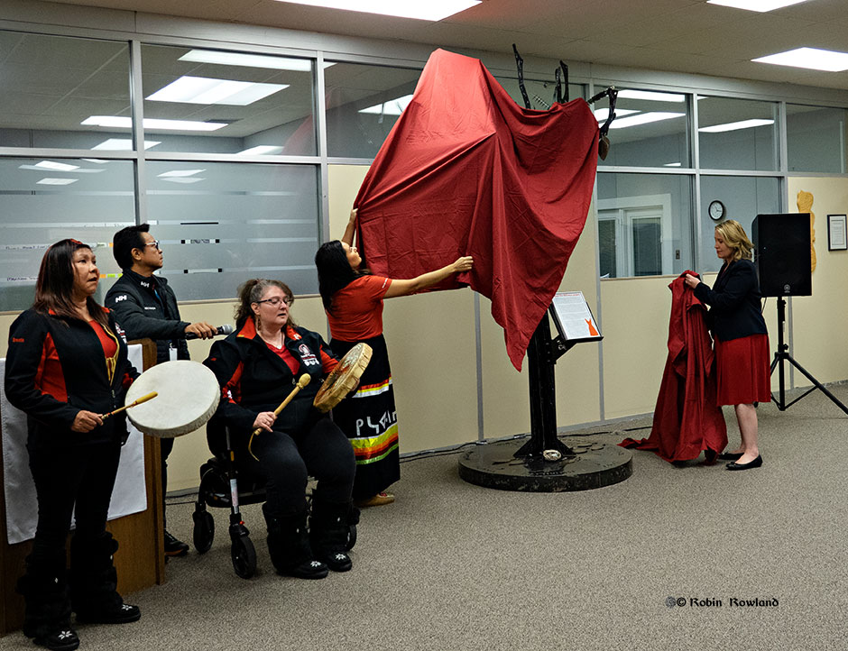
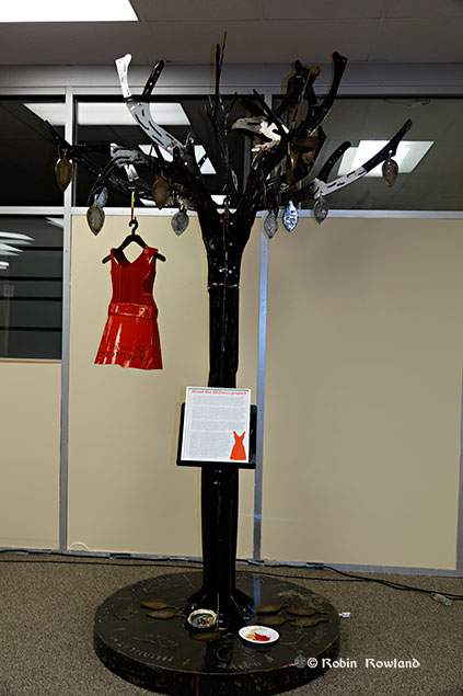
A welded and sculpted metal tree created by two Grade 12 students in memory of Canada’s murdered and missing indigenous women and girls was unveiled in the lobby of the Kitimat Valley Institute on Friday, October 4, 2109, where it will be on permanent display.
The tree was created by Trinity Harry, 17, Ojibwa Nation, from Little Black River, Manitoba and Joseph Ginter, 16, Ojie-Cree, from Garden Hill, Manitoba, students at the Russell Vocational High School in Winnipeg. The project was supported by the Arx & Sparx Welding Camp Program and the CWBwelding Foundation with sponsorship from LNG Canada. The company is supporting welding camps for young people to introduce them to a career in the skilled trades.
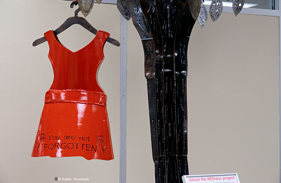
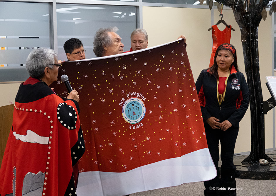
The memorial tree features a red dress, part of the Red Dress Project created by artist Jamie Black to bring attention to the issue of missing and murdered indigenous women across Canada by displaying red dress related art work across Canada. Most of the women, speakers and guests at the unveiling wore a red dress at the ceremony.
Harry and Ginter, along with their instructors, spent over 300 hours designing and fabricating the tree.
The memorial tree. (Robin Rowland)
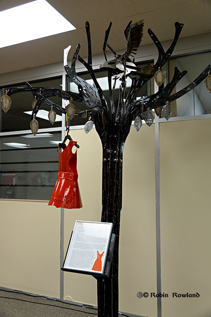
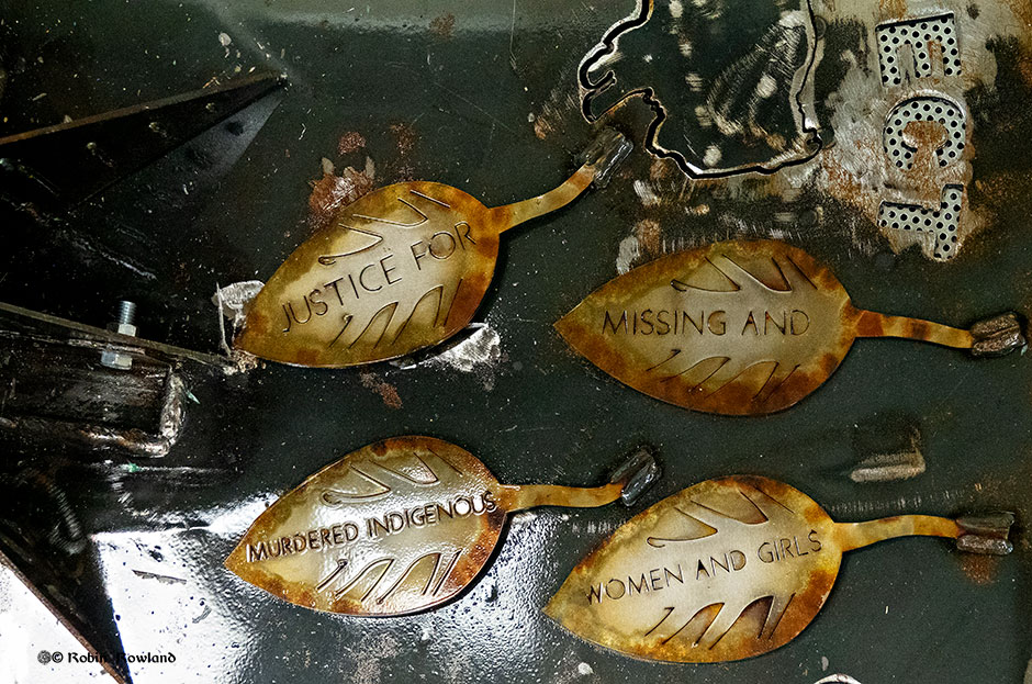
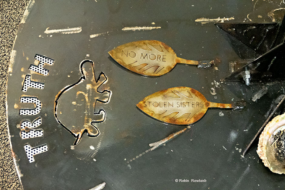
A plaque describes the tree as “dying.” Fallen leaves on the base represent the fallen indigenous women and girls. Future welding classes will add more leaves to honour more women.
The fallen leaves call for justice.( Robin Rowland)The leaves symbolize the indigenous women lost on Turtle Island (Robin Rowland)An eagle sits high in one of the branches of the tree (Robin Rowland)
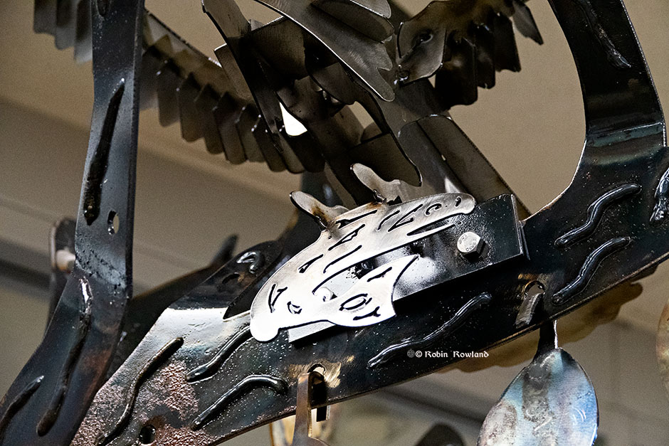
The eagle represents the love for the missing.
A salmon in the eagle’s talons. (Robin Rowland)
The salmon represents the Haisla Nation on whose traditional territory the sculpture is displayed.
The red of the dress has important spiritual value for many indigenous people in North America. (Robin Rowland)
According to the RCMP, at least 1200 indigenous women have been murdered or have gone missing during the past 30 years. The plaque says the red dress was chosen because “So red is really a calling back of the spirits of these women and allowing them a chance to be among us or have their voices heard through their family members and community.”
The memorial tree. (Robin Rowland)
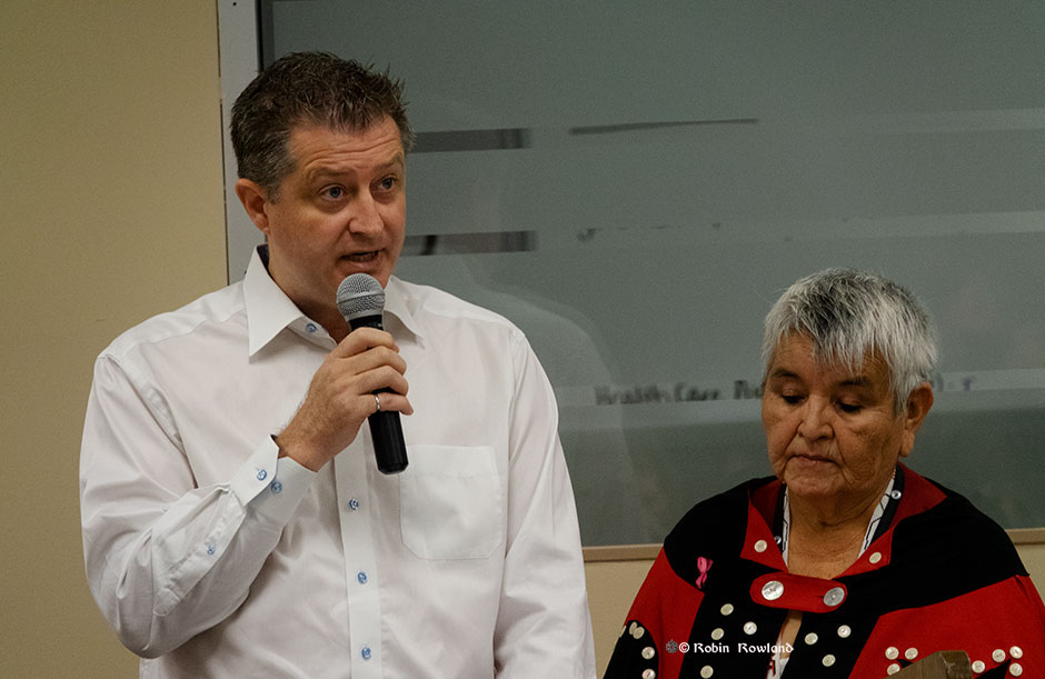
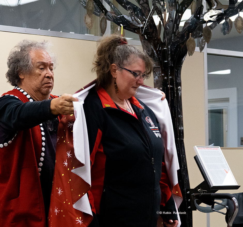
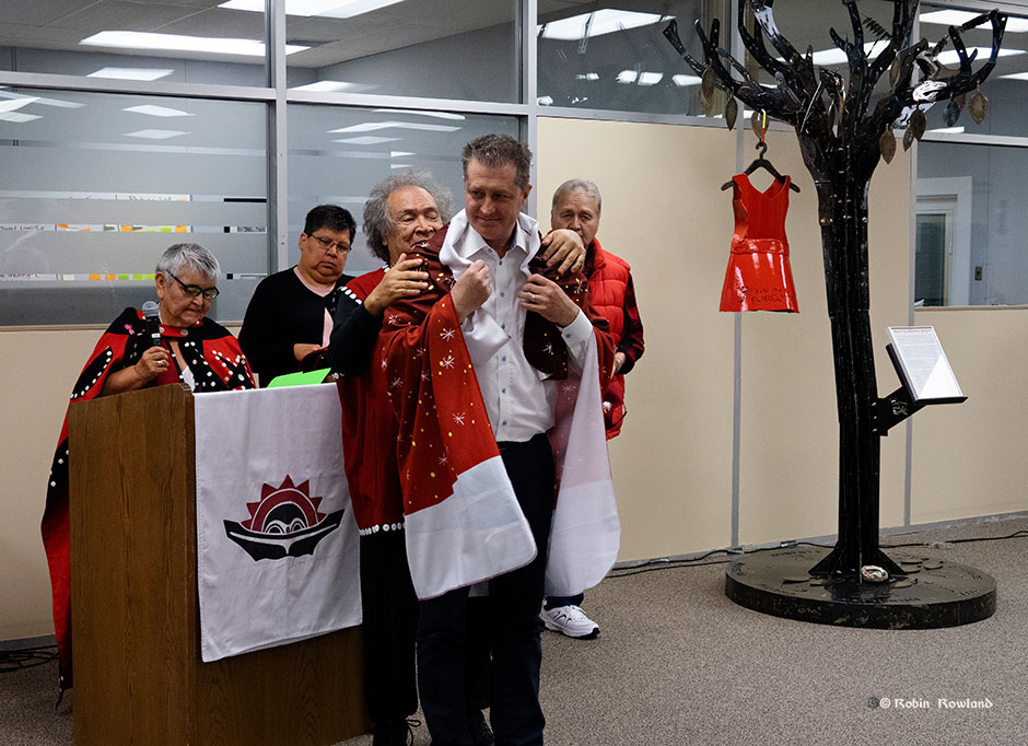
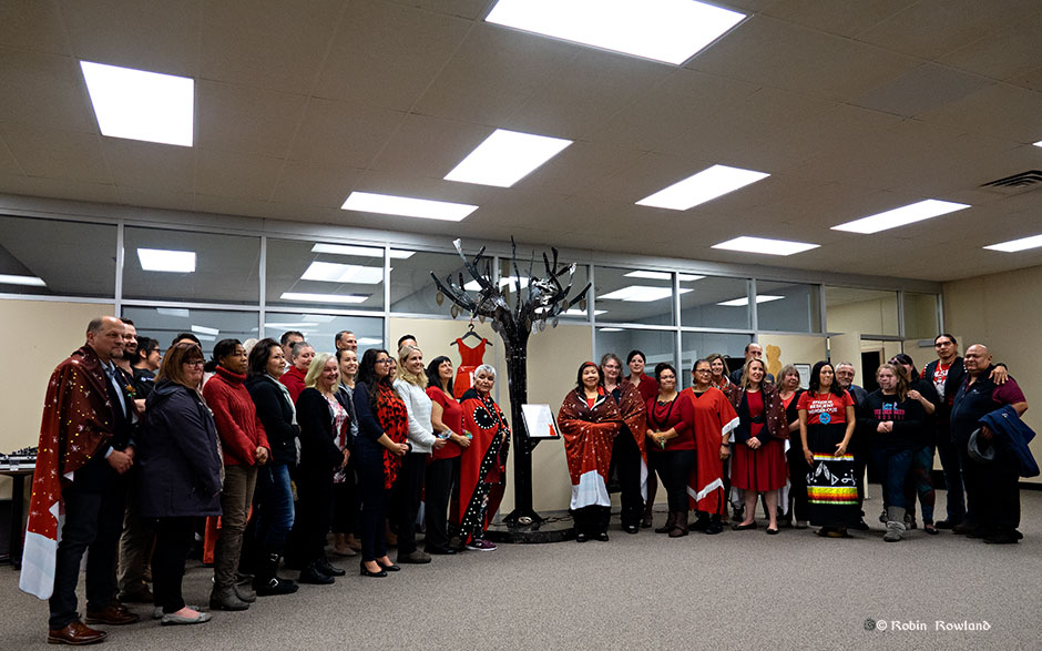
Haisla Nation chief counsellor Crystal Smith speaks to the gathering (Robin Rowland)LNG Canada CEO Peter Zebedee speaks to the gathering. Listening is Haisla Elder Marilyn Furlan. (Robin Rowland)Brenda Wilson of the Gitxsan Nation gave a moving address. Brenda’ sister Ramona was murdered near Smithers in 1995. (Robin Rowland)Haisla Elder Nelson Grant presents Brenda Wilson with a blanket in recognition of her work in leading an awareness march along the Highway of Tears. (Robin Rowland)Haisla Elder Nelson Grant presents Ann Bozoki of the Lheidi T’enneh Nation and the Khast’an drummers with a blanket in recognition of her work in raising awareness of missing and murdered indigenous women. (Robin Rowland)Haisla Elder Nelson Grant presents LNG Canada CEO Peter Zebedee with a blanket to thank him for the company support of the project the led to the memorial tree.(Robin Rowland)As can be seen in this group shot most of the women present wore red dresses for the unveiling ceremony. (Robin Rowland)
The District of Kitimat is very pleased with the decision that the BC government issued today removing some of the barriers associated with the establishment of an LNG industry in BC. This will promote access for natural gas from BC to be exported as LNG to international markets. This would be a significant boost for the North West, the province, and Canada as a whole.
This is a positive step forward for the LNG industry in BC, and the District of Kitimat is looking forward to working with the BC Government, LNG Canada, First Nations groups, other stakeholders as well as the Federal Government to move toward a positive final investment decision in 2018.
Michael Dewar
Director of Economic Development
News release from BC Premier John Horgan on his government’s LNG policy
For Immediate Release
March 22, 2018
Office of the Premier
NEWS RELEASE
New framework for natural gas development puts focus on economic and climate targets
VICTORIA – As part of a new approach to natural gas development, the British Columbia government is overhauling the policy framework for future projects, while ensuring those projects adhere to B.C.’s climate targets, Premier John Horgan announced today.
“Our new approach welcomes investment that puts our province’s people and future first, and rejects the old ways of resource development at any cost,” Premier Horgan said. “Our obligation is to the people who call British Columbia home, and our job is to get the best deal for them and the generations that follow.”
Under the new approach, all projects should:
* Guarantee a fair return for B.C.’s natural resources.
* Guarantee jobs and training opportunities for British Columbians.
* Respect and make partners of First Nations.
* Protect B.C.’s air, land and water, including living up to the Province’s climate commitments.
These four conditions form the basis for government’s discussions with LNG Canada, which is moving toward a final investment decision on a project that, if approved, would be the largest private-sector investment in B.C. history. This project would see the construction of a natural gas pipeline from northeast B.C. to Kitimat, where a new terminal will process and ship LNG to Asian markets. It is expected to create up to 10,000 construction and up to 950 full time jobs in northern B.C.
“No premier or government can dismiss this kind of critical economic opportunity for the people of British Columbia,” Premier Horgan said. “But neither will we turn our back on our commitment to climate targets, or our path to reconciliation with Indigenous peoples.”
At the centre of the discussions with LNG Canada is a revised fiscal framework that is designed to put natural gas development on a level playing field with other industrial sectors, accessing the same fiscal policies and working within the same overall B.C. framework to achieve greenhouse gas (GHG) reductions.
The new framework, to which LNG Canada will be subject, provides:
* Relief from provincial sales tax (PST), in line with the policy for manufacturing sectors, subject to repayment in the form of an equivalent operational payment.
* New GHG emission standards under the Clean Growth Incentive Program, announced in Budget 2018.
* General industrial electricity rates consistent with other industrial users in B.C.
* Elimination of the LNG income tax that had required LNG-specific tax rates.
“The LNG Canada proposal has the potential to earn tens of billions of dollars and create thousands of jobs for British Columbians over the life of the project,” Premier Horgan said. “It’s a private-sector investment that could benefit our province for decades to come, but not at any price – we need to make sure the values British Columbians believe in come first.”
The Premier said his government will also expect the LNG Canada project to fit within the goals of the Province’s climate-change plan and, specifically, its legislated GHG reduction targets.
“We committed, during the election campaign, to reduce our greenhouse gas emissions by 40% below 2007 levels by 2030, and by 80% by 2050. That remains our goal,” Premier Horgan said.
“We cannot achieve the necessary reductions in greenhouse gas emissions and do our part in protecting the global environment without a significant shift to a low carbon economy. The work for all of us – in government, business, labour and beyond – is only just beginning. And all resource development proposals must be considered within the context of our global commitment to protecting our air, land and water.”
With B.C.’s new fiscal framework provided to LNG Canada this week, it is anticipated the company will make a final investment decision sometime before the end of this year.
BACKGROUNDER 1
Climate action in British Columbia
On April 1, 2018, the carbon tax will increase by $5 a tonne annually, until 2022.
Increasing the carbon tax meets the requirements set out by the federal government’s pan-Canadian climate framework. Rebates will go to a majority of British Columbians.
However, increasing the carbon tax alone will not enable B.C. to meet its long-term greenhouse gas-reduction goals of 40% below 2007 levels by 2030, and 80% by 2050. Significant new climate-action initiatives will be required in order for B.C. to meet these 2050 legislated targets, while encouraging strong economic growth. To ensure an interim target, new legislated targets for 2030 will be introduced later this year. Specific targets for each of the industrial, transportation and building sectors will also be established.
Meeting climate targets will not be easy and will require a concerted effort across all sectors to make the transition to a low-carbon economy. The addition of emissions from LNG will increase this challenge but government is committed to taking the steps necessary to achieve B.C.’s climate goals.
Specific Measures:
* A portion of the carbon tax revenue, paid by large industry, will fund a rebate program to incent the use of the greenest technology available in the industrial sector, including the natural gas sector, to reduce emissions and encourage jobs and economic growth. Some of the revenue will also go into a technology fund, to help spur new, clean technologies in all sectors, to make sure they fit within B.C.’s climate plan.
* The Climate Solutions Clean Growth Advisory Council (CSCG), established in October 2017, is supporting government’s goal of reducing carbon pollution, preparing for the impacts of climate change and growing a sustainable economy. The CSCG is comprised of community leaders from across British Columbia, including representatives from First Nations, local government, industry, environmental organizations, academia and labour.
* The CSCG is providing advice on actions and policies to achieve significant greenhouse gas reductions, while taking advantage of opportunities for sustainable economic development and job creation.
* Immediate priorities for the CSCG include achieving emissions reductions in the transportation sector, developing pathways to clean economic growth, as well as policies to support the competitiveness of B.C.’s emissions-intensive and trade-exposed industries.
* Government is working to develop a framework for fugitive emissions that match the federal government’s target of a 45% reduction by 2025.
* Government is examining every opportunity to reduce emissions from slash burning by providing alternative economic usage for slash where available.
* Government has initiated a scientific review of hydraulic fracturing aimed at ensuring that industry in B.C. operates according to the highest-possible standards.
BACKGROUNDER 2
British Columbia establishes new framework for natural gas development
Natural gas has a key role to play to provide clean, reliable, affordable and less-carbon-intensive options to global energy markets.
British Columbia has a vast supply of low carbon-intensive natural gas resources in places like the Montney Basin, and has been developing them to support economic growth and job creation at home for decades. B.C. natural gas is an important transition fuel that can help B.C. move to a lower-carbon economy.
While B.C. has been exporting natural gas to U.S. markets for decades, it has an opportunity to export the same fuel to other jurisdictions. To that end, government will introduce a fiscal framework that will provide fair returns to both British Columbians and investors, as well as a climate strategy that will allow B.C. to meet its legislated climate targets.
To ensure British Columbia does it better than anybody else in the world, the provincial government has four key conditions to ensure British Columbians benefit from any proposed LNG development. They are:
* Guarantee a fair return for B.C.’s natural resources.
* Guarantee jobs and training opportunities for British Columbians.
* Respect and make partners of First Nations.
* Protect B.C.’s air, land and water, including living up to the Province’s climate commitments.
Emerging LNG Proposals
Despite the cancellation of Pacific Northwest LNG, Aurora and Woodside project proposals, several other LNG proponents have expressed renewed interest in developing projects in BC.
LNG Canada
LNG Canada’s proposed Kitimat project, should it proceed, represents a very significant economic opportunity for British Columbia – a project that involves one of the largest private sector developments in B.C. history.
Shell and its joint-venture partners have worked constructively to satisfy the provincial government’s conditions for LNG, and British Columbia expects LNG Canada will continue to do so moving forward.
LNG Canada is also working to achieve global leadership in low-emissions technology and operations.
Kitimat LNG
Chevron and its partners have expressed continued interest in developing its project in northern B.C. and is focusing on the use of new low-emissions liquefaction technology.
These come as the Province is completing a climate-action strategy in place that meets the Province’s greenhouse gas-reduction targets – to reduce B.C.’s greenhouse gas emissions by 40% below 2007 levels by 2030, and by 80% by 2050.
New Framework
The B.C. government has developed a new framework aimed at ensuring British Columbians receive a good return for their natural gas resource and proponents receive a reasonable return on investment.
As part of this work, British Columbia and LNG Canada jointly conducted a financial analysis of the LNG Canada project. This analysis corroborated evidence and information from internationally recognized LNG analysts that B.C. has a competitiveness issue and formed the basis of a mutual understanding upon which the Province is prepared to commit measures that will increase the competiveness of British Columbia’s LNG industry.
These measures provide a framework for other industries in British Columbia in similar circumstances – they are not exclusive to the LNG industry or LNG Canada.
As it pertains to LNG Canada, the measures detailed below will only be implemented if the proponents are able to conclusively decide on or before Nov. 30, 2018, to proceed with the construction of the LNG facility and associated investments. These measures below would apply to the entire LNG sector.
1. New Operating Performance Payments
Under current legislation, proponents constructing significant manufacturing facilities would receive a PST exemption on input costs, whereas those proposing to construct LNG facilities would not.
Under the new framework, The B.C. government will exempt LNG Canada from the provincial sales tax (PST), on the construction of their initial proposed facility. This will be conditional on LNG Canada entering into a separate agreement with the province whereby LNG Canada will pay annual operating performance payments over 20 years, a total amount equivalent to what LNG Canada would have otherwise paid in PST during the initial facility construction period.
This framework will be available to all proponents constructing significant manufacturing facilities in the province.Clean Growth Incentive Program
2. The provincial government recognizes that energy-intensive trade-exposed industries, including the natural gas sector, face unfair competition when competing globally with jurisdictions that do not impose carbon taxes. Proponents who make a final investment decision to proceed will be subject to the new Clean Growth Incentive Program, announced by the provincial government in Budget 2018. A benchmark for world-leading clean LNG production will be established as part of this program, replacing existing requirements under the current Greenhouse Gas Industrial Reporting and Control Act.
3. Industrial Electricity Rates
Proponents who make a positive final investment decision will receive the general industrial electricity rate charged by BC Hydro. This is the same rate paid by other industrial users in British Columbia.
4. Removal of LNG Income Tax
The existing LNG income tax is not the most efficient and effective tool for generating returns to British Columbia. It is cumbersome to administer and has led to uncertainties. Government intends to introduce legislation to repeal this tax and instead government will utilize a number other tax and royalty measures under its new fiscal framework, to ensure that British Columbia gets a fair return for its natural gas resource.
New Approach to LNG
As part of establishing a new fiscal framework, the provincial government will take steps to improve the transparency and consistency with which it assesses industrial development opportunities. To that end, government intends to introduce legislation to repeal the Project Development Agreement Act, passed by the previous government, to tie the hands of future governments with respect to the rules governing LNG projects. These measures effectively indemnified proponents against changes. Government will also review and potentially cancel or repeal other LNG measures established by the previous government.
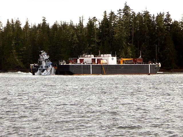
The second mate of the tug Nathan E. Stewart fell asleep on watch when the tug grounded off Bella Bella, on October 13, 2016, according to an investigation report released by the United States National Transportation Safety Board.
The NTSB also said “Contributing to the grounding was the ineffective implementation of the company’s safety management system procedures for watchstanding.”
The Nathan E. Stewart was pushing, not towing the barge, as the NTSB report notes:
The JAK system the tug used to push the barge (NTSB)
The tugboat Nathan E Stewart and the tank barge DBL 55 were connected through the JAK coupling system.1 Controlled from a panel on the tugboat’s bridge, this system uses a 16-inch-diameter, high-strength steel pin pneumatically actuated on each side of the vessel’s bow to lock the vessel into a fitted socket plate welded to each side of the barge’s inner notch. The plates have multiple sockets that run vertically, which allows the tugboat to position itself within the notch to accommodate changing barge drafts as well as to prevent, or minimize, the horizontal movement between the two units.
The NTSB says the grounding of the tug caused about $12 million US in estimated damage to the tug itself and the barge it was pushing.
The Nathan E. Stewart and barge on the rocks (RCMP/TSB)
The Nathan E Stewart spilled 29,000 gallons of fuel and lube oil, released into the ocean off Edge Reef, off Athlone Island in Seaforth Channel in the traditional territory of the Heiltsuk Nation.
Although no petroleum products were released from the empty fuel barge, a subsequent marine survey found that post accident survey of the DBL 55 found that the barge’s external double hull was significantly damaged from its bow completely aft to the skegs on the stern. There were multiple areas where the hull plating had been inset and penetrated. Some of the framing also had been damaged, but none of the inner steel plating comprising the bottom, sides,or top of the cargo tanks had been breached. The JAK socket plates on the inside of the barge’s notch showed slight damage,with the second recess(fromthe bottom up) on both socket plates indicating scarring and heavy contact. Repair costs for the barge were estimated at $5.6 million.
Prior to thegrounding, all the vessel’s vital systems were functional, and there were noindications of a mechanical failure thatmay haveled to the accident.
The NTSB says the tug was on autopilot when the second mate fall sleep on watch and it missed course correction near Ivory Island. The tug had a computerized electronic chart system (ECS) on board that should have sounded an alarm when the way point for the course correction was missed, but the mate told the NTSB, the tug was not using that navigation tool on the night of the accident. According to the second mate, it was
normal practice for the navigation team to not utilize that tool.
The NTSB report says had the ECS been utilized, the ECS would
have entered into an alarm mode after the second mate missed the port course change required near Ivory Island. Based on time, speed, and distance calculations, the alarm would have activated at approximately 0055 and thereby provided ample time for the second mate to take
corrective action to return the Nathan E Stewart to the intended track.
As related in Gordon Robinson’s Tales of the Kitamaat, the First Peoples living on the coast of what is now British Columbia ventured up what is now called Douglas Channel perhaps from either Bella Bella in Heiltsuk traditional territory or from Prince Rupert in Tsimshian traditional territory.
The young men on the expedition up the Kitimat Arm spotted what they thought was a huge monster kilometres ahead with a large mouth that was constantly opening and closing. The sight was so terrifying that the men fled back to their homes and dubbed the Kitimat Arm as a place of a monster.
Later a man named Hunclee-qualas accidentally killed his wife and had to flee from the vengeance of his father-in-law. Knowing he had to find a place where no one could find him, he ventured further up the Kitimat Arm. There he discovered that the “monster” was nothing more than seabirds, probably seagulls, perhaps feasting on a spring oolichan run.
He settled along the shore of what is now the Kitimat River and found a land of plenty, with fish, seals, game as well as berries and other natural products of the land. Eventually he invited others to join him, which began the Haisla Nation and he became their first chief.
Let’s examine the new evidence so far.
Settlement along the coastal “kelp highway” between 18,000 and 16,000 years ago, followed by a warm spell 14,500 years ago
It’s now fairly certain that the First Peoples first began to settle along the coast by following the “kelp highway” perhaps as early as 18,000 years ago and certainly by 14,000 years ago. Haida Gwaii was ice free, except for some mountain glaciation as early as 16,500 years ago. At about 14,500 years ago there was a warming spell which forced the glaciers to retreat, brought higher sea levels and the arctic like tundra ecosystem would have been replaced, at least for a time, by forests. There is the discovery of a Heiltsuk settlement dated to 14,000 years ago. At that time almost all of the coast would have been free of glacial ice but there were still glaciers in the fjords, including the Kitimat Arm which would mean there could be no permanent settlement in the “inland coast” and the interior.
(Science)
The cooling period from 14,000 to 11,700 years ago confines settlement to the coast
The cooling periods (with occasional warmer times) from about 14,000 years ago to about 11,700 years ago meant that settlement would largely have been confined to the coast for about two and half millennia. The culture of the coastal First Peoples would have been well established by the time the glaciers began the final retreat.
(Remember that it is just 2,000 years from our time in 2017 back to the height of the Roman Empire under Augustus Caesar).
It is likely that the cooling periods also meant that some descendants of initial settlers likely headed south for relatively warmer climates. Rising sea levels meant that the initial settlement villages would likely have been abandoned for higher ground.
A second period of rapid warming 11,700 years ago which opens up the interior fjords and valleys
At the end of what geologists call the Younger Dryas period, about 11,500 years ago, the climate warmed, the glaciers retreated further, in the case of Kitimat, first to what is now called Haisla Hill, then to Onion Flats and finally to Terrace.
Large glacial sediment river deltas filled with fresh melt water from retreating ice
The most important confirmation of the story of Hunclee-qualas’s exile is the account of the monster, the birds and the oolichan run.
The new scientific evidence, combined with earlier studies, points to the fact that the glacial melt water carried with it huge amounts of glacial sediment that created vast river deltas in coastal regions of the Northern Hemisphere.
That means around 10,000 years ago, when the Kitimat Valley was ice free and the new forest ecosystem was spreading up the valley, the Kitimat River estuary was likely to have been much larger than today. It could have been a vast delta, which would have quickly been repopulated with fish, including salmon and oolichan. That rich delta ecosystem could have supported a much larger population of seabirds than the smaller estuary in recent recorded history.
Snow geese by the thousands in the Sacramento-San Joaquin Bay Delta/ CrunchySkies/Wikimedia Commons/Creative Commons License
The story of the monster those first travelers saw far off is highly plausible. Even today in huge, rich deltas elsewhere in the world, seeing hundreds of thousands of birds in flight over a wetland is fairly common. (For a description of what a Kitimat River delta may have been like thousands of years ago, see KCET’s story on the Sacramento-San Joaquin Bay Delta and what that delta was like 6,000 years ago)
The First Peoples had had well established communities for up to four thousand years before the Kitimat Valley’s metres of thick ice had melted away. For the first period, while the ecosystem regenerated, for the people of the coast coming up Douglas Channel to the valley would not have been worth it, there would be little to find in terms of fish, game or forest resources.
A Snow Goose flock near the Skagit River Delta, WA./ Walter Siegmund/Wikimedia Commons
The change from tundra to a rich forest environment
Eventually as the forest regenerated, the streams filled with salmon and oolichan; the bird population including gulls, geese and eagles, found a new feeding ground; bears, deer and other animals arrived. The Kitimat region would have been an attractive place to explore and hunt. It may be the monster story did keep people away until Hunclee-qualas had to find a place to hide and discovered a new home just at a time that might be called an ecological optimum with new forests stretching back along the valley to what is now Terrace.
The river delta shrinks back to the current estuary
If a vast Kitimat River delta did stretch further down the Channel than it does in 2017, it likely shrank back in the subsequent millennia. Eventually the mass of glacial sediment that came downstream after the retreat of the ice would diminish, but not stop entirely. The estuary is still rebuilt from sediments washed downstream but that sediment doesn’t match other rich deltas elsewhere such as the Nile in Egypt. With that regeneration of the delta slower and smaller than in the first centuries of Haisla settlement, at the same time the land surface rebounded from the weight of the ice, perhaps creating the Kildala neighborhood. The ocean level rose, drowning and eroding part of the old delta, creating the estuary we know today.
As the authors of the paper on the First Peoples’ settlement note, most of the archaeological evidence of early coastal settlement is now likely many metres below the surface of the ocean but deep ocean exploration may uncover that evidence. As the scientific team on the second paper say, they are now working on detailed studies of the glacial retreat from the coastal mountain region which may, when the studies are complete, change the timeline
While waiting for further evidence from archaeology and geology it is safe to say that the stories of the monster and later Hunclee-qualas’s discovery of the Haisla homeland are even more compelling than when Gordon Robinson wrote Tales of the Kitamaat. We can now speculate that there was once, stretching from Haisla Hill far down the Channel, a vast, varied rich, river estuarine delta that supported hundreds of thousands of seabirds, which if they took the wing in unison, would have made those unwary travelers millennia ago, really think that there was a giant monster waiting to devour them at the head of the Kitimat Arm.
If some travellers, perhaps about 12,000 years ago, had headed up what is now called Douglas Channel, around the north end of Hawkesbury Island they likely would have seen a glacial retreat driven by a warming planet, something very familiar to the television viewers of 2017, video of 21st century coastal Greenland, where massive glaciers are calving ice bergs into the ocean.
The history of rapid glacial retreat over several thousand years from the interior and coastal British Columbia at the end of the last Ice Age is now becoming a crucial indicator of what may happen to both Greenland and the Antarctica. Under the current ice sheets both Greenland and parts of Antarctica are mountain ranges similar to those here in British Columbia. According to new research published to today in Science, that may indicate what could happen as those ice sheets melt and how that will affect volatile climate change.
The paper written by Brian Menounos of the University of Northern British Columbia and co-authors indicates that the glacial retreat in BC was faster than previously believed, beginning about 14,000 years ago. That left some parts of coastal and western BC ice free, rather than beginning 12,500 years ago as previously estimated. The last Ice Age probably reached its maximum coverage about 20,000 years ago.
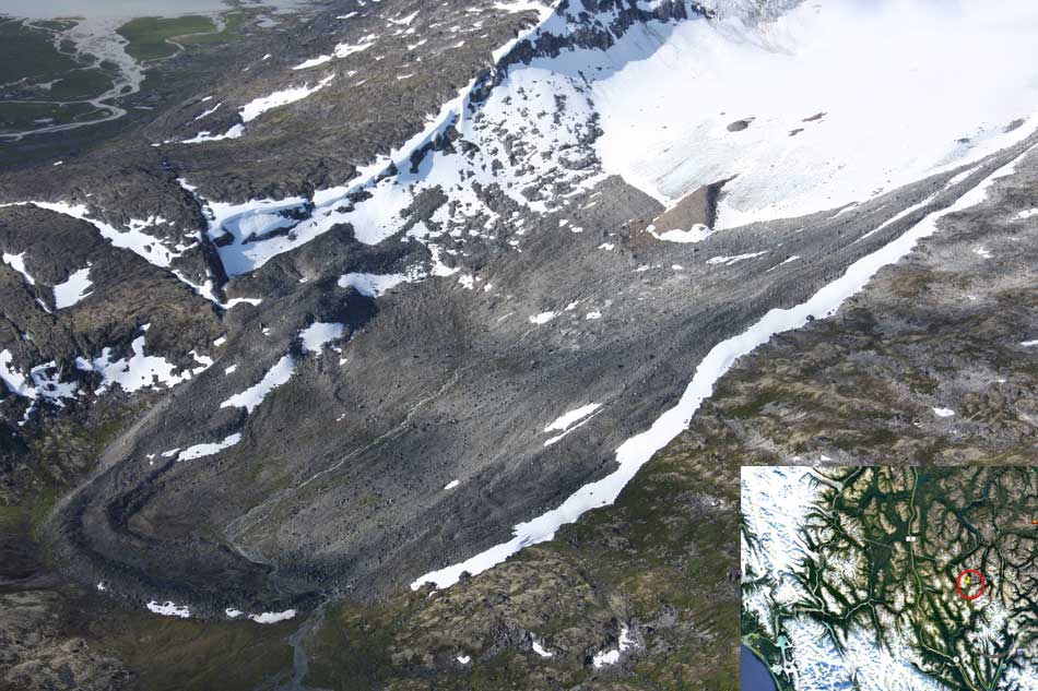
One of the cirque moraines at the end of a glacier studied by Brian Menounos and his team. It is in northern British Columbia just south of the Yukon border. ( Brian Menounos/Science plus Google Earth)
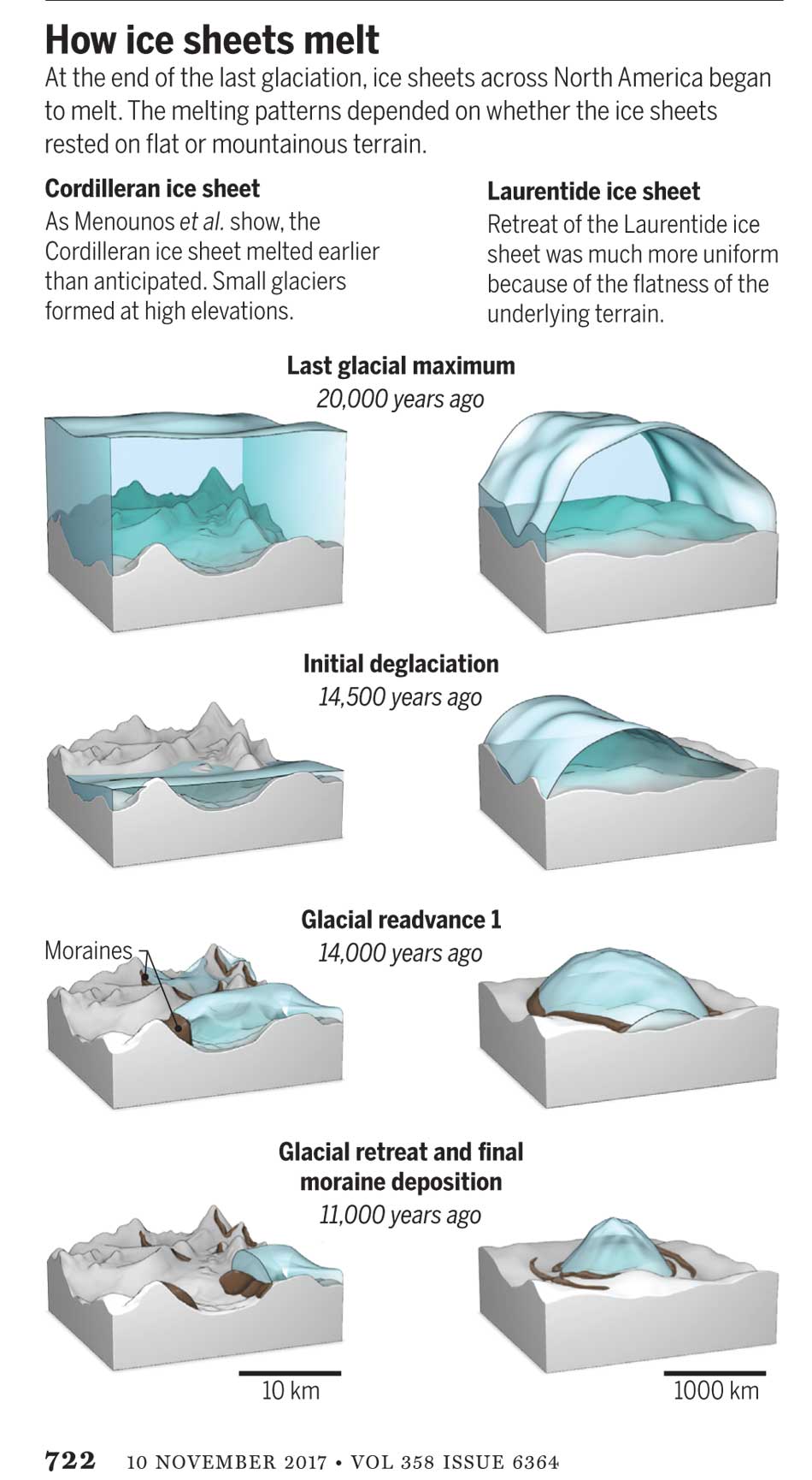
The decay of the ice sheet was complex, partly due to presence of mountainous terrain and also because Earth’s climate rapidly switched between cold and warm conditions during the end of the last Ice Age.
One of the factors that may have triggered a climate change back to colder conditions was a massive outflow of cold, fresh water from coastal British Columbia, which may have affected ocean currents.
What geologists call the Cordilleran ice sheet once covered all of present-day British Columbia, Alaska and the north Pacific United States. How the Cordilleran ice sheet responded to climate change was different from the Laurentide ice sheet which covered the flatter terrain (prairie and the Canadian Shield) of central North America. The Cordilleran ice sheet is about the same size as the current Greenland ice sheet.
“Our work builds upon a rich history of collaborative research that seeks to understand when and how quickly the Cordilleran ice sheet disappeared from Western Canada,” Menounos says. “Projected sea level rise in a warming climate represents one of the greatest threats to humans living in coastal regions. Our findings are consistent with previous modeling studies that show that abrupt warming can quickly melt ice sheets and cause rapid sea level rise.”
One of the co-authors of the paper is John Clague, now a professor emeritus of Earth Science at Simon Fraser University who studied the glaciation patterns in the Kitimat valley and Terrace in the 1970s when he worked for the Geological Survey of Canada.
Earlier researchers, including Clague, relied on radiocarbon dating to establish when the ice sheets disappeared from the landscape. The problem is that radiocarbon dating may not work in higher alpine regions where fossil organic matter is rare (above the tree line).
Menounos and the researchers used surface exposure dating – a technique that measures the concentration of rare beryllium isotopes that accumulate in quartz-bearing rocks exposed to cosmic rays – to determine when rocks first emerged from beneath the ice. If the rocks are under an ice sheet that means they are not exposed to cosmic rays, and thus measuring the beryllium isotopes can indicate when the retreating ice exposed the rocks to the cosmic rays.
The scientists studied small “cirque moraines” found only beyond the edge of modern glaciers high in the mountains, and valley moraines.
The alpine cirque moraines could not have formed until after the Cordilleran ice sheet had retreated. Menounos and his team show that several alpine areas emerged from beneath the ice sooner than previously believed. Then once the mountain peaks emerged from the thinning ice, new, smaller glaciers grew back over the high-elevation cirques at the same time that remnants of the ice sheet “reinvigorated” in the valleys during subsequent climate reversals
Most of the work of the team was done in the interior of British Columbia, the Yukon and Northwest Territories. Menounos says that new, similar work is being done on the mountains of the coastal region which will be published when the research is complete.
At its maximum, the Cordilleran ice sheet likely extended from what is now the mainland coast across Hecate Strait to the east coast of Haida Gwaii.
Starting about 14,500 years ago, the planet entered a phase of warming, with the average temperature rising about 4 degrees Celsius over about a thousand years. The Cordilleran ice began to thin rapidly leaving what the paper calls a “labyrinth of valley glaciers,” which then allowed the alpine glaciers to re-advance.
Diagram from Science shows how the glaciers retreated at the end of the last Ice Age, with the mountainous Cordilleran ice sheet behaving differently from the central North American Laurentide ice sheet (Science)
The scientists have suggested the rapid ice loss, beginning 14,500 years ago, came relatively quickly in geological time, perhaps just 500 years. That may have then contributed to subsequent Northern Hemisphere cooling through freshwater rushing into the ocean. That melt water disrupted the overturning ocean circulation of cold and warm water. That led to a new cooling period that lasted from about 14,000 to 13,000 years ago. (Similar to the completely fictional scenario in the movie The Day After Tomorrow, where the cooling happens in days not centuries).
That same outflow could have raised then existing sea levels by two and half to three metres, Menounos says. (The overall sea level on Earth rose about 14 metres by the end of the Ice Age)
Then the climate reversed again, first briefly warming and then in a period that saw another abrupt change back to cooler conditions which geologists call the Younger Dryas, The Younger Dryas occurred beginning about 12, 900 years ago to about 11,700 years ago, when warming began again. The Dryas is named after a wildflower that grows in arctic tundras.
The study indicates that the First Peoples could not have settled the interior of what is now British Columbia prior to the Younger Dryas, but it is likely as was explored in a paper last week in Science that the First Peoples were able to come down the “kelp highway” on the coast by at least 14,000 years ago.
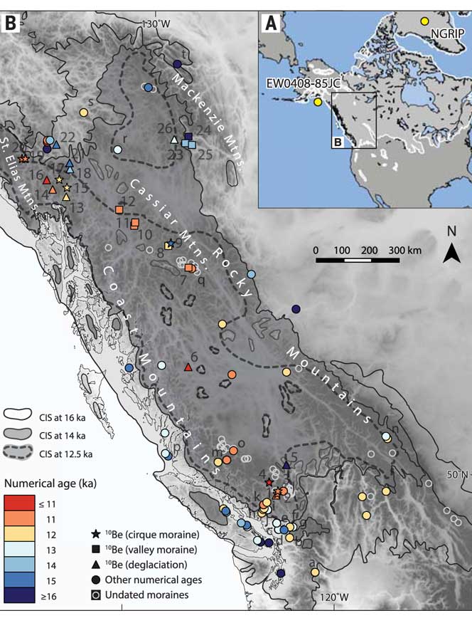
Map of British Columbia showing the extent of the glaciation during the last Ice Age and now the ice retreated. The coloured graphics are where the study was done mostly in the interior of BC and the age of the deposits. KA means kilo-years or thousand years ago. (Science)
So what happened in Douglas Channel?
So what does the new study of glacial retreat mean for the history of Douglas Channel?
John Clague studied the Douglas Channel, the Kitimat Valley and the Terrace area in the 1970s and was one of the co-authors of the current study that provides a new timeline for the retreat of the glaciers on the British Columbia coast.
He says that the timeline from his work in the 1970s with radio carbon dating of fossilized organic material is fairly consistent with the new work by Brian Menounos of the University of Northern British Columbia using the beryllium isotope technique.
The paper, Clague says, is more of a general commentary on the last stages of the decay of the Cordilleran ice sheet.
“At the time we’re taking about in the paper, there was ice in the corridor between Kitimat and Terrace.
“What we see in detail based on the work I did ages ago, is the retreat of the glacier from the Kitimat Arm back to the north towards Terrace [in the Young Dryas ]. It occasionally stabilized and the melting ice discharged a lot of sediment into that marine embayment.
Based on his original work and the new study Clague says at the time, the mountains are beginning to become ice free but there was still ice in the major valleys such as the Skeena Valley and the corridor south of Terrace towards Kitimat.
“They’re overlapping stories.” Clague says.
“The ice sheet hadn’t completely disappeared at the time Brian is focusing on,” Clague says. “His point is that a lot of the mass of the ice sheet appeared to be thinning and through marginal retreat from Haida Gwaii and some of the islands off the mainland back toward the mainland itself. So we’re trying to put a chronology on it, as to the various steps in the glacial decay.”
The work seems to indicate that the final ice sheet retreat happened in four stages around 12,000 to 11,000 years ago. “I was interested in the detailed reconstruction of the ice front tracked north from Kitimat you see a number of periods when it stabilized long enough to build up very large deltas and braided melt water plains,” Clague says.
The first moraine is Haisla Hill in Kitimat, where the glaciers discharged large amounts of sediment into what is now Douglas Channel. The second is the hill leading to what is called Onion Flats, the third is the flat area where the Terrace Kitimat Regional Airport now is and the final stage of glacial retreat created the “terraces’ around Terrace and Thornhill.
“It’s interesting that in this area there was so much sediment discharged into the sea remarkably for the time over which the ice was retreating through the area. It had to have been a major kind of discharge point of water from the ice sheet south from Terrace towards Kitimat otherwise you wouldn’t get that huge amount of sediment deposited probably over a period of a thousand years. Then it retreated again to just north of the airport and anchored there for a while and we found evidence for a final last gasp upstream around Thornhill and that kind of near Terrace.”
“At that time some of the high elevation glaciers were re-energized and readvanced, but it probably didn’t affect the overall health of the ice sheet itself It’s such a big mass of ice that it doesn’t respond quickly to such a brief cooling so what we’ve done in many places is these glaciers actually advanced up against ‘the dead ice’ an ice sheet that was lower in elevation.”
At the times the oceans rose at the end of the Ice Age, there were “sea corridors” between Kitimat and Terrace and also in the Skeena Valley. “So you can imagine there were arms of the sea extending to Terrace from two directions almost making that area which is now part of the mainland an island.” But the region likely never did become a true island, Clague says because as the ice sheets retreated,, they were also shedding large amounts of sediment that would become land area at the same time as the earth’s crust was rebounding once it was freed from the weight of the ice sheet.
Most historians and archaeologists believe that the First Peoples to arrive in North America came down the West Coast on what they now call the “kelp highway.”
Evidence from archaeological sites from the British Columbia coast to the southern tip of South America show that First Peoples had settled on both continents by at least 18,000 years ago, according to authors T.J. Braje at San Diego State University in San Diego, CA; T.D. Dillehay at Vanderbilt University in Nashville, TN; J.M. Erlandson at University of Oregon in Eugene, OR; R.G. Klein at Stanford University in Stanford, CA; T.C. Rick at National Museum of Natural History, Smithsonian Institution in Washington, DC.
The paper also says the DNA genomic data suggests a northeast Asian origin for Native American ancestors some time in the past 20,000 years.
(Science)
One of the key sites cited in the paper is Triquet Island in the traditional territory of the Heiltsuk Nation which has been dated to at least 14,000 years ago. Heiltsuk oral history has marked the island for generations, William Housty a member of the Heiltsuk told CBC News at the time the discovery was officially announced in April 2017, “Heiltsuk oral history talks of a strip of land in that area where the excavation took place. It was a place that never froze during the ice age and it was place where our ancestors flocked to for survival.”
The authors of the review say the new consensus on the “kelp highway” is a “dramatic intellectual turnabout” from the original idea that the first indigenous settlers followed an ice free corridor from a land bridge from Siberia down the centre of North America to form the “Clovis Culture”
The land bridge between northeast Asia and North America, commonly called Beringia, came about when sea levels fell during the last ice age. Although the original Beringia hypothesis has been disputed by some First Peoples, the paper says the Beringia hypothesis is still a factor—but much farther back in time, now about 24,000 years ago.
The paper says:
most archaeologists and other scholars now believe that the earliest Americans followed Pacific Rim shorelines from northeast Asia to Beringia and the Americas.
According to the kelp highway hypothesis, deglaciation of the outer coast of North America’s Pacific Northwest about 17,000 years ago created a possible coastal corridor rich in aquatic and terrestrial resources along the Pacific Coast, with productive kelp forest and estuary ecosystems at sea level and no major geographic barriers
The paper says that kelp resources extended as far south as Baja California, and then—after a gap in Central America, where productive mangrove and other aquatic habitats were available—picked up again in northern Peru, where the cold, nutrient-rich waters from the Humboldt Current supported kelp forests as far south as Tierra del Fuego.
The other sites cited in the paper are
Huca Prieta, Peru 15,000 to 14,500 years ago
Paisley Caves, Oregon 14,000 years ago
Monte Verde, Chile 14,500 years ago
Page-Ladson, Florida 14,500 years ago
Channel Islands California 13,000 years ago
Quebrada Santa Julia and Quebrada Huentelauquén , Chile 13,000 years ago
Quebrada Tacahuay Peru 13,000 years ago
Quebrada Jaquay, Peru 13,000 years ago
In an earlier article in Science in August, Knut Fladmark, a professor emeritus of archaeology at Simon Fraser University who was one of the first to propose a coastal migration into the Americas back in 1979, said: “The land-sea interface is one of the richest habitats anywhere in the world,” noting that early Americans knew how to take full advantage of its abundant resources.
Testing the kelp highway hypothesis is challenging, the scientists say, because much of the archaeological evidence would have been submerged by rising seas since the end of the last “glacial maximum,” about 26,500 years ago.
The earlier that the First Peoples arrived, that means the land they originally settled is now the further offshore from the current coast (land which is now likely also at greater depth under the current ocean). So the review says that finding the evidence means that, “enlarging already vast potential search areas on the submerged continental shelf.”
The authors say:
Although direct evidence of a maritime pre-Clovis dispersal has yet to emerge, recent discoveries confirm that late Pleistocene archaeological sites can be found underwater. Recent discoveries at the Page-Ladson site, in Florida produced 14,500-year-old butchered mastodon bones and chipped stone tools in the bottom of Florida’s Aucilla River.
The report says that “Several multidisciplinary studies are currently mapping and exploring the submerged landscapes of North America’s Pacific and Gulf of Mexico coasts, searching for submerged sites. .
In British Columbia, those studies (pdf) include the discovery by Daryl Fedje, an archaeologist at the University of Victoria and the Hakai Institute of 29 footprints on Quadra Island. A piece of wood embedded in a footprint’s fill provided the radiocarbon date of 13,200 years ago and the spear points lying and a cluster of bear bones at Gaadu Din cave on the Haida Gwaii dated to 12,700 years ago.
The review says that for much of the 20th century, most archaeologists believed humans first colonized the Americas about 13,500 years ago via the overland route that crossed Beringia and followed a long and narrow, mostly ice-free corridor to the vast plains of central North America. There, according to the earlier theories, Clovis people and their descendants hunted large game and spread rapidly through the New World.
This was initially confirmed by twentieth-century discoveries of distinctive Clovis artifacts throughout North America. Some finds associated with mammoth or mastodon kill sites, supported this “Clovis-first” model.
The early studies decided then that “North America’s coastlines and their rich marine, estuarine, riverine, and terrestrial ecosystems were peripheral to the story of how and when the Americas were first settled by humans.”
Now the recent work along the Pacific coastlines of North and South America has revealed that these environments were settled early and continuously, providing a rich diversity of subsistence options and technological resources for New World hunter-gatherers.
A detail of the map from Science shows how off from the current coast the ancient shorelines reached (Science)
At the moment, there is little evidence on the coast so far of the kind of stone tools and fishtail points that had previously provided a road map that archaeologists used to trace the spread of “Clovis” Paleoindians throughout the Americas. Such a roadmap is lacking for “pre-Clovis” sites on the coast.
One proposal is that distinctive stemmed (“tanged”) chipped-stone projectile points, crescents (lunate-shaped), and leaf-shaped bifaces found in Japan, northeast Asia, western North America, and South America could be potential markers of an earlier coastal migration and ties to Ice Age peoples in East Asia.
The problem of finding final proof of the kelp highway is that the First Peoples followed a coastal route from Asia to the Americas, so that finding evidence for their earliest settlements will require careful consideration of the effects of sea level rise and coastal landscape evolution on local and regional archaeological records.
The scientists note that around the globe, evidence for coastal occupations between about 50,000 and 15,000 years ago are rare because of postglacial sea level rise, marine erosion, and shorelines that have migrated tens or even hundreds of kilometers from their locations at the ice age glacial maximum.
They say overcoming these obstacles requires interdisciplinary research focused on coastal areas with relatively steep offshore bathymetry, formerly glaciated areas where ancient shorelines have not shifted so dramatically, or the submerged landscapes that are one of the last frontiers for archaeology in the Americas
The staff of the National Inquiry into Missing and Murdered Indigenous Women and Girls will be in Smithers beginning on Monday, July 17 to consult with First Nations and other members of the Highway 16 communities.
The full Truth Gathering Process community hearings will begin in Smithers on September 25 for one week.
Skeena Bulkley Valley MP Nathan Cullen commented, “The announcement that the National Inquiry into Missing and Murdered Indigenous Women and Girls (MMIWG) will soon stop in Smithers is good news for families along the Highway of Tears who have lost loved ones to violence.
“It is absolutely essential for inquiry commissioners to travel to Northwest BC to hear directly from families along the Highway of Tears, Cullen said. “Reading statements and stories online or by letter does not have the same impact nor impart the very real dangers that First Nations women and girls face when travelling between remote, rural Highway 16 communities.”
In a news release July 6, (pdf) Chief Commissioner Marion Buller announced that “the National Inquiry is moving forward on the advice and guidance heard from families, survivors and grassroots organizations about how best to hear their stories of violence against Indigenous women and girls, including LGBTQ2S people. This next step is rooted in the knowledge gained from meetings that took place across Canada, with the latest being from the hearings in Whitehorse in May/June 2017.”
At Smithers and other locations the preliminary meetings will allow staff to participate in community visits to lay the groundwork for the hearings as part of the National Inquiry’s Truth Gathering Process.
Community visits allow:
the health team and legal counsel to meet with family members and survivors to prepare them for the community
hearings;
the community relations team to meet with local organizations, Indigenous groups and women’s groups to learn more
about local issues regarding violence against Indigenous women and girls, including LGBTQ2S people
the logistics team to conduct site visits for the upcoming hearings;
National Inquiry staff to seek the advice and guidance from Elders and knowledge keepers so that when we return to the
community hearings we may respect and include local protocols and ceremonies.
For individuals and families who wish to participate in the hearings, the inquiry has set up a six step process that is outlined on their website. How to participate in the MMIWG hearings (pdf)
Cullen says he hopes last Thursday’s announcement of the second round of community visits and hearings by commissioners opens the door to a more productive and collaborative process.
“There have been many challenges to getting the work of the inquiry off the ground, directly including families in the work, and developing a sufficiently broad mandate to allow real understanding of the deeper issues of violence against Indigenous women and girls,” he said.
“The inquiry’s recognition of the need to hold hearings in Smithers is very positive.
The immune system genes that protected north coast First Nations from possibly dangerous local pathogens thousands of years ago likely increased their vulnerability to European diseases in the nineteenth century, resulting in the disastrous population crash, a new genetic study has discovered.
The study which included members of the Lax Kw’alaams and Metlakatla First Nations at Prince Rupert “opens a new window on the catastrophic consequences of European colonization for indigenous peoples in that part of the world,” the study authors said in a news release.
The study, published today in Nature Communications, looked at the genomes of 25 individuals who lived 1,000 to 6,000 years ago in what the study calls PRH—the Prince Rupert Harbour region– and 25 of their descendants who still live in the region today.
“This is the first genome-wide study – where we have population-level data, not just a few individuals – that spans 6,000 years,” said University of Illinois anthropology professor Ripan Malhi, who co-led the new research with former graduate student John Lindo (now a postdoctoral researcher at the University of Chicago) and Pennsylvania State University biology professor Michael DeGiorgio. Both studies were carried out with the consent and cooperation of the Coastal Tsimshian people.
The new study analyzes the “exome,” the entire collection of genes that contribute to a person’s traits.
The ruins of a Haida longhouse at Tanu. Smallpox and other diseases brought a catastrophic population crash among coastal First Nations in the nineteenth century. (Robin Rowland/Northwest Coast Energy News)
“Oral traditions and archaeological evidence to date have shown that there has been continuous aboriginal occupation of this region for more than 9,000 years. This study adds another layer of scientific data linking the actual ancestral human remains to their modern descendants through their DNA over a span of 6,000 years,” said Barbara Petzelt, a co-author of the study and a liaison to the Metlakatla community. “It’s exciting to see how this tool of DNA science adds to the larger picture of Coast Tsimshian pre- and post-contact history – without the taint of historic European observer bias.”
In the new study, the team found that variants of an immune-related gene that were beneficial to many of those living in the region before European contact proved disadvantageous once the Europeans arrived.
The genes, the human leukocyte antigen gene family, known as HLA, helps the body recognize and respond to pathogens, or disease causing bacteria and viruses.
The authors say the “the immunological history of the indigenous people of the Americas is undoubtedly complex.”
As people came to the American continents about 15,000 to 20,000 years ago “indigenous people adapted to local pathogens.”
Statistical analyses revealed that the ancient genes were under “positive selection” before European contact. Natural selection meant that those ancient people with genetic resistance to those local diseases had an advantage that resulted in the genes becoming part of the population.
But the study indicates “those adaptations would have proven useful in ancient times but not necessarily after European colonialists altered the environment with their pathogens, some of which may have been novel. Existing genetic variation as a result of adaptation before European contact could thus have contributed to the indigenous population decline after European contact.”
The “positive selection” genes found in the remains of ancient members of the Coast Tsimshian people, has been replaced by another gene among the modern descendants that “has been associated with a variety of colonization-era infectious diseases, including measles and tuberculosis, and with the adaptive immune response to the vaccinia virus, which is an attenuated form of smallpox,” the authors wrote.
One of the genes is “64 percent less common today among the Coast Tsimshian people than it was before original European contact, which is a dramatic decline,” Lindo said.
The modern Coast Tsimshian show a “reduction in ‘effective population size’ of 57 per cent,” the researchers reported.
“’Effective population size’ is a population genetic concept that is different from what we normally think of with census population size,” Malhi said in an e-mail to Northwest Coast Energy News. “It basically means that there was a large drop in genetic diversity after European contact that could have been due to disease, warfare or other things that would result in this large population decline.”
The dramatic die-off occurred roughly 175 years ago, about the time that European diseases were sweeping through the First Nations of British Columbia.
While some members of the Coast Tsimshian community have intermarried with people of European descent over the past 175 years, the genetic changes cannot be solely attributed to what geneticists call “admixture.” The timing coincides with the documented smallpox epidemics of the 19th Century and historical reports of large-scale population declines. A majority of the “European admixture in the population likely occurred after the epidemics,” the study says.
To guard against what the study called “false positives” the genomes were also compared to individuals in the 1,000 Genome Project including 25 Han Chinese from Beijing as well as other indigenous peoples in the Americas including the Maya, the Suruí do Pará people of Brazil and a sample of Anzick DNA from the 12,000 year old remains of a child found buried in Montana.
“First Nations history mainly consists of oral stories passed from generation to generation. Our oral history tells of the deaths of a large percentage of our population by diseases from the European settlers.
“Smallpox, for our area, was particularly catastrophic,” said Jocelynn Mitchell, a Metlakatla co-author on the study. “We are pleased to have scientific evidence that corroborates our oral history. As technology continues to advance, we expect that science will continue to agree with the stories of our ancestors.”
The same vulnerability for smallpox, measles and tuberculous likely also contributed to the vulnerability to influenza, Malhi told Northwest Coast Energy News “It is important to note that any of these infectious diseases (measles, tuberculosis, smallpox, flu) could have resulted in the patterns that we are seeing. We just provided a few possibilities but not all possibilities.”
The study says the project was made possible through the active collaboration of the Metlakatla and Lax Kw’alaams First Nations.
The first collaborative DNA study began in 2007 and 2008. The scientists visited the communities each year “to report the most recent DNA results and obtain feedback on the results.”
“The two communities agreed to allow DNA analysis of ancestral individuals recovered from archaeological sites in the region and currently housed at the Canadian Museum of History. During and after community visits and extensive consultation, a research protocol and informed consent documents—agreed on by the indigenous communities and researchers—was approved by the University of Illinois Institutional Review Board. All individuals signed an informed consent document.”
These results were reported to the community and the scientists continue to visit the First Nations to report on this and related studies.
The study is titled “A time transect of exomes from a Native American population before and after European contact” and appeared in the Nov. 15, 2016, edition of Nature Communications.
UPDATED with comments from District of Kitimat, Terrace and the Gitga’at Nation
A preliminary seismic hazard assessment by Natural Resources Canada has identified possible earthquake scenarios for the Douglas Channel near Hartley Bay, Terrace and Bella Bella.
The same studies indicate that while Kitimat may not be directly in a seismic zone prolonged earthquakes cause some damage in Kitimat depending on the earthquake and the condition of the soil in certain parts of the District. One model scenario says that in the event of a magnitude 8.0 earthquake off the west coast of Haida Gwaii, given certain soil conditions, there might actually be more damage in Kitimat than on the islands.
Susceptibility to landslides
That assessment, part of the overall the study by the Geological Survey of Canada indicates that the north coast of British Columbia from Prince Rupert to Bella Bella is likely face to “seismically induced ground failure”– mostly landslides.
Overall, the report says that on a scale of 1 to 6 (6 representing the highest
susceptibility), the majority of the west coast of BC “exhibits landslide susceptibility values of 5 to 6, which is significantly higher than the rest of Canada.”
Geological Survey of Canada map showing parts of Canada that are prone to landslides. The BC North Coast study area is outlined by the rectangle. (Geological Survey of Canada)
In British Columbia the landslides are most likely to be triggered by delayed melting of the annual snow pack, heavy rains, bank erosion and site loading and caused long-lasting damning of the river causing “damage to pipelines, rail, and forestry, as well as fish habitats.”
So far no recent landslides along the northern British Columbia coast are known to be caused by earthquakes, the reports say “the existence of numerous landslides strengthens the likelihood of seismically induced ground failures… due to the high levels of seismicity….it is expected that the increased likelihood of strong ground shaking (with long durations) will increase the landslide susceptibility.”
New studies
It was only after the 2012 Haida Gwaii earthquake and with what the Geological Survey of Canada calls “a growing number of on-going and planned infrastructure projects, BC’s north coast is emerging as a region of high strategic importance to Canada’s economy,” that studies began in area where “there has been minimal research to understand earthquake hazards.”
Now that studies have begun the Geological Survey has given the region its own new acronym BCNC (BC North Coast). Haida Gwaii is not part of BCNC, although earthquakes on those islands would likely impact the coast.
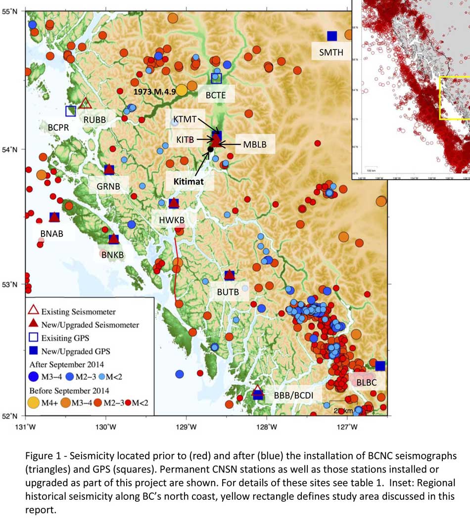
A Geological Survey of Canada map showing the BC North Coast region with earthquakes identified prior to and during recent studies. (Geological Survey of Canada)
The Geological Survey says that historically “the BCNC has been seismically quiescent.” As a result “seismic monitoring and research related to the BCNC has been minimal.” That meant while larger earthquakes were “felt and recorded,” the configuration of the Canadian National Seismograph Network did not allow earthquakes less than approximately magnitude 2.1 to be monitored in northern BC.
Now the Geological Survey is looking at “long-term, continuous monitoring of micro seismicity, combined with geodetic and paleo seismic techniques” that could be used to study at the possibility of large earthquakes, including a possible fault on the lower Douglas Channel.
Since the studies began in August 2014, the Geological Survey identified 145 earthquakes within the study area, many too small to be felt since they are less than magnitude 2.0. Those earthquakes, however, were picked up by the new and improved instrumentation used by the earthquake monitors.
The two reports one on “seismic hazards” and the second on “geohazards” says five “temporary seismonitors” (download reports from links below) were installed within the BCNC while some older stations were upgraded, saying, “It is expected that these new stations will be aid in locating small earthquakes” that were not previously detected by the existing network. The Geological Survey also installed ground movement monitoring GPS units along the coast.
The use of the term “temporary” raises the question about how much ongoing monitoring is planned.
The study also notes that the current data is not included in the seismic standards in the current National Building Code of Canada, which in turn is based on the Natural Resources Canada Seismic Hazard Map. That may mean that municipalities in the BC North Coast region, in the future, as the seismic studies continue, may have to consider updating building codes, especially in areas of “softer soils” as opposed to harder rock.
“Fault-like structure” on Douglas Channel
Detail of a map from the Geological Survey of Canada where the red line shows the 60 kilometre possible (still unconfirmed) fault line running from Gribbell Island to Princess Royal Island (Geological Survey of Canada)
Over the years some small earthquakes have also been recorded on what the Geological Survey calls the “recently mapped fault-like structure” on Douglas Channel which was discovered in 2012. The survey is still calling it “fault-like” because it has not yet been confirmed as an active fault. A new map in the study shows that the “fault” runs from the southern tip of Gribbell Island, down the centre of Whale Channel east of Gil Island and then along the western coast of Princess Royal Island.
The study identified “a small, unfelt swarm of earthquakes between magnitude 1.7 and 2.0 between September 13 and 14, 2010 near Gil Island.”
There is also the previously identified ancient Grenville Channel Fault (ancient and believed inactive because it dates from the Cretaceous, the age of the dinosaurs) that runs from along Grenville Channel from Porcher Island in the north to Klemtu in the south which has experienced small earthquakes.
The report says geological studies of the Douglas Channel “fault-like structure” are a priority because, “Should this structure be determined to be an active fault, it would pose significant risk of earthquake-triggered landslides (and subsequent tsunami) from the susceptible Douglas Channel hill slopes.”
Clay and sand in Kitimat
The report also calls for more studies the local geology and soil conditions in the Kitimat Valley. A study back in 1984 by John Clague of Simon Fraser University showed that as the glaciers retreated during the last Ice Age there were “periods of stagnation” resulting in sediments that are thicker than other regions of British Columbia, Clague reported that in parts of Kitimat, the glacial moraine is hundreds of metres thick.
After the glaciers were gone, the sea levels rose and glaciomarine sediments (clay, silt up to 60 metres thick) were deposited until the sea level fell to present-day levels. The report says that as these marine deposits were exposed to fresh water, salts were leached out resulting in saturated, porous sediments, including clay, which are prone to failure. Boreholes in the Kitimat area show that the clay and sediments above the bedrock can range from 17 metres to 106 metres.
The report notes the presence of clay soils “can amplify ground shaking and secondary effects” as happened in November 1988 when there was an earthquake in the Saguenay region of Quebec.
Originally reported as a 6.2 magnitude but later downgraded to 5.9, on Nov. 25, 1988, the major earthquake was centered near the Quebec cities of Chicoutimi and Jonquière, with aftershocks felt as far away as Toronto, Halifax and Boston. The quake lasted for two minutes, catching thousands of people off guard and leaving buildings damaged and power out for hundreds of thousands of Quebecers.
The report says the most significant event within the BC North Coast study region (which as mentioned doesn’t include Haida Gwaii) was a magnitude 4.9 earthquake approximately 20 kilometers southwest of Terrace on November 5, 1973, which was felt as far as 120 kilometers away, with some minor damage (broken windows and cracked plaster) reported near the epicentre. The main shock at Terrace was preceded by a magnitude 2.5 foreshock four hours before, and followed by a felt magnitude 3.7 aftershock the next day.
Bella Bella at risk
Another area most at risk, according to the report, is southern part of the BC North Coast zone, near Bella Bella, which is close to the northern section Cascadia Subduction Zone a “1,000 kilometre long dipping fault that stretches from Northern Vancouver Island to Cape Mendocino California” which one day will cause a major earthquake along the fault.
Cascadia subduction zone (USGS)
The report says that a magnitude 9.0 or higher earthquake in the northern Cascadia Subduction zone close to Bella Bella would be similar to the March 2011 earthquake in Japan and the 1964 Good Friday earthquake in Alaska.
For the northern part of the BC North Coast region, hazards could come from either a major earthquake off Haida Gwaii or a similar earthquake in south-eastern Alaska.
The greatest hazard would come from “long period” earthquakes greater than magnitude 6.75 with an epicentre between 300 and 350 kilometers away where the shaking lasts longer than one second.
The Geological Survey modeled three possible scenarios for major earthquakes in the BC North Coast Region.
Model #1. A magnitude 8.0 Earthquake at Haida Gwaii
The Geological Survey Canada model for an 8.0 magnitude earthquake west of Haida Gwaii. The possible damage is colour coded in the table below the map according to the Modified Mercalli Intensity Scale. The red polygon represents the area of possible rupture in the model with the star representing the epicentre. (Geological Survey of Canada)
The model looked at a “plausible maximum predicted” magnitude 8.0 thrust fault earthquake off the west coast of Haida Gwaii which would be twice as strong in the fault area as the 7.8 quake on October 28, 2012 (Remember Magnitudes are based on a logarithmic scale. That means for each whole number higher, the amplitude of the ground motion recorded by a seismograph goes up ten times so magnitude 8 earthquake would result in ten times the ground shaking as a magnitude 7 earthquake)
For a short period earthquake, the report estimates that there would be minimal damage on Haida Gwaii similar to the damage from the 2012 earthquake with little or no damage on the BC North Coast.
A long duration, long period earthquake that lasted longer than one second and up to three seconds or longer “may effect taller structures and trigger ground failure (that is liquefaction and lateral shaking).” Kitimat would feel that earthquake with the worst shaking in parts of the District with what the report calls “sensitive soils.” Coastal islands would feel double the amount of shaking as would occur in Kitimat.
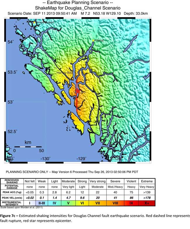
Model #2. A magnitude 7.2 Earthquake in Douglas Channel
The Geological Survey Canada model for a 7/2 magnitude earthquake in the lower Douglas Channel. The possible damage is colour coded in the table below the map according to the Modified Mercalli Intensity Scale. The red star represents the possible epicentre. (Geological Survey of Canada)
The second model looked at an earthquake in Douglas Channel based on the “fault like structure” if a slip strike rupture occurred along the entire 60 kilometers of the so far unconfirmed fault, resulting in a 7.2 magnitude earthquake. There would be very strong shaking within 20 kilometers radius of the epicentre, with moderate to heavy damage” in the relatively uninhabited islands, major shaking in Hartley Bay, resulting in very strong to strong damage at Hartley Bay and strong to moderate damage in Kitimat.
That earthquake, however, would be felt across the entire province of British Columbia. The report notes:
The expected effects and impacts of such an earthquake would mimic those of the 1946 magnitude 7.3 Vancouver Island earthquake, which occurred slightly west of Courtney and Campbell River. Shaking due to the 1946 earthquake was felt as far as Prince Rupert, BC to the north and Portland, Oregon to the south. In addition to knocking down 75 per cent of the chimneys in the local area, much of the earthquake-related damage was due to landslides, slumping and liquefaction
Model #3 A magnitude 6.3 Earthquake near Terrace
The Geological Survey Canada model for an 6.3 magnitude earthquake southwest of Terrace. The possible damage is colour coded in the table below the map according to the Modified Mercalli Intensity Scale. The red polygon represents the area of possible rupture in the model with the star representing the epicentre. (Geological Survey of Canada)
On May 11, 1973, a magnitude 4.7 shallow earthquake took place about 20 kilometers south west of Terrace, on the south side of the Skeena roughly across from the Shames mountain area. The earthquake was felt up to 120 kilometers away. The report says “The event has not been associated with any geologic features in the area and little is known about its rupture process.” The model estimated the results of a larger earthquake 6.3 magnitude in the same area. The model showed there would be strong to very strong shaking in Terrace, light to moderate shaking in Kitimat and light damage elsewhere in the BC North Coast. Most of the damage would be concentrated in a 20 kilometer zone around the epicentre.
The cause of the two failures is still unknown but the report says “their proximity to a nearby unmapped fault-like structure suggests that the slides could have been triggered by strong ground shaking from rupture along this structure.”
Another factor was the two well-known landslides occurred in the 1970’s in the Kitimat Arm which generated tsunamis but fortunately they occurred at low tide which decreased the impact. On October 17, 1974 a submarine slide generated a 2.8 metre tsunami. The following year on April 27, 1975, a slope failure on the northeast side of Kitimat Arm (which overlapped the 1974 failure area) displaced an estimated upper limit of 26,000,000 cubic metres of material.
“Watermark observations in Kitamaat Village estimated that the tsunami generated by this slide was up to 8.2 metres high.” The report says that while the trigger of the first event is unknown; the latter event coincided with nearby construction at that time. Modelling of the 1975 slide estimates that given the right conditions the generated tsunami waves could have been as high as 11 metres.
The report also notes that numerous landslides have also been mapped by the BC Department of Forestry in an attempt to improve safety measures for forestry workers.
The report says “The culmination of these studies brings awareness to the significant natural hazards present in the fragile coastal environment of the Coast Ranges.”
Another factor is the geology of the BC coast. The granitic mountains have rugged, steep slopes dissected by an intricate fjord system and dotted with islands of lower elevation. At lower elevations the land is covered by wet, coastal hemlock forests, which could be vulnerable to ground failures whereas higher elevations are characterized by barren rock or mountain hemlock subalpine.
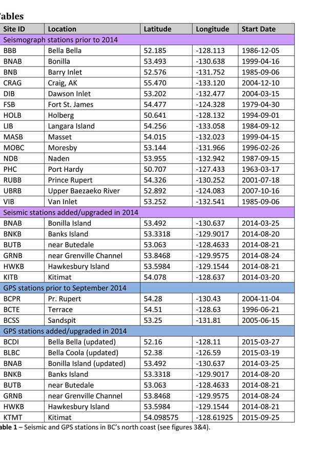
Table of Seismic monitoring and GPS stations in northern BC from the Geological Survey of Canada (Geological Survey of Canada)
The District of Kitimat said it has “not directly studied these issues but we are aware of potential hazards.” The development department has been advised of potential issues and site concerns.
A spokesperson for Terrace mayor Carol Leclerc told Northwest Coast Energy News in an e-mail. “I have reviewed it and distributed it to the relevant department heads. We are aware that historically Terrace has been at risk for experiencing seismic activity due to its location.”
The District of Kitimat did cooperate with National Resources in finding a location for their recently installed seismic equipment.
At Harley Bay, Gitga’at First Nation CEO Ellen Torng said the Gitga’at have been “ working with NRCan on their research in the Douglas Channel and in Hawksbury. NRC has been meeting with First Nations along the coast and have conducted community sessions on their research.
“We hosted one community session here in Hartley Bay and have regular updates from their technical team when they are in the area,” Torng said.
In addition, the District of Kitimat told Northwest Coast Energy News that Community Planning & Development department also provided local land information to geoscientists in the years leading up an international study called Batholiths on land in 2009.
Batholiths are large zones of molten rock that have solidified in the earth’s crust and are believed to play a key role in the formation and growth of continents. The Coast Mountain Range has a large concentration of batholiths, which means Kitimat was an excellent place to study the earth’s crust.
The project, which involved more than 50 scientists from nine Canadian and American universities, was set up to examine how mountain belts form and change over time and why continental mountain ranges are made of granite not basalt. Seismic imaging of the crust and mantle below the mountains required deploying thousands of seismic sensors and recorders, and recorded responses to several man-made detonations. Field work was completed in July 2009, and several scientific papers and dissertations have followed.
The Heiltsuk Nation was unable to respond to a request for comment due to the ongoing crisis from the sinking of the tug Nathan E. Stewart and the resulting spill of diesel fuel and other contaminants near Bella Bella.
Not felt except by a very few under especially favorable conditions.
II
Weak
Felt only by a few persons at rest,especially on upper floors of buildings.
III
Weak
Felt quite noticeably by persons indoors, especially on upper floors of buildings. Many people do not recognize it as an earthquake. Standing motor cars may rock slightly. Vibrations similar to the passing of a truck. Duration estimated.
IV
Light
Felt indoors by many, outdoors by few during the day. At night, some awakened. Dishes, windows, doors disturbed; walls make cracking sound. Sensation like heavy truck striking building. Standing motor cars rocked noticeably.
V
Moderate
Felt by nearly everyone; many awakened. Some dishes, windows broken. Unstable objects overturned. Pendulum clocks may stop.
VI
Strong
Felt by all, many frightened. Some heavy furniture moved; a few instances of fallen plaster. Damage slight.
VII
Very strong
Damage negligible in buildings of good design and construction; slight to moderate in well-built ordinary structures; considerable damage in poorly built or badly designed structures; some chimneys broken.
VIII
Severe
Damage slight in specially designed structures; considerable damage in ordinary substantial buildings with partial collapse. Damage great in poorly built structures. Fall of chimneys, factory stacks, columns, monuments, walls. Heavy furniture overturned.
IX
Violent
Damage considerable in specially designed structures; well-designed frame structures thrown out of plumb. Damage great in substantial buildings, with partial collapse. Buildings shifted off foundations.
X
Extreme
Some well-built wooden structures destroyed; most masonry and frame structures destroyed with foundations. Rails bent.
LNG Canada says the Kitimat liquified natural gas project “has been delayed and not cancelled” with a Final Investment Decision possible in the next 18 to 24 months, Director of External Relations Susannah Pierce told a company sponsored community pizza party at Riverlodge on Tuesday October 18, 2016.
She paid tribute to the support for the project from Kitimat and the Haisla Nation, saying, “Thanks to you we were very close to have our shareholders take the Final Investment Decision in the New Year,” but she then added, “You also know there were some things we couldn’t control like the state of the marketplace.”
LNG Canada Director of External Relations Susannah Pierce updates Kitimat residents on the project at Riverlodge, Tuesday Oct. 18. 2016 (Robin Rowland/Northwest Coast Energy News)
Pierce used the analogy of someone saving up to buy a car and believing that they have enough money in the bank and then the conditions change. “That is what happened to us,” she said. “You still want the car, but you just have to wait a little longer.”
Pierce said that the current program of site preparation will pause for the winter and holidays in mid-December. After that “work will begin to wind down over the next few months and then we will preserve the site until we are ready to make the Final Investment Decision.” She said LNG Canada is studying ways to make site preservation cost effective.
“We are doing everything we can to keep our pencils sharp and keep the community informed so that when the project is approved we are ready,” she added.
She pointed out that LNG Canada has already built a fisheries habitat offset in preparation for full development of the site.
LNG Canada and its partner shareholders are keeping a close eye on the developments of the natural gas market in Asia and Pierce said, “We do expect to be sending LNG to the Asian market in the next decade, so 2023 and beyond is what we’re talking about.”
She said that the Final Investment Decision when it comes will bring opportunities for Kitimat, the province and the whole country.
“Everyone in this room and everyone at LNG Canada is working to make this project real,” Pierce said.
“For those who are staying with us, we’re here, we’re not going anywhere and we’re going to be available to the community for an number of events. Let’s make it happen. We do have a shot at making it real but it may not happen as soon as you’d like it.”