A new discovery by archaeologists in Crimea is providing evidence that ancient Neanderthals had a high cognitive and artistic ability. That evidence is the carved leg bone of a raven also raising the question (not actually included in the archaeologist’s paper) does the relationship between human and raven go back to a period between 38,000 and 43,000 years ago?
For more than a century, archaeologists have debated the question of just how smart the Neanderthals, the species that preceded what archaeologists now call “Modern Humans” into Europe and west Asia and there is increasing evidence of Neanderthal intelligence.
The raven bone fragment which has been dated between 38,000 and 43,000 years ago, was found at the Zaskalnaya VI site in Crimea. It is described in to a study by Ana Majkic at the Universite de Bordeaux and colleagues, A decorated raven bone from the Zaskalnaya VI (Kolosovskaya) Neanderthal site, Crimea. published in the open access journal, PLOS ONE on March 29, 2017.
The site in the Crimea was once a campsite in a river gully.
Location of Neanderthal campsite in a river gully in what is now Crimea. (PLOS1)
The radius bone fragment has seven notches. Microscopic analysis of the notches indicate that they were produced by the to-and-fro movement of a lithic (stone) cutting edge and that two notches were added to fill in the gap left between previously cut notches, probably to increase the visual consistency of the pattern.
The study worked to duplicate and test the work of the Neanderthal crafts person by examining sets of notches cut by nine modern experimenters on the leg bones domestic turkeys shows that the variations recorded on the Zaskalnaya set are comparable to experimental sets made with the aim of producing similar, parallel, equidistant notches.
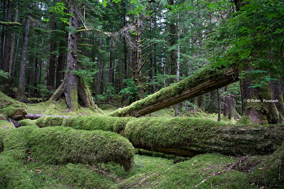
A raven on the dock at Masset, Haida Gwaii, June 2016. (Robin Rowland/Northwest Coast Energy News)
The object represents the first instance of a bird bone from a Neanderthal site bearing modifications that cannot be explained as the result of butchery activities.
That means the argument that bone notches are symbolic argument can be built on direct evidence.
The respect that British Columbia and Alaska First Nations have for the raven is found in countless legends and stories. Other cultures have honoured the raven including the Celtics who believed the raven was symbol of war, the Vikings and Greeks where the raven was a messenger of the gods, to name just a few.
The discovery of the raven bone in a Neanderthal cave may mean that the relationship with the raven is much more ancient than previously believed.
The paper says evidence of burials, collection of rare items, production of engraved and perforated objects, personal ornaments, pigment use, and the extraction of bird feathers and claws support the notion that Neanderthals engaged in symbolical behavior, independently from the influence of anatomically modern humans.
Neanderthal burials of infants, children, and adults have been reported at several sites throughout Europe and the Near East, some of which are associated with grave goods. Pigment use among Neanderthals dates back as far as between 200,000 to 250,000 years ago. Pigment use became a more widespread practice about 60,000 years ago.
A string of new discoveries have shown that Neanderthals regularly exploited birds. The activities conducted by Neanderthals that may reflect their involvement in symbolic activities have been found in Italy, in caves in Gibraltar, nine sites in France and one Croatia.
Those discoveries indicate that cut-marks and scraping marks on upper limb bones mean that feathers were purposely detached from the wings of seven different bird species, including the common raven and the red-billed chough (a red beaked and red legged crow that is sacred in Wales and Cornwall). Others were the white-tailed and golden eagles, two species of vulture, and an unidentified raptor.
The study says that removal of feathers and claws is interpreted as proof that these objects were used as personal ornaments by Neanderthalsm the study says. Feathers and claws do not survive archaeologically. So far, no clear modifications for suspending or threading the claws were found so far on bird talons, so up until now this was considered circumstantial evidence.
On the left is the notched raven bone from Zaskalnaya VI Neanderthal site, Crimea. center: experimental notching of a turkey bone; right: sequences of experimentally made notches compared to those from Zaskalnaya VI. (Francesco d’Errico)
As for the raven bone found in Crimea, the scientists say it is more probable that the Neanderthal took the decision of adding notches two and six, after completing the first set and realizing that its production left two gaps.
Two reasons may account for this action. The craftsman may have considered that, if made for functional reasons, i.e. to facilitate the grip of the object, the notches of the first set were not frequent and numerous enough to fulfill that function. Alternatively, he/she may have considered, irrespective of the possible functional reason behind the production of the
notches, that it was important to add two notches in order to create a visually more regular and consistent pattern.
The archaeologists conclude the artistic hypothesis more probable because adding the two very small and superficial notches added virtually nothing to the gripping power of the object`s surface.
The results of the study pinpoint that a clear effort has been put to reach the goal of producing not just random but instead equidistant notches, that would have been perceived as regularly spaced. This implies that the resulting pattern could have conveyed an information, not directly linked to the object function, communicating to the user, and likely other members of the Neanderthal group. In this respect the sequential notches on the ZSK raven bone represent the first case of bird bone use by Neanderthal for which a symbolic function can be argued on direct rather than circumstantial evidence.
The immune system genes that protected north coast First Nations from possibly dangerous local pathogens thousands of years ago likely increased their vulnerability to European diseases in the nineteenth century, resulting in the disastrous population crash, a new genetic study has discovered.
The study which included members of the Lax Kw’alaams and Metlakatla First Nations at Prince Rupert “opens a new window on the catastrophic consequences of European colonization for indigenous peoples in that part of the world,” the study authors said in a news release.
The study, published today in Nature Communications, looked at the genomes of 25 individuals who lived 1,000 to 6,000 years ago in what the study calls PRH—the Prince Rupert Harbour region– and 25 of their descendants who still live in the region today.
“This is the first genome-wide study – where we have population-level data, not just a few individuals – that spans 6,000 years,” said University of Illinois anthropology professor Ripan Malhi, who co-led the new research with former graduate student John Lindo (now a postdoctoral researcher at the University of Chicago) and Pennsylvania State University biology professor Michael DeGiorgio. Both studies were carried out with the consent and cooperation of the Coastal Tsimshian people.
The new study analyzes the “exome,” the entire collection of genes that contribute to a person’s traits.
The ruins of a Haida longhouse at Tanu. Smallpox and other diseases brought a catastrophic population crash among coastal First Nations in the nineteenth century. (Robin Rowland/Northwest Coast Energy News)
“Oral traditions and archaeological evidence to date have shown that there has been continuous aboriginal occupation of this region for more than 9,000 years. This study adds another layer of scientific data linking the actual ancestral human remains to their modern descendants through their DNA over a span of 6,000 years,” said Barbara Petzelt, a co-author of the study and a liaison to the Metlakatla community. “It’s exciting to see how this tool of DNA science adds to the larger picture of Coast Tsimshian pre- and post-contact history – without the taint of historic European observer bias.”
In the new study, the team found that variants of an immune-related gene that were beneficial to many of those living in the region before European contact proved disadvantageous once the Europeans arrived.
The genes, the human leukocyte antigen gene family, known as HLA, helps the body recognize and respond to pathogens, or disease causing bacteria and viruses.
The authors say the “the immunological history of the indigenous people of the Americas is undoubtedly complex.”
As people came to the American continents about 15,000 to 20,000 years ago “indigenous people adapted to local pathogens.”
Statistical analyses revealed that the ancient genes were under “positive selection” before European contact. Natural selection meant that those ancient people with genetic resistance to those local diseases had an advantage that resulted in the genes becoming part of the population.
But the study indicates “those adaptations would have proven useful in ancient times but not necessarily after European colonialists altered the environment with their pathogens, some of which may have been novel. Existing genetic variation as a result of adaptation before European contact could thus have contributed to the indigenous population decline after European contact.”
The “positive selection” genes found in the remains of ancient members of the Coast Tsimshian people, has been replaced by another gene among the modern descendants that “has been associated with a variety of colonization-era infectious diseases, including measles and tuberculosis, and with the adaptive immune response to the vaccinia virus, which is an attenuated form of smallpox,” the authors wrote.
One of the genes is “64 percent less common today among the Coast Tsimshian people than it was before original European contact, which is a dramatic decline,” Lindo said.
The modern Coast Tsimshian show a “reduction in ‘effective population size’ of 57 per cent,” the researchers reported.
“’Effective population size’ is a population genetic concept that is different from what we normally think of with census population size,” Malhi said in an e-mail to Northwest Coast Energy News. “It basically means that there was a large drop in genetic diversity after European contact that could have been due to disease, warfare or other things that would result in this large population decline.”
The dramatic die-off occurred roughly 175 years ago, about the time that European diseases were sweeping through the First Nations of British Columbia.
While some members of the Coast Tsimshian community have intermarried with people of European descent over the past 175 years, the genetic changes cannot be solely attributed to what geneticists call “admixture.” The timing coincides with the documented smallpox epidemics of the 19th Century and historical reports of large-scale population declines. A majority of the “European admixture in the population likely occurred after the epidemics,” the study says.
To guard against what the study called “false positives” the genomes were also compared to individuals in the 1,000 Genome Project including 25 Han Chinese from Beijing as well as other indigenous peoples in the Americas including the Maya, the Suruí do Pará people of Brazil and a sample of Anzick DNA from the 12,000 year old remains of a child found buried in Montana.
“First Nations history mainly consists of oral stories passed from generation to generation. Our oral history tells of the deaths of a large percentage of our population by diseases from the European settlers.
“Smallpox, for our area, was particularly catastrophic,” said Jocelynn Mitchell, a Metlakatla co-author on the study. “We are pleased to have scientific evidence that corroborates our oral history. As technology continues to advance, we expect that science will continue to agree with the stories of our ancestors.”
The same vulnerability for smallpox, measles and tuberculous likely also contributed to the vulnerability to influenza, Malhi told Northwest Coast Energy News “It is important to note that any of these infectious diseases (measles, tuberculosis, smallpox, flu) could have resulted in the patterns that we are seeing. We just provided a few possibilities but not all possibilities.”
The study says the project was made possible through the active collaboration of the Metlakatla and Lax Kw’alaams First Nations.
The first collaborative DNA study began in 2007 and 2008. The scientists visited the communities each year “to report the most recent DNA results and obtain feedback on the results.”
“The two communities agreed to allow DNA analysis of ancestral individuals recovered from archaeological sites in the region and currently housed at the Canadian Museum of History. During and after community visits and extensive consultation, a research protocol and informed consent documents—agreed on by the indigenous communities and researchers—was approved by the University of Illinois Institutional Review Board. All individuals signed an informed consent document.”
These results were reported to the community and the scientists continue to visit the First Nations to report on this and related studies.
The study is titled “A time transect of exomes from a Native American population before and after European contact” and appeared in the Nov. 15, 2016, edition of Nature Communications.
UPDATED with comments from District of Kitimat, Terrace and the Gitga’at Nation
A preliminary seismic hazard assessment by Natural Resources Canada has identified possible earthquake scenarios for the Douglas Channel near Hartley Bay, Terrace and Bella Bella.
The same studies indicate that while Kitimat may not be directly in a seismic zone prolonged earthquakes cause some damage in Kitimat depending on the earthquake and the condition of the soil in certain parts of the District. One model scenario says that in the event of a magnitude 8.0 earthquake off the west coast of Haida Gwaii, given certain soil conditions, there might actually be more damage in Kitimat than on the islands.
Susceptibility to landslides
That assessment, part of the overall the study by the Geological Survey of Canada indicates that the north coast of British Columbia from Prince Rupert to Bella Bella is likely face to “seismically induced ground failure”– mostly landslides.
Overall, the report says that on a scale of 1 to 6 (6 representing the highest
susceptibility), the majority of the west coast of BC “exhibits landslide susceptibility values of 5 to 6, which is significantly higher than the rest of Canada.”
Geological Survey of Canada map showing parts of Canada that are prone to landslides. The BC North Coast study area is outlined by the rectangle. (Geological Survey of Canada)
In British Columbia the landslides are most likely to be triggered by delayed melting of the annual snow pack, heavy rains, bank erosion and site loading and caused long-lasting damning of the river causing “damage to pipelines, rail, and forestry, as well as fish habitats.”
So far no recent landslides along the northern British Columbia coast are known to be caused by earthquakes, the reports say “the existence of numerous landslides strengthens the likelihood of seismically induced ground failures… due to the high levels of seismicity….it is expected that the increased likelihood of strong ground shaking (with long durations) will increase the landslide susceptibility.”
New studies
It was only after the 2012 Haida Gwaii earthquake and with what the Geological Survey of Canada calls “a growing number of on-going and planned infrastructure projects, BC’s north coast is emerging as a region of high strategic importance to Canada’s economy,” that studies began in area where “there has been minimal research to understand earthquake hazards.”
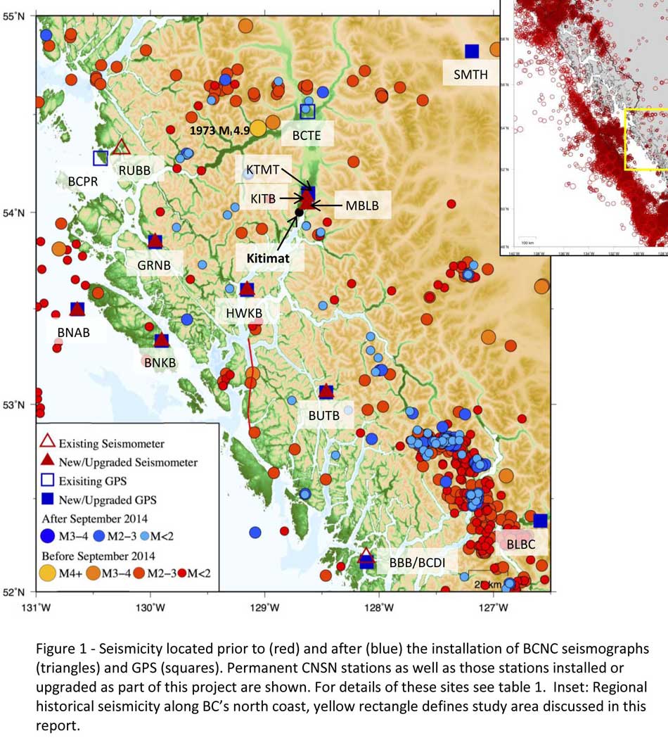
Now that studies have begun the Geological Survey has given the region its own new acronym BCNC (BC North Coast). Haida Gwaii is not part of BCNC, although earthquakes on those islands would likely impact the coast.
A Geological Survey of Canada map showing the BC North Coast region with earthquakes identified prior to and during recent studies. (Geological Survey of Canada)
The Geological Survey says that historically “the BCNC has been seismically quiescent.” As a result “seismic monitoring and research related to the BCNC has been minimal.” That meant while larger earthquakes were “felt and recorded,” the configuration of the Canadian National Seismograph Network did not allow earthquakes less than approximately magnitude 2.1 to be monitored in northern BC.
Now the Geological Survey is looking at “long-term, continuous monitoring of micro seismicity, combined with geodetic and paleo seismic techniques” that could be used to study at the possibility of large earthquakes, including a possible fault on the lower Douglas Channel.
Since the studies began in August 2014, the Geological Survey identified 145 earthquakes within the study area, many too small to be felt since they are less than magnitude 2.0. Those earthquakes, however, were picked up by the new and improved instrumentation used by the earthquake monitors.
The two reports one on “seismic hazards” and the second on “geohazards” says five “temporary seismonitors” (download reports from links below) were installed within the BCNC while some older stations were upgraded, saying, “It is expected that these new stations will be aid in locating small earthquakes” that were not previously detected by the existing network. The Geological Survey also installed ground movement monitoring GPS units along the coast.
The use of the term “temporary” raises the question about how much ongoing monitoring is planned.
The study also notes that the current data is not included in the seismic standards in the current National Building Code of Canada, which in turn is based on the Natural Resources Canada Seismic Hazard Map. That may mean that municipalities in the BC North Coast region, in the future, as the seismic studies continue, may have to consider updating building codes, especially in areas of “softer soils” as opposed to harder rock.
“Fault-like structure” on Douglas Channel
Detail of a map from the Geological Survey of Canada where the red line shows the 60 kilometre possible (still unconfirmed) fault line running from Gribbell Island to Princess Royal Island (Geological Survey of Canada)
Over the years some small earthquakes have also been recorded on what the Geological Survey calls the “recently mapped fault-like structure” on Douglas Channel which was discovered in 2012. The survey is still calling it “fault-like” because it has not yet been confirmed as an active fault. A new map in the study shows that the “fault” runs from the southern tip of Gribbell Island, down the centre of Whale Channel east of Gil Island and then along the western coast of Princess Royal Island.
The study identified “a small, unfelt swarm of earthquakes between magnitude 1.7 and 2.0 between September 13 and 14, 2010 near Gil Island.”
There is also the previously identified ancient Grenville Channel Fault (ancient and believed inactive because it dates from the Cretaceous, the age of the dinosaurs) that runs from along Grenville Channel from Porcher Island in the north to Klemtu in the south which has experienced small earthquakes.
The report says geological studies of the Douglas Channel “fault-like structure” are a priority because, “Should this structure be determined to be an active fault, it would pose significant risk of earthquake-triggered landslides (and subsequent tsunami) from the susceptible Douglas Channel hill slopes.”
Clay and sand in Kitimat
The report also calls for more studies the local geology and soil conditions in the Kitimat Valley. A study back in 1984 by John Clague of Simon Fraser University showed that as the glaciers retreated during the last Ice Age there were “periods of stagnation” resulting in sediments that are thicker than other regions of British Columbia, Clague reported that in parts of Kitimat, the glacial moraine is hundreds of metres thick.
After the glaciers were gone, the sea levels rose and glaciomarine sediments (clay, silt up to 60 metres thick) were deposited until the sea level fell to present-day levels. The report says that as these marine deposits were exposed to fresh water, salts were leached out resulting in saturated, porous sediments, including clay, which are prone to failure. Boreholes in the Kitimat area show that the clay and sediments above the bedrock can range from 17 metres to 106 metres.
The report notes the presence of clay soils “can amplify ground shaking and secondary effects” as happened in November 1988 when there was an earthquake in the Saguenay region of Quebec.
Originally reported as a 6.2 magnitude but later downgraded to 5.9, on Nov. 25, 1988, the major earthquake was centered near the Quebec cities of Chicoutimi and Jonquière, with aftershocks felt as far away as Toronto, Halifax and Boston. The quake lasted for two minutes, catching thousands of people off guard and leaving buildings damaged and power out for hundreds of thousands of Quebecers.
The report says the most significant event within the BC North Coast study region (which as mentioned doesn’t include Haida Gwaii) was a magnitude 4.9 earthquake approximately 20 kilometers southwest of Terrace on November 5, 1973, which was felt as far as 120 kilometers away, with some minor damage (broken windows and cracked plaster) reported near the epicentre. The main shock at Terrace was preceded by a magnitude 2.5 foreshock four hours before, and followed by a felt magnitude 3.7 aftershock the next day.
Bella Bella at risk
Another area most at risk, according to the report, is southern part of the BC North Coast zone, near Bella Bella, which is close to the northern section Cascadia Subduction Zone a “1,000 kilometre long dipping fault that stretches from Northern Vancouver Island to Cape Mendocino California” which one day will cause a major earthquake along the fault.
Cascadia subduction zone (USGS)
The report says that a magnitude 9.0 or higher earthquake in the northern Cascadia Subduction zone close to Bella Bella would be similar to the March 2011 earthquake in Japan and the 1964 Good Friday earthquake in Alaska.
For the northern part of the BC North Coast region, hazards could come from either a major earthquake off Haida Gwaii or a similar earthquake in south-eastern Alaska.
The greatest hazard would come from “long period” earthquakes greater than magnitude 6.75 with an epicentre between 300 and 350 kilometers away where the shaking lasts longer than one second.
The Geological Survey modeled three possible scenarios for major earthquakes in the BC North Coast Region.
Model #1. A magnitude 8.0 Earthquake at Haida Gwaii
The Geological Survey Canada model for an 8.0 magnitude earthquake west of Haida Gwaii. The possible damage is colour coded in the table below the map according to the Modified Mercalli Intensity Scale. The red polygon represents the area of possible rupture in the model with the star representing the epicentre. (Geological Survey of Canada)
The model looked at a “plausible maximum predicted” magnitude 8.0 thrust fault earthquake off the west coast of Haida Gwaii which would be twice as strong in the fault area as the 7.8 quake on October 28, 2012 (Remember Magnitudes are based on a logarithmic scale. That means for each whole number higher, the amplitude of the ground motion recorded by a seismograph goes up ten times so magnitude 8 earthquake would result in ten times the ground shaking as a magnitude 7 earthquake)
For a short period earthquake, the report estimates that there would be minimal damage on Haida Gwaii similar to the damage from the 2012 earthquake with little or no damage on the BC North Coast.
A long duration, long period earthquake that lasted longer than one second and up to three seconds or longer “may effect taller structures and trigger ground failure (that is liquefaction and lateral shaking).” Kitimat would feel that earthquake with the worst shaking in parts of the District with what the report calls “sensitive soils.” Coastal islands would feel double the amount of shaking as would occur in Kitimat.
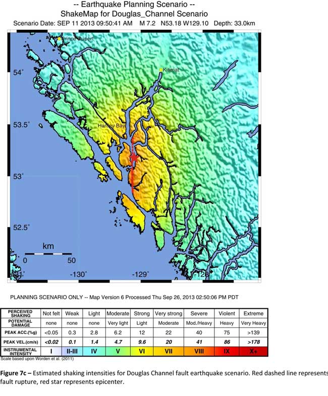
Model #2. A magnitude 7.2 Earthquake in Douglas Channel
The Geological Survey Canada model for a 7/2 magnitude earthquake in the lower Douglas Channel. The possible damage is colour coded in the table below the map according to the Modified Mercalli Intensity Scale. The red star represents the possible epicentre. (Geological Survey of Canada)
The second model looked at an earthquake in Douglas Channel based on the “fault like structure” if a slip strike rupture occurred along the entire 60 kilometers of the so far unconfirmed fault, resulting in a 7.2 magnitude earthquake. There would be very strong shaking within 20 kilometers radius of the epicentre, with moderate to heavy damage” in the relatively uninhabited islands, major shaking in Hartley Bay, resulting in very strong to strong damage at Hartley Bay and strong to moderate damage in Kitimat.
That earthquake, however, would be felt across the entire province of British Columbia. The report notes:
The expected effects and impacts of such an earthquake would mimic those of the 1946 magnitude 7.3 Vancouver Island earthquake, which occurred slightly west of Courtney and Campbell River. Shaking due to the 1946 earthquake was felt as far as Prince Rupert, BC to the north and Portland, Oregon to the south. In addition to knocking down 75 per cent of the chimneys in the local area, much of the earthquake-related damage was due to landslides, slumping and liquefaction
Model #3 A magnitude 6.3 Earthquake near Terrace
The Geological Survey Canada model for an 6.3 magnitude earthquake southwest of Terrace. The possible damage is colour coded in the table below the map according to the Modified Mercalli Intensity Scale. The red polygon represents the area of possible rupture in the model with the star representing the epicentre. (Geological Survey of Canada)
On May 11, 1973, a magnitude 4.7 shallow earthquake took place about 20 kilometers south west of Terrace, on the south side of the Skeena roughly across from the Shames mountain area. The earthquake was felt up to 120 kilometers away. The report says “The event has not been associated with any geologic features in the area and little is known about its rupture process.” The model estimated the results of a larger earthquake 6.3 magnitude in the same area. The model showed there would be strong to very strong shaking in Terrace, light to moderate shaking in Kitimat and light damage elsewhere in the BC North Coast. Most of the damage would be concentrated in a 20 kilometer zone around the epicentre.
The cause of the two failures is still unknown but the report says “their proximity to a nearby unmapped fault-like structure suggests that the slides could have been triggered by strong ground shaking from rupture along this structure.”
Another factor was the two well-known landslides occurred in the 1970’s in the Kitimat Arm which generated tsunamis but fortunately they occurred at low tide which decreased the impact. On October 17, 1974 a submarine slide generated a 2.8 metre tsunami. The following year on April 27, 1975, a slope failure on the northeast side of Kitimat Arm (which overlapped the 1974 failure area) displaced an estimated upper limit of 26,000,000 cubic metres of material.
“Watermark observations in Kitamaat Village estimated that the tsunami generated by this slide was up to 8.2 metres high.” The report says that while the trigger of the first event is unknown; the latter event coincided with nearby construction at that time. Modelling of the 1975 slide estimates that given the right conditions the generated tsunami waves could have been as high as 11 metres.
The report also notes that numerous landslides have also been mapped by the BC Department of Forestry in an attempt to improve safety measures for forestry workers.
The report says “The culmination of these studies brings awareness to the significant natural hazards present in the fragile coastal environment of the Coast Ranges.”
Another factor is the geology of the BC coast. The granitic mountains have rugged, steep slopes dissected by an intricate fjord system and dotted with islands of lower elevation. At lower elevations the land is covered by wet, coastal hemlock forests, which could be vulnerable to ground failures whereas higher elevations are characterized by barren rock or mountain hemlock subalpine.
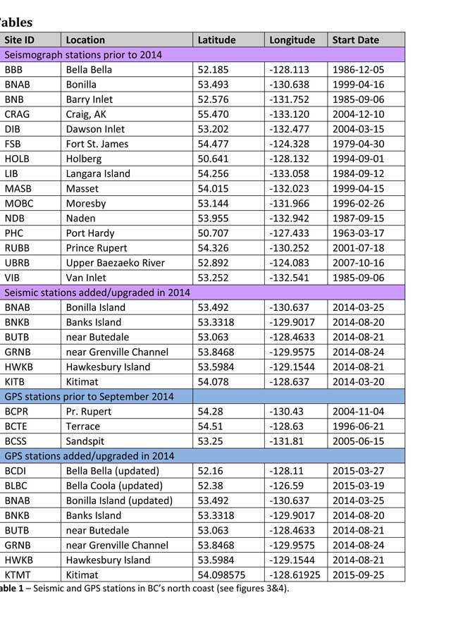
Table of Seismic monitoring and GPS stations in northern BC from the Geological Survey of Canada (Geological Survey of Canada)
The District of Kitimat said it has “not directly studied these issues but we are aware of potential hazards.” The development department has been advised of potential issues and site concerns.
A spokesperson for Terrace mayor Carol Leclerc told Northwest Coast Energy News in an e-mail. “I have reviewed it and distributed it to the relevant department heads. We are aware that historically Terrace has been at risk for experiencing seismic activity due to its location.”
The District of Kitimat did cooperate with National Resources in finding a location for their recently installed seismic equipment.
At Harley Bay, Gitga’at First Nation CEO Ellen Torng said the Gitga’at have been “ working with NRCan on their research in the Douglas Channel and in Hawksbury. NRC has been meeting with First Nations along the coast and have conducted community sessions on their research.
“We hosted one community session here in Hartley Bay and have regular updates from their technical team when they are in the area,” Torng said.
In addition, the District of Kitimat told Northwest Coast Energy News that Community Planning & Development department also provided local land information to geoscientists in the years leading up an international study called Batholiths on land in 2009.
Batholiths are large zones of molten rock that have solidified in the earth’s crust and are believed to play a key role in the formation and growth of continents. The Coast Mountain Range has a large concentration of batholiths, which means Kitimat was an excellent place to study the earth’s crust.
The project, which involved more than 50 scientists from nine Canadian and American universities, was set up to examine how mountain belts form and change over time and why continental mountain ranges are made of granite not basalt. Seismic imaging of the crust and mantle below the mountains required deploying thousands of seismic sensors and recorders, and recorded responses to several man-made detonations. Field work was completed in July 2009, and several scientific papers and dissertations have followed.
The Heiltsuk Nation was unable to respond to a request for comment due to the ongoing crisis from the sinking of the tug Nathan E. Stewart and the resulting spill of diesel fuel and other contaminants near Bella Bella.
Not felt except by a very few under especially favorable conditions.
II
Weak
Felt only by a few persons at rest,especially on upper floors of buildings.
III
Weak
Felt quite noticeably by persons indoors, especially on upper floors of buildings. Many people do not recognize it as an earthquake. Standing motor cars may rock slightly. Vibrations similar to the passing of a truck. Duration estimated.
IV
Light
Felt indoors by many, outdoors by few during the day. At night, some awakened. Dishes, windows, doors disturbed; walls make cracking sound. Sensation like heavy truck striking building. Standing motor cars rocked noticeably.
V
Moderate
Felt by nearly everyone; many awakened. Some dishes, windows broken. Unstable objects overturned. Pendulum clocks may stop.
VI
Strong
Felt by all, many frightened. Some heavy furniture moved; a few instances of fallen plaster. Damage slight.
VII
Very strong
Damage negligible in buildings of good design and construction; slight to moderate in well-built ordinary structures; considerable damage in poorly built or badly designed structures; some chimneys broken.
VIII
Severe
Damage slight in specially designed structures; considerable damage in ordinary substantial buildings with partial collapse. Damage great in poorly built structures. Fall of chimneys, factory stacks, columns, monuments, walls. Heavy furniture overturned.
IX
Violent
Damage considerable in specially designed structures; well-designed frame structures thrown out of plumb. Damage great in substantial buildings, with partial collapse. Buildings shifted off foundations.
X
Extreme
Some well-built wooden structures destroyed; most masonry and frame structures destroyed with foundations. Rails bent.
The September issue of National Geographic includes a large map of British Columbia it calls “Claiming British Columbia.”
(National Geographic)
The map has three themes: First Nations’ traditional territory, the routes of proposed pipeline projects, both LNG and diluted bitumen, and it features a sub map that looks at what the map calls the “Troubled Salmon” fishery.
The cartographers at National Geographic are being very careful, avoiding such troubling issues as competing land claims among First Nations, unresolved land claims with the federal and provincial governments and treaty status.
(National Geographic)(National Geographic)
So by and large the map groups First Nations by language group unless there are definite treaty or reserve boundaries. Large reserves under the Indian Act are on the map, but given the post stamp size of many reserves in British Columbia, those reserves are too small to be seen on the map. Towns and cities are identified as “First Nations” communities which often overlap with settler communities. Again the map misses many smaller communities, so Kitimat is on the map, while Kitamaat Village is not.
(National Geographic)
The map identifies Haisla traditional territory as “Xenaksilakala/Xa”islakala” and also includes the Kitlope Heritage Conservancy Protected area.
The article in the September issue is called The Pacific Coast, but unfortunately there is not much of a tie-in with the map, since it concentrates on California and Alaska with only a passing mention of British Columbia.
On the obverse side of the map is the poster that is promoted on the magazine cover, a beautiful painting of “The Changing Pacific Coast” which covers kelp and every creature from phytoplankton and zooplankton all the way to humpback whales and sea gulls (but for some reason no bald eagles). It is likely that poster will be on display in classrooms up and down the coast before school opens next week.
With climate change, the oceans are becoming more acid and that is a threat to the dungeness crab, according to a study by the US National Oceanic and Atmospheric Administration.
The study says ocean acidification expected to accompany climate change may slow development and reduce survival of the larval stages of Dungeness crab.
The dungeness crab is a key component of the Northwest marine ecosystem and vital to fishery revenue from Oregon to Alaska.
The research by NOAA Fisheries’ Northwest Fisheries Science Center in Seattle indicates that the declining pH anticipated in Puget Sound could jeopardize populations of Dungeness crab and put the fishery at risk. The study was recently published in the journal Marine Biology.
Ocean acidification occurs as the ocean absorbs carbon dioxide from the combustion of fossil fuels. Average ocean surface pH is expected to drop to about 7.8 off the West Coast by 2050, and could drop further during coastal upwelling periods.
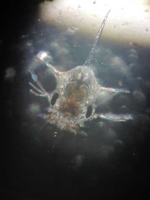
Survival of Dungeness crab larvae, called zoeae, declined at the lower pH levels expected with ocean acidification. (Jason Miller)
Dungeness crab is the highest revenue fishery in Washington and Oregon, and the second most valuable in California, although the fishery was recently closed in some areas because of a harmful algal bloom. The Dungeness crab harvest in 2014 was worth more than $80 million in Washington, $48 million in Oregon and nearly $67 million in California
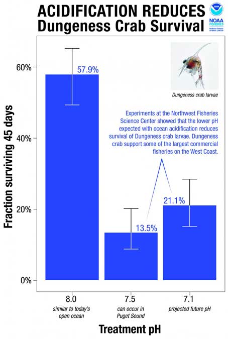
“I have great faith in the resiliency of nature, but I am concerned,” said Jason Miller, lead author of the research, which was part of his dissertation. “Crab larvae in our research were three times more likely to die when exposed to a pH that can already be found in Puget Sound, our own back yard, today.”
Scientists collected eggs from Dungeness crabs in Puget Sound and placed them in tanks at the NWFSC’s Montlake Research Laboratory. The tanks held seawater with a range of pH levels reflecting current conditions as well as the lower pH occasionally encountered in Puget Sound when deep water wells up near the surface. Larvae also went into tanks with the even lower-pH conditions expected with ocean acidification.
“The question was whether the lower pH we can expect to see in Puget Sound interferes with development of the next generation of Dungeness crab,” said Paul McElhany, a NOAA Fisheries research scientist and senior author of the paper. “Clearly the answer is yes. Now the question is, how does that play out in terms of affecting their life cycle and populations overall?”
Larvae hatched at the same rate regardless of pH, but those at lower pH took longer to hatch and progressed through their larval stages more slowly. Scientists suggested that the lower pH may reduce the metabolic rate of embryos. That could extend their vulnerable larval period, or could jeopardize the timing of their development in relation to key food sources, researchers suggested.
Larval survival also dropped by more than half at lower pH. At pH 8.0, roughly equivalent to seawater today, 58 percent of the crab larvae – called zoeae – survived for 45 days. At pH 7.5, which sometimes occurs in Puget Sound now, survival was 14 percent. At pH 7.1, which is expected to roughly approximate the pH of water upwelling on the West Coast with ocean acidification, zoeae survival remained low at 21 percent.
“Areas of greatest vulnerability will likely be where deep waters, naturally low in pH, meet acidified surface waters,” such as areas of coastal upwelling along the West Coast and in estuary environments such Hood Canal, the new study predicts.
The Environmental Protection Division of BC’s Ministry of Environment is launching a major study of the water quality in the Kitimat valley, first on the Kitimat River and some of its tributaries and later on the Kitimat Arm of Douglas Channel.
There has been no regular sampling by the province in Kitimat since 1995 (while other organizations such as the District of Kitimat have been sampling).
Jessica Penno, from the regional operations branch in Smithers, held a meeting for stakeholders at Riverlodge on Monday night. Among those attending the meeting were representatives of the District of Kitimat, the Haisla Nation Council, LNG Canada, Kitimat LNG, Rio Tinto BC Operations, Douglas Channel Watch, Kitimat Valley Naturalists and the Steelhead Society.
As the project ramps up during the spring and summer, the ministry will be looking for volunteers to take water samples to assist the study. The volunteers will be trained to take the samples and monitored to insure “sample integrity.” Penno also asked the District, the Haisla and the industries in the valley to collect extra samples for the provincial study and to consider sharing historical data for the study.
With the growing possibility of new industrial development in the Kitimat valley, monitoring water quality is a “high priority” for the province, Penno told the meeting. However, so far, there is no money targeted specifically for the project, she said.
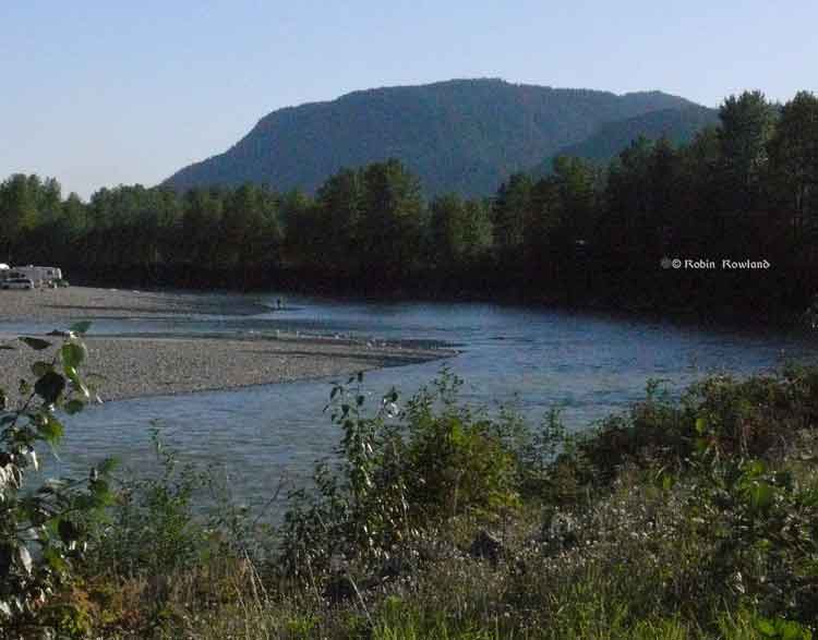
Camping and fishing on the Kitimat River. (Robin Rowland/Northwest Coast Energy News)
The purpose of the study is to make sure water in the Kitimat valley meet the provinces water quality objectives, which have the aim of watching for degradation of water quality, upgrade existing water quality or protect for designated uses such as drinking water, wildlife use, recreational use and industrial water supplies as well as protecting the most sensitive areas. It also provides a baseline for current and future environmental assessment. (In most cases, testing water quality for drinking water is the responsibility of the municipalities, Penno said. The province may warn a municipality if it detects potential problems, for example if a landslide increases metal content in a stream).
Under the BC Environment system, “water quality guidelines” are generic, while “water quality objectives” are site specific.
One of the aims is to compile all the studies done of the Kitimat River estuary by the various environmental impact studies done by industrial proponents.
The ministry would then create a monitoring program that could be effectively shared with all stakeholders.
At one point one member of the audience said he was “somewhat mystified” at the role of Fisheries and Oceans in any monitoring, noting that “when you phone them, nobody answers.”
“You mean, you too?” one of the BC officials quipped as the room laughed.
Water quality objectives
The last time water quality objectives were identified for the Kitimat River and arm were in the late 1980s, Penno told the meeting. The objectives were developed by the British Columbia government because of potential conflict between fisheries and industry at that time. The objectives were developed for the last ten kilometres of the Kitimat River and the immediate area around the estuary and the Kitimat Arm. “The Kitimat is one of the most heavily sport fished rivers in Canada,” she said.
However, the work at that time was only provisional and there was not enough water quality monitoring to create objectives that could be approved by the assistant deputy minister.
There has been no monitoring of the Kitimat River by BC Environment since 1995. “We’ve had a lot of changes in the Kitimat region, with the closure of Methanex and Eurocan, the modernization of Rio Tinto and potential LNG facilities.”
The main designated uses for the Kitimat River at that time were aquatic life, wildlife with secondary use for fishing and recreation.
She said she wants the stakeholders to identify areas that should be monitored at first on the river and the tributaries. Later in the summer, Environment BC will ask for suggestions for the estuaries of the Upper Kitimat Arm.
Participants expressed concern that the water supply to Kitamaat Village and the Kitimat LNG site at Bish Cove as well as Hirsch Creek and other tributaries should be included in the study. Penno replied that the purpose of the meeting was to identify “intimate local knowledge” to help the study proceed.
After a decade so of cuts, the government has “only so much capacity,” Penno said, which is why the study needs the help of both Kitimat residents and industry to both design the study and to do some of the sampling.
The original sampling station in the 1980s was at the Haisla Boulevard Bridge in Kitimat. A new sampling station has been added at the “orange” Kitimat River bridge on Highway 37. There is also regular sampling and monitoring at Hirsch Creek. The aim is to add new sampling points at both upstream and downstream from discharge points on the river.
The people at the meeting emphasized the program should take into consideration the Kitimat River and all its tributaries—if budget permits.
Spring freshette
Last year, the team collected five samples in thirty days in during four weeks in May and the first week in June, “catching the rising river quite perfectly” at previously established locations, at the Haisla Bridge and upstream and downstream from the old Eurocan site as well as the new “orange bridge” on the Kitimat River.
The plan calls for five samples in thirty days during the spring freshette and the fall rain and monthly sampling in between.
The stakeholders in the meeting told the enviroment staff that the Kitimat Valley has two spring freshettes, the first in March during the valley melt and later in May during the high mountain melt.
The plan calls for continued discussions with the industry stakeholders, Kitimat residents and the Haisla Nation.
The staff also wants the industrial stakeholders to provide data to the province, some of it going back to the founding of Kitimat if a way can be found to make sure all the data is compatible. One of the industry representatives pointed out, however, that sometimes data is the hands of contractors and the hiring company may not have full control over that data.
There will be another public meeting in the summer, once plans for sampling in the Kitimat Arm are ready.
Eel grass is not a seaweed but a flowering plant that migrated to the sea, say scientists who have now mapped the eel grass genome. The study also shows that eel grass ( Zostera marina) is crucial in absorbing carbon dioxide in the soft sediments of the coasts.
Eel grasses form a carbon dioxide sink: “they store more carbon than tropical forests,” says Jeanine Olsen of the University of Groningen in the Netherlands who led the study.
Coastal sea grass ecosystems cover some 200,000 square kilometers, the study says. Those ecosystems account for an estimated 15 per cent of carbon fixed in global ocean, and also impact sulphur and nitrogen cycles.
The scientists argue that since sea grasses are the only flowering plants to have returned to the sea that is the most extreme adaptation a terrestrial (or even freshwater) species can undergo.
The science team says the Zostera marina genome is “an exceptional resource that supports a wide range of research themes, from the adaptation of marine ecosystems under climate warming and its role in carbon burial to unraveling the mechanisms of salinity tolerance that may further inform the assisted breeding of crop plants.”
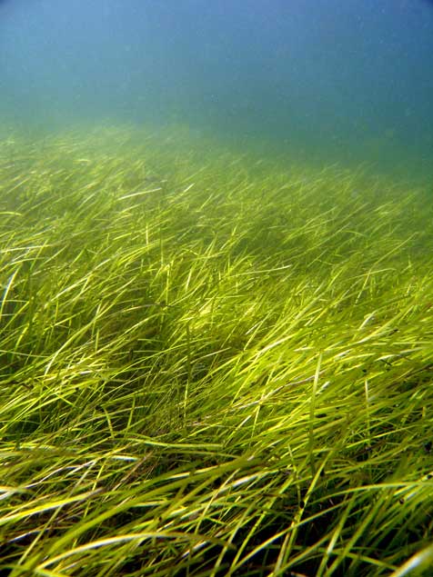
A seagrass meadow. (Christoffer Boström)
Sea grasses form the backbone of one of the most productive and biodiverse ecosystems on Earth, rivaling coral reefs and rain forests in terms of the ecosystem services they provide to humans.
Sea grass meadows are part of the soft-sediment coastal ecosystems found in all continents, with the exception of Antarctica. They not only form a nursery for young fish and other organisms, but also protect the coastline from erosion and maintain water clarity. ‘
The study, which sequenced the genome of the eel grass taken from the Archipelago Sea off Finland. published today, in the journal Nature, is the work of an international consortium of 35 labs, most of them in Europe, working with researchers from the U.S. Department of Energy Joint Genome Institute.
The study showed that eel grasses are completely submerged marine flowering plants, called by science angiosperms. It shows that eel grass is a member of the ancient monocot family.
The monocots include about 60,000 species, flowering plants that first appear above the soil as a single leaf. They include orchids, “true grasses,” as well as rice, wheat, maize and “forage grasses” such as sugar cane, and the bamboos. According to Wikipedia, other economically important monocot crops include palms bananas , gingers, onions, garlic, lilies, daffodils, irises, amaryllis, bluebells and tulips.
Zostera marina is the first marine flowering plant have its genome fully sequenced. As well as finding the eel grass’s genetic ancestors the researchers were interested in understanding how the plant–and by extension other plants in the ecosystem–adapt to climate change.
As it adapted to an underwater, coastal lifestyle, eel grass gained genes that allowed it to live in saltwater but lost genes involved in traits associated with land-based plants.
Olsen called this “arguably the most extreme adaptation a terrestrial (and even a freshwater) species can undergo.”
What she describes as the “use it, lose it, or change it” scenario, eelgrass modified its cell walls. The eel grass cell wall is very different from normal plant cell walls and more like that of sea algae, similar to the cell in seaweeds. The eel grass has lost genes associated with light-sensing, pollination and regulation of internal water balance.
Eel grass lost its stomata (which are used by land plants to ‘breathe’) but also all of the genes involved in stomatal differentiation. “The genes have just gone, so there’s no way back to land for sea grass,” Olsen says. Sex is entirely underwater involving long naked sperm filaments especially adapted for underwater fertilization of the tiny flowers.
The team compared the eel grass genome to duck weed, one of the simplest flowering plants and Zostera marina’s closest sequenced relative. They noted differences in genes related to cell wall structure due to adaptations to freshwater or terrestrial conditions. For example, plants such as duckweed have seemingly lost genes that help plants retain water in the cell wall, while eel grass has regained these genes to better deal with osmotic stress at low tide.
“They have re-engineered themselves,” said Olsen of the changes affecting the eelgrass cell walls. “Crop breeders may benefit from lessons on how salt tolerance has evolved in these plants.”
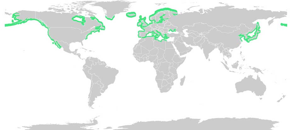
Eel grass distribution. (Wikipedia Commons(
With Zostera marina meadows stretching from Alaska to Baja California, and from the White Sea to southern Portugal, Olsen noted that these ecosystems afford researchers “a natural experiment to investigate rapid adaptation to warmer or colder waters, as well as to salinity tolerance, ocean acidification and light.”
Eel grass endangered
Jeremy Schmutz, head of the US Department of Energy’s genetic plant program, emphasized that while eel grasses are key players in coastal marine ecosystem functions and considered the “lungs of the sea,” they are also endangered. “There are estimates that nearly a third of the eel grass meadows worldwide have been destroyed by runoff into the ocean,” he said, “reducing their potential capabilities as carbon sinks. Thus, studying the adaptive capacity of eel grass is urgent to assist conservation efforts.”
An overarching question for Olsen’s team is how quickly eel grass can adapt to rapid climate change. The fact that Zostera marina grows along the coastline from Portugal to Scandinavia is being used as a natural experiment to investigate adaptation to warmer or colder water, as well as to salinity, ocean acidification and light.
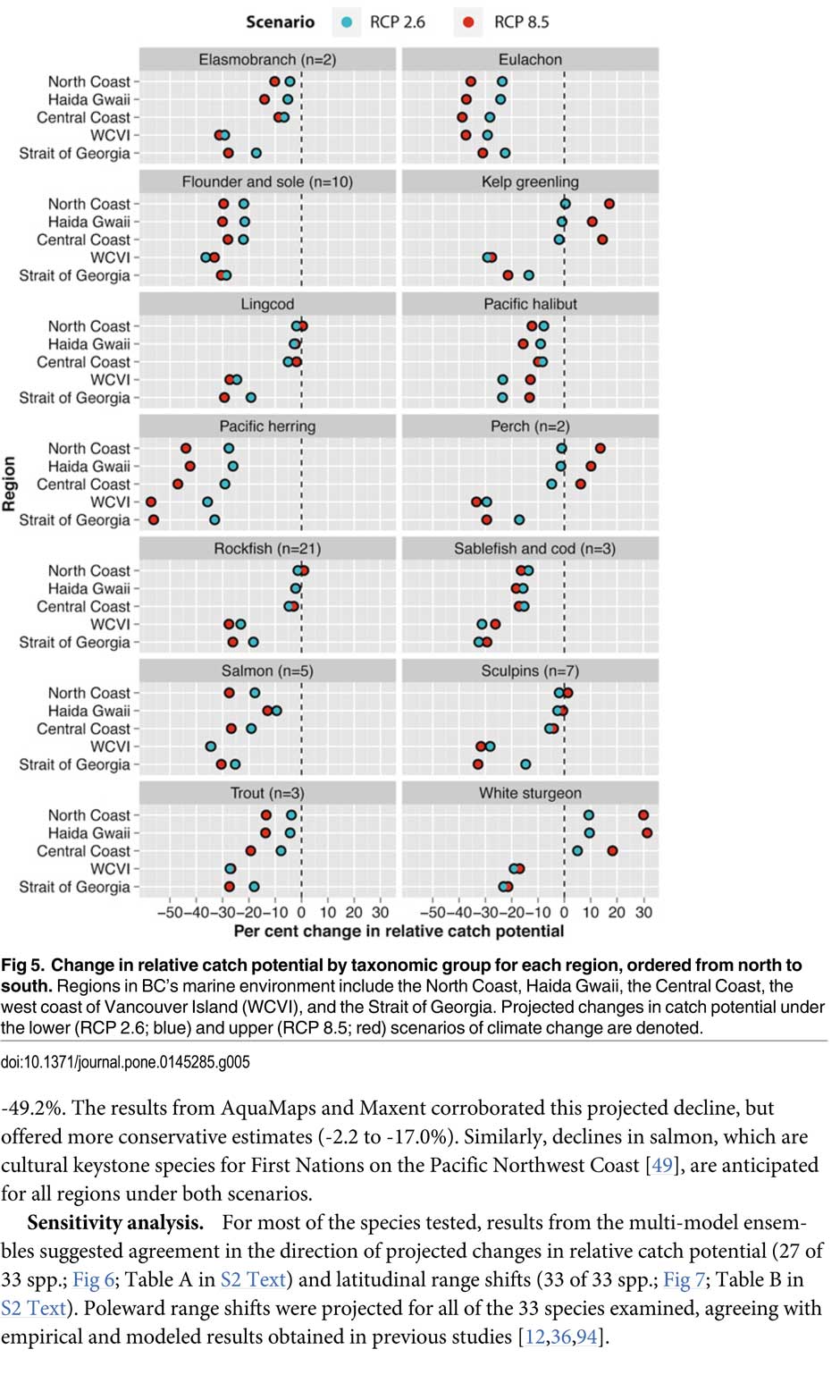
That’s one of the predictions from a new study from the University of British Columbia, looking at the future of the fishery on the coast.
The study concentrates on the First Nations fishery and warns that aboriginal people could face a catastrophic decline in the harvest of traditional species, especially salmon and herring roe on kelp over the next thirty years, a decline that will also have an equally devastating effect on commercial and recreational fishing.
The main cause of the decline is climate change and the warming of the coastal waters. The study projected “modest to severe declines in catch potential” for all current commercial fisheries along the coast.
The study says that for the First Nations the between $28 million to $36 million in revenue they got from fishing between 2001 and 2010 could fall by up to 90 per cent depending on how the climate changes.
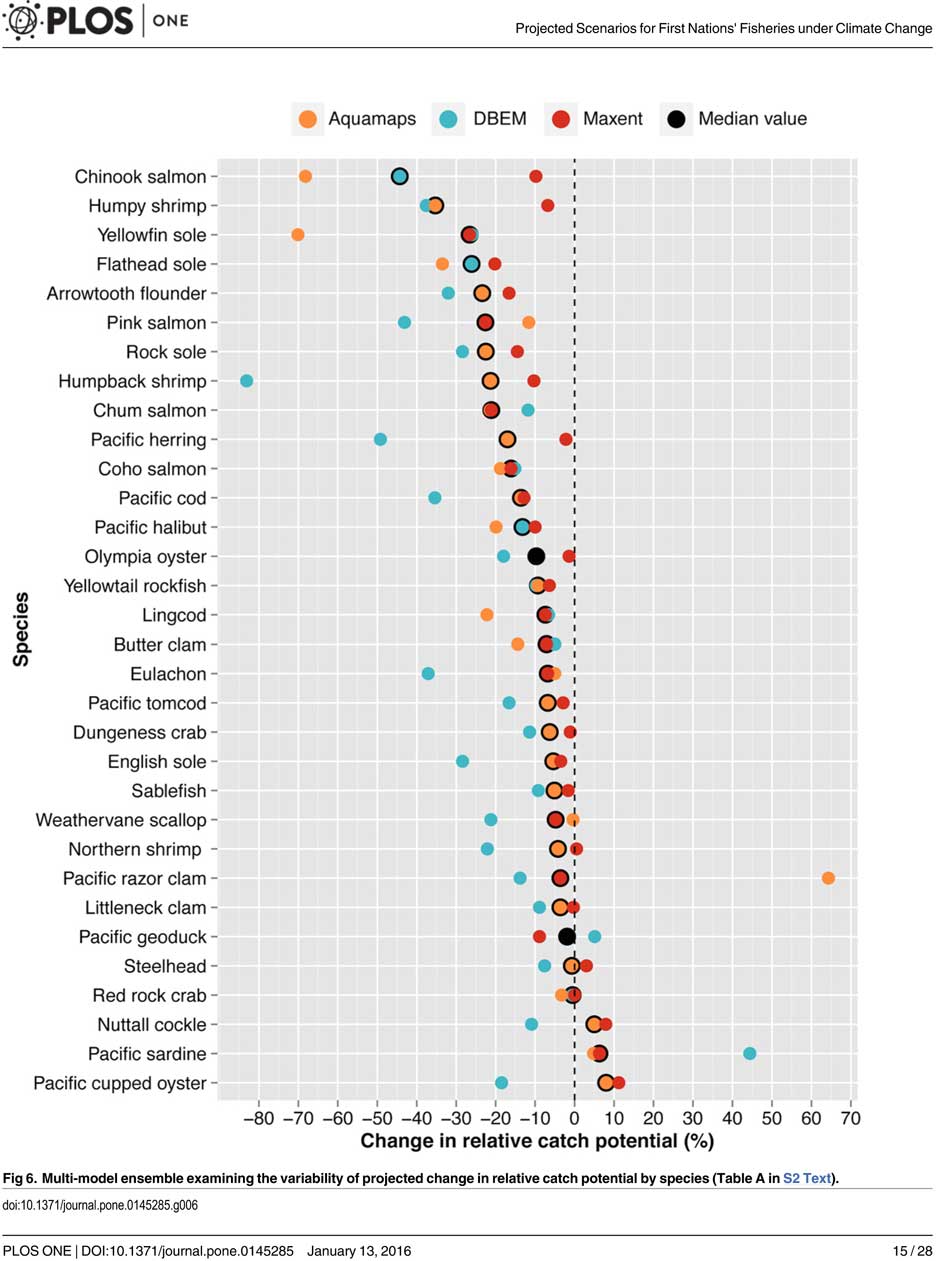
A chart from the UBC study shows possible decline in fish species under different climate scenarios. (PLOS1)
One scenario calls for a decline of up to 40 per cent in chinook and pink salmon.
If there is any good news, if you can call it that, the decline will be not as bad in northern coastal waters as it will be the warmer waters near the Lower Mainland and southern Vancouver Island. The range of some species, including salmon, herring, halibut and possibly oolichan will move to farther north along the BC Coast and into Alaskan waters.
That means in time the warming waters will also encourage an increase in other species, including sardines and some clams.
The changing oceans mean that “an increase in the relative abundance of warmer-water species was projected to lead to new or increased opportunities for commercial harvests by 2050.”
The study is urging the First Nations and other stakeholders in the British Columbia fishery to start long term planning immediately to anticipate changes in the coming decades.
The team of scientists led by Lauren Weatherdon, a graduate student at UBC, noted that while previous studies have looked at the impact of climate change on large-scale commercial fisheries, “few efforts have been made to quantitatively project impacts on small-scale subsistence and commercial fisheries that are economically, socially and culturally important to many coastal communities.”
The study was conducted in cooperation with the BC First Nations Fisheries Council and looked its seven coastal administrative regions “forming a sample of groups with diverse marine resources, geographical locations, territorial sizes, and treaty statuses.”
Within those regions 16 First Nations participated in the study, some under their treaty councils, including the Council of the Haida Nation, the Tsimshian Nations Treaty Society (including the Gitga’at at Hartley Bay and the Kitselas and Kitsumkalum near Terrace) and the Maa-nulth First Nations. The Heiltsuk First Nation at Bella Bella participated as an independent group.
The FNFC’s administrative regions intersect with five distinct ecological regions: the North Coast, comprising the Hecate Strait and Dixon Entrance; Haida Gwaii, which includes the waters surrounding the islands; the Central Coast, including Queen Charlotte Sound, Queen Charlotte Strait, and the southern tip of Hecate Strait; the Strait of Georgia; and the west coast of Vancouver Island (WCVI) .
The study says First Nations are likely to be exposed to different climate-related impacts on fisheries due to the differing ecological and biogeographical characteristics of these regions and to differing traditional and commercial harvests.
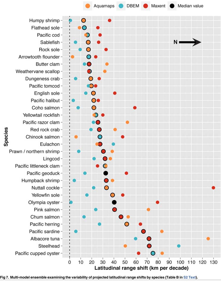
The study used a “dynamic bioclimate envelope” computer model to look at the changes to the distribution and relative abundances of the BC coastal species under two climate change scenarios, a high greenhouse gas model where society can’t curb emissions and a low greenhouse gas emission scenarios, depending on how society is able to curb the increase.
The study looked at ocean properties—including sea surface temperature, sea bottom temperature, salinity, oxygen concentration, surface action, and net primary production—using data from the US National Ocean and Atmospheric Administrations’ climate-related earth system model.
Climate change will mean that current species on the BC coast will “shift polewards.”
The study showed that by 2050, there could be declines in 87 of the 98 species in the study.
Greater losses in what the study calls “species richness” is likely to occur towards the southern coast of British Columbia, falling primarily between 48°N and 51°N. But, overall, species richness along coastal BC will continue—only with different species.
Most significantly the study projects a decline in the overall salmon catch from 17.1 per cent to 29.2 per cent, depending on the region and climate.
All aspects of the herring fishery, including roe herring, spawn-on-kelp, and the food and bait fishery could decline between 28.1 per cent and 49.2 per cent depending on the region.
The future of the oolichan is the most uncertain. One of the models studied projected a further 37.1 per cent decline in the oolichan, while other models called for for a decline between 5 per cent and 6.8 per cent. That will depend on how well, the oolichan already threatened in most regions of British Columbia are able to adapt to warmer waters or find a way to move their range northward.
The study says white sturgeon and Pacific sardines were projected to increase in abundance under both climate change scenarios, while manila clams were projected to increase in abundance by 14.5 per cent in one of the models. The eight remaining species showed little change.
The study suggests that the southern territories (Tsawwassen, Tla’amin, and Maa-nulth First Nations) will likely see a reduction in catch potential between -15.2 per cent and -27.8 per cent depending on how the climate changes.
On the north coast. The Haida and Tsimshian First Nations and those situated along the central or north-eastern coasts of Vancouver Island (Heiltsuk and ‘Namgis First Nations) would likely see smaller reductions in relative catch for each territory, with estimates falling between -3.2 per cent and -8.2 per cent.
The study shows that for the First Nations along the North and Central Coasts of British Columbia (Gitga’at and Haida, and Heiltsuk and ‘Namgis) there will be neutral or positive shifts in catch potential for white sturgeon, kelp greenling, and two species of perch under both scenarios.
While varying regionally, both scenarios also suggested either a slight cumulative decline or negligible change in catch potential for clams, rockfish, lingcod, and sculpins across the North and Central Coast.
One potential problem the study suggests is that fishers in southern British Columbia may, in the future, try to move north to follow the harvest, leading to potential conflicts. The cost of travel, may, however, discourage that.
One of the recommendations from the study is that First Nations revive the traditional clam gardens.
Traditional clam beds serve as an ideal example of a method that could be applied to offset climatic impacts through internalized mechanisms, using local cultivation to generate increased productivity by enhancing native habitat rather than redirecting extraction efforts towards other regions or species. Clam gardens constructed in a manner akin to those situated near ancient settlements of the Northern Coast Salish and Laich-kwil-tach First Nations have been found to generate higher clam densities, biomass, and growth rates than non-walled beaches . These benefits were observed for Pacific littleneck clams and butter clams , two clams that are of cultural, economic, and ecological importance to the region Reinstating clam beds in First Nations’ territorial lands has been suggested as a means of simultaneously achieving local conservation and cultural objectives and may thereby provide a politically and ecologically viable option for mitigating climate-related impacts.
The most important recommendation is that the First Nations and other stakeholders start cooperating immediately to offset how the changing climate with affect the fishery:
Management of salmon and herring stocks has been highly contentious due to the myriad of stakeholders who depend upon them, which include First Nations, recreational fisheries, and commercial fisheries….
Aside from fulfilling societal needs, salmon serve as key ecological components of the Pacific Northwest Coast, functioning as the mechanisms by which nutrients are transferred from the ocean to freshwater and terrestrial ecosystems
It says the projections show that a “redistribution of fishing effort” will not “fully offset declines in salmon and herring”
attaining a state of collaboration between First Nations, DFO, and other sectors has the potential to yield beneficial ecological and political results, if implemented correctly. Parallels exist between First Nations’ traditional fisheries management approaches and “modern” approaches (e.g., spatial management, mariculture, selective fishing, fishing closures), with differences arising primarily due to diverging worldviews.
It recommends local application of First Nations’ traditional management strategies to “provide opportunities to collaboratively engage in adaptive ecosystem-based management and to coordinate efforts to attain conservation objectives.”
They give an example of how the Nisga’a Nation have ensured their equal partnership in management by employing traditional fish wheel technology to monitor and assess stocks and by leveraging traditional ecosystem-based management practices that could be applied to plan long-term objectives and management approaches.
It concludes by saying that joint-management will not only work to reduce the impact of climate change but also head off potential conflict.
Through such joint-management regimes, traditional fisheries management strategies could be applied to advance localized research directives and to reduce impacts on stocks under unprecedented environmental change. Moreover, the risk of conflict over declining resources underlines the need to establish common and equitable ground to ensure successful joint management of fisheries, and to leverage collective expertise.
Chart from the study showing which fish species will move north up the coast as the climate changes. (PLOS1)
The B.C. government acted improperly and “breached the honour of the crown” when it signed away a provincial review and gave the federal Joint Review Panel for responsibility for assessing the environmental impact of the proposed Northern Gateway pipeline, Madam Justice Marvyn Koenigsberg of the Supreme Court of B.C. ruled Wednesday.
In a largely technical decision, Justice Koenigsberg ruled that British Columbia must come to its own decision on Northern Gateway. That’s because what is called the “equivalency agreement” that handed the decision over to the federal agency was not “was reasonable or correct for the Province to exercise its discretion.”
She ruled the equivalency agreement “is invalid” and said the project cannot begin until a provincial environmental assessment certificate has been issued.
“The province is required to consult with the Gitga’at about the potential impacts of the project on areas of provincial jurisdiction and about how those impacts may affect the Gitga’at’s aboriginal rights, and how those impacts are to be addressed in a manner consistent with the honour of the Crown and reconciliation,” Koenigsberg ruled.
That may be the final nail in the Northern Gateway’s coffin. The province opposed the project at the JRP because the Northern Gateway had not met the five conditions for heavy oil transport that was set down by the government.
The court ruling comes shortly after British Columbia told the National Energy Board that it also opposed the $6.8-billion Kinder Morgan TransMountain pipeline because, at this point, that project cannot meet BC’s five conditions.
B.C. Justice Minister Suzanne Anton said the province is reviewing the Supreme Court decision.
There are 19 more court challenges to the Northern Gateway and to the Joint Review process, most before the Federal Court of Canada.
The Gitga’at First Nation and Coastal First Nations which brought the suit in January 2015 say that the ruling means Enbridge pipeline must now face provincial environmental assessment decision, which includes consultation with First Nations across the province.
Northern Gateway says the federal decision stands, and its still working to meet the 209 conditions set out by the NEB, along with the B.C. government’s conditions.
“Northern Gateway and the project proponents, including Aboriginal Equity Partners, remain committed to this essential Canadian infrastructure,” Giesbrecht told the CBC.
But among the 209 conditions attached to the approval by the Joint Review Panel Condition 2 said that construction must begin before December 31, 2016. Under Conditions 20 and 21, Enbridge must have secured commitments for at least 60 per cent of the pipeline’s capacity at least six months before starting construction.
Enbridge still doesn’t have any customers and with the world price of oil below $40 US a barrel, the chances of getting customers are slim. In its most recent NEB filing on December 21, 2015, Enbridge stated, “Further to its filing of June 29, 2015, Northern Gateway has not executed firm [transportation service agreements] with its prospective shippers.”
Koenigsberg ‘s ruling doesn’t official stop the Northern Gateway as some are celebrating. Rather the decision means that British Columbia must set up its own review process and then come to a decision. That decision could, in theory, approve Northern Gateway with conditions just as the Joint Review Panel did.
The ruling, which is a major victory for the Gitga’at First Nation, means the equivalency agreement is invalid, that the government must now make its own environmental assessment decision regarding the Enbridge Northern Gateway pipeline, and that it must consult with and accommodate First Nations along the pipeline route about potential impacts to their Aboriginal rights and title.
“This is a huge victory that affirms the provincial government’s duty to consult with and accommodate First Nations and to exercise its decision-making power on major pipeline projects,” said Arnold Clifton, Chief Councillor of the Gitga’at First Nation.
“This ruling is an important victory for our communities and presents another hurdle to the Enbridge Northern Gateway pipeline,” said Chief Marilyn Slett, President of the Coastal First Nations. “It means the province must now sit down with First Nation communities across BC and find ways to address the severe and irreversible impacts of this project.”
The constitutional challenge was brought by the Gitga’at First Nation and the Coastal First Nations, and was argued by Joseph Arvay, Q.C., (and his colleagues Catherine Boies Parker and Tim Dickson at Farris LLP ) one of Canada’s pre-eminent constitutional lawyers and an expert in Aboriginal and administrative law.
“The province has been talking a lot about its opposition to oil pipelines in recent days,” said Art Sterritt, a member of the Gitga’at First Nation. “Now it must put its money where its mouth is and apply the same rigorous standards it advocated for during the Joint Review Panel process, while consulting with every single First Nation who would be affected by this project. We’ve said it before: The Enbridge Northern Gateway pipeline is dead.”
The ruling means that, until the province makes a decision on the Enbridge Northern Gateway pipeline and issues an Environmental Assessment Certificate, none of the approximately 60 permits, licenses and authorizations necessary for the project to proceed can be issued.
The District of Kitimat Friday afternoon lifted the boil water advisory declared during a heavy rain storm late last Saturday. The District says system flushing may result in some discoloured water, but it is safe to drink and the water should run clear quickly.
The precautionary boil water advisory issued on Sunday, October 11 has been lifted.
This advisory was issued by the District of Kitimat, with advice from Northern Health, after the extremely high flood levels in the Kitimat River caused an increase in turbidity in the municipal water supply. It has now been lifted after two consecutive sets of samples confirmed there was no total coliform or E.coli contamination in the potable water.
Chlorination was increased and maintained over the boil water advisory period and municipal crews flushed the water system to speed up removal of the turbid (cloudy) water. The flushing itself could result in some discoloration of the water but it is safe to drink without boiling. If your water is discoloured, let your cold water run until it clears.
The District of Kitimat apologizes for any concern or inconvenience this precautionary measure may have caused.