A study by two scholars at Simon Fraser University says that the Enbridge Northern Gateway project is much more hazardous to Kitimat harbour, Douglas Channel and the BC Coast than Enbridge has told the Joint Review Panel.
The study by Dr. Thomas Gunton, director of the School of Resource and Environmental Management at SFU and Phd student Sean Broadbent, released Thursday May 2, 2013 says there are major methodological flaws in the way Enbridge has analyzed the risk of a potential oil spill from the bitumen and condensate tankers that would be loaded (bitumen) or unloaded (condensate) at the proposed terminal at Kitimat.
Enbridge Northern Gateway responded a few hours after the release of the SFU study with a statement of its own attacking the methedology used by the two SFU scholars and also calling into question their motivation since Gunton has worked for Coastal First Nations on their concerns about the tanker traffic.
Combination of events
One crucial factor stands out from the Gunton and Broadbent study (and one which should be confirmed by independent analysis). The two say that Enbridge, in its risk and safety studies for the Northern Gateway project and the associated tanker traffic, consistently failed to consider the possibility of a combination of circumstances that could lead to either a minor or a major incident.
Up until now, critics of the Northern Gateway project have often acknowledged that Enbridge’s risk analysis is robust but has consistently failed to take into consideration the possibilty of human error.
As most accidents and disasters happen not due to one technical event, or a single human error, the SFU finding that Enbridge hasn’t taken into consideration a series of cascading events is a signficant criticism.
Overall the SFU study says there could be a tanker spill every 10 years, not once in 250 years, as calculated by Enbridge.
It also says there could be 776 oil and condensate spills from pipelines over 50 years, not 25 spills over 50 years as projected by Enbridge. (And the life of the project is estimated at just 30 years, raising the question of why the 50 year figure was chosen)
Enbridge track record
The study also bases its analysis of the possibility of a spill not on Enbridge’s estimates before the Joint Review Panel but on the company’s actual track record of pipeline spllls and incidents and concludes that there could be between one and 16 spills (not necessarily major) each year along the Northern Gateway pipeline.
Findings for Kitimat
Among the key findings for Kitimat from the SFU study are:
Enbridge said the possibility of tanker spill was 11.3 to 47.5 per cent over the 30 year life of project. The SFU study says the possibility of a spill within the 30 years is 99.9 per cent.
The SFU study says it is likely there will be a small spill at the Kitimat Enbridge terminal every two years.
The SFU study estimates that there will be eight tanker transits each week on Douglas Channel if the Northern Gateway project goes ahead and more if it is expanded. (This, of course, does not include LNG tankers or regular traffic of bulk carriers and tankers for Rio Tinto Alcan)
The SFU study says that while Endridge did study maneuverability of tankers, it paid little attention to stopping distance required for AfraMax, SuezMax tankers and Very Large Crude Carriers.
The SFU study says Enbridge inflated effectiveness of the proposed tethered tugs and maintains the company did not study ports and operations that use tethered tugs now to see how effective tethering is.
The SFU says Enbridge’s risk analysis covered just 233 nautical miles of the British Columbia coast, where as it should have covered entire tanker route both to Asia and California, raising the possibility of a tanker disaster outside British Columbia that would be tied to the Kitimat operation.
Based on data on tanker traffic in Valdez, Alaska, from 1978 to 2008, the SFU study estimates probability of a 1,000 barrel spill in Douglas Channel at 98.1 per cent and a 10,000 barrel spill at 74.2 per cent over 30 year Gateway life. The Valdez figures account for introduction of double hulls after Exxon Valdez spill in 1989 and notes that spill frequency is much lower since the introduction of double hulled tankers.
According to a study by Worley Parsons for Enbridge in 2012, the Kitimat River is the most likely area affected by an unconstrained rupture due to geohazards in the region. According to the Worley Parsons study, geohazards represent the most significant threat to the Northern Gateway pipeline system.
Flawed studies
The SFU scholars list a series of what they say are major methological or analytic flaws in the information that Enbridge has presented to the Joint Review Panel, concluding that “Enbridge significantly understates the risk of of spills from the Northern Gatway.
Enbridge’s spill risk analysis contains 28 major deficiencies. As a result of these deficiencies, Enbridge underestimates the risk of the ENGP by a significant margin.
Some of the key deficiencies include:
Failure to present the probabilities of spills over the operating life of the ENGP
Failure to evaluate spill risks outside the narrowly defined BC study area
Reliance on LRFP data that significantly underreport tanker incidents by between 38 and 96%.
Failure to include the expansion capacity shipment volumes in the analysis
Failure to provide confidence ranges of the estimates
Failure to provide adequate sensitivity analysis
Failure to justify the impact of proposed mitigation measures on spill likelihood
Potential double counting of mitigation measures
Failure to provide an overall estimate of spill likelihood for the entire ENGP
Failure to disclose information and data supporting key assumptions that were used to reduce spill risk estimates
Failure to use other well accepted risk models such as the US OSRA model
SFU reports that Enbridge provides separate estimates of the likelihood of spills for each of the three major components of the project:
tanker operations,
terminal operations,
the oil and condensate pipelines.
The SFU scholars say Enbridge does not combine the separate estimates to provide an overall estimate of the probability of spills for the entire project and therefore does not provide sufficient information to determine the likelihood of adverse environmental effects……
It notes that “forecasting spill risk is challenging due to the many variables impacting risk and the uncertainties in forecasting future developments affecting risk. To improve the accuracy of risk assessment, international best practices have been developed.”
Part of the problem for Enbridge may be that when the company appeared before the Joint Review Panel it has repeatedly said that will complete studies long after approval (if the project is approved), leaving large gaps in any risk analysis.
The SFU study may have one example of this when it says Enbridge did not complete any sensitivity analysis for condensate spills at Kitimat Terminal or the condensate pipeline.
Our experts have identified a number of omissions, flawed assumptions and modeling errors in the study and have serious concerns with its conclusions:
The spill probability numbers are inflated: The author uses oil throughput volumes that are nearly 40 per cent higher than those applied for in this project which also inflates the number of tanker transits using these inflated volumes
The pipeline failure frequency methodology adopted by Mr. Gunton is flawed, and does not approximate what would be deemed a best practices approach to the scientific risk analysis of a modern pipeline system
Mr. Gunton based his failure frequency analysis on a small subset of historical failure incident data. Why would he limit the source of his data to two pipelines with incidents not reflective of the industry experience and not reflective of the new technology proposed for Northern Gateway?
The study results are not borne out by real world tanker spill statistics. Based on Mr. Gunton’s estimates we should expect 21 to 77 large tanker spills every year worldwide while in reality after 2000 it has been below 3 per year and in 2012 there were zero.
Most of Enbridge’s rebuttal is a personal attack on Gunton, noting
We are very concerned about the misleading report released by Mr. Gunton, who was a witness for the Coastal First Nations organization during the Northern Gateway Joint Review Panel process.
Mr. Gunton should have made his study available to the JRP process, the most thorough review of a pipeline that’s ever taken place in Canada. All of Northern Gateway’s conclusions have been subject to peer review, information requests and questioning by intervenors and the Joint Review Panel.
In response, Gunton told the Globe and Mail “the report took over a year to complete and it was not ready in time to be submitted as evidence before the federal Joint Review Panel which is now examining the proposed pipeline.”
Enbridge’s statement also ignores the fact under the arcane rules of evidence, any study such as the one from Simon Fraser had to be submitted to the JRP early in the process, while evidence was still being submitted.
The recent ruling by the JRP for closing arguments also precludes anyone using material that was not entered into evidence during the actual hearings.
That means that the SFU study will be ignored in the final round of the Joint Review Panel, which can only increase the disillusionment and distrust of the process that is already common throughout northwest British Columbia.
“There is no need to scare people,” about tankers, Transport Minister Denis Lebel told the House of Commons on Thursday, March 28.
Lebel was answering a question from Skeena Bulkley Valley MP and NDP House Leader Nathan Cullen.
The official transcript from Hansard records Cullen’s question about the federal government’s unexpected declaration that Kitimat would become a public port.
Mr. Speaker, last week, in their panic to ram a bitumen pipeline through to British Columbia’s north coast, the Conservatives simply decreed that they would take over the Port of Kitimat. Rather than picking up the phone and talking with the local council or the Haisla Nation, the government parachuted in a minister from Toronto to make the announcement. There was no consultation, no respect, just bulldozers.
We see again the fundamental disrespect the government has for first nations here today. Now the Conservatives are scrambling, saying that they will consult after they have clearly made up their minds, the exact approach they take on the pipeline. When will the government start to respect the people of the northwest?
Lebel replied in French, and as is usual in Question Period did not answer Cullen’s question.
Mr. Speaker, last week we announced the creation of an expert panel. These people will work together to think of how to improve things.
We have a very good system for dealing with oil spills. We will continue to move forward and keep everyone safe.
Canada has not had any major oil spills in its history. There is no need to scare people. We will continue to work on measures.
I thank all members of the panel led by Mr. Houston for their ability to find solutions.
This Youtube video shows Cullen’s question and Lebel’s response. The live translation is a little different, but the effect is the same.
Cullen later issued a news release commenting
Cullen’s question came on the heels of reports that neither Kitimat Council nor the Haisla Nation were consulted in advance of the federal government’s decision to take over the Kitimat port. The move represents an apparent ongoing tendency by the Conservative federal government to offer consultation with communities and First Nations, but only after they’ve already made their decision.
Cullen later reflected that, regardless of one’s position on the Northern Gateway pipeline, open and prior consultation is crucial to fostering good governance and the trust of the general public. By contrast, said Cullen, “the Conservatives are writing the book on how to ignore communities and First Nations, and damage public faith. This is just the latest chapter.”
a large, relatively shallow lake in south-central Quebec, Canada, in the Laurentian Highlands. It is situated 206 kilometres north of the Saint Lawrence River, into which it drains via the Saguenay River. It covers an area of 1,053 km2 (407 sq mi), and is 63.1 m (207 ft) at its deepest point.
It is unlikely there will ever be a Very Large Crude Carrier on Lac St. Jean.
In its earliest statements the Harper Conservatives were careful to say that there had never been a tanker disaster on the west coast. Now, in its Orwellian fashion, the government is now saying “Canada has not had any major oil spills in its history.”
That statement, of course, ignores the Arrow tanker disaster off Chedabucto Bay, Nova Scotia on February 4, 1970, which the Environment Canada website, (as of April 1, 2013), describes this way
the calamity had reached catastrophic proportions. Out of the 375 statute miles of shoreline in the Bay area, 190 miles had been contaminated in varying degrees.
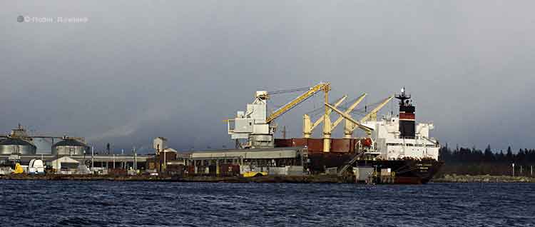
The Panama registered bulk carrier Azuma Phoenix is seen tied up at Kitimat harbour on the afternoon of Jan 9, 2012. In March 2013. the federal government announced it was making the private port of Kitimat into a public port. (Robin Rowland)
When the story of the Stephen Harper government is told, historians will say that the week of March 17 to 23, 2013, is remembered, not for the release of a lacklustre federal budget, but for day after day of political blunders that undermined Harper’s goal of making a Canada what the Conservatives call a resource superpower.
It was a week where spin overcame substance and spun out of control.
The Conservative government’s aim was, apparently, to increase support for the Enbridge Northern Gateway pipeline project with a spin campaign aimed at moving the middle ground in British Columbia from anti-project to pro-project and at the same time launching a divide and conquer strategy aimed at BC and Alberta First Nations.
It all backfired. If on Monday, March 17, 2013, the troubled and controversial Enbridge Northern Gateway project was on the sick list, by Friday, March 23, the Enbridge pipeline and tanker scheme was added to the Do Not Resuscitate list, all thanks to political arrogance, blindfolded spin and bureaucratic incompetence. The standard boogeymen for conservative media in Canada (who always add the same sentence to their stories on the Northern Gateway) “First Nations and environmentalists who oppose the project” had nothing to do with it.
Stephen Harper has tight control of his party and the government, and in this case the billion bucks stop at the Prime Minister’s Office. He has only himself to blame.
All of this happened on the northern coast of British Columbia, far out of range of the radar of the national media and the Ottawa pundit class (most of whom, it must be admitted, were locked up in an old railway station in the nation’s capital, trying interpret Finance Minister Jim Flaherty’s spreadsheets).
The story begins early on that Monday morning, at my home base in Kitimat, BC, the proposed terminal for Northern Gateway, when a news release pops into my e-mail box, advising that Natural Resources Minister Joe Oliver would be in nearby Terrace early on Tuesday morning for an announcement and photo op.
I started making calls, trying to find out if anyone in Kitimat knew about Oliver’s visit to Terrace and if the minister planned to come to Kitimat.
Visitors to Kitimat
I made those calls because in the past two years, Kitimat has seen a parade of visitors checking out the town and the port’s industrial and transportation potential. The visitors range from members of the BC provincial Liberal cabinet to the staff of the Chinese consulate in Vancouver to top executives of some of the world’s major transnational corporations (and not just in the energy sector). Most of these visits, which usually include meetings with the District of Kitimat Council and District senior staff as well as separate meetings with the Council of the Haisla Nation, are usually considered confidential. There are no photo ops or news conferences. If the news of a visit is made public, (not all are), those visits are usually noted, after the fact, by Mayor Joanne Monaghan at the next public council meeting.
It was quickly clear from my calls that no one in an official capacity in Kitimat knew that, by the next morning, Oliver would be Terrace, 60 kilometres up Highway 37. No meetings in Kitimat, on or off the record, were scheduled with the Minister of Natural Resources who has been talking about Kitimat ever since he was appointed to the Harper cabinet.
I was skeptical about that afternoon’s announcement/photo op in Vancouver by Transport Minister Denis Lebel and Oliver about the “world class” tanker monitoring.
After all, there had been Canadian Coast Guard cutbacks on the northwest coast even before Stephen Harper got his majority government. The inadequacy of oil spill response on the British Columbia coast had been condemned both by former Auditor General Sheila Fraser and in the United States Senate. The government stubbornly closed and dismantled the Kitsilano Coast Guard station. It’s proposing that ocean traffic control for the Port of Vancouver be done remotely from Victoria, with fixed cameras dotted around the harbour. Leaving controllers in Vancouver would, of course, be the best solution, but they must be sacrificed (along with any ship that get’s into trouble in the future, on the altar of a balanced budget).
The part of the announcement that said there would be increased air surveillance is nothing more than a joke (or spin intended just for the Conservative base in Alberta, Saskatchewan and the Toronto suburbs,that is not anyone familiar with BC coastal waters). Currently the Transport Canada surveillance aircraft are used on the coasts to look for vessels that are illegally dumping bilge or oil off shore. As CBC’s Paul Hunter reported in 2010, Transport Canada aircraft were used after the Gulf of Mexico oil disaster to map where the oil was going after it erupted from the Deepwater Horizon.
Given the stormy weather on the west coast (when Coast Guard radio frequently warns of “hurricane force winds”) it is highly unlikely that the surveillance aircraft would even be flying in the conditions that could cause a major tanker disaster. Aerial surveillance, even in good weather, will never prevent a tanker disaster caused by human error.
I got my first chance to look at the Transport Canada website in late afternoon and that’s when a seemingly innocuous section made me sit up and say “what is going on?” (I actually said something much stronger).
Public port
Public port designations: More ports will be designated for traffic control measures, starting with Kitimat.
(Transport Canada actually spelled the name wrong—it has since been fixed—as you can see in this screen grab).
Kitimat has been one of the few private ports in Canada since the Alcan smelter was built and the town founded 60 years ago (the 60th anniversary of the incorporation of the District of Kitimat is March 31, 2013).
The reasons for the designation of Kitimat as a private port go back to a complicated deal between the province of British Columbia and Alcan in the late 1940s as the two were negotiating about electrical power, the aluminum smelter, the building of the town and the harbour.
For 60 years, Alcan, later Rio Tinto Alcan, built, paid for and operated the port as a private sector venture. For a time, additional docks were also operated by Eurocan and Methanex. After Eurocan closed its Kitimat operation that dock was purchased by the parent company Rio Tinto. The Methanex dock was purchased by Royal Dutch Shell last year for its proposed LNG operation.
The announcement that Kitimat was to become a public port was also something that the national media would not recognize as significant unless they are familiar with the history of the port. That history is known only to current and former residents of Kitimat and managers at Rio Tinto Alcan.
The port announcement came so much out of left field; so to speak, that I had doubts it was accurate. In other words, I couldn’t believe it. I went to Monday evening’s meeting of District of Kitimat Council and at the break between the open and in-camera sessions, I asked council members if they had heard about Kitimat being redesignated a public port. The members of the district council were as surprised as I had been.
Back from the council meeting, I checked the Transport Canada news release and backgrounders. I also checked the online version of Bill C-57, the enabling act for the changes announced earlier that day. There was no mention of Kitimat in Bill C-57.
Tuesday morning I drove to Terrace for Joe Oliver’s 9 am photo op and the announcement at Northwest Community College (NWCC) that the government had appointed Douglas Eyford as a special envoy to First Nations for energy projects, an attempt on the surface to try and get First Nations onside for the pipeline projects, an appointment seen by some First Nations leaders as an attempt by the Harper government to divide and conquer.
As an on site reporter, I got to ask Oliver two questions before the news conference went to the national media on the phones.
In answer to my first question, Oliver confirmed that the federal government had decided to make Kitimat a public port, saying in his first sentence: “What the purpose is to make sure that the absolute highest standards of marine safety apply in the port of Kitimat.” He then returned to message track saying, “we have as I announced yesterday and I had spoken about before at the port of Vancouver we have an extremely robust marine safety regime in place but we want to make sure that as resource development continues and as technology improves, we are at the world class level. As I also mentioned there has never been off the coast of British Columbia a major tanker spill and we want to keep that perfect record.”
For my second question, I asked Oliver if he planned to visit Kitimat.
He replied. “Not in this particular visit, I have to get back [to Ottawa] There’s a budget coming and I have to be in the House for that but I certainly expect to be going up there.”
The question may not have registered with the national media on the conference call. For the local reporters and leaders in the room at Waap Galts’ap, the long house at Terrace’s Northwest Community College, everyone knew that Kitimat had been snubbed.
Back in Kitimat, I sent an e-mail to Colleen Nyce, the local spokesperson for Rio Tinto Alcan noting that Joe Oliver had confirmed that the federal government intended to make the RTA-run port a public port. I asked if RTA had been consulted and if the company had any comment.
Nyce replied that she was not aware of the announcement and promised to “look into this on our end.” I am now told by sources that it is believed that my inquiry to Nyce was the first time Rio Tinto Alcan, one of Canada’s biggest resource companies, had heard that the federal government was taking over its port.
The next day, Kitimat Mayor Joanne Monaghan told local TV news on CFTK the Kitimat community was never consulted about the decision and she added that she still hadn’t been able to get anyone with the federal government to tell her more about the plan.
Who pays for the navigation aids?
Meanwhile, new questions were being raised in Kitimat about two other parts of the Monday announcement.
New and modified aids to navigation: The CCG will ensure that a system of aids to navigation comprised of buoys, lights and other devices to warn of obstructions and to mark the location of preferred shipping routes is installed and maintained. Modern navigation system: The CCG will develop options for enhancing Canada’s current navigation system (e.g. aids to navigation, hydrographic charts, etc) by fall 2013 for government consideration.
Since its first public meeting in Kitimat, in documents filed with the Northern Gateway Joint Review Panel, in public statements and advertising, Enbridge has been saying for at least the past four years that the company would pay for all the needed upgrades to aids to navigation on Douglas Channel, Wright Sound and other areas for its tanker traffic. It is estimated that those navigation upgrades would cost millions of dollars.
Now days before a federal budget that Jim Flaherty had already telegraphed as emphasizing restraint, it appeared that the Harper government, in its desperation to get approval for energy exports, was going to take over funding for the navigation upgrades from the private sector and hand the bill to the Canadian taxpayer.
RTA not consulted
On Thursday morning, I received an e-mail from Colleen Nyce with a Rio Tinto Alcan statement, noting:
This announcement was not discussed with Rio Tinto Alcan in advance. We are endeavoring to have meetings with the federal government to gain clarity on this announcement as it specifically relates to our operations in Kitimat.
On Friday morning, Mayor Monaghan told Andrew Kurjata on CBC’s Daybreak North that she had had at that time no response to phone calls and e-mails asking for clarification of the announcement. Monaghan also told CBC that Kitimat’s development officer Rose Klukas had tried to “get an audience with minister and had been unable to.” (One reason may be that Oliver’s staff was busy. They ordered NWCC staff to rearrange the usual layout of the chairs at Waap Galts’ap, the long house, to get a better background for the TV cameras for Oliver’s statement).
Natural Resources Minister Joe Oliver (front far right) answers questions after his news conference at the Northwest Community College Long House, March 19, 2013. (Robin Rowland)
Monaghan told Kurjata, “I feel like it’s a slap in the face because we’re always being told that we’re the instrument for the whole world right now because Kitimat is supposed to be the capital of the economy right now. So I thought we’d have a little more clout by now and they’d at least tell us they were going to do this. There was absolutely no consultation whatsoever.”
By Friday afternoon, five days after the announcement, Transport Canada officials finally returned the calls from Mayor Monaghan and Rose Klukas promising to consult Kitimat officials in the future.
Monaghan said that Transport Canada told her that it would take at least one year because the change from a private port to a public port requires a change in legislation.
Transport Canada is now promising “extensive public and stakeholder consultation will occur before the legislation is changed,” the mayor was told.
On this Mayor Monaghan commented, “It seems to me that now they want to do consultation….sort of like closing the barn door after all of the cows got out!”
Blunder No 1. Pulling the rug out from Northern Gateway
Joe Oliver and the Harper government sent a strong political signal to Kitimat on Tuesday; (to paraphrase an old movie) your little town doesn’t amount of a hill of beans in this crazy world.
There are a tiny handful of people in Kitimat openly in favour of the Northern Gateway project. A significant minority are on the fence and some perhaps leaning toward acceptance of the project. There is strong opposition and many with a wait and see attitude. (Those in favour will usually only speak on background, and then when you talk to them most of those “in favour” have lists of conditions. If BC Premier Christy Clark has five conditions, many of these people have a dozen or more).
Oliver was speaking in Terrace, 60 kilometres from Kitimat. It is about a 40 to 45 minute drive to Kitimat over a beautiful stretch of highway, with views of lakes, rivers and mountains.
Scenic Highway 37 is the route to the main location not only for the controversial Northern Gateway pipeline but three liquefied natural gas projects, not to mention David Black’s proposed refinery half way between Terrace and Kitimat.
Why wouldn’t Kitimat be a must stop on the schedule for the Minister of Natural Resources? In Terrace, Oliver declared that Kitimat was to become a public port, run by the federal government. Although technically that would be the responsibility of Denis Lebel, the Minister of Transport, one has to wonder why the Minister of Natural Resources would not want to see the port that is supposedly vital to Canada’s economy? You have to ask why he didn’t want to meet the representatives of the Haisla Nation, the staff and council of the District of Kitimat and local business leaders?
Oliver has been going across Canada, the United States and to foreign countries promoting pipelines and tanker traffic, pipelines that would terminate at Kitimat and tankers that would send either bitumen or liquefied natural gas to customers in Asia.
Yet the Minister of Natural Resources is too important, too busy to take a few hours out of his schedule, while he is in the region, to actually visit the town he has been talking about for years.
He told me that he had to be in Ottawa for the budget. Really? The budget is always the finance minister’s show and tell (with a little help from whomever the Prime Minister is at the time). On budget day, Oliver would have been nothing more than a background extra whenever the television cameras “dipped in” on the House of Commons, between stories from reporters and experts who had been in the budget lockup.
According to the time code on my video camera, Oliver’s news conference wrapped at 9:50 a.m., which certainly gave the minister and his staff plenty of time to drive to Kitimat, meet with the representatives of the District, the Haisla Nation and the Chamber of Commerce and still get to Vancouver for a late flight back to Ontario.
On Tuesday, Joe Oliver’s snub pulled the political rug out from under the Northern Gateway supporters and fence sitters in Kitimat. Oliver’s snub showed those few people in Kitimat that if they do go out on a limb to support the Northern Gateway project, the Conservatives would saw off that limb so it can be used as a good background prop for a photo op.
Prince Rupert, Terrace and Smithers councils have all voted against the Northern Gateway project. Kitimat Council, despite some clear divisions, has maintained a position of absolute neutrality. Kitimat Council will continue to be officially neutral until after the Joint Review report, but this week you could hear the air slowly leaking out of the neutrality balloon.
Oliver may still believe, as he has frequently said, that the only people who oppose Northern Gateway are dangerous radicals paid by foreign foundations.
What he did on Tuesday was to make the opposition to Northern Gateway in Kitimat into an even more solid majority across the political spectrum.
Blunder No 2. Rio Tinto Alcan
It doesn’t do much for the credibility of a minister of natural resources to thoroughly piss off, for no good reason, the world’s second largest mining and smelting conglomerate, Rio Tinto. But that’s just what Joe Oliver did this week.
I am not one to usually have much sympathy with rich, giant, transnational corporations.
But look at this way, over the past 60 years Alcan and now Rio Tinto Alcan have invested millions upon millions of dollars in building and maintaining the Kitimat smelter and the port of Kitimat. RTA is now completing the $3.3 billion Kitimat Modernization Project. Then without notice, or consultation, the Conservative government—the Conservative government—announces it is going to take over RTA’s port operations. What’s more, if what Transport Canada told Mayor Joanne Monaghan is correct, the federal government is going to start charging RTA fees to use the port it has built and operated for 60 years.
Too often RTA’s London headquarters acts like it is still the nineteenth century and the senior executives are like British colonialists dictating to the far reaches of the Empire on what do to do.
No matter what you think of RTA, it boggles the mind, whether you are right wing, left wing or mushy middle, that the federal government simply issues a press release–a press release– with not even a phone call, not even a visit (even to corporate headquarters) saying “Hey RTA, we’re taking over.”
There’s one thing that you can be sure of, Rio Tinto Alcan’s lobbyists are going to be earning their fees in the coming weeks.
(One more point, even if there wasn’t a single pipeline project planned for Kitimat you would think that the Minister of Natural Resources would want to see what is currently the largest and most expensive construction project in Canada, a project that comes under his area of political responsibility).
It took five days, from the time of the minister’s news conference on Monday until Friday afternoon, for officials in Transport Canada to return phone calls from Mayor Joanne Monaghan and Rose Klukas, to explain what was going to happen to the Port of Kitimat.
This week was yet another example of the decay of Canadian democracy under Stephen Harper. Executives from Tokyo to Houston to the City of London quickly return phone calls from the District of Kitimat, after all Kitimat is where the economic action is supposed to be. At the same time, the federal government doesn’t return those calls, it shows that something really is rotten in our state.
Blunder No 5. LNG
There are three liquefied natural gas projects slated for Kitimat harbour, the Chevron-Apache partnership in KM LNG, now under construction at Bish Cove; the Royal Dutch Shell project based on the old Methanex site and the barge based BC LNG partnership that will work out of North Cove.
None of these projects have had the final go ahead from the respective company board of directors. So has the federal government thrown the proverbial monkey wrench into these projects? Will making Kitimat a public port to promote Enbridge, help or hinder the LNG projects? Did the Ministry of Natural Resources even consider the LNG projects when they made the decision along with Transport Canada to take over the port?
And then there’s…..
Kitimat has a marina shortage, especially since RTA closed the Moon Bay Marina. The only one left, the MK Bay Marina, which is straining from overcapacity, is owned by the Kitimat-Stikine Regional District. That means there will be another level of government in any talks and decisions on the future of the Kitimat harbour. There are also the controversial raw log exports from nearby Minette Bay.
Although Transport Canada has promised “extensive public and stakeholder consultation,” one has to wonder how much input will be allowed for the residents of Kitimat and region, especially the guiding and tourism industries as well as recreational boaters. After all, the Harper government is determined to make Kitimat an export port for Alberta and the experience of the past couple of years has shown that people of northwest count for little in that process. Just look at the Northern Gateway Joint Review, which more and more people here say has no credibility.
Big blunder or more of the same?
I’ve listed five big blunders that are the result of the decision by the Harper government to turn Kitimat into a public port.
Are they really blunders or just more of the same policies we’ve seen from Stephen Harper since he became a majority prime minister?
This is a government that has muzzled scientific research and the exchange of scientific ideas. The minister who was in the northwest last week, who has demonized respect for the environment, is now squeezing the words “science” and “environment” anywhere into any message track or speech anyway he can.
That’s just the point. Joe Oliver’s fly-in, fly-out trip to Terrace was not supposed to have any substance. Changing the chairs at the Waap Galts’ap long house showed that it was more important to the Harper government to have some northwest coast wall art behind Joe Oliver for his photo op than it was to engage meaningfully with the northwest, including major corporations, First Nations and local civic and business leaders.
Joe Oliver’s visit to Terrace was an example of government by reality television. The decision to change the private port of Kitimat into a public port was another example of Harper’s government by decree without consulting a single stakeholder. The problem is, of course, that for decades to come, it will be everyone in northwest British Columbia who will be paying for those 30 second sound bites I recorded on Tuesday.
Epilogue: Alcan’s legacy for the socialist Prime Minister, Stephen Harper
If an NDP or Liberal government had done what Harper and Oliver did on Monday, every conservative MP, every conservative pundit, every conservative media outlet in Canada would be hoarse from screaming about the danger from the socialists to the Canadian economy.
That brings us to the legacy left by R. E. Powell who was president of Alcan in the 1940s and 50s as the company was building the Kitimat project.
As Global Mission, the company’s official history, relates, in 1951, Alcan signed an agreement with the British Columbia provincial government, that “called upon the company to risk a huge investment, without any government subsidy or financial backing and without any assured market for its product.”
According to the book, Powell sought to anticipate any future problems, given the tenor of the times, the possible or even likely nationalization of the smelter and the hydro-electric project.
So Powell insisted that the contract signed between Alcan and the province include preliminary clauses acknowledging that Alcan was paying for Kitimat without a single cent from the government:
Whereas the government is unwilling to provide and risk the very large amounts of money required to develop those water powers to produce power for which no market now exists or can be foreseen except through the construction of the facilities for the production of aluminum in the vicinity and….
Whereas the construction of the aluminum plant at or near the site of the said waterpower would accomplish without risk or to the GOVERNMENT the development power, the establishment of a permanent industry and the new of population and….
(Government in all caps in the original)
…the parties hereto agree as follows (the agreement, water licence and land permit)
Powell is quoted in the book as saying:
I asked the political leaders of BC if the government would develop the power and sell the energy to Alcan and they refused. We had to do it ourselves. Someday, perhaps, some politician will try to nationalize that power and grab it for the state. I will be dead and gone but some of you or your successors at Alcan may be here, and I hope the clauses in the agreement, approved by the solemn vote of the BC legislature, will give those future socialists good reason to pause and reflect.
In the late 1940s and early 1950s, the federal government had very little to do with the Kitimat project. With the declaration that Kitimat will be a public port, the federal government comes to the party 60 years late. But one has to wonder if the late Alcan president, R.E. Powell, ever considered that the “future socialists” he hoped would “pause and reflect” would be members of Canada’s Conservative party, Stephen Harper, Joe Oliver and Denis Lebel?
Coastal First Nations have launched a commercial aimed at the British Columbia electorate, using the call from the Exxon Valedez to US Coast Guard Valdez traffic control saying that the tanker had run aground.
The commercial makes the connection between the Exxon Valdez disaster and the possibility of a tanker disaster on the British Columbia coast if the Enbridge Northern Gateway project goes ahead.
The BC New Democrats, who are leading the polls have said they oppose Northern Gateway. The ruling BC Liberals have set out five conditions that must be met if the project is to go ahead.
The federal government outlined new tanker safety measures in Vancouver Monday, measures aimed at increasing support for the Enbridge Northern Gateway project and the Kinder Morgan pipeline twinning projects.
Other measures as outlined in the news release are:
Today, the government has also tabled the Safeguarding Canada’s Seas and Skies Act, which is amending the Canada Shipping Act, 2001. The proposed amendments will:
strengthen the current requirements for pollution prevention and response at oil handling facilities;
increase Transport Canada’s oversight and enforcement capacity by equipping marine safety inspectors with the tools to enforce compliance;
introduce new offences for contraventions of the Act and extend penalties relating to pollution; and
enhance response to oil spill incidents by removing legal barriers that could otherwise block agents of Canadian response organizations from participating in clean-up operations.
In addition, the Ministers announced eight measures to strengthen Canada’s tanker safety system:
Tanker inspections: The number of inspections will increase to ensure that all foreign tankers are inspected on their first visit to Canada, and annually thereafter, to ensure they comply with rules and regulations, especially with respect to double hulls.
Systematic surveillance and monitoring of ships: The government will expand the National Aerial Surveillance Program.
Incident Command System: The government will establish a Canadian Coast Guard (CCG) Incident Command System, which will allow it to respond more effectively to an incident and integrate its operations with key partners.
Pilotage programs: We will review existing pilotage and tug escort requirements to see what more will be needed in the future.
Public port designations: More ports will be designated for traffic control measures, starting with Kitimat.
Scientific research: The government will conduct scientific research on non-conventional petroleum products, such as diluted bitumen, to enhance understanding of these substances and how they behave when spilled in the marine environment.
New and modified aids to navigation: The CCG will ensure that a system of aids to navigation comprised of buoys, lights and other devices to warn of obstructions and to mark the location of preferred shipping routes is installed and maintained.
Modern navigation system: The CCG will develop options for enhancing Canada’s current navigation system (e.g. aids to navigation, hydrographic charts, etc) by fall 2013 for government consideration.
Skeena Bulkley Valley MP Nathan Cullen called the statement by Natural Resources Minister Joe Oliver and Transport Minister Denis Lebel as “greenwash.”
Cullen called the announcement in Vancouver “another attempt to distract from the real and serious environmental, social and economic threat the Northern Gateway pipeline poses to British Columbia.”
The government’s announcement that it will take new steps to increase inspections and aerial surveillance of tankers does not come close to addressing the real concerns that British Columbians and Canadians have about oil spills on the majestic BC coast, said Cullen.
“I think concerned citizens will look at these proposals and, like we have, conclude they’re half-measures,” said Cullen. “People have credible fears about the project,” noting a recent study from the University of British Columbia which pegged the potential costs of a major oil spill on BC’s north coast at $9.6 billion, and the fact that Northern Gateway hasn’t provided convincing real-world evidence that their primary spill response mechanisms – booms, skimmers and dispersants – will be able to work along the BC coast. Cullen also pointed to calculations by a 25-year veteran in the oil spill response industry, which used Enbridge’s own research to show a 8.7% to 14.1% chance of a major oil spill in the project’s first fifty years.
“The risks are enormous, and the consequences of a spill would be devastating,” Cullen noted. “But the prime minister and his cabinet appear to have already made up their minds about the project, so rather than actually listen and respond to the concerns of British Columbians, they’ll resort to half-measures and playing the public relations game.
“Since they came to a majority, the government has taken every opportunity to undermine our environmental assessment process, muzzle scientists, and slash protections for our lakes and rivers. And now they’re realizing they’ve axed their own credibility on the environment and public engagement. If the government were serious about convincing the public that this is a safe project, they’d take the time to sit down with the communities and address the big picture facts about this project, instead of going for the low-hanging fruit like they’ve done today.”
The future of tankers sailing along the British Columbia coast, and the export of crude through BC could change drastically by the end of 2014.
By some time in 2014, the planned expansion of the Panama Canal will be complete, allowing more large ships, including tankers, to pass through the Canal and ply up and down the west coast.
It is also possible that British Columbia coastal ports could not only be used for export of bitumen from the Alberta oil sands and liquified natural gas from northeast BC, but also for oil shale crude found in the Bakken Shale formation in North Dakota and Montana, possibly later shale oil from Saskatchewan and Manitoba.
The Keystone EIS surprisingly contains a number of scenarios in British Columbia, even though BC is thousands of kilometres from the proposed TransCanada pipeline from the bitumen sands to the refineries on the US Gulf Coast.
The State Department report had to give President Barack Obama all possible options and that it why the EIS report included what it calls “no action alternatives” –what would happen to the bitumen and oil if Obama rejects the Keystone pipeline. Assuming that the oil, whether bitumen or Bakken oil shale has to get to the Gulf refineries by other means, the EIS takes a close look at one case, via CN rail to Prince Rupert, from Prince Rupert by tanker down to the expanded Panama Canal, then through the Panama Canal to the oil ports of Texas and Louisiana.
Another possibility, although less detailed in the EIS, also considers scenarios where bitumen from the Alberta oilsands or shale crude from the Bakken formation was shipped to Vancouver via the Kinder Morgan pipeline system, to Kitimat via the proposed Northern Gateway pipeline.
The State Department rejected the Kinder Morgan and Northern Gateway options for detailed analysis because of the controversy over both projects.
The Keystone EIS was released by the State Department on Friday, March 1, 2013, and is seen as generally favouring TransCanada’s Keystone XL pipeline project. Despite the EIS report conclusions that the Keystone project would have little adverse impact, the final decision by President Obama will be largely political.
The Prince Rupert scenario
The State Department “Supplementary Enviromental Impact Statement” on the Prince Rupert and several other scenarios were undertaken
In developing alternative transport scenarios, efforts were made to focus on scenarios that would be practical (e.g., economically competitive), take advantage of existing infrastructure to the extent possible, used proven technologies, and are similar to transport options currently being utilized.
The State Department studied a scenario that would
Use of approximately 1,100 miles (1,770 kilometres) of existing rail lines from the proposed Lloydminster rail terminal complex to a new approximately 3,500-acre (1,400 hectare) rail terminal complex where the oil would be offloaded from the rail cars, with a short pipeline connection to the port at Prince Rupert.
That possible replacement for Keystone scenario calls for adding approximately 13 trains with 100 tanker car per day on the CN and Canadian Pacific rail lines between Lloydminster and Prince Rupert. (There is also a separate scenario for a rail route from Alberta to the US Gulf Coast. That scenario is not examined in this report)
That, of course, would be in addition to the already heavy rail traffic to Prince Rupert with grain and coal trains outbound and container trains inbound, as well as the VIA Skeena passenger train.
(David Black who is planning a possible refinery at Onion Flats, north of Kitimat, has said that if the Northern Gateway pipeline is stopped, the Kitimat refinery could be serviced by six trains per day, 120 cars in each direction.)
The railway to Prince Rupert is evaluated using the same criterion under US law that was used to evaluate the Keystone project, including affects on surface water, wetlands, the coast, wildlife, threatened and endangered species, fisheries, landuse, construction, green house gases and even sea level rise.
The EIS for Prince Rupert, however, dodges one of the key questions that is plaguing the Northern Gateway Joint Review panel. While it points out the possible dangers of an oil spill, the report does not go into any great detail,
The overall EIS view of the impact of a Prince Rupert project would likely bring protests from those who already oppose the Northern Gateway pipeline project.
the transport of the crude oil via tankers from Prince Rupert to the Gulf Coast area
refineries would not have any effects on geology, soils, groundwater, wetlands, vegetation, land use, socioeconomics, noise, or cultural resources, other than in the event of a spill.
The State Department scenario says there would be
one to two additional Suezmax tanker vessels per day (430 tankers per year) would travel between Prince Rupert and the Gulf Coast area refinery ports via the Panama Canal.
That, of course, could be in addition to any tankers from the Northern Gateway project, if it is approved, as well as tankers from the liquified natural gas projects at both Kitimat and Prince Rupert.
Expanded Panama Canal
The concept of the Suezmax tankers is critical to the west coast, even if none of the scenarios eventually happen.
The State Department report notes that the Panama Canal is now being expanded, and that beginning sometime in 2014, larger ships, including tankers, can go through the canal. The current size is Panamax (maximum size for the current Panama Canal) to Suezmax (the maximum size for the Suez Canal).
According to the State Department that means even if the even bigger Very Large Crude Carriers are not calling at west coast ports to take petroleum products to Asia, the Suezmax tankers might likely be calling in Vancouver at the terminal for the existing (and possibly expanded) Kinder Morgan pipeline.
Both Kinder Morgan and Port Metro Vancouver have said that the ships that call at the Kinder Morgan Westridge Terminal are Aframax tankers, and even they are not loaded to capacity, because of the relatively short draft in the Burnaby area of Vancouver harbour. Both Kinder Morgan and Port Metro Vancouver say that there are no current plans for larger tankers to call at Westridge.
Port Metro Vancouver diagram showing the tankers that are permitted and not allowed in Vancouver harbour. (Port Metro Vancouver)
So one question would be is the State Department report pure speculation or is there, perhaps, somewhere in the energy industry, a hope that one of Vancouver’s deeper draft ports could be the terminal for a pipeline?
Rails to Rupert
The Keystone EIS for the first time outlines the railway to Rupert senario, which has long been touted by some supporters as an alternative to the Northern Gateway project, but without the detailed analysis provided for Northern Gateway by both Enbridge and those opposed to the project. Although based largely on published documents and in some ways somewhat superficial (the State Department can’t find any cultural resources in Prince Rupert), the EIS largely parallels the concerns that are being debated by in Prince Rupert this month by the Northern Gateway Joint Review Panel.
So that’s why the EIS took a couple of looks at Kitimat, with two possibilities for replacing the Keystone XL with a Kitimat terminal.
• Rail to Vancouver or Kitimat, British Columbia and tanker to the Gulf Coast area refineries
• The proposed Nothern Gateway Pipeline project.
The study doesn’t just include various forms of diluted bitumen from the Alberta bitumen sands, but petroleum products from the Western Canadian Sedimentary Basin (WCSB) and crude oil from the Bakken shale shipped to the refineries on the US Gulf Coast which would be served by the Keystone XL pipeline if it was not approved.
The EIS examined the Northern Gateway project and rejected the Enbridge pipeline as a possibility for Alberta bitumen and crude because of the continuing controversy.
However, a reading of the report shows that there could be pressure in the future for a bitumen or crude export terminal at Kitimat that would be served by the existing CN rail line (even though the State Department report prefers Prince Rupert as the best choice as an alternative to Keystone).
Enbridge is proposing to construct the Northern Gateway pipeline, which would transport up to 525,000 bpd of crude oil 1,177 km from Bruderheim, Alberta, to the Port of Kitimat, British Columbia. The port would be improved with two dedicated ship berths and 14 storage tanks for crude oil and condensate. Enbridge intends for the pipeline to be operational around 2017. A regulatory application was submitted in 2010, which is undergoing an independent review process led by the Canadian National Energy Board and the Canadian Environmental Assessment Agency. The pipeline would traverse First Nation traditional lands and important salmon habitat. The project has been controversial and has encountered opposition from some
First Nation bands and other organizations. Opposition to the project remains strong as evidenced by media reports of the January 2013 public hearings in Vancouver on the permit application. It remains uncertain at this time if the project would receive permits and be constructed, and therefore the option of moving additional crude to Kitimat was eliminated from detailed analysis.
The report goes on to say that Enbridge is moving the target for the Northern Gateway due the controversy and the longer than expected Joint Review Panel hearings
Enbridge is now stating in investor presentations that the Northern Gateway pipeline
(525,000 bpd expandable to 800,000 bpd) may be operational by “2017+”
However the State Department report does seriously consider transportation of WCSB crude by rail to Vancouver, Kitimat and Prince Rupert. The report takes an in-depth look at the railway to Prince Rupert option.
One reason is that even if it is transported by rail, the market in Asia is still more attractive to the energy industry than using Kitimat or Prince Rupert as a possible terminal for export to the US Gulf.
The transportation costs of shipping to Asia via the Canadian or U.S. West Coasts
would be significantly cheaper than trying to export it via the U.S. Gulf Coast.
The total per barrel cost of export to Asia via pipeline to the Canadian West Coast and onward on a tanker is less than just the estimated pipeline tariff to the U.S. Gulf Coast for the proposed Project, and is less than half the cost of the Gulf Coast route to Asia. If pipelines to the Canadian West coast are not expanded or approved, even incurring the additional cost of rail transport to the West Coast ports (Vancouver, Kitimat, or Prince Rupert), estimated at $6 per barrel, results in a total transport cost to Asia that is still 40 percent cheaper than going via the Gulf Coast Absent a complete block on crude oil exports from the Canadian West Coast, there would be little economic incentive to use the proposed project as a pass through. The high costs of onward transport to other potential destinations tend to mitigate against WCSB heavy/oil sands crudes being exported in volume from the Gulf Coast.
The EnSys 2011 study found that the rail systems of the United States and Canada were not at that time running at capacity, that there is significant scope to expand capacity on existing tracks through such measures as advanced signaling, and that adequate cross-border Canada/U.S. capacity exists to accommodate growth in rail traffic that would be associated with movements at the level of 100,000 bpd cross-border increase per year or appreciably higher. In addition, rail lines exist to ports on the British Columbia coasts (notably Prince Rupert, Kitimat, and Vancouver), which could be used for export of Western Canadian crudes.
And later in the report:
both of these proposed pipeline projects to Canada’s West Coast face significant
resistance and uncertainty, but there are strong cost advantages when compared with moving WCSB crude to the Gulf Coast even if rail were used to access the Canadian West Coast In fact, using rail and tanker to ship crude oil from the WCSB via the West Coast to China is comparable to the pipeline rate to reach the U.S. Gulf Coast. An increase in the transport costs to the Gulf Coast (utilizing alternative transport options such as rail) would have a tendency to increase the
economic incentive to utilize any West Coast export options, if they are available.
The report also notes the change in Canadian laws in the omnibus bills pushed through by Stephen Harper’s Conservative government:
Also not examined above, are more speculative political impacts that might occur as a result of a decision on the permit application for the proposed Project. In 2012, the Canadian government enacted new laws changing the way some major infrastructure projects, such as pipelines, are reviewed. Among the changes made were limits on the amount of time for such reviews. A declared intent was to promote alternative routes for the export of WCSB crude oils, especially
ones that would reduce reliance on the United States as, essentially, the sole market option.
In other words, even if Northern Gateway is stopped, there could be considerable pressure to export bitumen and crude oil from Alberta not only through Prince Rupert, the site preferred by the State Department EIS, but though Kitimat as well.
That might just open the door for David Black’s proposed $16 billion refinery at Onion Flats near Kitimat. As noted elsewhere on the site Black has possible investors for construction of a new oil refinery approximately 25 kilometers to the north of Kitimat BC on a 3,000 hectare site.
Black’s Kitimat Clean website says the refinery would process 550,000 barrels per day (87,445 cubic meters per day) of diluted bitumen from the oilsands region of Alberta delivered to the site by pipeline or by rail. The diluent will be extracted at the refinery and returned to Alberta if needed there. If not, it would be processed into gasoline. The bitumen will be converted into fuel products, primarily for export.
Black’s plans call for connecting the Northern Gateway bitumen Pipeline to the site. From the refinery six dedicated product pipelines will run to a marine terminal on the Douglas Channel. The Douglas Channel is a wide and deep fjord. VLCC (Very Large Crude Carrier) tankers will transport the refined fuels to markets around the Pacific Rim.
If the Northern Gateway is stopped, Black’s plans call for 12 additional 120 car trains running through every day. (Six in each direction) Northwest Coast Energy News Special report links
There have always been commentators who believe that if the Northern Gateway Pipeline is rejected by the Joint Review Panel or stopped by other means, that the bitumen from Alberta should be carried by rail to Prince Rupert.
A pipeline to Prince Rupert has already been rejected by Enbridge as impractical given the mountainous terrain and the narrow footprint along the Skeena River from Terrace to Prince Rupert.
That means taking bitumen by rail to Prince Rupert has not been seriously studied—until now.
That’s because under its mandate the State Department had to consider alternatives to Keystone. The detailed look at carrying crude to the west coast is contained in the “No Action Alternatives” section of the Keystone report (that is telling President Barack Obama what might happen if he takes no action on Keystone)
The EIS took a brief look at the possibilities of rail to Kitmat, but concentrates mostly on Prince Rupert.
As for sending bitumen to the Gulf,via rail and tanker, the Keystone report concludes, as have most analysts that even if bitumen was shipped by rail to Prince Rupert, it would be cheaper to send it to markets in Asia than through the Panama Canal to the US Gulf Coast.
If pipelines to the Canadian West coast are not expanded or approved, even incurring the additional cost of rail transport to the West Coast ports (Vancouver, Kitimat, or Prince Rupert), estimated at $6 per barrel, results in a total transport cost to Asia that is still 40 percent cheaper than going via the Gulf Coast.
Absent a complete block on crude oil exports from the Canadian West Coast, there would belittle economic incentive to use the proposed project as a pass through. The high costs of onward transport to other potential destinations tend to mitigate against WCSB [Western Canada Sedimentary Basin] heavy/oil sands crudes being exported in volume from the Gulf Coast.
As an alternative to Keystone, the State Department examined a scenario where bitumen and possibly Bakken shale crude oil would be:
• Loaded onto rail in Lloydminster and transported to Prince Rupert, British Columbia;
• Transferred to a new/expanded marine terminal at Prince Rupert; and
• Shipped via Suezmax vessels to the Gulf Coast area (Houston/Port Arthur) through the Panama Canal.
If the tanker cars are hauling bitumen, they would be actually loading “railbit” which the report says is “similar to dilbit but with less diluent added” (Dilbit is the standard diluted bitumen in pipelines) There is also, according to the EIS, a possibility that the tank cars would carry raw bitumen without dilutent (although this requires insulated rail cars with steam coils)
New facilities in Prince Rupert would consist of a large rail terminal complex, most likely on themainland, where off-loaded crude oil would be stored until it could be loaded onto tankers, and an expanded port. The entire facility would cover 4,700 acres (1,900 hectares), including 3,500 acres (1,400 hectares) for storage and off-loading/on-loading facilities at the rail terminal and approximately 1,200 acres (487 hectares) of land at the expanded port.
The new tank terminal construction would consist of the following:
• Fourteen petroleum storage tanks (11 oil and three condensate);
• A security fence to encompass the tank terminal;
• A 180-foot-wide (55 metre) firebreak area around the outside perimeter of the terminal;
• Electrical supply and distribution (this terminal would be serviced by the Texada Island
Reactor substation); and
• Buildings (control center and civil infrastructure including roads).
The scenario calls for adding approximately 13 trains with 100 tanker cars per day on the 1,100 miles (1,770 kilometres) of CN and Canadian Pacific rail lines between Lloydminster and Prince Rupert.
(On the other hand, media mogul David Black who has proposed a refinery at Onion Flats half way between Kitimat and Terrace is considering a rail link to Kitimat if the Northern Gateway pipeline is stopped. Black estimates there would be six trains per day, 120 cars in each direction. While there is usually only one train a day to Kitimat or less, that idea would increase traffic along the Skeena and in his news release Black says
If BC remains set against a pipeline the oil will come to the refinery by rail. CN and the oil companies are keen on this. A great deal of crude in North America is being moved by rail now. The costs are not that different in this case and no permits are required. Rail tankering is, however, not as safe and it is more disruptive. Small towns along the route with level crossings would rue having 12 more trains running through every day.
The State Department scenario says that if the Prince Rupert option actually happened there would be “one to two additional Suezmax tanker vessels per day (430 tankers per year) would travel between Prince Rupert and the Gulf Coast area refinery ports via the Panama Canal.”
The concept of the Suezmax tankers is critical to the west coast, even if none of the scenarios eventually happen, because the State Department report notes that the Panama Canal is now being expanded, so that larger ships, including tankers, can go through the canal after 2014.
The current size is Panamax (maximum size for the current Panama Canal) to Suezmax (the maximum size for the Suez Canal), and, according to the State Department that means even if the even bigger Very Large Crude Carriers are not calling at west coast ports, the newer, larger Suezmax tankers may be.
It should be noted, however, that if WCSB crude oil reaches a Pacific port, regardless of whether by rail or by pipeline, the economics for movement via tanker would favor shipping the oil to Asia rather than the Gulf Coast area. The cost of transporting crude oil via tanker from Prince Rupert to Houston and Port Arthur is estimated to be approximately $4.70/bbl, whereas the transport cost via tanker from Prince Rupert to refinery ports in Asia (e.g., Ulsan, South Korea and Dalian, China), is estimated to be only approximately $1.70 and $2.00/bbl, respectively. The lower transport cost to Asia versus the Gulf Coast area is attributable to shorter trip duration (30 to 37 days to Asia versus about 45 days to the Gulf Coast area), avoiding the Panama Canal toll(about $0.70/bbl), and being able to use a larger tanker because it would not be constrained by the Panama Canal (a VLCC tanker to China would have a capacity of almost 2 million bbl versus a Suezmax tanker to the Gulf Coast area with a capacity of about 884,000 bbl).
So what would happen if there was a scheme to truck bitumen and crude to Prince Rupert and ship via the Panama Canal to the Gulf?
The State Department EIS says:
the transport of the crude oil via tankers from Prince Rupert to the Gulf Coast area refineries would not have any effects on geology, soils, groundwater, wetlands, vegetation, land use, socioeconomics, noise, or cultural resources, other than in the event of a spill.
It goes on to note:
The Gulf Coast area refineries already receive crude oil shipments via tankers from Mexico, Venezuela, and other locations; the Rail/Tanker Scenario is expected to simply displace these sources of crude oil with WCSB crude oil. Therefore, no new construction or new operational impacts are expected to occur as a result of this scenario at the Gulf Coast area refineries or surrounding habitats or communities.
In its study of a possible expanded Prince Rupert terminal that would welcome tankers, the State Department says:
The proposed Northern Gateway terminal at Kitimat, British Columbia was used as a surrogateto estimate the marine facilities needed at Prince Rupert. The Northern Gateway facility isdesigned to handle about 525,000 bpd of crude delivered by pipeline for loading on vessels to theWest Coast and Asia. In addition, it is designed to receive about 193,000 bpd of diluent (a verylight oil obtained from natural gas production) from cargoes arriving by water and discharging into storage at the terminal and moving back to Alberta via a parallel pipeline. The total volumeof about 718,000 bpd approximates the volume of WCSB heavy crude oil that would be loaded at Prince Rupert.
More Details: Northwest Coast Energy News Special report links
Here are edited portions of the EIS assessment for a major oil terminal at Prince Rupert
Environmental Setting
The EIS says “the local surface geology at the Prince Rupert site consists of bedrock (granitic rocks) overlain by glacial outwash and a thin soil cover.” and goes on to note that “Prince Rupert is located along the coastal region of Canada, which is seismically active.”
Potential Impacts
At Prince Rupert, depth to bedrock is expected to be relatively shallow, so rock ripping and some blasting could be necessary. The impacts of rock ripping and blasting are limited to the immediate area and would not result in any significant impacts to the underlying or nearby geology. Excavation activities, erosion of fossil beds exposed due to grading, and unauthorized collection can damage or destroy paleontological resources during construction.
(The report notes that The potential for finding paleontological resources in the areas that would be disturbed is unknown. But the area of the coast has been heavily metamorphisized and most fossils, so far, have been found further inland, largely along the Copper River near Terrace)
In terms of geologic hazards, the Prince Rupert terminals would be located along the coastal region of Canada, which is seismically active. In addition, the presence of steep slopes increases the risk of landslides and the port’s coastal location increases the risk of flooding…. The Prince Rupert rail terminals and port facilities would be designed to withstand potential seismic hazards and flooding…
Construction of the proposed terminals and port expansion in Prince Rupert would result in the disturbance of approximately 3,500 acres (1,400 hectares) of land for the construction of the rail terminal complex and approximately 1,200 acres (487 hectares) for the expansion of the port. Potential impacts to the soils resources of the area could result from vegetation clearance, landscape grading, and recontouring to ensure proper drainage, the installation of storm water drainage systems, construction of the required infrastructure, and other construction activities.
One of the primary concerns during construction activities is soil erosion and sedimentation.
Potential impacts to soils from erosion are expected to occur in areas where the slopes are greater than 20 per cent and where the erosion potential due to their nature is high. Based on available landscape and soils information, the soils found in the area are not highly erodible and the required infrastructure would be located in areas that are relatively flat. Therefore, the impact of the proposed terminal complex and port construction activities on soil erosion would be minor.
Groundwater Environmental Setting
The Prince Rupert Terminals and port expansion would occur in British Columbia on Kaien Island, which receives about 102 inches of rainfall per year. The terminals would be located on an inlet that is part of the eastern Pacific Ocean on the Venn Passage near the much larger Inland Passage, which extends from Washington State to Alaska along the islands and mainland of British Columbia, Canada. Venn and Inland Passages are marine (salt water) waterbodies. The islands consist of bedrock (granitic rocks) overlain by glacial outwash and a thin soil cover.
Groundwater is shallow, poor quality, and unused. Drinking water is derived from lakes on the mainland. Water quality in the terminal complex area is seawater and inland brackish.
Potential Impacts
During construction of the facilities at Prince Rupert, the primary potential impacts to groundwater would be spills or leaks from construction equipment. Mitigation for these impacts includes having in place appropriate plans in place and appropriate cleanup materials available.
During operations of the facilities at Prince Rupert, the primary potential impacts to groundwater would again most likely be spills or leaks from operation equipment or associated with crude oil unloading of railcars. Although the initial impacts of potential releases or spills may be contained or limited to soil, potential impacts to groundwater may occur depending on the depth to groundwater, soil characteristics (e.g., porosity, permeability), spill volume and extent, and whether the spill reaches surface water bodies, some of which are interconnected to groundwater.
Surface Water Environmental Setting
The upland character surrounding the potential Prince Rupert terminal area is dominated by bog forest uplands and the flowing surface water bodies are predominantly precipitation- and shallow groundwater-fed intermittent streams. Some open waterbodies are present in the southeast portion of Kaien Island. Tidal shore zones are of a rugged and rocky nature and receive wave energy generated by naturally occurring fetch and large wakes from marine traffic. Winter winds are strong and from the southeast to southwest, with surface currents predominantly northward from the Hecate Strait. Lighter summer winds have less influence on currents and allow freshwater runoff from land and deep water tidal effects to exert more control and provide variation in summer current patterns. Significant wind and tidal mixing tend to occur where waters are shallow and around islands and rocky points of land. The coastal landscape is predominantly fjords carved into the granitic Coast Mountains, created by the last of several glacial periods approximately 12,000 years ago. Shores tend to be rocky and steep with beaches restricted to sheltered areas adjacent to estuaries and the navigable straits and channels provide a wide variety of exposures and habitats.
Potential Impacts
Construction of the facilities at Prince Rupert would disturb approximately 4,700 acres. The primary potential impacts to surface waters include erosion and sedimentation and spills/leaks of hazardous materials. Mitigation for these impacts includes having in place appropriate SPCC plans in place and appropriate cleanup materials available.
During operations, the primary potential impacts to surface waters include storm water runoff, spills, or leaks from operation equipment or associated with crude oil unloading of railcars.
Provision of storm water management measures would mitigate the impacts of stormwater runoff.
Terrestrial Vegetation Environmental Setting
The Prince Rupert terminals and port facilities would be located in the Coastal Gap Level III Ecoregion. The vegetation immediately adjacent to the Pacific Ocean includes stunted, opengrowing western red cedar, yellow cedar, and western hemlock with some stunted shore pine and Sitka spruce . There are also open areas present within the affected areas. It is unclear if biologically unique landscapes or vegetation communities of concern exist within the proposed Prince Rupert terminal complex boundary.
Potential Impacts
The proposed rail terminal complex and port facilities at Prince Rupert would require the clearing of up to 4,700 acres of natural vegetation, most of which is forested based on aerial photo interpretation. There does not appear to be any biologically unique landscapes or communities of conservation concern within the terminal complex boundary. Nearly all of these impacts would be permanent as natural habitats are converted for use as rail terminals and port facilities.
Wildlife Environmental Setting
Many wildlife species use this coastal area for hunting, foraging, roosting, breeding, and nesting (Tourism Prince Rupert 2012). Wildlife characteristic of this ecoregion include grizzly bear (Ursus arctos horribilis), black bear (Ursus americanus), mountain goat (Oreamnos americanus), black-tailed deer (Odocoileus hemionus
columbianus), wolf (Canis lupus), moose (Alces alces), mink (Mustela sp.), bald eagle
(Haliaeetus leucocephalus), seabirds, shorebirds, waterfowl, and grouse (Tetraoninae)
The Prince Rupert terminal complex would be located in the Northern Pacific Rainforest(Region 5) bird conservation region, which is an ecologically distinct region in North America…
The coast of the Northern Pacific Rainforest is characterized by river deltas
and pockets of estuarine and freshwater wetlands set within steep, rocky shorelines. These wetlands provide critical nesting, wintering, and migration habitat for internationally significant populations of waterfowl and other wetland-dependent species. The area includes major stopover sites for migrating shorebirds, especially western sandpipers (Calidris mauri) and dunlins (Calidris alpina). Black oystercatchers (Haematopus bachmani), rock sandpipers (Calidris
ptilocnemis), black turnstones (Arenaria melanocephala), and surfbirds (Aphriza virgata) are common wintering species. Nearshore marine areas support many nesting and wintering sea ducks. Many seabirds breed on offshore islands, including important populations of ancient murrelet (Synthliboramphus antiquus), rhinoceros auklet (Cerorhinca monocerata), tufted puffin (Fratercula cirrhata), common murre (Uria aalge), western gull (Larus occidentalis), glaucouswinged gull (Larus glaucescens), and Leach’s storm-petrel (Oceanodroma leucorhoa). Pelagic
waters provide habitat for large numbers of shearwaters (Calonectris spp. and Puffinus spp.), storm-petrels (Hydrobatidae), and black-footed albatross (Phoebastria nigripes)
Potential Impacts
Direct impacts could occur due to vegetation removal or conversion, obstructions to movement patterns, or the removal of native habitats that may be used for foraging, nesting, roosting, or other wildlife uses (Barber et al. 2010). Indirect impacts to wildlife are difficult to quantify and are dependent on the sensitivity of the species, individual, type and timing of activity, physical parameters (e.g., cover, climate, and topography), and seasonal use patterns of the species (Berger 2004). Most of these impacts would be essentially permanent.
Fisheries Environmental Setting
Prince Rupert is an important deepwater port and transportation hub of the northern coast of British Columbia. It is located on the northwest shore of Kaien Island, which is connected to the mainland by a short bridge. The town of Prince Rupert is just north of the mouth of the Skeena River, a major salmon-producing river. Key commercial fisheries include Pacific salmon, halibut, herring, and groundfish, which are processed from Prince Rupert.
Prince Rupert area supports a high density of streams and rivers that host an array of valuable recreational fisheries for salmon, steelhead (anadromous rainbow trout), rainbow trout, lake trout, cutthroat trout, char, Arctic grayling, and northern pike .
Potential Impacts
New impacts to commercial and recreational fisheries’ habitats from the construction and operation of the facilities in Prince Rupert could include marine intertidal zones as well as fish spawning zones (e.g., herring), if present. There would likely be short-term impacts to the benthic (bottom dwelling) community during construction of the berths and mooring facilities. Bottom-dwelling
fish (i.e., halibut, flounder, and rockfish) and marine invertebrates (i.e., clams, mussels, crabs, and other bivalves and crustaceans) could potentially be impacted during construction as well, but these affects are expected to be minor and temporary or short-term in duration.
Additional shipping traffic would increase underwater sound because large vessels, including tankers, put out relatively high noise levels. Fish and other aquatic organisms (including invertebrates and marine mammals) use sound as a means of communication and detection within the marine acoustic environment. Increased shipping traffic could mask natural sounds by increasing the ambient noise environment from Prince Rupert Harbor and along the marine route to the Gulf Coast area. Long-lasting sounds, such as those caused by continuous ship operation, can cause a general increase in background noise and there is a risk that such sounds, while not causing immediate injury, could mask biologically important sounds, cause hearing loss in affected organisms, and/or have an impact on stress levels and on the immune systems of aquatic species.
Exotic and invasive species are sometimes transferred in the ballast water of tanker ships.
Monitoring and controls would need to be implemented to treat ballast water discharged into Prince Rupert Harbor such that invasive or exotic species would not be released into the marine environment.
Threatened and Endangered Species
This section focuses on animal and plant species present in the Prince Rupert area that are Canada SARA protected. As a coastal area along the Pacific Migratory Bird Route, and an area that receives a lot of precipitation and is heavily forested, many wildlife species inhabit the area, as discussed in Section 5.1.3.6, Wildlife. According to the British Columbia (B.C.) Conservation Data Centre (2012), only one SARA threatened/endangered species is known to occur in Prince Rupert—the green sturgeon (Acipenser medirostris), a Pacific Ocean inhabitant. In addition, several SARA special concern species occur in Prince Rupert, including western toad (Anaxyrus boreas), coastal tailed frog (Ascaphus truei), North American racer (Coluber constrictor), grey whale (Eschrichtius robustus), and Stellar sea lion (Eumetopias jubatus)
Potential Impacts
The green sturgeon is typically found along nearshore marine waters, but is also commonly observed in bays and estuaries. The expansion of the proposed port facility could have minor adverse effects on the green sturgeon, but the sturgeon could readily avoid the port area.
Increased shipping traffic at Prince Rupert and as the vessels transit to the Gulf Coast area refineries may affect the feeding success of marine mammals (including threatened and endangered species) through disturbance, because the noise generated by tankers could reduce the effectiveness of echolocation used by marine mammals to forage for food. Whales use underwater vocalizations to communicate between individuals while hunting and while engaged in other behaviors. Increased underwater noise from additional shipping traffic could disrupt these vocalizations and alter the behavior of pods of whales. Moreover, additional boat and
tanker traffic could also increase the potential for collisions between marine mammals and shipping vessels. These effects would be additive in nature and could potentially add to existing disturbance effects and collision risks caused by the current level of shipping traffic, commercial and recreational fishing, and cruise ship passage.
Land Use, Recreation, and Visual Resources Environmental Setting
Land use, recreation, and visual resources for the Prince Rupert area where the new terminals and expanded port facilities would be built differ sharply from the other terminal sites. Prince Rupert is located on an inlet of the Pacific Ocean in a heavily forested area of British Columbia.
Urban land use is generally limited to the communities in and around the city of Prince Rupert, with some small outlying communities and villages in the area. Given Prince Rupert’s role as a terminus of the Alaska Ferry System, many people see the port and surrounding areas in a recreational context. The area is largely undeveloped and would be sensitive to changes in the visual landscape.
Potential Impacts
If constructed on previously undeveloped land, the new facilities would primarily impact mixed forest… The construction and operational impacts on land use, recreation, and visual resources at the Lloydminster, Epping, and Stroud terminal complex sites and along the Cushing pipeline route would be the same as for the Rail/Pipeline Scenario.
Socioeconomics Environmental Setting
Population/Housing
Construction and operations activities are not expected to have a significant effect on population and housing for this scenario. Because construction and operations job estimates have not yet been determined for this scenario, worker requirements for Prince Rupert, Lloydminster, and Epping are assumed to be minor..additional temporary housing could be needed in Prince Rupert… Prince Rupert only has about 740 hotel/motel rooms
Local Economic Activity
Tanker infrastructure and operations would be affected as ships transport crude oil from Prince Rupert through the Panama Canal to Texas ports near Houston.
Direct construction expenditures for facilities at Prince Rupert would be approximately $700 million, with approximately 1,400 annual construction jobs, based on the cost estimates of the proposed Enbridge Northern Gateway marine terminal in Kitimat
Despite the large population of First Nations people in the Prince Rupert area, Canada does not have a similar definition to minorities as the Keystone report applied under US law and so it notes “Impacts to minority and low-income populations during construction and would be similar to those described for the proposed [Keystone] Project and could possibly result in increased competition for medical or health services in underserved populations. Canada does not define HPSA and MUA/P, so it is unknown whether or not the minority populations in Prince Rupert or Lloydminster exist in a medically underserved area.
Tax Revenues and Property Values
It says construction of a new terminal Prince Rupert would generate provincial sales taxes, goods and services taxes, and hotel taxes. Construction of the tank and marine terminals at Prince Rupert…would involve large numbers of road trips by heavy trucks to transport construction materials and equipment to and from the sites. Construction in Prince Rupert could also potentially involve vessel deliveries of material. This traffic could cause congestion on major roadways, and would likely require temporary traffic management solutions such as police escorts for oversize vehicles.
Cultural Resources
Despite the rich heritage of First Nations in the Prince Rupert area, the Keystone alternative study reported;
No cultural resources studies have been conducted for the Prince Rupert area. Review of aerial photographs shows that a small portion of the area that could potentially be developed has already been disturbed by development, including port facilities, structures, and roads. This preliminary review shows that most of the area appears undeveloped and would have the potential for intact buried cultural resources.
The report notes that “Any ground disturbance, especially of previously undisturbed ground, could potentially directly impact cultural resources.”
It goes on to note that the potential to
include intact buried cultural resources would require evaluation through research and cultural resources surveys. If cultural resources were identified, follow-up studies could be required. In general terms, the archaeological potential of heavily disturbed areas, such as might be found in active rail yards or within developed transportation corridors, is normally lower than in undisturbed areas.
Archaeological potential is also contingent upon factors such as access to water, soil type, and topography, and would have to be evaluated for each area to be disturbed. Aboveground facilities have the potential to indirectly impact cultural resources from which they may be visible or audible. The potential for increased rail traffic to contribute to indirect impacts would require consideration.
Air and Noise
The report also summarizes the possible green house gas emissions for the rail and tanker project as whole from Prince Rupert to the Gulf Coast refineres and notes that overall
On an aggregate basis, criteria pollutant emissions, direct and indirect GHG emissions, and noise levels during the operation phase for this scenario would be significantly higher than that of the proposed [Keystone XL] Project mainly due to the increased regular operation of railcars, tankers, and new rail and marine terminals.
Air Quality
The rail cars and tankers transporting the crudes would consume large amounts of diesel fuel and fuel oil each day….The criteria pollutant emissions would
vary by transportation segment, particularly during marine-based transit. Oil tankers traveling from the Prince Rupert marine terminal through the Panama Canal to Houston/Port Arthur pass through several different operational zones, including reduced speed zones leading into and out of the ports, North American Emission Control Areas where the use of low-sulfur marine fuel is mandated, and offshore areas where the tankers travel at cruise speeds.
During the return trip, tankers are filled with seawater (ballast) to achieve buoyancy necessary for proper operation, which affects the transit speeds of the vessel. Furthermore, the tankers spend several days loading or unloading cargo at each marine terminal with auxiliary engines running (an activity called hoteling). The tanker emissions accounted for return trips (i.e., both loaded cargo going south and unloaded cargo going north).
In aggregate, the total operational emissions (tons) estimated over the life of the project (50 years) are several times greater than those associated with the combined construction and operation of the proposed Keyston XL Project
Greenhouse Gases
Direct emissions of GHGs would occur during the construction and operation of the Rail/Tanker Scenario. GHGs would be emitted during the construction phase from several sources or activities, such as clearing and open burning of vegetation during site preparation, operation of on-road vehicles transporting construction materials, and operation of construction equipment for the new pipeline, rail segments, multiple rail and marine terminals, and fuel storage tanks.
Due to limited activity data, GHG emissions from construction of the Rail/Tanker Scenario were not quantified; however, these emissions would occur over a short-term and temporary period, so construction GHG impacts are expected to be comparable to the proposed [Keystone XL] Project.
During operation of the railcars and tankers that comprise this scenario, GHGs would be emitted directly from the combustion of diesel fuel in railcars traveling over 4,800 miles (7,725 km) and fuel oil in marine tankers traveling over 13,600 miles (21,887 km) round-trip.
The Rail/Tanker Scenario would also result in indirect emissions of GHGs due to the operation of 16 new rail terminals, an expanded port, and potential pumping stations. The new rail terminal in Prince Rupert would be projected to require 5 MW of electric power to operate, possibly bring indirect GHG emissions
Noise
Noise would be generated during the construction and operation of the Rail/Tanker Scenario. Noise would be generated during the construction phase from the use of heavy construction equipment and vehicles for the new pipeline, rail segments, and multiple rail and marine terminals, and fuel storage tanks. Due to limited activity/design data, noise levels from the construction of this scenario were not quantified; however, this noise would occur over a short term and temporary period, so construction noise impacts are expected to be comparable to those
of the proposed Project. During operation of the railcars and tanker ships that comprise this scenario, noise would be generated from the locomotives, movement of freight cars and wheels making contact with the rails as the train passes, train horns, warning bells (crossing signals) at street crossings, and tanker engines during hoteling and maneuverings at the new rail and marine terminals in Prince Rupert.
(Noise from ocean going vessels which is a concern for coastal First Nations and environmental groups is covered later on impact on wildlife)
Climate Change Effects on the Scenario Environmental Setting
The Keystone study looks at the affects of climate change, but concentrates largely on the Gulf Coast beause the most of the Rail/Tanker Scenario was outside of the boundaries of the study, but it does note that the sea levels are projected to rise due to glacial melting and thermal expansion of the water. The rate, total increase, and likelihood of the rise is in part dependent on how rapid the ice sheets warm and is a source of ongoing scientific uncertainty.
The United States Global Change Research Program (USGCRP) estimates that sea level rise could be between 3 to 4 feet by the end of the century.
Increasing sea level projected due to climate changes as described above shifts the impact of mean high tide, storm surge, and saltwater intrusion to occur further inland and this would negatively affect reliable operation of the port infrastrucure for tanker traffic. Mitigation of these climate effects could be addressed by making engineering and operational changes at the port.
Potential Risk and Safety Environmental Setting
The Rail/Tanker Option would combine the risk inherent in both pipeline and oil tanker
transport. However, the risks and consequences for using oil tankers to transport the hazardous materials are potentially greater than the proposed Project. Overall, crude oil transportation via oil tankers has historically had a higher safety incident rate than pipelines for fire/explosion, injuries, and deaths.
Spills have been reported while the vessel is loading, unloading, bunkering, or engaged in other operations
The main causes of oil tanker spills are the following:
• Collisions: impact of the vessel with objects at sea, including other vessels (allision);
• Equipment failure: vessel system component fault or malfunction that originated the release of crude oil;
• Fires and explosions: combustion of the flammable cargo transported onboard;
• Groundings: running ashore of the vessel; and
• Hull failures: loss of mechanical integrity of the external shell of the vessel.
From 1970 to 2011, historical data shows that collisions and groundings were the maincauses of oil tanker spills worldwide.
Potential Impacts
Loading and unloading of the railcars at tank farms near seaports could allow spills to migrate and impact seawaters and shorelines.
However, the loading and unloading are generally carried out under supervision and would be addressed promptly by the operators, limiting the potential migration and impacts of the spill to the immediate area.
Once the tanker is loaded and at sea, the propagation and impacts of a spill could become significant. Oil tankers may carry up to 2,000,000 bbl of oil
A release of oil at sea would be influenced by wind, waves, and current. Depending on the volume of the release, the spreading of oil on the surface could impact many square miles of ocean and oil birds, fish, whales, and other mammals and could eventually impact shorelines. Oil would also mix with particulates in sea water and degrade. As this occurs some oil will begin to sink and either be retained in the water column (pelagic) or settle to the ocean floor (sessile).
Pelagic oil could be consumed by fish or oil fauna passing though the submerged oil. Sessile oil could mix with bottom sediment and potentially consumed by bottom feeding fauna. Spills in ports-of-call could affect receptors similar to an open ocean release but also could temporarily affect vessel traffic and close ports for cleanup activities.
The identification of key receptors along the rail route alternative was not available for this evaluation. Therefore a comparison to the proposed project was not completed.
Surface Water
The Lloydminster to Prince Rupert portion of this route would begin in the western plains at the Saskatchewan/British Columbia border and travel west through an area of high-relief mountains with large valleys, referred to as the Cordillera region. From a water resource perspective, the plains region of Canada is characterized by relatively large rivers with low gradients. The plains rivers drain the Rocky Mountains to the Arctic Ocean. The Cordillera region is largely composed of northwest-southwest trending mountain ranges that intercept large volumes of Pacific
moisture traveling from the west towards the east. River systems in this region are supplied by a combination of seasonal rainfall, permanent snowfields, and glaciers.
The following are larger rivers crossed by the existing rail lines between Lloydminster and Prince Rupert:
• North Saskatchewan River, Alberta
• Pembina River, Alberta
• McLeod River, Alberta
• Fraser River, British Columbia
• Nechako River, British Columbia
• Skeena River, British Columbia
Wetlands
Spills within wetlands would most likely be localized, unless they were to occur in open, flowing water conditions such as a river or in the ocean. A crude oil spill in a wetland could affect vegetation, soils, and hydrology. The magnitude of impact would depend on numerous factors including but not limited to the volume of spill, location of spill, wetland type (i.e., tidal versus wet meadow wetland), time of year, and spill response effectiveness. The construction of additional passing lanes to accommodate increased train traffic resulting from this scenario could
result in permanent impacts to wetlands if passing lanes were constructed where wetlands occur.
However, as there is some leeway regarding the exact location of the passing lanes, it is expected that wetlands would be avoided by design.
Fisheries
The Rail/Tanker Scenario railroad route would cross numerous major streams and rivers in Canada, many of which support anadromous fish species such as salmon.
Anadromous species are those that spawn and rear in freshwater but migrate to the ocean at a certain size and age. Pacific salmon are large anadromous fish that support valuable commercial and recreational fisheries. Commercial fisheries for salmon occur in marine water and most recreational fishing for salmon occurs in freshwater. Salmon eggs are vulnerable to the effects of fine sediment deposition because female salmon deposit their eggs in stream bed gravels.
Despite this vulnerability, the overland railway route is not expected to present any new impacts to salmon unless there is a spill into its habitat, although the risk of spills does increase under this scenario due to the increase in the number of trains that would use the route.
Potential new impacts under the Rail/Tanker Scenario on commercially or recreationally significant fisheries along the route would be minor because the railroads that would be used are already built and in operation. However, the risk of an oil spill or release of oil or other materials still exists. The tanker portion of this route scenario is also subject to oil spill risk.
Threatened and Endangered Species
The rail route would cross over the Rocky Mountain region of western Alberta, which is inhabited by species such as the woodland caribou (Rangifer tarandus) (a SARA threatened species) and grizzly bear (a SARA special concern species). This region of British Columbia is home to a number of SARA threatened/endangered species, including the peregrine falcon (Falco peregrinus anatum) (SARA threatened), salish sucker (Catostomus sp.) (SARA endangered), white sturgeon (Acipenser transmontanus) (SARA endangered), caribou (southern mountain population) (SARA threatened), northern goshawk (Accipiter gentilis laingi) (SARA threatened), and Haller’s apple moss (Bartramia halleriana) (SARA threatened).
A number of additional SARA special concern species inhabit the regions of Canada that would be traversed by the Rail/Tanker Scenario, including but not limited to those special concern species expected to occur in the Prince Rupert region, and discussed above (B.C. Conservation Centre 2012).
Enbridge filed a revised map of Kitimat harbour with the revised route for the Northern Gateway Pipeline and terminal in December 2012.
Enbridge Northern Gateway wants a much larger tank farm at its proposed Kitimat terminal, the company says in documents filed with the Joint Review Panel on December 28, 2012.
On that date, Enbridge filed its fifth revision of the Northern Gateway pipeline route and plans with the JRP. While for Enbridge engineers the filing may be a routine update, as surveys and planning continue, Smithers based enviromentalist Josette Weir has filed an objection with the JRP challenging the revised plans because, she says, the JRP has closed off any opportunity for intenvenors to make their own updates, calling into question once again the fairness of the JRP process.
From the documents filed with the JRP, it appears that Enbridge wants not only to expand the tank farm and adjacent areas but also to have a potentially much larger area on the shores of Douglas Channel for even more expansion in the future.
At the Kitimat terminal, Enbridge says there will now be 16 oil tanks, up from the original 11. The company also says: “The terminal site will also have some limited additional civil site development to allow for potential future site utilization.” While Enbridge proposes to keep the number of condensate tanks at three, their capacity would be increased.
In addition, Enbridge wants an enlarged “remote impoundment reservoir” to comply with the BC Fire Code, so that it would be:
• 100% of the volume of the largest tank in the tank farm, plus
• 10% of the aggregate volume of the 18 remaining tanks, plus
• an allowance for potential future tanks, plus
• 100% of the runoff from the catchment area for a 1 in 100 year, 24 hour storm event, plus
• the amount of fire water generated from potential firefighting activities at the tank farm.
Enbridge goes on to note:
An update to 16 oil tanks at the Kitimat Terminal is not expected to alter overall visibility of the marine terminal and therefore impact visual or aesthetic resources.
In her news release, Josette Wier, who describes herself as “an independent not funded intervenor in the hearing process,” says she filed a notice of motion on January 17, 2013, noting “there are numerous embedded proposed changes which have nothing to do with the route revision,” including the fact that “the tank farm in Kitimat is considerably increased from 11 to 16 tanks for the oil tanks with an almost doubled working capacity, while the condensate tanks capacity is increased by 29 per cent.”
“What does this have to do with a route revision?” she asks in the news release.
In the news release, Wier says: “that this is an abuse of process when engineering and design question period ended in Prince George last November. Not withstanding the underhanded way of presenting new evidence, re-questioning on those issues doubles the amount of work and expenses for intervenors.
“Abuse of process”
She asked the Joint Review Panel to order Northern Gateway to re-submit their proposed changes indicating clearly the ones unrelated to the route changes and describing them along with their rationale.
Wier goes on to say: “It is everyone’s guess why there is a doubling of the tank farm capacity, but certainly points out to the larger pipeline shipping volumes the company had indicated would be a possible Phase II of the project.” She says: “It looks like Northern Gateway is quietly moving into the 850,000 barrels a day proposal, twice the volume the application has been cross-examined about. It is clearly an abuse of process.”
In her actual notice of motion, Wier goes further by taking aim at the JRP itself by saying that “the Applicant [Enbridge] can make changes to the Application whenever they want. We have already seen in their July submissions inclusion of new evidence which conveniently escaped information requests. The added work and cost imposed on intervenors and the Panel seem irrelevant to the Applicant.” She complains that her requests for more information in an earlier notice of motion “was dismissed by the Panel on the grounds that my request ‘would require an unreasonable amount of effort (both by Northern Gateway and other parties reviewing the material’ …. If this argument applied to my Notice of Motion, I suggest it should apply to embedded changes buried in the Applicant’s filings of December 28, 2012.”
Rerouting at Burns Lake
A number of the other changes appear to show continued strained relations between Enbridge and First Nations, for example it says:
There is a possibility of relocating the pipeline route… further north of the Burns
Lake area to avoid proposed Indian Reserve lands that would overlap the pipeline route,.. This revision will be evaluated when further information on the proposed Indian Reserve lands is available and when further consultation with the relevant Aboriginal groups has taken place.
On the other hand the revisions also show that the pipeline will be now routed through an existing right of way through the Alexander First Nation, near Morinville, Alberta, as part of an agreement with the Alexander First Nation.
Another route change is near the Morice River, where Enbridge says
The Morice River Area alternate will generally have less effect on wildlife riparian habitat since it is located away from the Morice River and floodplain. This revision is also farther from the proposed Wildlife Habitat Area for the Telkwa caribou herd and no longer intersects any primary and secondary goat ungulate winter range polygons. However, this revision no longer parallels the Morice West Forestry Service Road (FSR) and Crystal Creek FSR and offers fewer opportunities to use existing rights-of-way. This may increase linkages between cutblock road networks and increase human access locally but does not preclude Northen Gateway from applying other methods to minimize linear feature density in this region.
Wier also complains that the Enbridge did not properly file its latest documents, asking the panel to rule that it order Northern Gateway to re-submit their last revisions submitted in December
using proper JRP evidence numbering system and “Adobe pages numbers.” The huge number of documents in the JRP system is confusing and improper filing makes it harder for intervenors and others to sort their way through new information.
A revised map of the Kitimat harbour as filed by Enbridge with the JRP in December 2012.Revised route map for the Northern Gateway pipeline as filed with Enbridge with the JRP on Dec. 28, 2012.