Northwest Coast News

Analysis:   New scientific findings likely confirm Haisla story of first arrival in the valley

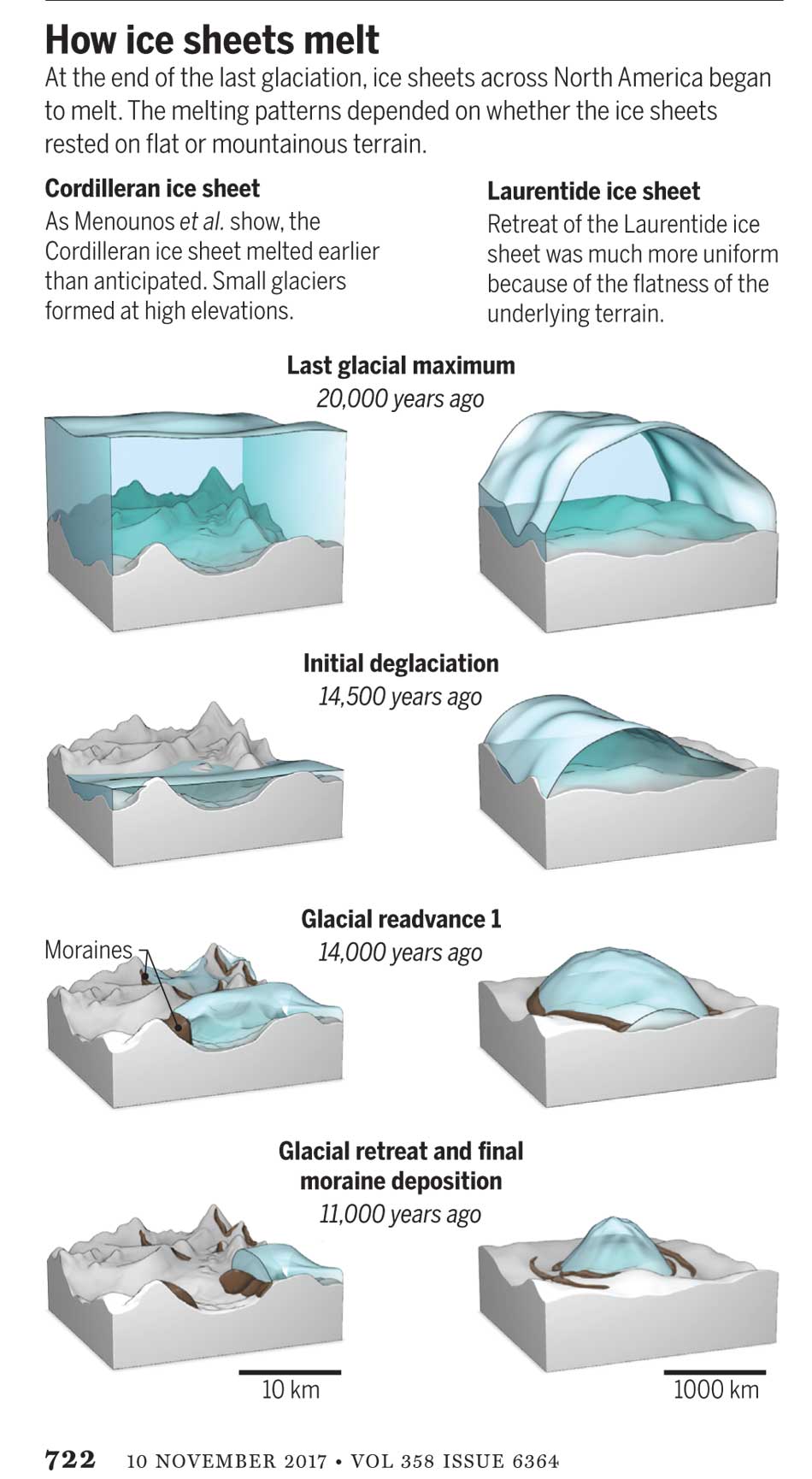
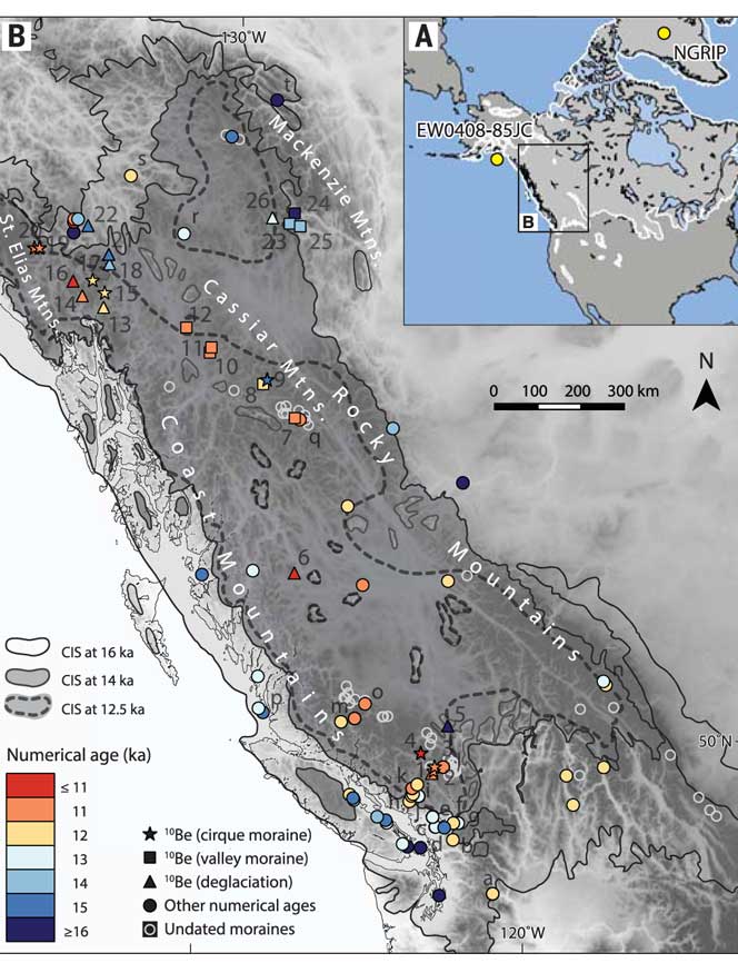
Two related scientific papers published in the past two weeks, one on the First Peoples  initial settlement of coastal  North America and the second  giving a probable new timeline of the retreat of the glaciers during the last Ice Age,  taken together  are likely confirmation of the Haisla story of how that nation first settled the Kitimat Valley.

Haisla NationAs related in Gordon Robinson’s Tales of the Kitamaat, the First Peoples living on the coast of what is now British Columbia ventured up what is now called Douglas Channel perhaps from either Bella Bella in Heiltsuk traditional territory or from Prince Rupert in Tsimshian traditional territory.

The young men on the expedition up the Kitimat Arm spotted what they thought was a huge monster kilometres ahead with a large mouth that was constantly opening and closing. The sight was so terrifying that the men fled back to their homes and dubbed the Kitimat Arm as a place of a monster.

Later a man named Hunclee-qualas accidentally killed his wife and had to flee from the vengeance of his father-in-law.   Knowing he had to find a place where no one could find him,  he ventured further up the Kitimat Arm. There he discovered that the “monster” was nothing more than seabirds, probably seagulls, perhaps feasting on a spring oolichan run.

He settled along the shore of what is now the Kitimat River and found a land of plenty, with fish, seals, game as well as berries and other natural products of the land.  Eventually he invited others to join him, which began the Haisla Nation and he became their first chief.

Let’s examine the new evidence so far.

  1. Settlement along the coastal “kelp highway” between 18,000 and 16,000 years ago, followed by a warm spell 14,500 years ago

It’s now fairly certain that the First Peoples first began to settle along the coast by following the “kelp highway” perhaps as early as 18,000 years ago and certainly by 14,000 years ago.  Haida Gwaii was ice free, except for some mountain glaciation as early as 16,500 years ago.   At about 14,500 years ago there was a warming spell which forced the glaciers to retreat, brought higher sea levels and the arctic like tundra ecosystem would have been replaced, at least for a time, by forests. There is the discovery of a Heiltsuk settlement dated to 14,000 years ago.  At that time almost all of the coast would have been free of glacial ice but there were still glaciers in the fjords, including the Kitimat Arm which would mean there could be no permanent settlement in the “inland coast” and the interior.

(Science)
  1. The cooling period from 14,000 to 11,700 years ago confines settlement to the coast

The cooling periods  (with occasional warmer times) from about 14,000 years ago to about 11,700 years ago meant that settlement would largely have been confined to the coast for about two and half millennia. The culture of the coastal First Peoples would have been well established by the time the glaciers began the final retreat.

(Remember that it is just 2,000 years from our time in 2017 back to the height of the Roman Empire under Augustus Caesar).

It is likely that the cooling periods also meant that some descendants of initial settlers likely headed south for relatively warmer climates. Rising sea levels meant that the initial settlement villages would likely have been abandoned for higher ground.

  1. A second period of rapid warming 11,700 years ago which opens up the interior fjords and valleys

At the end of what geologists call the Younger Dryas period, about 11,500 years ago, the climate warmed, the glaciers retreated further, in the case of Kitimat, first to what is now called Haisla Hill, then to Onion Flats and finally to Terrace.

  1. Large glacial sediment river deltas filled with fresh melt water from retreating ice

The most important confirmation of the story of Hunclee-qualas’s exile is the account  of the monster, the birds and the oolichan run.

The new scientific evidence, combined with earlier studies, points to the fact that the glacial melt water carried with it huge amounts of glacial sediment that created vast river deltas in coastal regions of the Northern Hemisphere.

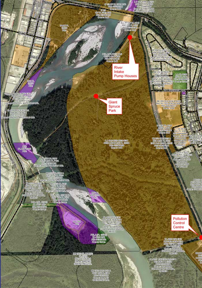
That means around 10,000 years ago,   when the Kitimat Valley was ice free and the new forest ecosystem was spreading up the valley, the Kitimat River estuary was likely to have been much larger than today.  It could have been a vast delta, which would have quickly been repopulated with fish, including salmon and oolichan. That rich delta ecosystem could have supported a much larger population of seabirds than the smaller estuary in recent recorded history.

Snow geese by the thousands in the Sacramento-San Joaquin Bay Delta/ CrunchySkies/Wikimedia Commons/Creative Commons License

The story of the monster those first travelers saw far off is highly plausible. Even today in huge, rich deltas elsewhere in the world, seeing hundreds of thousands of birds in flight over a wetland is fairly common. (For a description of what a Kitimat River delta may have been like thousands of years ago, see KCET’s story on the Sacramento-San Joaquin Bay Delta and what that delta was like 6,000 years ago)

The First Peoples had had well established communities for up to four thousand years before the Kitimat Valley’s metres of thick ice had melted away.  For the first period, while the ecosystem regenerated, for the people of the coast coming up Douglas Channel to the valley would not have been worth it, there would be little to find in terms of fish, game or forest resources.

A Snow Goose flock near the Skagit River Delta, WA./ Walter Siegmund/Wikimedia Commons
  1. The change from tundra to a rich forest environment

Eventually as the forest regenerated, the streams filled with salmon and oolichan; the bird population including gulls, geese and eagles, found a new feeding ground;  bears, deer and other animals arrived. The Kitimat region would have been an attractive place to explore and hunt. It may be the monster story did keep people away until Hunclee-qualas had to find a place to hide and discovered a new home just at a time that might be called an ecological optimum with new forests stretching back along the valley to what is now Terrace.

  1. The river delta shrinks back to the current estuary

If a vast Kitimat River delta did stretch further down the Channel than it does in 2017, it likely shrank back in the subsequent millennia.   Eventually the mass of glacial sediment that came downstream after the retreat of the ice would diminish, but not stop entirely. The estuary is still rebuilt from sediments washed downstream but that sediment doesn’t match other  rich deltas elsewhere such as the Nile in Egypt.   With that regeneration of the delta slower and smaller than in the first centuries of Haisla settlement, at the same time the land surface rebounded from the weight of the ice, perhaps creating the Kildala neighborhood.  The ocean level rose, drowning and eroding part of the old delta, creating the estuary we know today.


As the authors of the paper on the First Peoples’ settlement note, most of the archaeological evidence of early coastal settlement is now likely many metres below the surface of the ocean but deep ocean exploration may uncover  that evidence.  As the scientific team on the second paper say, they are now working on detailed studies of the glacial retreat from the coastal mountain region which may, when the studies are complete, change the timeline

While waiting for further evidence from archaeology and geology it is safe to say that the stories of the monster and later Hunclee-qualas’s discovery of the Haisla homeland are even more compelling than when Gordon Robinson wrote Tales of the Kitamaat.  We can now speculate that there was once, stretching from Haisla Hill far down the Channel, a vast, varied rich, river estuarine delta that supported hundreds of thousands of seabirds, which if they took the wing in unison, would have made those unwary travelers millennia ago, really think that there was a giant monster waiting to devour them at the head of the Kitimat Arm.


The end of the Ice Age in coastal British Columbia may indicate what will happen to shrinking ice sheets in Greenland, study indicates

If some travellers, perhaps about 12,000 years ago, had headed up what is now called Douglas Channel, around the north end of Hawkesbury Island they likely would have seen a glacial retreat driven by a warming planet, something very familiar to the television viewers of 2017, video of 21st century coastal Greenland, where massive glaciers are calving ice bergs into the ocean.

The history of rapid glacial retreat over several thousand years from the interior and coastal British Columbia at the end of the last Ice Age is now becoming a crucial indicator of what may happen to both Greenland and the Antarctica. Under the current ice sheets both Greenland and parts of Antarctica are mountain ranges similar to those here in British Columbia. According to new research published to today in Science, that may indicate what could happen as those ice sheets melt and how that will affect  volatile climate change.

The paper written by Brian Menounos of the University of Northern British Columbia and co-authors indicates that the glacial retreat  in BC was faster than previously believed, beginning about 14,000 years ago. That left some parts of  coastal and western  BC ice free, rather than beginning 12,500 years ago as previously estimated. The last Ice Age probably reached its maximum coverage about 20,000 years ago.

One of the cirque moraines at the end of a glacier studied by Brian Menounos and his team. It is in northern British Columbia just south of the Yukon border. ( Brian Menounos/Science plus Google Earth)

The decay of the ice sheet was complex, partly due to presence of mountainous terrain and also because Earth’s climate rapidly switched between cold and warm conditions during the end of the last Ice Age.
One of the factors that may have triggered a climate change back to colder conditions was a massive outflow of cold, fresh water from coastal British Columbia, which may have affected ocean currents.

What geologists call the Cordilleran ice sheet once covered all of present-day British Columbia, Alaska and the north Pacific United States. How the Cordilleran ice sheet responded to climate change was different from the Laurentide ice sheet which covered the flatter terrain (prairie and the Canadian Shield) of central North America. The Cordilleran ice sheet is about the same size as the current Greenland ice sheet.

“Our work builds upon a rich history of collaborative research that seeks to understand when and how quickly the Cordilleran ice sheet disappeared from Western Canada,” Menounos says. “Projected sea level rise in a warming climate represents one of the greatest threats to humans living in coastal regions. Our findings are consistent with previous modeling studies that show that abrupt warming can quickly melt ice sheets and cause rapid sea level rise.”

Menounos, the Canada Research Chair in Glacier Change, teamed up with 14 co-authors from Canada, the United States, Sweden, Switzerland and Norway to produce the paper titled Cordilleran Ice Sheet mass loss preceded climate reversals near the Pleistocene Termination.

One of the co-authors of the paper is John Clague, now a professor emeritus of Earth Science at Simon Fraser University who studied the glaciation patterns in the Kitimat valley and Terrace in the 1970s when he worked for the Geological Survey of Canada.

Earlier researchers, including Clague, relied on radiocarbon dating to establish when the ice sheets disappeared from the landscape. The problem is that radiocarbon dating may not work in higher alpine regions where fossil organic matter is rare (above the tree line).

Menounos and the researchers used surface exposure dating – a technique that measures the concentration of rare beryllium isotopes that accumulate in quartz-bearing rocks exposed to cosmic rays – to determine when rocks first emerged from beneath the ice. If the rocks are under an ice sheet that means they are not exposed to cosmic rays, and thus measuring the beryllium isotopes can indicate when the retreating ice exposed the rocks to the cosmic rays.

The scientists studied small “cirque moraines” found only beyond the edge of modern glaciers high in the mountains, and valley moraines.

The alpine cirque moraines could not have formed until after the Cordilleran ice sheet had retreated. Menounos and his team show that several alpine areas emerged from beneath the ice sooner than previously believed. Then once the mountain peaks emerged from the thinning ice, new, smaller glaciers grew back over the high-elevation cirques at the same time that remnants of the ice sheet “reinvigorated” in the valleys during subsequent climate reversals

Most of the work of the team was done in the interior of British Columbia, the Yukon and Northwest Territories. Menounos says that new, similar work is being done on the mountains of the coastal region which will be published when the research is complete.

At its maximum, the Cordilleran ice sheet likely extended from what is now the mainland coast across Hecate Strait to the east coast of Haida Gwaii.

Starting about 14,500 years ago, the planet entered a phase of warming, with the average temperature rising about 4 degrees Celsius over about a thousand years. The Cordilleran ice began to thin rapidly leaving what the paper calls a “labyrinth of valley glaciers,” which then allowed the alpine glaciers to re-advance.

Diagram from Science shows how the glaciers retreated at the end of the last Ice Age, with the mountainous Cordilleran ice sheet behaving differently from the central North American Laurentide ice sheet (Science)

The scientists have suggested the rapid ice loss, beginning 14,500 years ago, came relatively quickly in geological time, perhaps just 500 years. That may have then contributed to subsequent Northern Hemisphere cooling through freshwater rushing into the ocean. That melt water disrupted the overturning ocean circulation of cold and warm water. That led to a new cooling period that lasted from about 14,000 to 13,000 years ago. (Similar to the completely fictional scenario in the movie The Day After Tomorrow,  where the cooling happens in days not centuries).

That same outflow could have raised then existing sea levels by two and half to three metres, Menounos says. (The overall sea level on Earth rose about 14 metres by the end of the Ice Age)

Then the climate reversed again, first briefly warming and then in a period that saw another abrupt change back to cooler conditions which geologists call the Younger Dryas,   The Younger Dryas occurred beginning about 12, 900 years ago to about 11,700 years ago, when warming began again. The Dryas is named after a wildflower that grows in arctic tundras.

The study indicates that the First Peoples could not have settled the interior of what is now British Columbia prior to the Younger Dryas, but it is likely as was explored in a paper last week in Science that the First Peoples were able to come down the “kelp highway” on the coast by at least 14,000 years ago.

Map of British Columbia showing the extent of the glaciation during the last Ice Age and now the ice retreated. The coloured graphics are where the study was done mostly in the interior of BC and the age of the deposits. KA means kilo-years or thousand years ago. (Science)

So what happened in Douglas Channel?

So what does the new study of glacial retreat mean for the history of Douglas Channel?

John Clague studied the Douglas Channel, the Kitimat Valley and the Terrace area in the 1970s and was one of the co-authors of the current study that provides a new timeline for the retreat of the glaciers on the British Columbia coast.

He says that the timeline from his work in the 1970s with radio carbon dating of fossilized organic material is fairly consistent with the new work by Brian Menounos of the University of Northern British Columbia using the beryllium isotope technique.

The paper, Clague says, is more of a general commentary on the last stages of the decay of the Cordilleran ice sheet.

“At the time we’re taking about in the paper, there was ice in the corridor between Kitimat and Terrace.

“What we see in detail based on the work I did ages ago, is the retreat of the glacier from the Kitimat Arm back to the north towards Terrace [in the Young Dryas ]. It occasionally stabilized and the melting ice discharged a lot of sediment into that marine embayment.

Based on his original work and the new study Clague says at the time, the mountains are beginning to become ice free but there was still ice in the major valleys such as the Skeena Valley and the corridor south of Terrace towards Kitimat.

“They’re overlapping stories.” Clague says.

“The ice sheet hadn’t completely disappeared at the time Brian is focusing on,” Clague says. “His point is that a lot of the mass of the ice sheet appeared to be thinning and through marginal retreat from Haida Gwaii and some of the islands off the mainland back toward the mainland itself. So we’re trying to put a chronology on it, as to the various steps in the glacial decay.”

The work seems to indicate that the final ice sheet retreat happened in four stages around 12,000 to 11,000 years ago. “I was interested in the detailed reconstruction of the ice front tracked north from Kitimat you see a number of periods when it stabilized long enough to build up very large deltas and braided melt water plains,” Clague says.

The first moraine is Haisla Hill in Kitimat, where the glaciers discharged large amounts of sediment into what is now Douglas Channel. The second is the hill leading to what is called Onion Flats, the third is the flat area where the Terrace Kitimat Regional Airport now is and the final stage of glacial retreat created the “terraces’ around Terrace and Thornhill.

“It’s interesting that in this area there was so much sediment discharged into the sea remarkably for the time over which the ice was retreating through the area. It had to have been a major kind of discharge point of water from the ice sheet south from Terrace towards Kitimat otherwise you wouldn’t get that huge amount of sediment deposited probably over a period of a thousand years. Then it retreated again to just north of the airport and anchored there for a while and we found evidence for a final last gasp upstream around Thornhill and that kind of near Terrace.”

“At that time some of the high elevation glaciers were re-energized and readvanced, but it probably didn’t affect the overall health of the ice sheet itself It’s such a big mass of ice that it doesn’t respond quickly to such a brief cooling so what we’ve done in many places is these glaciers actually advanced up against ‘the dead ice’ an ice sheet that was lower in elevation.”

At the times the oceans rose at the end of the Ice Age, there were “sea corridors” between Kitimat and Terrace and also in the Skeena Valley. “So you can imagine there were arms of the sea extending to Terrace from two directions almost making that area which is now part of the mainland an island.” But the region likely never did become a true island, Clague says because as the ice sheets retreated,, they were also shedding large amounts of sediment that would become land area at the same time as the earth’s crust was rebounding once it was freed from the weight of the ice sheet.


West Coast “kelp highway” was the earliest route for First Peoples’ settlement of the Americas is the new scientific consensus

Most historians and archaeologists believe that the First Peoples to arrive in North America came down the West Coast on what they now call the “kelp highway.”

The review paper “The First Americans” was published this week in the prestigious journal Science.

Evidence from archaeological sites from the British Columbia coast to the southern tip of South America show that First Peoples had settled on both continents by at least 18,000 years ago, according to authors T.J. Braje at San Diego State University in San Diego, CA; T.D. Dillehay at Vanderbilt University in Nashville, TN; J.M. Erlandson at University of Oregon in Eugene, OR; R.G. Klein at Stanford University in Stanford, CA; T.C. Rick at National Museum of Natural History, Smithsonian Institution in Washington, DC.

The paper also says the DNA genomic data suggests a northeast Asian origin for Native American ancestors some time in the past 20,000 years.

(Science)

One of the key sites cited in the paper is Triquet Island in the traditional territory of the Heiltsuk Nation which has been dated to at least 14,000 years ago. Heiltsuk oral history has marked the island for generations, William Housty a member of the Heiltsuk told CBC News at the time the discovery was officially announced in April 2017, “Heiltsuk oral history talks of a strip of land in that area where the excavation took place. It was a place that never froze during the ice age and it was place where our ancestors flocked to for survival.”

The authors of the review say the new consensus on the “kelp highway” is a “dramatic intellectual turnabout” from the original idea that the first indigenous settlers followed an ice free corridor from a land bridge from Siberia down the centre of North America to form the “Clovis Culture”

The land bridge between northeast Asia and North America, commonly called Beringia, came about when sea levels fell during the last ice age. Although the original Beringia hypothesis has been disputed by some First Peoples, the paper says the Beringia hypothesis is still a factor—but much farther back in time, now about 24,000 years ago.

The paper says:

most archaeologists and other scholars now believe that the earliest Americans followed Pacific Rim shorelines from northeast Asia to Beringia and the Americas.

According to the kelp highway hypothesis, deglaciation of the outer coast of North America’s Pacific Northwest about 17,000 years ago created a possible coastal corridor rich in aquatic and terrestrial resources along the Pacific Coast, with productive kelp forest and estuary  ecosystems at sea level and no major geographic barriers

The paper says that kelp resources extended as far south as Baja California, and then—after a gap in Central America, where productive mangrove and other aquatic habitats were available—picked up again in northern Peru, where the cold, nutrient-rich waters from the Humboldt Current supported kelp forests as far south as Tierra del Fuego.

The other sites cited in the paper are

  • Huca Prieta, Peru 15,000 to 14,500 years ago
  • Paisley Caves, Oregon 14,000 years ago
  • Monte Verde, Chile 14,500 years ago
  • Page-Ladson, Florida 14,500 years ago
  • Channel Islands California 13,000 years ago
  • Quebrada Santa Julia and Quebrada Huentelauquén , Chile 13,000 years ago
  • Quebrada Tacahuay Peru 13,000 years ago
  • Quebrada Jaquay, Peru 13,000 years ago

In an earlier article in Science in August, Knut Fladmark, a professor emeritus of archaeology at Simon Fraser University who was one of the first to propose a coastal migration into the Americas back in 1979, said: “The land-sea interface is one of the richest habitats anywhere in the world,” noting that early Americans knew how to take full advantage of its abundant resources.

Testing the kelp highway hypothesis is challenging, the scientists say, because much of the archaeological evidence would have been submerged by rising seas since the end of the last “glacial maximum,” about 26,500 years ago.

The earlier that the First Peoples arrived, that means the land they originally settled is now the further offshore from the current coast  (land which is now likely also at greater depth under the current ocean). So the review says that finding the evidence means that, “enlarging already vast potential search areas on the submerged continental shelf.”

The authors say:

Although direct evidence of a maritime pre-Clovis dispersal has yet to emerge, recent discoveries confirm that late Pleistocene archaeological sites can be found underwater. Recent discoveries at the Page-Ladson site, in Florida produced 14,500-year-old butchered mastodon bones and chipped stone tools in the bottom of Florida’s Aucilla River.

The report says that “Several multidisciplinary studies are currently mapping and exploring the submerged landscapes of North America’s Pacific and Gulf of Mexico coasts, searching for submerged sites. .

In British Columbia, those studies (pdf) include the discovery by Daryl Fedje, an archaeologist at the University of Victoria and the Hakai Institute of 29 footprints on Quadra Island. A piece of wood embedded in a footprint’s fill provided the radiocarbon date of 13,200 years ago and the spear points lying and a cluster of bear bones at Gaadu Din cave on the Haida Gwaii dated to 12,700 years ago.

The review says that for much of the 20th century, most archaeologists believed humans first colonized the Americas about 13,500 years ago via the overland route that crossed Beringia and followed a long and narrow, mostly ice-free corridor to the vast plains of central North America. There,  according to the earlier theories, Clovis people and their descendants hunted large game and spread rapidly through the New World.

This was initially confirmed by twentieth-century discoveries of distinctive Clovis artifacts throughout North America. Some finds associated with mammoth or mastodon kill sites, supported this “Clovis-first” model.

The early studies decided then that “North America’s coastlines and their rich marine, estuarine, riverine, and terrestrial ecosystems were peripheral to the story of how and when the Americas were first settled by humans.”

Now the recent work along the Pacific coastlines of North and South America has revealed that these environments were settled early and continuously, providing a rich diversity of subsistence options and technological resources for New World hunter-gatherers.

A detail of the map from Science shows how off from the current coast the ancient shorelines reached (Science)

At the moment,  there is little evidence on the coast so far of the kind of  stone tools and fishtail points that had previously provided a road map that archaeologists used to trace the spread of “Clovis” Paleoindians throughout the Americas. Such a roadmap is lacking for “pre-Clovis” sites on the coast.

One proposal is that distinctive stemmed (“tanged”) chipped-stone projectile points, crescents (lunate-shaped), and leaf-shaped bifaces found in Japan, northeast Asia, western North America, and South America could be potential markers of an earlier coastal migration and  ties to Ice Age peoples in East Asia.

The problem of finding final proof of the kelp highway is that the First Peoples followed a coastal route from Asia to the Americas, so that finding evidence for their earliest settlements will require careful consideration of the effects of sea level rise and coastal landscape evolution on local and regional archaeological records.

The scientists note that around the globe, evidence for coastal occupations between  about 50,000 and 15,000 years ago are rare because of postglacial sea level rise, marine erosion, and shorelines that have migrated tens or even hundreds of kilometers from their locations at the ice age glacial maximum.

They say overcoming these obstacles requires interdisciplinary research focused on coastal areas with relatively steep offshore bathymetry, formerly glaciated areas where ancient shorelines have not shifted so dramatically, or the submerged landscapes that are one of the last frontiers for archaeology in the Americas


Council votes to create “working group” on riverbank issues, tables plan to gate access

District of Kitimat Council voted Monday five to two to create a “working group” of “concerned citizens and community groups” to consider the future of riverbank camping along the Kitimat river. The working group will consider issues such as access to the river, pollution and how to control extended camping along the river.

That vote came after council split five to two  again to defeat a motion by Councillor Mary Murphy to stop riverside camping altogether.

A proposal from District staff to put access gates at three locations, the Giant Spruce Road, the Sewage Plant and the Pump House was tabled for the time being. However, the councilors and staff marked the pump house gate as a priority for study by the engineering staff due to concerns that “the risk of fuel, oil and other contaminants (i.e. Illegal dumping ) occurring. This is the source water area for the city’s water supply, reducing access reduces contamination risks.” Staff said that unlike other portions of the riverbank, the District does “have authority under drinking water protection act to protect this area.”

Council also voted to close Hirsh Creek park immediately because the roads at the camping area were washed out by the flood last week.

Councillors noted that many people still go to Hirsch Creek after the gates are closed at the end of the season to walk dogs or hike. This results in a parking jam at the front of the gate and on busy times, cars park on Highway 37 which could endanger pedestrians.

District staff will study moving the park gate down further to a point that the road narrows near the first campsite to allow safe access for dog walkers and hikers.

The main problem facing the District of Kitimat is that most popular sites along the riverbank for campers are on provincially owned Crown land. In 2014, the former BC Liberal government passed a regulation that says people can camp on Crown land for up to 14 days. As some councillors pointed out this restriction regularly abused by some campers who stay on the riverbank for weeks, some apparently camping from Victoria Day to Labour Day.

A detail from the DoK map of who owns the riverbank shows that many of the popular camping sports along the Kitimat River are on provincial Crown land (dark green) while the municipality controls the land away from the riverbank including the access roads (brown). (District of Kitimat)

During the debate it was pointed out that often those camp on the riverbank like to “claim” a camping/fishing spot and try to prevent others from using it. “I know of a couple of fistfights,” Murphy told Council.

As Councillor Rob Goffinet pointed out, whether or not the District could place gates on municipal land to stop access to provincial Crown land would require a legal opinion.

Murphy told Council that she had received emails, blaming Kitimat for “almost drowning” some of the campers. She said that her views may be unpopular among some residents, but added, “I don’t care if I’m unpopular, I want to keep people safe.”

Councillor Larry Walker, who pointed out that he likes of fish along the river, who supported Murphy’s motion told his colleagues to get their act together and “do something about the riverbank.” He later proposed that if council does nothing, perhaps Kitimat should hold a referendum on the future use of the river bank.

The majority on Council were more cautious, while acknowledging problems. They pointed out that the many of the campers both on the east bank and on the west bank at Radley Park patronize local businesses during the summer months.

While there was wide discussion on social media before the council meeting, only three people showed up to give their opinions, mostly concerned about permitting access to the river for people with mobility issues or small children.

There were many comments and questions about how other areas police provincial Crown Land, with some saying that some places restrict access to only a couple of days. However, no one either on Council or staff had any idea of what exactly other locations are doing, if anything.

There were no details of how the working group would operate and who would participate. During the debate it was pointed out that as well as the province, participants would have to include Rio Tinto, LNG Canada and DFO. As well, Council did not set a deadline for the working group to report back.

As Murphy pointed out back in 2014, Fisheries and Oceans refused to attend a Council meeting or make a public presentations on its views of the river bank situation. (DFO snubs District of Kitimat Council for a second time )  while offering to meet with staff “they will continue to meet at an operational level to provide information on DFO’s regulatory role.”  That, of course came during the Stephen Harper administration which severely restricted any public participation by the civil service on environmental issues. Whether the Justin Trudeau government has changed that policy remains to be seen.

The campsite road at Hirsch Creek park was washed out in the flood. (District of Kitimat)

Was the rain storm an anomoly?

During the debate, Mayor Phil Germuth, pointed to the sudden onslaught of rain during Sunday and Monday September 10 and 11 and called it “an anomaly” which means that Kitimat should not overreact to the storm.

Environment Canada chart of the spike in the Kitimat River levels, as presented to District Council. (Environment Canada)

However, as The New York Times pointed out after Hurricane Harvey hit Texas, scientists have been warning for years that

Climate science has repeatedly shown that global warming is increasing the odds of extreme precipitation and storm surge flooding. Refusing to acknowledge this impairs our ability to prepare for future extreme weather and endangers American lives and property.

And another opinion article in the Times during Hurricane Harvey noted:

Scientists can now even evaluate how much climate change has increased the odds of individual extreme events, including rainfall and flooding.

As the 2015 American Meteorological Society report quoted by The Times indicates, those  unpredictable and extreme events don’t just include floods but the widespread forest fires in Alaska in 2014 and we all know how bad the fire season has been in British Columbia this year.

Report on extreme weather events

As Noah Diffenbaugh  of Standford University pointed out in The Times

Being smart about managing exposure and vulnerability is critical to reducing risks. But doing so requires acknowledging that global warming is happening, that humans are the primary cause and that the odds of catastrophes like Hurricane Harvey are increasing.

District clarifies who owns the riverbank, will debate shutting off vehicular access at Monday’s meeting

The District of Kitimat has issued a map clarifying just who owns the banks of the Kitimat River, a subject that has been debated for years, as campers have come and gone as they please.

The map issued by the District staff shows that the District of Kitimat has jurisdiction over much of the land on the east side of the river while Rio Tinto owns much of the western bank–but also does own some of the eastern bank in the lower levels.

District staff are recommending that gates be installed in three areas along the eastern bank on municipally owned land, at the Giant Spruce Road, at the Pump House and at the Sewage plant. That could cut off vehicular traffic while still allowing access for pedestrians and those who wish to fish on the river bank by getting access on foot.

The proposed locations of the gates are marked in red on the map.


Map showing who owns the riverbank lands with the proposed gates marked by red dots. (District of Kitimat)

You’ll find a larger version of the map, and staffs’ recommendations to District Council in the report.

DistrictofKitimatriverbankreport (pdf)


RCMP, Fire warn of continuing hazards after “unique” Kitimat River flood

Both the RCMP and Kitimat Fire and Rescue are warning residents to stay away from the Kitimat River until the high water recedes. As well there are likely new hazards from a possible change in the river’s path due to the high water and as well as from debris in Douglas Channel.

Both detachment commander Staff Sergeant James McLaren and Fire Chief Trent Bossance made a special presentation to District of Kitimat Council Monday night to bring council up to date on the events that began early Monday morning.

The riverbanks are still hazardous, McLaren told Council and he urged that everyone stay away for at least the next two days. Anyone going out to fish in the Kitimat Arm of Douglas Channel, may also face hazards from snags, logs and debris such as floating propane cans. Bossance told Council in reply to a question from Councillor Larry Walker.

As well, Bossance told Council that the sudden deluge that began on Sunday afternoon is “not typical at all like the regular October flooding” that may be seen on the river.

Environment Canada chart of the spike in the Kitimat River levels, as presented to District Council. (Environment Canada)

Bossance warned that due to the volume and speed of the water it is likely that some parts of the river bed and river course have changed, and that the sandbars and snag areas that people may be familiar with may have shifted.

The effects of the flood are being monitored by RCMP, Fire and Rescue, Conservation officers, Fisheries and Oceans and provincial environmental officials.

Bossance said that the consensus of those officials is that the flood situation is unique in the history of Kitimat. Environment Canada issued a severe rainfall warning at noon on Sunday.

Bossance told Council  that people who were able to leave the riverbank said that they were able to walk out at about one a.m.  By 2:30 am, the river had risen so rapidly—about four metres—that by then people were trapped and calling 911 for help. McLaren said the RCMP immediately asked for the assistance of Kitimat Search and Rescue, who then requested assistance from Terrace Swift Water Rescue. Those units rescued twelve people from the riverbank.

A helicopter was called in and rescued two people.  The helicopter then made a sweep of the river bank but found no one else in danger.

McLaren told Council that as of 7 pm Monday no one had been reported missing or overdue.

The number of flooded vehicles or vehicles swept into the river is not certain, McLaren said,  but the number is estimated between twelve and fourteen ranging from large recreational vehicles to cars.   A preliminary assessment by ICBC indicates that the damage or loss of  vehicles will be covered but that will have to be confirmed by the vehicle owners.

Bossance said that high tide was not that much of a factor since it occurred at 5:30 am. Most of the high water was runoff from the upper Kitimat River.

Of the fourteen people rescued two were Kitimat residents, the rest from out of town.  Emergency social services has assisted those needed to find housing.

The RCMP will continue increased patrols in the river area until the danger has passed.

Campers rescued from Kitimat River bank after heavy rain storm

Heavy rain and strong winds combined with high tide overnight Sunday, September 11 flooded out fishers and campers along the Kitimat River.

The RCMP say  twelve people were rescued via boat and two by helicopter, mostly along the Big Spruce bank.  The RCMP say all are currently accounted for, although police say they will have to check the riverbanks once the water levels drop in about 48 hours.

Another view of the RV that was swept into the river. (Robin Rowland/Northwest Coast Energy News)

Kitimat Search and Rescue, Kitimat Fire and Rescue, RCMP and Terrace Swift Water Rescue participated in the operation.

The RCMP is asking the public to contact them about concerns about people who may be overdue or possibly missing at 205-632-7111.

A large recreational vehicle is surrounded by swift water on the Kitimat River, Sept. 11, 2017. (Robin Rowland/Northwest Coast Energy News)

It is estimated that the river quickly rose about four metres. The rising water made it impossible for some people to retreat to the Dyke Road.

The first calls for help came to RCMP about 2 am Monday, with more around 3:30 am and the rescue began at first light about five hours later.

Environment Canada issued a heavy rainfall warning at noon on Sunday, calling for at least 66 millimetres of rain. It appears that some of the campers were either not aware of the warning or thought they could ride out the storm.

Perhaps as many as a dozen recreational vehicles were flooded or swept into the river, along with a pickup truck and a small car.

Some of those who were evacuated from the riverbanks were sheltered at the Riverlodge Recreation Centre.

Environmental and fisheries officials will be checking for any pollution in the river once conditions are safe.

The District of Kitimat is warning people to stay away from the riverbanks since the swift water can quickly destablize the soil along the river. The District has closed Radley Park and Hirsh Creek parks for the remainder of the season. The Dyke Road and Big Spruce roads are also closed.

Petronas “will not proceed” with Prince Rupert LNG project

Petronas Tuesday issued the following news release:

PETRONAS AND PARTNERS WILL NOT PROCEED WITH PACIFIC NORTHWEST LNG PROJECT

Malaysia’s energy company remains committed to developing its gas assets in Canada

KUALA LUMPUR, 26 July 2017 – PETRONAS and its partners have decided not to proceed with the Pacific NorthWest LNG project at Port Edward in British Columbia, Canada.

The decision was made after a careful and total review of the project amid changes in market conditions.

PETRONAS’ Executive Vice President & Chief Executive Officer Upstream, Anuar Taib said, “We are disappointed that the extremely challenging environment brought about by the prolonged depressed prices and shifts in the energy industry have led us to this decision.”

“We, along with our North Montney Joint Venture partners, remain committed to developing our significant natural gas assets in Canada and will continue to explore all options as part of our long-term investment strategy moving forward,” added Anuar.

PETRONAS’ commitment in Canada continues through Progress Energy Canada Ltd and its world-class inventory of natural gas resources where the subsidiary plays a key role in supporting PETRONAS’ growth strategy in North America.

PETRONAS and the project’s partners are thankful for the support received from everyone involved, especially the area First Nations, the District of Port Edward, the City of Prince Rupert and their communities for their invaluable involvement and efforts in the project.


Missing Indigenous Women inquiry staff in Smithers on July 17 for preliminary meetings

The staff of the National Inquiry into Missing and Murdered Indigenous Women and Girls will be in Smithers beginning on Monday, July 17 to consult with First Nations and other members of the Highway 16 communities.

The full Truth Gathering Process  community hearings will begin in Smithers on September 25 for one week.

Skeena Bulkley Valley MP Nathan Cullen commented, “The announcement that the National Inquiry into Missing and Murdered Indigenous Women and Girls (MMIWG) will soon stop in Smithers is good news for families along the Highway of Tears who have lost loved ones to violence.

“It is absolutely essential for inquiry commissioners to travel to Northwest BC to hear directly from families along the Highway of Tears, Cullen said.  “Reading statements and stories online or by letter does not have the same impact nor impart the very real dangers that First Nations women and girls face when travelling between remote, rural Highway 16 communities.”

In a news release July 6, (pdf)  Chief Commissioner Marion Buller announced  that “the National Inquiry is moving forward on the advice and guidance heard from families, survivors and grassroots organizations about how best to hear their stories of violence against Indigenous women and girls, including LGBTQ2S people. This next step is rooted in the knowledge gained from meetings that took place across Canada, with the latest being from the hearings in Whitehorse in May/June 2017.”

Complete schedule of MMIWG hearings (pdf)

At Smithers and other locations the preliminary meetings will allow staff  to participate in community visits to lay the groundwork for the hearings as part of the National Inquiry’s Truth Gathering Process.

Community visits allow:

  • the health team and legal counsel to meet with family members and survivors to prepare them for the community
    hearings;
  • the community relations team to meet with local organizations, Indigenous groups and women’s groups to learn more
    about local issues regarding violence against Indigenous women and girls, including LGBTQ2S people
  • the logistics team to conduct site visits for the upcoming hearings;
  • National Inquiry staff to seek the advice and guidance from Elders and knowledge keepers so that when we return to the
    community hearings we may respect and include local protocols and ceremonies.

For individuals and families who wish to participate in the hearings, the inquiry has set up a six step process that is outlined on their website.
How to participate in the MMIWG hearings (pdf)
Cullen says he hopes last Thursday’s announcement of the second round of community visits and hearings by commissioners opens the door to a more productive and collaborative process.

“There have been many challenges to getting the work of the inquiry off the ground, directly including families in the work, and developing a sufficiently broad mandate to allow real understanding of the deeper issues of violence against Indigenous women and girls,” he said.

“The inquiry’s recognition of the need to hold hearings in Smithers is very positive.

Did Neanderthals honour the raven?

A new discovery by archaeologists in Crimea is providing evidence that ancient Neanderthals had a high cognitive and artistic ability. That evidence is the carved leg bone of a raven also raising the question (not actually included in the archaeologist’s paper) does the relationship between human and raven go back to a period between 38,000 and 43,000 years ago?

For more than a century, archaeologists have debated the question of just how smart the Neanderthals, the species that preceded what archaeologists now call “Modern Humans” into Europe and west Asia and there is increasing evidence of Neanderthal intelligence.

The raven bone fragment  which has been dated between 38,000 and 43,000 years ago, was found at the Zaskalnaya VI site in Crimea. It is described in to a study by Ana Majkic at the Universite de Bordeaux and colleagues, A decorated raven bone from the Zaskalnaya VI (Kolosovskaya) Neanderthal site, Crimea. published in the open access journal, PLOS ONE on March 29, 2017. 

The site in the Crimea was once a campsite in a river gully.

Location of Neanderthal campsite in a river gully in what is now Crimea. (PLOS1)

The radius bone fragment has seven notches. Microscopic analysis of the notches indicate that they were produced by the to-and-fro movement of a lithic (stone) cutting edge and that two notches were added to fill in the gap left between previously cut notches, probably to increase the visual consistency of the pattern.

The study worked to duplicate and test the work of the Neanderthal crafts person by examining sets of notches cut by nine modern experimenters on the leg bones domestic turkeys shows that the variations recorded on the Zaskalnaya set are comparable to experimental sets made with the aim of producing similar, parallel, equidistant notches.

A raven on the dock at Masset, Haida Gwaii, June 2016. (Robin Rowland/Northwest Coast Energy News)

The object represents the first instance of a bird bone from a Neanderthal site bearing modifications that cannot be explained as the result of butchery activities.

That means the argument that bone notches are symbolic argument can be built on direct evidence.

The respect that British Columbia and Alaska First Nations have for the raven is found in countless legends and stories. Other cultures have honoured the raven including the Celtics who believed the raven was symbol of war, the Vikings and Greeks where the raven was a messenger of the gods, to name just a few.

The discovery of the raven bone in a Neanderthal cave may mean that the relationship with the raven is much more ancient than previously believed.

The paper says evidence of burials, collection of rare items, production of engraved and perforated objects, personal ornaments, pigment use, and the extraction of bird  feathers and claws support the notion that Neanderthals engaged in symbolical behavior, independently from the influence of anatomically modern humans.

Neanderthal burials of infants, children, and adults have been reported at several sites throughout Europe and the Near East, some of which are associated with grave goods. Pigment use among Neanderthals dates back as far as between 200,000 to 250,000 years ago. Pigment use became a more widespread practice about 60,000 years ago.

A string of new discoveries have shown that Neanderthals regularly exploited birds. The activities conducted by Neanderthals that may reflect their involvement in symbolic activities have been found in Italy, in caves in Gibraltar, nine sites in France and one Croatia.

Those discoveries indicate that cut-marks and scraping marks on upper limb bones mean that feathers were purposely detached from the wings of seven different bird species, including the common raven and the red-billed chough (a red beaked and red legged crow that is sacred in Wales and Cornwall). Others were the white-tailed and golden eagles, two species of vulture, and an unidentified raptor.

The study says that removal of feathers and claws is interpreted as proof that these objects were used as personal ornaments by Neanderthalsm the study says.  Feathers and claws do not survive archaeologically. So far, no clear modifications for suspending or threading the claws were found so far on bird talons, so up until now this was considered circumstantial evidence.

On the left is the notched raven bone from Zaskalnaya VI Neanderthal site, Crimea. center: experimental notching of a turkey bone; right: sequences of experimentally made notches compared to those from Zaskalnaya VI. (Francesco d’Errico)

As for the raven bone found in Crimea, the scientists say it is more probable that the Neanderthal took the decision of adding notches two and six, after completing the first set and realizing that its production left two gaps.

Two reasons may account for this action. The craftsman may have considered that, if made for functional reasons, i.e. to facilitate the grip of the object, the notches of the first set were not frequent and numerous enough to fulfill that function. Alternatively, he/she may have considered, irrespective of the possible functional reason behind the production of the
notches, that it was important to add two notches in order to create a visually more regular and consistent pattern.

The archaeologists conclude the artistic hypothesis more probable because adding the two very small and superficial notches added virtually nothing to the gripping power of the object`s surface.

The results of the study pinpoint that a clear effort has been put to reach the goal of producing not just random but instead equidistant notches, that would have been perceived as regularly spaced. This implies that the resulting pattern could have conveyed an information, not directly linked to the object function, communicating to the user, and likely other members of the Neanderthal group. In this respect the sequential notches on the ZSK raven bone represent the first case of bird bone use by Neanderthal for which a symbolic function can be argued on direct rather than circumstantial evidence.