Ottawa’s Northern Gateway consultation with First Nations limited to three simple questions and 45 days: documents

The federal government’s main consultation with First Nations on the Northern Gateway Joint Review Panel report is limited to just three simple questions that had to be answered within 45 days, according to documents seen by Northwest Coast Energy News.
Joint Review Panel cover
Cover of Volume 1 of the Joint Review Panel ruling on Northern Gateway

That despite the fact that the first volume of the JRP report “Connections” is 76 pages and the second volume “Considerations” is 418 pages including the 209 recommendations and appendices and came after two years of hearings and tens of thousands of pages of evidence.

On Dec. 6 and again on Dec. 16, 2013, just prior to the release of the Joint Review Panel report, Brett Maracle, Crown Consultation Coordinator at the Canadian Environmental Assessment Agency for the Northern Gateway project wrote to the First Nations potentially affected by Northern Gateway, saying their response had to be filed within 45 days of the release of the JRP. Since the report was released on December 19, 2013, that made the initial deadline January 31, 2014.

The letter also told the First Nations that if they wanted their positions included in the “Crown Consultation Report” that would be part of the package on Northern Gateway presented to the federal cabinet, that position had to be limited to just two to three pages “given the number of groups involved” with a final deadline of April 16, 2014.

Maracle’s letters used the term Phase IV to define the post JRP consultations, implying there were three earlier stages of consultation, something many First Nations have disputed, especially since the Harper government had earlier maintained that the JRP itself was the constitutionally mandated consultation.

The cabinet has until June 19, 2014, 180 days after the release of the report to approve the issuing of the federal permits for the Northern Gateway project. Consultation with First Nations on projects such as the Northern Gateway is required by the Constitution and has been upheld by the Supreme Court of Canada.

The three questions outlined in the letter were:

  • Does the Report appropriately character the concerns you raised during the JRP process?
  • Do the recommendations and conditions in the Panel Report address some/all of your concerns?
  • Are there any “outstanding” concerns that are not addressed in the Panel Report? If so, do you have recommendations (i.e proposed accommodation measures) how to address them?

Consultation on implementation

The third question appears to confirm what most political observers have said, approval of the Northern Gateway by the Harper cabinet is a a forgone conclusion, since Maracle speaks of “accommodation measures.” When the JRP approved the Northern Gateway project, the panel said that Enbridge’s proposed “mitigation” measures in case of a spill were adequate, something environmental groups and First Nations are now disputing in court.

It appears from the correspondence seen by Northwest Coast Energy News, that the federal government will only consider further specific consultations with First Nations after the approval of the Northern Gateway and only then on the implementation and construction process, rather than consulting on the project as a whole.

The Haisla have filed a document in response to the JRP that notes that

The Haisla Nation needs to understand Canada’s views of the role that future federal decisions might play for the proposed project. In its December 12, 2013 to Mr. Maracle, the Haisla Nation asked the federal government to provide a comprehensive list of the regulatory permits which would be issued the the federal government decision-makers in Haisla Nation Territory in the event the proposed project is approved and describe the consultation process that would occur prior to decisions being on those regulatory permits, within 45 days of the issuance of the JRP Report.

Mr. Maracle’s January 29, 2014 [reply] suggests that the only future federal decisions on the proposed project which may entail consultation are specific watercourse crossing and fish habitat destruction permits issued by Fisheries and Oceans Canada.

Whole-of-government

One of the problems reaching back to long before the Joint Review Panel hearings began is that the Harper government policy was what they called a “whole-of-government” approach in its consultations with First Nations, saying: “The Crown is open to discussing how consultation with the framework provided will be carried out.”

In their repose, the Haisla say the federal government never defined how the “whole-of-government” approach to First Nations was going to work and noted:

What Canada should have realized is that it has a very real obligation to consult with the Haisla Nation at the deepest end of the consultation spectrum that cannot be pigeon-holed into a one size fits all approach.

Further, the term whole-of-government is misleading, as this approach actually prohibits the majority of government from engaging in consultation.

The Haisla then say: “Documents we have obtained under an Access to Information Request clearly indicate individual departments were asked not to communicate directly with the Haisla Nation.”

The response goes on to say:

Further questions at federal government witnesses during the JRP process confirmed that federal departments had not met with the Haisla Nation since the commencement of the JRP process. While these witnesses were reluctant to confirm that they had been prohibited from meeting with us, they repeatedly referred to the “whole-of-government” approach to consultation as their reason for not meeting.

Canada’s “whole-of-government” approach clearly limited engagement to a strict process with no opportunity for real engagement.

Earliest stages

The Haisla are telling the Harper government:

It is clear that the Haisla Nation that we are the very earliest stages of consultation with Canada about the proposed project….It is clear to the Haisla Nation that the 45-day period within which Canada has unilaterally determined face-to-face meetings with all the Aboriginal groups potentially affected by the proposed project will occur is not an adequate amount of time to complete a meaningful consultation process.


Related

Haisla ask cabinet to postpone Northern Gateway decision to allow for adequate consultation with First Nations

Haisla consultation reply outlines flaws in Northern Gateway Joint Review report

Haisla response lists evidence rejected by Northern Gateway Joint Review

Haisla consultation reply outlines flaws in Northern Gateway Joint Review report

Haisla NationThe Haisla Nation response to the federal government’s request for consultation on the Joint Review Panel report on the Northern Gateway lists what the First Nation sees as flaws in the panel’s assessment of the project. (The Haisla filed their first list of flaws in the JRP in a court challenge).

In the response, seen by Northwest Coast Energy News, the Haisla are objecting to both the government’s and the JRP’s attitude toward the idea of consultation as well as some of the specific findings by the panel. The Haisla also fault the JRP process for refusing to take into consideration reports and studies that were released after the evidentiary deadlines.

Overall, the Haisla say

 The JRP report is written in a way that prevents an assessment of how or whether the JRP considered Haisla Nation concerns and of how whether the JRP purports to address the Haisla Nation’s concerns. Further the JRP Report is lacking n some of the fundamental justification required to understand how arrived at its recommendations.

So what are the Haisla concerns?

In the document filed with the Canadian Environmental Assessment Agency, the Haisla say:

 The proposed project carries with it an inordinate amount of risk to Haisla Nation Territory. The Haisla Nation is being asked to play host to this proposed project, despite the risk the proposed project poses to the land waters and resources relied on by the Haisla Nation for sustenance and cultural heritage. The risk includes a huge risk to Haisla Nation aboriginal rights to trap, hunt and fish, to gather seafood and gather plant materials. It could result in significant damage to the Haisla Nation cultural heritage—its traditional way of life…..

The terminal site is one of the few areas suitable for terminal development in our territory. It is also home to over 800 Haisla Nation Culturally Modified Trees (CMTs). Northern Gateway proposes to irrevocably alter the land, the use of the land and access to this land for the duration of the proposed project, which is anticipated to be at least 80 years. This irrevocable alteration includes the felling of our CMTS….

By seeking to use Haisla Nation aboriginal title land for the proposed project, Northern Gateway will be effectively expropriating the economic value of this land. Northern Gateway is proposing to use Haisla Nation aboriginal title land for a project with no benefit to the Haisla Nation and which is fundamentally at odds with Haisla Nation stewardship principles.


Obstructed clear understanding 

The Haisla say that “Canada has failed to adhere is own framework” for the JRP because in the Aboriginal Consultation Framework says “Federal departments will be active participants in the JRP process to ensure the environmental assessment and consultation record, is as accurate and complete as possible.”

The Haisla say “Canada provided limited written evidence to the JRP” and goes on to say that the “federal governments not only failed to provide relevant information but also obstructed a clear understanding of project impacts.”

Among the evidence relevant to Northern Gateway that the federal government was “unable or unwilling to provide” includes:

  •  Natural Resources had expertise on acid rock damage and metal leaching but did not include evidence on that in their evidence
  •  Fisheries and Oceans did not have a mandate to conduct an assessment of the potential toxicological effects of an oil spill.
  •  Environment Canada did not review or provide information on the spills from pipelines.
  • The federal government witnesses were unable to answer questions about the toxicity of dispersant.
  • Environment Canada was asked if it had studies of the subsurface currents and the movement of submerged oil. Environment Canada told the JRP did not measure hydrodynamic data but relies on DFO. DFO cold not provide any witnesses to the JRP with expertise on subsurface currents.


In the formal response on the JRP report, Haisla also say:

  •  The JRP has concluded that the risk of a large spill form the pipeline in the Kitimat River Valley is not likely, despite very significant information gaps relating to geohazards, leak detection and spill response.
  •  The JRP has concluded that a large spill would result in significant adverse environmental effects. However, the JRP appears to base a finding that these effects are unlikely to occur on an unreasonable assumptions about how widespread the effects could be or how long they would last. The JRP has not considered the extent to which a localized effect could impact Haisla Nation.
  •  The JRP relies on the concept of “natural recovery” as mitigation of significant adverse effects. The Haisla Nation asked the JRP to compel information from Northern Gateway about the applicability of its evidence to species found in Haisla National Territory. The JRP, however, refused to compel this evidence from Northern Gateway.
  •  The JRP has accepted at face value that Northern Gateway would shut down its pipeline within 13 minutes in the event of a rupture and has failed to consider the effects of a large spill that is not detected with this timeframe through the control centre (or was in the case of Kalamazoo, is detected by the control centre but is systematically mischaracterized and ignored).

As part of the consultation process the Haisla want 22 changes to the JRP report, changes which echo the Haisla Final Written Argument that was filed at the end of the hearings.

It says:

 The Panel should find that potential impacts to asserted Haisla Nation aboriginal rights and title from the proposed project are such that project cannot be found to be in the public interest in the absence of meaningful consultation… The current status of engagement and the federal government imposition of a 6-month time limit to complete consultation raise serious concerns that meaningful consultation will not be possible. Therefore the proposed project is not in the public interest.

Among the others are:

  • The JRP should have determined the significant of adverse effects to rare ecological communities that cannot mitigated.
  • The JRP should have provided more information to allow a reasonable assessment of the risk of a spill from the pipelines.
  • The JRP would have considered all factors to contribute to the risk of a spill.
  • The JRP should have found that Northern Gateway’s assessment of the toxicity of an oil spill because it did not consider the full range of products to be shipped nor did it consider the potential pathways of the effect of a toxic spill, whether from a pipeline, at the marine terminal or in the case of a tanker spill
  • The evidence had not demonstrated that Northern Gateway’s spill response would be able to mitigate the effects of a spill either at the pipeline, at the Kitimat marine terminal or from a tanker spill.
  • The JRP did not consider the impact of the Kitimat Marine Terminal on their cultural and archaeological heritage, including culturally modified trees.

Related

Ottawa’s Northern Gateway consultation with First Nations limited to three simple questions and 45 days: documents

Haisla ask cabinet to postpone Northern Gateway decision to allow for adequate consultation with First Nations

Haisla response lists evidence rejected by Northern Gateway Joint Review
Haisla response lists evidence rejected by Northern Gateway Joint Review
Members of the Joint Review panel make notes at Kitamaat Village (Robin Rowland)
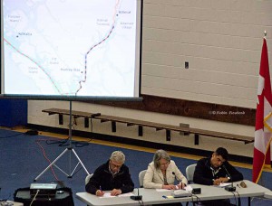
Members of the Northern Gateway Joint Review Panel, left to right, Kenneth Bateman, chair Sheila Leggett and Hans Matthews make notes at the June 25, 2012 hearings at the Haisla Recreation Centre, Kitamaat Village. A map of Douglas Channel can be seen behind the panel. (Robin Rowland/Northwest Coast Energy News)

The Haisla Nation in their response to the Crown on the Northern Gateway Joint Review Panel details four studies, three Canadian and one American that were released after the Joint Review evidentiary deadline had passed, evidence that the Haisla say should be considered in any consideration of the Northern Gateway pipeline, terminal and tanker project. (The American report from the National Oceanic And Atmospheric Administration was released after the JRP final report)
JRP chair Sheila Leggett’s constant citing of rules of procedure and her stubborn refusal to consider new evidence and studies in a dynamic situation that was changing rapidly was one of the reasons that many people in the northwest said the JRP had lost credibility.

The Haisla say: “It is incumbent upon Canada to consider and discuss the information in these reports as part of a meaningful consultation process…” and then lists “key findings” that have potential impacts on aboriginal rights and title:

The West Coast Spill response for the government of British Columbia which found:

  • Most oil spilled into the marine environment cannot be cleaned up
  • There is a disconnect between planning and actual repose capability
  • Canada’s spill response is “far from world class.”

The Transport Canada Ship Oil Spill Preparedness and Response study:

  • Douglas Channel will go from low risk to high risk for pills if the project goes ahead
  • The study recommends preparation for a “true worst case discharge” rather than “the credible worst case discharge” as proposed by Northern Gateway
  • Canada needed a much more rigorous regulatory regime covering tankers.

The joint federal government technical report on the properties of bitumen from the Canadian Oil Sands:

  • There are uncertainties on how diluted bitumen would behave in a marine environment.
  • Northern Gateway did not provide adequate information about sediment levels to allow for proper study of interaction with diluted bitumen
  • Dispersant may not be effective.
  • Weathered diluted bitumen would “reach densities at which it will sink freshwater without mechanical or physical assistance.”

The US National Oceanic And Atmospheric Administration report on Transporting Alberta Oil sands:

  • Diluted bitumen has “significant differences from conventional crudes.’ (The JRP used conventional crude as a benchmark in its findings)
  • The physical properties of diluted bitumen “fluctuate based on a number of factors.
  • Pipeline operators may not have detailed information related to products in the pipeline at the time of a spill
  • There is a lack of experimental data on the weathering behaviour of oil sands product which limits the ability of spill response organizations “to understand and predict the behaviour and fate of oil sands products in freshwater, estuarine and saltwater environments.”

 
Related

Ottawa’s Northern Gateway consultation with First Nations limited to three simple questions and 45 days: documents

Haisla ask cabinet to postpone Northern Gateway decision to allow for adequate consultation with First Nations

Haisla consultation reply outlines flaws in Northern Gateway Joint Review report


Two JRP conditions are already outdated, Cullen says

Skeena Bulkley Valley MP Nathan Cullen says at least two of the Northern Gateway Joint Review Panel’s 209 conditions may already be outdated.

In a news release January 15, 2013, Cullen said, “The requirement of $950 million in spill insurance was recently called into question as reports surfaced of cleanup costs at the sites of Enbridge’s 2010 Michigan spill surpassing $1.035 billion.”

The $1.035 billion figure was contained in Enbridge’s American arm, Enbridge Energy Partners, latest filing for the third quarter over 2013 with the US Securities and Exchange Commission.
Cullen went to say that, “The JRP’s order for Enbridge to carry out new research on the behaviour of diluted in bitumen in a marine environment has been questioned following the publication of an Environment Canada study confirming that diluted bitumen will sink in saltwater in high waves and where sediment is present.”

Cullen is referring to a study by Environment Canada Emergencies Science and Technology,Fisheries and Oceans Canada Centre for Offshore Oil, Gas and Energy Research and Natural Resoures Canada on bitumen that was completed in November and released this week.

The study found

. Like conventional crude oil, both diluted bitumen products floated on saltwater (free of sediment), even after evaporation and exposure to light and mixing with water;
. When fine sediments were suspended in the saltwater, high-energy wave action mixed the sediments with the diluted bitumen, causing the mixture to sink or be dispersed as floating tarballs;
(The use of the term “tarball” in this report follows convention in the literature and refers to the consistency of floating, heavily-weathered oil. It does not describe the chemical composition of the product.)
. Under conditions simulating breaking waves, where chemical dispersants have proven effective with conventional crude oils, a commercial chemical dispersant (Corexit 9500) had quite limited effectiveness in dispersing dilbit;
. Application of fine sediments to floating diluted bitumen was not effective in helping to disperse the products;
. The two diluted bitumen products display some of the same behaviours as conventional petroleum products (i.e. fuel oils and conventional crude oils), but also significant differences, notably for the rate and extent of evaporation.

Read the report:Properties, Composition and Marine Spill Behaviour, Fate and Transport of Two Diluted Bitumen Products from the Canadian Oil Sands (pdf)
The Joint Review Panel found that dilbit was “ no more likely to sink to the bottom than other
heavier oils”

The Panel acknowledges the variety of opinions from experts regarding the behavior and fate of oil spilled in aquatic environments. These experts generally agreed that the ultimate behavior and fate of the oil would depend on a number of factors, including the volume of oil spilled, the physical and chemical characteristics of the product, and the environmental conditions at the time.

The Panel finds that likely oil behaviour and potential response options can be predicted from knowledge of the type of oil spilled and its physical and chemical characteristics. Details of oil behaviour and response options cannot be specified until the actual circumstances of a spill are known.

The Panel is of the view that, if placed along a spectrum of: tendency to submerge; persistence; and recovery difficulty, dilbit would be on the higher end of the spectrum, similar to other heavy oil products.

The Panel accepts evidence from previous spills showing that, in response to circumstances at the time, the behaviour of heavier oils, including conventional oils and synthetic crudes, can be dynamic. Some oil floats, some sinks, and some is neutrally buoyant and subject to submergence and overwashing.

Although the project would transport different types of oil, the majority of the evidence presented during the hearing process focussed on whether dilbit is likely to sink when spilled in an aquatic environment. In light of this, the Panel has chosen to focus its views on dilbit. The Panel heard that the fate and behaviour of dilbit has not been studied as much as that of other oils.

Although there is some uncertainty regarding the behavior of dilbit spilled in water, the Panel finds that the weight of evidence indicates that dilbit is no more likely to sink to the bottom than other heavier oils with similar physical and chemical properties.

The Panel finds that dilbit is unlikely to sink due to natural weathering processes alone, within the time frame in which initial, on-water response may occur, or in the absence of sediment or other particulate matter interactions. The Panel finds that a dilbit spill is not likely to sink as a continuous layer that coats the seabed or riverbed.

“It hasn’t even been a month since the JRP released their 209 conditions, and it seems like we’re already seeing some of them become obsolete,” Cullen said.

“Throughout the review process, the JRP continually ignored the situation in Michigan as it unfolded before our eyes. They saw the spill caused by Enbridge’s negligence, which was worsened by Enbridge’s incompetence, and how it brought untold damage to the local ecosystem and cost over $1 billion US. But the 209 conditions didn’t reflect what we learned about Enbridge’s history or its culture, or what we’ve learned about diluted bitumen at all.”

The Joint Review process was set up to deliver a positive verdict, according to Cullen, regardless of what the real life case studies in Michigan had already shown. “To say that it won’t cost as much – if not more – to respond to a spill in a remote corner of northwestern BC during winter than it was in Michigan in the middle of July is ridiculous,” Cullen said.

“What’s even more astonishing is that we asked repeatedly for these studies on the behaviour of diluted bitumen in the marine environment to be part of the Joint Review Panel’s assessment. That the government waited until after the JRP had given its conditional yes to release these findings is not only appalling but also highly suspect.

Cullen says there are two key questions that the Harper government now must answer. “What kind of protection is the government providing when it lowballs on the insurance for oil spills? And what kind of oversight is it giving Canadians when the verdict is given before the evidence is released?”


Enbridge misses deadline to clean up Michigan’s Morrow Lake; EPA cites reluctance to do winter cleanup

EPA map of Kalamazoo River
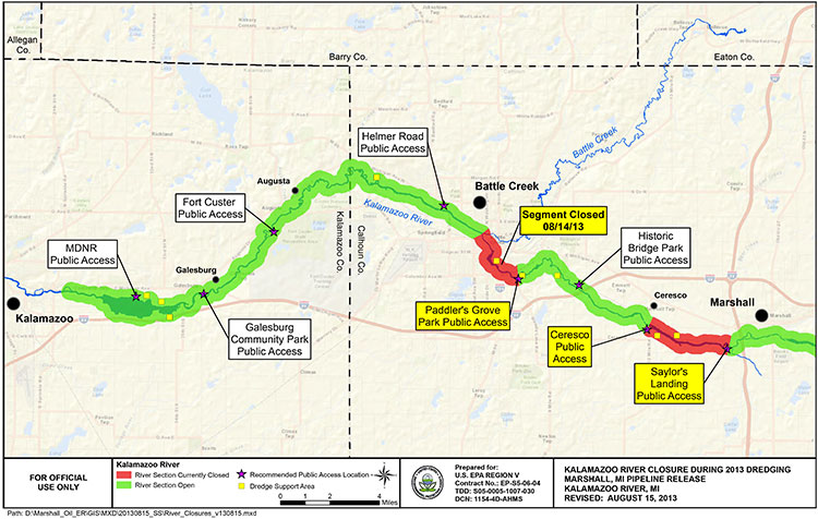
EPA map of river closures and dredging operations on the Kalamazoo River during 2013. (EPA)

Enbridge has missed the US Environmental Protection Agency’s deadline to clean up parts of the Marshall, Michigan bitumen spill by December 31, 2013.

Local television news, WOOD-TV says the EPA is now considering “enforcement options.”
The EPA had already granted Enbridge a 10 month extension that the company requested in March, 2013, setting the new December deadline.

In November, Enbridge requested a second extension. The EPA denied that request.

From the EPA letter it appears that, as in previous years, Enbridge is trying to avoid continuing clean up work into the winter. The EPA rejects that position, telling Enbridge it shouldn’t wait until the spring run off could spread the sunken bitumen.

The EPA says that beginning in March, 2013, “Enbridge has successfully removed oil and sediment from two of the three major impoundment areas identified in the order and from several smaller sediment trap locations.”

The area that Enbridge failed to clean up is known as the Morrow Lake and Morrow Lake Delta. The cleanup in that area was delayed when the Comstock Township planning commission unanimously  denied Enbridge a permit for “dredge pad” after fierce public opposition

The letter to Enbridge, from Jeffrey Kimble, Federal On-Scene Coordinator denying the extension is another scathing indictment of Enbridge’s attitude toward the public and the cleanup, citing Enbridge failing to prepare “adequate contingency plans,” by failing to recognize the “serious opposition” the dredging plans.

Although the EPA had told Enbridge to consider alternative plans—and Enbridge claimed it did that—the EPA found the Enbridge’s own logs showed the company didn’t start considering alternatives until it was obvious that Comstock Township would reject their dredging plans.

The EPA letter also reveals that once again Enbridge is reluctant to do further cleanup work during the Michigan winter. The EPA rejects that stance, saying that “Removal of oiled sediments prior to the spring thaw will lessen the potential oiled sediment transport in the spring to Morrow Lake via increased river velocities from rain and ice melt.”

Although we recognize that the work required by the Order is unlikely to be completed by December 31, 2013, U.S. EPA believes that had Enbridge taken appropriate steps earlier as requested, it would not require an extension now. In particular, U.S. EPA believes that Enbridge has continuously failed to prepare adequate contingency plans for a project of this nature. For example, U.S. EPA acknowledges that failure to obtain a site plan approval for use of the CCP property for a dredge pad was a setback in the timely completion of the work in the Delta.

However, Enbridge failed to prepare any contingency plans recognizing the possibility of such an occurrence. Enbridge has known since at least the middle of July 2013 that there was serious opposition to its proposed use of the CCP property. When it became clear in August 2013 that opposition to the site use might delay the project, U.S. EPA directed Enbridge to “conduct a more detailed review of your options in short order.”

Although your letter claims that Enbridge “has considered such alternatives,” your logs indicate that Enbridge did not hold initial discussions with the majority of these property owners until long after the final decision to abandon plans for use of the CCP property. These contact logs do not demonstrate that Enbridge fully explored and reviewed alternative options in a timely manner so as to avoid delay in completion of the work. Although Enbridge claims that use of identified alternative properties would be denied by Comstock Township, Enbridge did not present any site plans to the Township for approval (other than use of the county park for staging of frac tanks). To the extent that any of Enbridge’s contingency plans include the use of land for dredge pads, U.S. EPA believes that Enbridge should begin multiple submissions for property use until one is accepted….

Enbridge claims that it cannot install winter containment in the Delta to prevent the potential migration of sediments to the lake. To support that claim, Enbridge has attached a letter from STS directing Enbridge to remove anchors and associated soft containment during winter monthsas these structures could damage STS’s turbines. However, none of the correspondence provided by Enbridge discusses the use of more secure containment methods, such as metal sheet piling, which may not pose the same risks as soft containment structures. Enbridge should consider using sheet piling to construct cells which would both allow winter work and contain the sediment during that work. Enbridge should therefore try to obtain access from STS for this specific work, and for other appropriate work, for the winter timeframe. Use of sheet pile cells would allow continued operations during the winter, especially in the southern zone of the Delta outside of the main river channel. Removal of oiled sediments prior to the spring thaw will lessen the potential oiled sediment transport in the spring to Morrow Lake via increased river
velocities from rain and ice melt.

Finally, U.S. EPA is unwilling to allow Enbridge to wait until after the likely spring high
velocity river flush to reinstall the E-4 containment structures. U.S. EPA has reviewed Enbridge’s modeling, which Enbridge claims supports its requested timeline, and has found it incomplete. The model has not incorporated, and does not match, field observation of flow velocities and water levels and their potential to impact upstream critical structures if containment is in place. Moreover, U.S. EPA completely disagrees with Enbridge’s assertion that there is no evidence of migration of submerged oil during high flow events. The results of three years of poling and sheen tracking demonstrate that Line 6B oil is mobile during periods of
high flow. Now that Enbridge has a five year permit from MDEQ for the E-4 containment system, U.S. EPA reiterates that this containment must be in place immediately upon thawconditions in the spring….

Although Enbridge’s proposed two phase approach may have components that can be incorporated into a final plan, it should not be considered the approved way forward. U.S. EPA believes that pausing the work cycle until new poling can be done in June or July of 2014 could again result in a wasted construction season in the Delta. Enbridge should consider and utilize a combination of techniques in the plan. For example, several dredge pad sites have been identified by Enbridge. Enbridge should obtain approval for one of these sites, or a combination of smaller sites, so as to support hydraulic dredging in conjunction with the current approved
approach and any potential dry excavation techniques. Enbridge should also consider other winter work techniques, such as cell build out and dewatering in the Delta via sheet piling.

As always, U.S. EPA will continue to work with Enbridge to develop adequate plans and complete the work required by the Order. However, nothing in this letter excuses any noncompliance with the Order nor does it serve as the granting of any extension to any deadline in the Order. U.S. EPA reserves all its rights to pursue an enforcement action for any noncompliance with the Order.

The EPA letter also calls into question the ruling of the Joint Review Panel on the Enbridge Northern Gateway. The JRP accepts, without question, Enbridge’s assurances that the company has changed its attitude and policies since the long delay in 2010 in detecting the pipeline rupture in Marshall, Michigan.

The JRP, on the other hand, accepts, without question, Enbridge’s assurances that it has expertise in winter oil recovery from a pipeline spill.

Parties questioned Northern Gateway about locating and recovering oil under ice. Northern Gateway said that Enbridge conducts emergency exercises in winter and that Northern Gateway would learn from those experiences.
Northern Gateway outlined a number of oil detection techniques including visual assessment (at ice cracks and along the banks), drills, probes, aircraft, sniffer dogs, and trajectory modelling. It said that, once located, oil would be recovered by cutting slots into the ice and using booms, skimmers, and pump systems to capture oil travelling under the ice surface.

The company said that oil stranded under ice or along banks would be recovered as the ice started to melt and break up. It discussed examples of winter oil recovery operations during Enbridge’s Marshall, Michigan incident, and said that operational recovery decisions would be made by the Unified Command according to the circumstances.

Northern Gateway said that equipment caches would be pre-positioned at strategic locations, such as the west portal of the Hoult tunnel. It said that decisions regarding the location or use of pre-positioned equipment caches would be made during detailed design and planning, based on a number of considerations including, but not limited to, probability of a spill, access, site security,
environmental sensitivities, and potential for oil recovery at the response site.

(vol 2 page 153)

In its ruling, the Joint Review Panel said

The Panel finds that Northern Gateway’s extensive evidence regarding oil spill modelling, prevention, planning, and response was adequately tested during the proceeding, and was credible and sufficient for this stage in the regulatory process.
Parties such as the Province of British Columbia, Gitxaala Nation, Haisla Nation, and Coalition argued that Northern Gateway had not provided enough information to inform the Panel about proposed emergency preparedness and response planning. The Panel does not share this view.

Northern Gateway and other parties have provided sufficient information to inform the Panel’s views and requirements regarding malfunctions, accidents, and emergency preparedness and response planning at this stage of the regulatory process.

Many parties said that Northern Gateway had not demonstrated that its spill response would be “effective.” Various parties had differing views as to what an effective spill response would entail.

The Panel is of the view that an effective response would include stopping or containing the source of the spill, reducing harm to the natural and socio-economic environment to the greatest extent possible through timely response actions, and appropriate follow-up and monitoring and long-term cleanup. Based on the evidence, in the Panel’s view, adequate preparation and planning can lead to an effective response, but the ultimate success of the response would not be fully known
until the time of the spill event due to the many factors which could inhibit the effectiveness of the response. The Panel finds that Northern Gateway is being proactive in its planning and preparation for effective spill response….

The Panel is of the view that an effective response does not guarantee recovery of all spilled oil, and that that no such guarantee could be provided, particularly in the event of a large terrestrial, freshwater, or marine spill.

The oil spill preparedness and response commitments made by Northern Gateway cannot ensure recovery of the majority of oil from a large spill. Recovery of the majority of spilled oil may be possible under some conditions, but experience indicates that oil recovery may be very low due to factors such as weather conditions, difficult access, and sub-optimal response time, particularly for large marine spills. …

To verify compliance with Northern Gateway’s commitments regarding emergency preparedness and response, and to demonstrate that Northern Gateway has developed appropriate site-specific emergency preparedness and response measures, the Panel requires Northern Gateway to demonstrate
that it is able to appropriately respond to an emergency for each 10-kilometre-long segment of the pipeline.

The Panel notes the concerns of intervenors regarding Northern Gateway’s ability to respond efficiently and effectively to incidents in remote areas, and its plan to consider this during detailed design and planning. The Panel finds that Northern Gateway’s commitment to respond immediately to all spills and to incorporate response time targets within its spill response planning is sufficient to
address these concerns. Northern Gateway said that its emergency response plans would incorporate a target of 6 to 12 hours for internal resources to arrive at the site of a spill. It also said that it would target a response time of 2 to 4 hours at certain river control points.

The Panel agrees with Northern Gateway and several intervenors that access to remote areas for emergency response and severe environmental conditions pose substantial challenges. The Panel notes that the company has committed to develop detailed access management plans and to evaluate contingencies where timely ground or air access is not available due to weather, snow, or other logistic
or safety issues.

Despite the EPA letter (which admittedly was released long after the JRP evidentiary deadline) that shows that Enbridge did not consult the people of Comstock Township, Michigan, the JRP says

The Panel accepts Northern Gateway’s commitment to consult with communities, Aboriginal groups, and regulatory authorities. The objective of this consultation is to refine its emergency preparedness and response procedures by gaining local knowledge of the challenges that would be present in different locations at different times of the year
(Vol 2 p 165-167)

EPA letter to Enbridge denying deadline extension  (pdf)

Bitumen excluded from data for federal tanker study, documents reveal

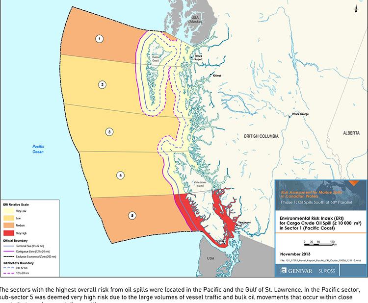
Tanker risk map
Transport Canada tanker report map shows current risk for spills in BC (Transport Canada)


Genivar report
Cover of Genivar tanker report (Transport Canada)


The possible effects of a bitumen spill on Pacific waters were not considered in the oil response preparedness report released last week by the Harper government, the background data study reveals.

The consulting firm that did the study for Transport Canada, Genivar Inc, had no reliable data on the effect of a bitumen tanker disaster—because, so far, there has been no major ocean disaster involving diluted bitumen.

Instead, Genivar, based its findings on potential hazards and response on existing data on crude oil spills.

The Genivar study, however, does warn, that if the Enbridge Northern Gateway project does go ahead,  the spill risk from diluted bitumen carrying tankers in Douglas Channel and along the north Pacific coast will jump from “low” or “medium” to “very high.” If the twinning of the Kinder Morgan pipeline goes ahead, then the risk in Vancouver also jumps to “very high.”

The question of how bitumen might behave in the cold and choppy waters of the North Pacific was hotly debated during the Northern Gateway Joint Review hearings earlier this year. Enbridge Northern Gateway based its position on laboratory studies, studies that were challenged by environmental and First Nations intervenors, pointing both to the unknowns of the ocean environment and the continuing problems Enbridge has in cleaning up the spill in the Kalamazoo River in Michigan.

Genivar tried to base its report to Transport Canada on existing data on oil spills and related hazards. What it found instead is that that there are often gaping holes in the reporting and monitoring of oil spills world wide, especially small and medium sized spills.

Lack of data also meant that Genivar had little to go on when it calculated the effect on an oil spill on key areas of interest to northwest British Columbia, the recreational fishery and tourism.
Genivar, however, did uncover disturbing data about the long term effects of oil spills, studies that show even minute amounts of remaining oil can still disrupt the marine environment 40 years after an event.

The Genivar report, Risk Assessment for Marine Spills in Canadian Waters Phase 1: Oil Spills South of 60th Parallel, was completed in November, then passed on to the “expert panel” that released their own report: A Review of Canada’s Ship-source Oil Spill Preparedness and Response Regime — Setting the Course for the Future. That second report was based not only on the data provided by Genivar but on the expertise of three panel members, their visits to some locations and input from government, industry, First Nations and municipalities.

Transport Minister Lisa Raitt and Natural Resources Minister Joe Oliver unveiled the second report at a glitzy media event  in Vancouver on Tuesday, December 10. At that time the expert panel report was released to the media along with an abstract of the data.

The actual data report was not posted; it had to be requested through the Transport Canada website, which is how Northwest Coast Energy News obtained the background study.

High risk for Kitimat

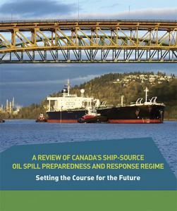
Transport Canada tanker report
Expert panel tanker risk assessment report cover (Transport Canada)

The expert panel found “a very high risk” of oil spills in two areas of the Pacific Coast, in the north around the ports of Kitimat and Prince Rupert and in the heavy ocean traffic area of southern British Columbia, especially Port Metro Vancouver and into Washington State.

The expert panel made 45 recommendations that covered a wide range of issues including eliminating the present $161-million liability limit for each spill and replacing it with unlimited liability for polluters, annual spill training involving the Canadian Coast Guard, Environment Canada, provincial and local authorities and the private sector, increased and improved annual spill training exercises, basing risk assessment on local geography and conditions and faster emergency responses to spills.

The expert panel calls for greatly increased research on the ocean environment at a time that Harper government has been gutting environmental research across Canada, while spinning that its policies are “science based.”

The science and technology around both the movement of oil and spill response has advanced significantly over the past several decades. We feel that while some aspects of the Regime have kept pace with these developments, in some areas, Canada has fallen behind world-leading countries like Norway and France. This can be attributed to a general lack of investment in research and development as well as the lack of coordination between industry and government over research priorities.

The Government of Canada should work closely with industry to establish a national research and development program for oil spill preparedness and response. The program should be co-funded by industry and the Government, and the research priorities should be set through a collaborative process that involves academia, where possible. Like the Regime itself, we view this program as a partnership between industry and government.

We envision that this program would also seek to leverage the work being done internationally on oil spill preparedness and response. The program should seek to establish partnerships with other world-leading countries in order to stay current on international advances and new technologies.

The expert panel, however, does not say how the federal government is expected to pay for meeting BC Premier Christy Clark’s condition for a “world class” spill prevention and response system at a time that Finance Minister Jim Flaherty is determined to balance the budget and the Harper government is continuing to cut back government services.

Bitumen excluded

On bitumen, the Genivar data study says:

Modified bitumen products represent the majority of the “crude carried as cargo” in
Pacific sub-sector 5. They are not modelled as a separate category in this spill behaviour analysis but are represented as “persistent crude”.

Changes in spill behaviour depend to some extent on the environmental conditions at the time of the spill, as described in greater detail below. However, over the range of wind and sea conditions typically experienced in the Canadian marine environment, changes in oil properties are not overly sensitive to variations in climatic values, so a single set of wind and sea conditions will be used in the analysis.

The idea that “changes in oil properties” not being sensitive to variations in climate was also frequently challenged before the Joint Review Panel.

On the increase in traffic volume if the Northern Gateway project goes ahead, the Genivar report says.

Enbridge Inc. has proposed to construct a marine terminal at Kitimat, B.C. and a dual pipeline from the terminal to oil sands production in northern Alberta. The terminal would handle up to 193,000 barrels/day of imported diluents (i.e., low-gravity condensate) that would be piped to Alberta and used to dilute bitumen to enhance its flow properties. The diluted bitumen would then be piped to Kitimat at rates up to 525,000 barrels/day that would be shipped by tanker to export to markets in Asia and California.

At full capacity, the import of diluent and export of diluted bitumen would total up to 35 Mt/year. This amount is comparable to the currently-shipped volume in the Pacific sector related to volumes being exported from Vancouver and related to volumes being exported from the Alaskan to Washington State trade.

It goes on to say that the current tanker traffic on the north Pacific coast “has negligible risk in the near shore and intermediate zones, but significant potential spill frequency in the deep-sea zone related to the Alaskan trade.” Similarly, according to Genivar the environmental risk in the region “currently ranges from ‘medium’ to “very low” from near shore to deep-sea zones, respectively…. mainly driven by a combination of physical and biological features.”

The increase in traffic from Northern Gateway would likely increase the environmental risks. The the near shore risk from would jump from “very low” to “very high.” For the largest spill category, deep-sea risk would likely increase from “low” to “medium.”

No data on recreational or traditional First Nations fishery

To study the effect on an oil spill on the fishery, Genivar used data from the Department of Fisheries and Oceans as the provinces to gauge “the port value of commercial fishing and the value of the fish, shellfish and aquaculture” in each zone it studied and then compared it to the the national averages for commercial fishery. Those figures included any commercial fishery by First Nations.

But Genivar noted, there is no reliable data on either the recreational fishery or the First Nations traditional, food, social and ceremonial fishery, saying:

It is important to highlight that this indicator does not consider recreational or traditional fishing. The importance of this industry is notable and an oil spill could damage the recreational fishing stock as well. However, the absence of comparable data and the fact that this study is restricted to federal and international data, and some provincial data from Quebec and Ontario for commercial fisheries, limits the ability to include recreational fishing… Nevertheless, as an absolute index, it will provide an overall vulnerability in the event of an oil spill.

The ongoing impact of cutbacks at Fisheries and Oceans has had a continuing impact on the northwest, especially in the controversial halibut recreational fishery, where DFO has admitted that it is basically guessing the size of each year’s recreational halibut catch.

Tourism

Genivar also notes that lack of reliable data on the effect on a oil spill on tourism. The consultants go so far as to say one of the indicators they will use to measure the effect of any oil spill on tourism would come from “data extracted from the 2011 National Household Survey at the census division level and the accommodation and food services data will be used.”

The “National Household Survey” is also known as the long form census and it is the National Household Survey that the Harper government made voluntary rather mandatory, decreasing the reliability of the data. Global News recently analyzed those who had contributed to the survey and found that it poor people, the very rich and people in low population areas were least likely to fill out the voluntary census—which means the data for northwest BC is likely highly unreliable from the 2011 survey even though “The census divisions in coastal regions will be selected for each of the sub-sectors. This method will express the economic vulnerability of each sub-sector to a potential collapse in tourism following a spill.”

Despite the importance of cruise ship traffic on the west coast, Genivar notes, “In Canada, data for passenger vessels were unavailable.”

It also notes that “this study does not specifically take into account national parks and other landmarks, since their influence on tourism is indirectly included in the tourism employment
intensity index” so that Genivar could create what it calls the Human-Use Resource Index (HRI), even though that index appears to be based on incomplete data.

Commentary: In the tanker study, the District of Kitimat was missing in action

kitimatlogoThe list of participants in the oil spill preparedness and response study released last week by the federal government shows two glaring no shows, the District of Kitimat and Rio Tinto Alcan.
The Haisla Nation and the Gitga’at Nation did provide written submissions to the panel.

The expert panel was set up by the federal government to review “oil handling facilities and ship-source oil spill preparedness and response.” The expert panel was to review the “structure, functionality and the overall efficiency and effectiveness of the system, as well as analyzing the requirements for hazardous and noxious substances, including liquefied natural gas.”

Transport Canada tanker report
Expert panel tanker risk assessment report cover (Transport Canada)

As well as commissioning the Genivar report on the state of oil spill preparedness and consequences, the panel interviewed stakeholders and visited a few key locations, including Port Metro Vancouver.

The panel also invited any interested groups to submit documents or their own views to be taken into consideration.

Among the stakeholders interviewed by the panel were companies and organizations very familiar to Kitimat; Chevron and Shell, main partners in two of the LNG projects; Enbridge, which has proposed the Northern Gateway Pipeline and Kinder Morgan which has proposed expanding the dilbit pipeline on the Lower Mainland. Other stakeholders included Coastal First Nations, the Prince Rupert Port Authority, SMIT Marine and the Vancouver Port Authority.

As well as the Haisla and the Gitga’at, five west coast municipalities submitted their own reports to the tanker panel, both the city and districts of North Vancouver, the city of Richmond, the District of Ucluelet and the District of West Vancouver. San Juan County in Washington State also made a submission to the panel. So did the Prince Rupert and Vancouver Port authorities.

Chevron, Enbridge, Imperial Oil, Kinder Morgan, Pacific Northwest LNG, Seaspan Marine, and the Union of BC Municipalities, among others also submitted their views to the panel.

So why didn’t the District of Kitimat participate? When it came to the Enbridge Northern Gateway Joint Review, the mayor and council always maintained their neutrality motion meant that the District would not be an active participant. That was always a short sighted viewpoint. The District should have participated actively in the JRP in such a way as to protect the region’s interests where necessary while remaining neutral. If the District of Kitimat sat out the tanker panel because of the Northern Gateway neutrality policy, that was no excuse, because the expert panel’s mandate specifically included LNG.

Tanker traffic is a potential threat to the San Juan Islands (the Gulf Islands on the American side of the border). It is astounding that San Juan County would think that the Canadian tanker panel was important enough to make a submission and the District of Kitimat did not.

RTA logoWhat about Rio Tinto Alcan? Kitimat has been a private port for 60 years, run first by Alcan and then by Rio Tinto Alcan. Why wasn’t RTA asked to participate as a stakeholder? Why didn’t RTA make a submission? Those who are pushing the Northern Gateway terminal always like to say that tankers have been calling at Kitimat for those 60 years. That is true. Of course, none of those tankers have been the Very Large Crude Carriers proposed by Northern Gateway. However, those 60 years means that RTA has the expertise on the Port of Kitimat and Douglas Channel. RTA probably has important data that could have helped both the expert panel and Genivar (which pointed out the paucity of data on small and medium sized tankers). In not participating in the tanker panel submissions and possibly not providing valuable data on Douglas Channel, RTA neglected its social responsibility both to the community of Kitimat and the rest of the province of British Columbia.

Tanker study shows huge gaps in shipping and hazard data, documents show

The study of tanker shipping and tanker spills by Genivar for Transport Canada has revealed huge gaps in how the world monitors tanker traffic.

Genivar report
Cover of Genivar tanker report (Transport Canada)

Genivar says

Accident data was acquired from three main sources: the CCG Marine Pollution Incident Reporting System (MPIRS); the Lloyd’s casualty database; and spill incident records maintained by the International Tanker Owners Pollution Federation (ITOPF).

MPIRS lists all marine pollution incidents occurring in Canadian waters (CCG, 2013), with information on the region within Canada in which the incident occurred, type of material spilled, accident cause, and estimated pollution volume with multiple entries for a given incident showing updates of incident status and pollution amounts if applicable. The primary use of MPIRS in this study was for spill incidents in the smaller size categories… for which worldwide data was suspected to be unreliable due to under-reporting. MPIRS appeared to be a comprehensive listing of incidents that occurred in Canadian waters, and a summary of polluting incidents

It goes on to note that some key data has not been updated since the 1990s, largely prior to the introduction of double hulled tankers.

As noted, oil spill accidents were compiled on a worldwide basis.

In order to estimate the frequency for Canada, an exposure variable was required.

A series of studies by the U.S. Minerals Management Service (MMS, now known as
the Bureau of Ocean Energy Management, Regulation and Enforcement) investigated the occurrence rates of tanker accidents against various spill exposure variables and found that the simplest and most reliable indicator was volume of oil transported. Simply put, it was determined that spill rates could be expressed, for a range of spill size categories, as an average number of spills per billion barrels transported.

The MMS studies were updated periodically until the 1990s but have not been revisited since, but they did show a steady decrease in the likelihood of casualties and resulting spill volumes, due to a number of factors including tanker design, increasing governance and overall scrutiny of the marine transportation industry. The phased-in implementation of double-hull tankers may have also had a beneficial effect on spill rates in more recent years, particularly in the category of very large or catastrophic events… In any case, it is important in interpreting accident data to reflect current trends and implemented mitigation measures. The focus was on cargo volumes and accident rates over the past decade.

It goes on to say the volumes of crude carried is also under-reported to Lloyds.

In the case of crude oil and refined products carried as cargo, the exposure variable was simply the volume of each respective category carried on an annual basis for the period of interest. Information from the Lloyds APEX database was used for this purpose; it reports volumes of crude and refined products shipped worldwide, with a breakdown by year, country of origin, and country of destination. Compared with similar data from Canadian sources, the APEX data appeared to significantly under-report the carriage of refined products. As a result, the accident rates estimated and used in this study are likely somewhat conservative, that is, they overstate the likely frequency of refined products carried as cargo. For all calculations involving the potential spillage of refined products as cargo in Canadian waters, and for the apportioning of spill frequency among the various sectors and sub-sectors of Canada, Transport Canada commodity traffic data was used

Again about Lloyds data, until 2010, it was limited in its monitoring of the BC Coast.

In analyzing the Canadian movement data supplied by Lloyds, a major shortcoming was found in the data in that movements recorded prior to 2010 did not include broad classes of vessels such as ferries, passenger vessels, and pilot boats. Given that these vessels comprise a significant proportion of traffic movement in many sectors, only data covering the final two years of the record, 2010 and 2011, were used in the analysis.

The Lloyds data was also limited when it came to oil spills:

One limitation of the MPIRS data was that it did not classify spills as to whether they were from “cargo” as opposed to “fuel”, which would have been helpful in this study as these spill types were analyzed separately. As a result, for spills of refined products, which could have hypothetically been either cargo or fuel, assumptions were made based on the type of vessel involved, the type and severity of the incident, and other notes within MPIRS.

A database was acquired from Lloyds that detailed all marine casualties over the
past ten years regardless of whether the incident involved pollution…
This database was used to provide a breakdown of incidents by cause, and as an
initial listing of those incidents that did result in pollution. The Lloyds data was of
mixed quality when it came to the reporting of polluting incidents, with numerous
records only partially filled out, ambiguities in the reporting of spill volume, and
inconsistencies in the classification of the spilled material. A significant effort was
made to provide consistency and accuracy in the information, including cross-
referencing with other data sources.


So the Genivar report exposes a significant gap in the available data on oil spills.

It is certainly true that the number of major tanker accidents and spills have decreased since the Exxon Valdez disaster, a point frequently made by Enbridge at meetings in northwestern BC.

The expert panel report which said that Canada faces the risk of a major tanker disaster of 10,000 tonnes or more once every 242 years.

The Vancouver Sun quoted Transport Canada spokeswoman Jillian Glover on that risk of a spill on the Pacific Coast as saying. “This value must be understood in relative terms, such that the risk is considered high compared to the rest of the country only…Canada enjoys a very low risk of a major oil spill, evidenced by the lack of Canadian historical spills in the larger categories. Additionally, this risk assessment is before any mitigation measures have been applied, so that is a theoretical number before additional prevention initiatives are taken.”

Note that the government always talks about a “major oil spill,” but it appears from the gaps in the data that predicting the possibility and consequences of a medium sized or smaller oil spill is now not that reliable, even though such a spill could have disastrous effects on a local area. According to a map in both reports, the entire BC coast is at risk for a “low to medium” spill. This echoes the problems with the Enbridge Northern Gateway pipeline, where Enbridge based most of its projections on a “full bore breach” or major pipeline break and did little about a medium sized or smaller leak. Data analysis by Kelly Marsh of Douglas Channel Watch on the possibility of the cumulative effects of a medium sized and possibly undetected pipeline breach could have just as disastrous consequences for the Kitimat valley as a major pipeline break. The same is likely true at sea.

Oil spill dangers can linger for 40 years, report shows

Genivar report
Cover of Genivar tanker report (Transport Canada)

The Genivar report for Transport Canada on oil spills say that some persistent effects can last for more than 40 years, based on a study of a spill in Cape Cod, Massachusetts. The report  notes that persistent sub-surface oil is still a problem at Prince William Sound, site of the Exxon Valdez disaster in 1989.

On long-term effects, Genivar reports: “The ingestion of contaminated food (such as oiled mussels), may represent the most important exposure pathway for aquatic fauna during a chronic
phase. Chronic exposure to contaminated sediments is also important for fauna or
vegetation.”


It goes on to stay that “large-scale oil spills might have considerable long-term
consequences on social structure and public health, interfering with traditions and
causing cultural disruptions.”

It appears that in the case of an oil-spill, time may heal some wounds, but not all of them, at least if time is considered within human lifetimes and the lifetimes of other species.

Ecological recovery is measured by how quickly individuals and populations of
species return to pre-spill conditions. It is determined by factors such as oil type,
exposure duration, water temperature, degree of weathering, spill response and the
individual and species-specific life history traits. In most environmental habitats,
recovery is completed within 2-10 years after a spill event, but in some exceptional
cases, such as in salt marshes, effects may be measurable for decades after the
event.

In the case of the Exxon Valdez oil spill in Prince William Sound… in 1989, the persistence of sub-surface oil in sediments and its chronic exposure continues to affect some of the wildlife through delayed population reductions, indirect effects and trophic interactions 20 years beyond the acute phase of the spill.

It then goes on to stay that

Four decades after the oil spill In Wild Harbor (USA), Spartina alterniflora beds had a reduced stem density and biomass and mussels in oiled locations showed decreased growth and filtration rates.

According to a Boston Globe story, published at the time of the Deepwater Horizon oil leak in the Gulf of Mexico, in 2010, the Wild Harbor, an oil barge ran aground near Cape Cod in September, 1969, spilling 200,000 gallons of fuel, some of which is still there.

The Boston Globe story noted:

Today, Wild Harbor looks much like any other Cape Cod marsh, but the oil below the surface affects its resiliency. Fiddler crabs normally burrow deep down, funneling oxygen to the roots of marsh grass. Here, they stop digging when they reach the oil, turn sideways, and burrow back to the surface. They also act “drunk’’ from the oil they ingest, and predators can catch them more easily, research shows.

The Woods Hole Oceanographic Institute has been studying the Wild Harbor spill for the past 40 years.

At a recent conference, Dr. John Teal updated scientists on the “multi-decadal effects” of the Wild Harbor spill. According a blog on the conference:

At the time of the 1969 spill, lobsters, clams, and fish died by the thousands, but most people believed the harm would be temporary, reflecting the conventional wisdom of the time. Barge owners and oil industry experts even told residents that most of the oil would evaporate and any damage would only be short-lived. However, researchers at WHOI were not so sure and immediately began cataloging species and tracking where the oil was and kept at it for years. The researchers understood that the immediate, short term effects of oil pollution were already obvious and fairly well-understood, but that everyone was rather ignorant about the long-term and low-level effects of an oil spill….

Beginning three to five years after the spill, marsh grasses and marsh animals were again occupying most of the oiled area. An observer unfamiliar with Wild Harbor would not have been able to visually detect the oiled areas after just 10 years, and by the second decade after the spill, the marsh’s appearance had returned to normal. However, the WHOI researchers pointed out that for more than a decade after the spill, an oil sheen still appeared on the surface of the water when mud from the most heavily oiled parts of the marsh was disturbed….

In 2007, WHOI researchers documented that a substantial amount of moderately degraded petroleum still remained within the sediment and along eroding creek banks of the marsh oiled in 1969. They also demonstrated that the ribbed mussels that inhabit the oiled salt marsh, and are exposed to the oil, exhibited slower growth rates, shorter mean shell lengths, lower condition indices, and decreased filtration rates even when placed in a healthy marsh. Researchers have also documented detrimental effects of the 1969 oil spill on the salt marsh plants themselves.


Related Oil Spill on the Wild Harbor Marsh by John M. Teal and Kathryn A. Burns
The Genivar report goes on to note:

Long-term effects on the population in the aquatic environment (especially on mobile fauna) are especially difficult to confirm. Benthic [bottom dwelling] invertebrates may be more at risk than fish species due to the fact that more or less sessile organisms are likely to suffer higher initial rates of mortality and exhibit long recovery times as a result of
exposure to oil-saturated habitats.

Nearshore demersal [bottom-dwelling] fish can also suffer from long-term chronic exposure, as indicated in masked greenlings and crescent gunnels by biomarkers on hydrocarbons 10 years after the Exxon Valdez spill. Mortality in sea ducks and sea turtles due to chronic exposure was also reported many years after the spill and other results indicate that effects on cetacean populations can last beyond 20 years after the acute exposure phase.

As for the recovery of the economy after a spill, Genivar notes it is based “on the time required for effected industries to be fully restored to pre-spill conditions.

The length of time required is influenced by the duration of the aquatic area closures (e.g. commercial fisheries, recreational fisheries), the public perceptions on seafood safety and the perceived effects of the aesthetic quality of the environment. Even after the full ecological recovery of the aquatic resources, fisheries can be far from reestablished, as is still the case for herring fisheries in the Exxon Valdez spill area…

As reviewed by Genivar, negative perceptions associated with the quality of fishery products, even for fisheries that have not been contaminated and also for regions not directly affected by the spill, can be far more important than the direct economic losses. This also holds true for the tourism sector and all other related spinoff sectors.

JRP refuses to consider latest DFO findings on Humpback Whales

The Northern Gateway Joint Review Panel has refused to consider the latest findings from the Department of Fisheries and Ocean on humpback whale critical habitat on the coast of British Columbia, including areas of ocean that could be on the route of tankers carrying diluted bitumen from Kitimat.

On October 21, 2013, Fisheries and Oceans released a report called Recovery Strategy for the North Pacific Humpback Whale (Megaptera novaeangliae) in Canada. The DFO report notes that humpback whales are a species of “special concern” by the Committee on the Status of Endangered Wildlife in Canada.

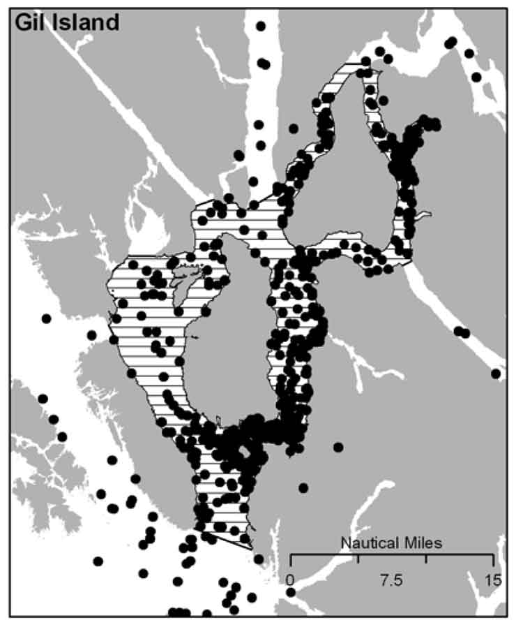
It is DFO policy to assist the humpback whale population to recover from the century of whaling that almost drove the species to extinction. The report identified four areas of “critical habitat” for humpbacks. One critical habitat zone is Gil Island at the mouth of Douglas Channel.

DFO map of humpback habitat
DFO map of humpback sightings on the BC coast. (DFO)

Last week, on November 13, Smithers based environmental activist Josette Weir filed a notice of motion with the JRP requesting that the panel consider the DFO report as late evidence.

Weir acknowledged that the JRP proceedings closed on June 24, after final arguments in Terrace, but she noted that rules allow the Board to override the final closure. She argued that the humpback report fell within the JRP’s mandate since the DFO report is “is likely to assist the Panel.”

Weir noted in her motion that there was insufficient information before the JRP that would identify critical humpback habitat.

She argued:

Three of the four critical known habitats are on the proposed tanker routes, and the Recovery Strategy acknowledges that other areas have not been identified. Without such information, it is impossible to assess the potential effects of the marine transport of bitumen on this endangered species.Activities likely to destroy or degrade critical habitat include vessel traffic, toxic spills, overfishing, seismic exploration, sonar and pile driving (i.e., activities that cause acoustic disturbance at levels that may affect foraging or communication, or result in the displacement of whales).

The report clearly identifies vessel traffic and toxic spills, which are associated with the Project as potential causes for destruction or degradation of the Humpback Whales’ critical habitat.

Weir went on to argue that the JRP had “insufficient information to develop relevant protection measures” because the humpback studies are ongoing, “meaning their results will not be available before decision.”

The Panel must consider this significant risk to an endangered listed species for which no meaningful protection measure can be offered against the risks associated with the Project.

Weir also noted that “No similar submission has been made by others, but I cannot predict if others will not see fit to do so.”

The JRP didn’t take long to reject Weir’s request, replying the next day, November 14.

In its response, the JRP cited the amended Joint Review Panel Agreement, signed after the passage of of the Jobs, Growth and Long-term Prosperity Act, the Omnibus Bill C-38, that “provides that the Panel’s recommendation report is to be submitted to the Minister of Natural Resources by 31 December 2013.”

The JRP then told Weir it didn’t have jurisdiction over endangered species (even if those species inhabit the tanker route) saying:

The Panel notes that the Recovery Strategy has been released in accordance with the provisions of the Species At Risk Act, as part of a legislative scheme that operates independently of this joint review process.

It goes on to say: “In this case, the Panel also notes that the Recovery Strategy was not authored by or for Ms. Wier.”

Map of Gil Island
Humpback whale sightings at the Gil Island critical habitat. (DFO)

The executive summary of the DFO report noted:

Critical habitat for Humpback Whales in B.C. has been identified to the extent possible, based on the best available information. At present, there is insufficient information to identify other areas of critical habitat or to provide further details on the features and attributes present within the boundaries of identified critical habitat. Activities likely to destroy or degrade critical habitat include vessel traffic, toxic spills, overfishing, seismic exploration, sonar and pile driving (i.e., activities that cause acoustic disturbance at levels that may affect foraging or
communication, or result in the displacement of whales). A schedule of studies has been included to address uncertainties and provide further details on the critical habitat feature(s), as well as identify additional areas of critical habitat. It is anticipated that results from these studies will also assist in development of relevant protection measures for the critical habitat feature(s).

In the part of the report on the danger of toxic spills to humpbacks, the DFO report mentions that sinking of the BC ferry Queen of the North:

Toxic spills have occurred impacting marine habitat along the B.C. coast. For example, the Nestucca oil spill (1988) resulted in 875 tonnes of oil spilled in Gray’s Harbor, Washington. Oil slicks from this spill drifted into Canadian waters, including Humpback Whale habitat. In 2006, a tanker ruptured in Howe Sound, B.C. spilling approximately 50 tonnes of bunker fuel into coastal waters. In 2007, a barge carrying vehicles and forestry equipment sank near the Robson Bight-Michael Bigg Ecological Reserve within the critical habitat for Northern Resident Killer Whales, spilling an estimated 200 litres of fuel. The barge and equipment (including a 10,000L
diesel tank) were recovered without incident. When the Queen of the North sank on March 22, 2006, with 225,000 L of diesel fuel, 15,000 L of light oil, 3,200 L of hydraulic fluid, and 3,200 of stern tube oil, it did so on the tanker route to Kitimat, which is currently the subject of a pipeline and port proposal and within the current boundaries of Humpback Whale critical habitat

The DFO report also takes a crtical look at vessel strikes

In B.C. waters, Humpback Whales are the most common species of cetacean struck by vessels, as reported to the Marine Mammal Response Network. Between 2001 and 2008, there were 21 reports of vessel strikes involving Humpback Whales. Of these, 15 were witnessed collision events while the remaining 6 were of live individuals documented with fresh injuries consistent with recent blunt force trauma or propeller lacerations from a vessel strike.

Overall, vessel strikes can cause injuries ranging from scarring to direct mortality of individual whales. Some stranded Humpback Whales that showed no obvious external trauma, have been shown from necropsy to have internal injuries consistent with vessel strikes… It is unknown how many whales have died as a result of vessel strikes in B.C. waters. To date, only one reported dead Humpback Whale presented with evidence consistent with blunt force trauma and lacerations resulting from a vessel strike…

There are no confirmed reports of Humpback Whale collisions in B.C. waters attributed to shipping, cruise ship or ferry traffic. However, larger ships are far less likely to detect the physical impact of a collision than smaller vessels, and this could account for the lack of reported strikes. Collisions with large vessels may be more common than reported, especially in areas where larger vessel traffic is concentrated.

Despite the fact that collisions may only affect a small proportion of the overall Humpback Whale population, vessel strikes may be a cause for concern for some local and seasonal areas of high ship traffic.. In B.C., areas of high probability of humpback-vessel interaction include Johnstone Strait off northeast Vancouver Island, Juan de Fuca Strait off southwest Vancouver Island, Dixon Entrance and the “Inside Passage” off the northern B.C. mainland which include portions of two of the identified critical habitat areas..

The JRP also said

As the Panel has mentioned previously during the hearing, the later in the joint review process that new evidence is sought to be filed the greater the likelihood of the prejudice to parties. The Panel is of the view that permitting the Recovery Strategy to be filed at this late stage in the hearing process would be prejudicial to the joint review process.

Weir’s submission to the JRP did not mention an academic study published on September 11, 2013, that also identified Gil Island as critical humpback habitat.

RELATED:

“Conservatives’ hatred for science intentional part of their environmental policy,” Cullen says

DOCUMENTS:

DFO report on Humpback Recovery strategy  (PDF)

Josette Weir notice of motion on Humpback Whales (PDF)

Panel Commission Ruling on Humpback Whales (PDF)