Controlling land and pipelines key to Haisla LNG future NEB filing says

The Haisla Nation’s plan for entering the LNG business is based on the idea that “it is anticipated that the Haisla Projects will be developed using a business model based on controlling two components of the value chain: land and pipeline capacity” according to its application to the National Energy Board for a natural gas export licence.

Cedar LNG Development Ltd., owned by the Haisla Nation, filed three requests for export licences with the NEB on August 28, under the names Cedar 1 LNG, Cedar 2 LNG and Cedar 3 LNG.  Another name used in the application is the “Haisla Projects.”

The 25-year export licence request is standard in the LNG business; it allows export of natural gas in excess of projected North American requirements. Thus like the NEB hearings for the Kitimat LNG and LNG Canada projects it is not what is called a “facility” licence which is what Enbridge Northern Gateway requested.

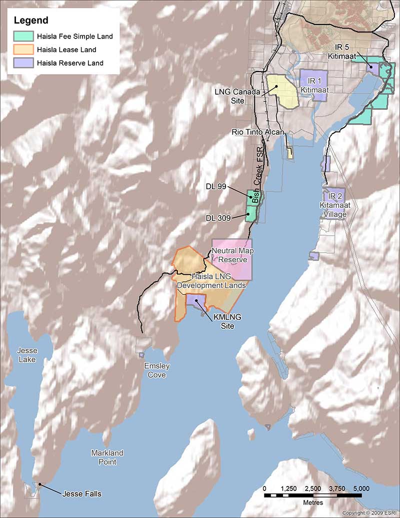
The project anticipates six “jetties” that would load LNG into either barges or ships at three points along Douglas Channel, one where the present and financially troubled BC LNG/Douglas Channel Partners project would be.

A second would be beside the BC LNG project, which may refer to the Triton project proposed by  Pacific Northern Gas parent company Altagas.

Both are on land now owned by the Haisla Nation in “fee simple” land ownership under Canadian law.

Map of Haisla LNG sites
Map from the Haisla application to the NEB showing that the Haisla Projects Region will allow for a total of six LNG jetty sites. One of these, on DL99, is currently ear-marked to be used for a project involving a consortium (BCLNG) One will be situated on the DL309 Haisla fee simple land and the other four jetties are to be  situated on the Haisla leased lands that surround the Chevron-led LNG development at Bish Cove. The map also shows that the Haisla own land at Minette Bay.

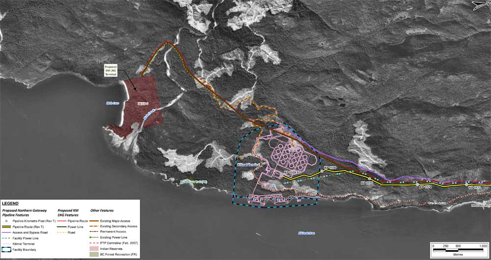
The other four would be on land surrounding the current Chevron-led Kitimat LNG project along Douglas Channel and in the mountains overlooking Bish Cove which the Haisla have leased.

Ellis Ross
Haisla Nation Chief Counsellor Ellis Ross at Bish Cove, June 19, 2013. (Robin Rowland/Northwest Coast Energy News)

The move last week and the revelation of the Haisla’s plans for the land are a cumulation of Haisla Nation Chief Counsellor Ellis Ross’s idea of restoring more of the First Nation’s traditional territory by buying or leasing the land using standard Canadian land law and at the same time getting around some of the more restrictive provisions of the Indian Act that apply to reserve land.

Just how the Haisla will go into the pipeline business is not as clear as the First Nation’s acquisition of the land. The application says:

The pipeline capacity required to transport sourced LNG to the Haisla Projects will include a mix of new and existing pipeline and infrastructure. The Haisla are in the advanced stages of negotiating and drafting definitive agreements with the major gas producers and pipeline transmission companies located in the vicinity with respect to securing pipeline capacity. It is expected that the Haisla Projects will rely on the Haisla’s business partners or customers to source gas from their own reserves and the market.

With the Haisla basing their business strategy on land and pipelines, the First Nation’s strategy is looking for  flexibility in what is a volatile and uncertain market for LNG.

The application says the Haisla “are currently in advanced stage discussions and negotiations with a number of investors, gas producers, LNG purchasers, pipeline transmission companies, technology providers and shippers. As such, the particular business models have yet to be finalized. However, it is anticipated that between the various Haisla Projects, multiple export arrangements may be utilized.”

As part of the idea of flexibility, the actual LNG infrastructure will be constructed and operated with potential partners. That is why there are three separate applications so that each “application will represent a separate project with independent commercial dealings with investors, gas producers, LNG purchasers, pipeline transmission companies, technology providers and shippers.”

The Haisla say that they are “working with a number of entities to develop business structures and partnerships to provide transaction flexibility, adequate financing, modern technology, local knowledge, and marketing expertise specific to Asian targets. The separate projects will accommodate expected production and demand and will also allow for a number of midlevel organizations to be involved with the various projects as well as traditional major gas producers and LNG purchasers.”

The Haisla are working with the Norwegian Golar LNG which had been involved in the stalled BC LNG project, using a Golar LNG’s vessels and technology, using a new design that is now being built in Singapore by Keppel Shipyard.

Golar LNG uses PRICO LNG  process technology developed by Black & Veatch,  (Wikipedia entry) “which is reliable, flexible and offers simplified operation and reduced equipment count.”

The filing says the project will “be developed using either barge-based or converted Moss-style FLNG vessels. The terminals will consist of vessel-based liquefaction and processing facilities, vessel-based storage tanks, and facilities to support ship berthing and cargo loading”

The jetties to be used for the Haisla Projects may be either individual FLNG vessels or “double stacked”, meaning that the FLNG vessels are moored side-by-side at a single jetty. The Haisla have conducted various jetty design work and site /evaluation studies with Moffat and Nichol.

The Haisla Projects anticipate that the construction will be in 2017 to 2020, “subject to receiving all necessary permits and approvals” and is expected to continue for a term of up to twenty five years. There is one warning, “The timelines of the Haisla Projects will also depend on the contracts and relationships between the Applicant and its partners.”

The filing goes on to say:

Haisla Nation Council and its Economic Development Committee are committed to furthering economic development for the Haisla. The Haisla’s business philosophy is to advance commercially successful initiatives and to promote environmentally responsible and sustainable development, while minimizing impacts on land and water resources, partnering with First Nations and non-First Nations persons, working with joint venture business partners, and promoting and facilitating long-term development opportunities.

The Haisla Applications will allow the Haisla to be directly involved as participants in Canada’s LNG industry, rather than having only royalty or indirect interests. The Kitimat LNG and LNG Canada projects, and the associated Pacific Trails Pipeline and Coastal Gas Link Pipeline, have increased economic opportunities in the region and the Haisla are very supportive of these projects locating within the traditional territory of the Haisla. The support of the Haisla for these two projects reflects a critical evolution of the Haisla’s economic and social objectives.

You can see the filing on the NEB projects page at http://www.neb-one.gc.ca/clf-nsi/rthnb/pplctnsbfrthnb/lngxprtlcncpplctns/lngxprtlcncpplctns-eng.html

Map from the Haisla Nation application to the NEB showing the proposed LNG developments in relation  to Douglas Channel.
Map from the Haisla Nation application to the NEB showing the proposed LNG developments in relation to Douglas Channel.
Bitumen map
Map from the Enbridge filing with the Joint Review Panel showing the same area with the proposed Northern Gateway bitumen terminal.


Kitimat votes: Ross calls Gateway plebsicite “late in the day” and “slap in the face”

Haisla Nation chief counsellor Ellis Ross has written a letter to Kitimat media sharply critizing the upcoming plebiscite on the Enbridge Northern Gateway project

Enbridge trying to buy Social Licence

This late in the day, a poll of its residents has no binding effect on the project. Next week, the District of Kitimat will seek the views of its residents on Enbridge’s Northern Gateway Pipeline Project. But to what end? If anything, it will lead to further uncertainty.

Deciding to hold a referendum at this late date is a slap in the face to all the work done by the Haisla Nation on this project. The Haisla Nation dedicated time and money toward testing Northern Gateway’s evidence and claims about safety and environmental protection, while the District stood by and did nothing.

The review process for this project has already left town, with the District taking no position on the project. Still undecided on what its views are on the project, the District now proposes to conduct a poll, instead of examining the facts in the JRP process. A poll to vote on a JRP report that we view as wrong to begin with including the flawed process itself!

Ellis Ross
Haisla Chief Counsellor Ellis Ross (Robin Rowland/Northwest Coast Energy News)
Based on our participation, the Haisla Nation has determined the risks associated with Northern Gateway’s transport of diluted bitumen and condensate clearly outweighs any potential benefits. This is an informed conclusion, made after reviewing Northern Gateway’s application and evidence, and participating extensively in the Joint Review Panel process.

The Haisla Nation is doing what it can to protect what is left of its Territory. The Joint Review Panel Report has failed to properly address the concerns associated with the project, which is why the Haisla Nation has asked the Federal Court of Appeal to review the JRP’s Report. And the Haisla Nation is not alone in its challenge of the Report. Two other First Nations – Gitga’at and Git’xaala – and two environmental organizations have also challenged the Report.

Enbridge Northern Gateway is desperate for public support. That is why it is conducting a media and canvassing blitz in the District to sway voters. Will the District of Kitimat be able to form a position based on the outcome of such a plebiscite, which would have been bought by oil money, instead of based on participating in a fact finding process like the JRP? What is a yes vote that has been bought by Enbridge’s vast advertising machine worth? Does a purchased social licence hold any value at all? If it does have a price tag, it doesn’t come close to the value that the Haisla people place on what is left of Haisla Territory; especially if you look at what has happened in the Gulf of Mexico, at Kalamazoo and the effects lasting even to today in Prince William Sound (Exxon Valdez).

The Haisla Nation will not be swayed by a yes vote in the District of Kitimat plebiscite. If anything, our membership is angry that it is even happening at all. This project is wrong for the Haisla Nation and it is wrong for the Territory that Haisla’s and non Haisla’s call home. We have a choice. We have more than enough projects to sustain the region and we are already seeing the results.

There is also some controversy in Kitimat whether or not members of the Haisla Nation should be able to vote in the April 12 plebiscite. District officials noted that its has jurisdiction only within District boundaries. That means that members of the Haisla Nation who live within the boundaries of the District can vote, while Haisla who live in Kitamaat Village, which is a federally designated Indian Reserve cannot.

Earlier in the week, Ross was equally blunt in a Facebook posting aimed at the Haisla Nation where he said:

The Kitimat Council’s ‘vote’ is an insult to Haisla given the amount of time, effort and money we’ve spent since 09 and they come in at the last minute to cheer lead for Enbridge but he vote wont mean anything regardless of the outcome.

District of Kitimat can’t make this project happen even if its a yes vote. We will make our position known to both this vote and our reaffirmation of this project and its impacts to our rights and title.
Haisla members: remember what we’ve been saying about this in our membership meetings since 09.

On Monday, in an Op Ed in the Vancouver Sun, Clarence Innis, acting chief of the Gitxaala Nation, wrote, in part:

We, the Gitxaala Nation, are vehemently opposed to Enbridge’s proposed Northern Gateway pipeline project because of the disastrous effects the shipment of heavy oil through our territory would have on our traditional way of life, economy, spirituality, and governance system….
What’s especially concerning is that our people have not been properly consulted about the impacts of the Northern Gateway Project, despite openly participating and co‑operating with the federal joint review panel process. We went out of our way to participate in Canada’s regulatory system, yet our rights have been completely ignored.

Kitimat Votes: 25th anniversary of Exxon Valdez disaster looms over Northern Gateway plebiscite

On March 24, 1989, the tanker Exxon Valdez plowed into Bligh Reef in Alaska’s Prince William Sound,  spilling 260,000 to 750,000 barrels or 41,000 to 119,000 cubic metres of crude oil.

That was 25 years ago. The media loves anniversary stories and the Exxon Valdez look-backs and updates are already ramping up—right in the middle of the Kitimat plebiscite on the Northern Gateway pipeline and terminal project.

The hashtag #ExxonValdez25 is beginning to trend, based on a Twitter chat for Monday sponsored by the US National Oceanic and Atmospheric Administration.

The voters of Kitimat who will have to cast their ballots on the Joint Review Panel’s interpretation of the Northern Gateway proposal will find once again that the JRP tilted toward the industry and downplayed the lingering risks from a major tanker disaster—and that means neither the pro nor the anti side can be happy with the events that will be marked on March 24, 2014.

The Exxon Valdez accident is part of the Joint Review Panel findings that the economic benefits of Northern Gateway outweigh the risks. The JRP generally accepted the industry position, taken by both Northern Gateway and by ExxonMobil that Prince William Sound has recovered from the Exxon Valdez incident, something that is fiercely debated and disputed.

One area that is not in dispute is that the Exxon Valez disaster brought laws that forced energy companies to use double-hulled tankers.  However, commercials that indicate that Northern Gateway will be using double-hulled tankers because the company respects the BC coast is pushing things a bit far, since those tankers are required by law.

Northern Gateway told the Joint Reivew Panel that

on a worldwide basis, all data sets show a steady reduction in the number
and size of oil spills since the 1970s. This decline has been even more apparent since regulatory changes in 1990 following the Exxon Valdez oil spill, which required a phase-in of double-hulled tankers in the international fleet. No double-hulled tanker has sunk since 1990. There have been five incidents of double-hulled tankers that have had a collision or grounding that penetrated the cargo tanks. Resulting spills ranged from 700 to 2500 tonnes

The Haisla countered by saying:

The Haisla Nation said that, although there have been no major spills since the Exxon Valdez spill in Prince William Sound, there were 111 reported incidents involving tanker traffic in Prince William Sound between 1997 and 2007. The three most common types of incidents were equipment malfunctions, problems with propulsion, steering, or engine function, and very small spills from tankers at berth at the marine terminal. The Haisla Nation said that, in the absence of state-of-the-art prevention systems in Prince William Sound, any one of those incidents could have resulted in major vessel casualties or oil spills.


Related: What the Joint Review Panel said about the Exxon Valdez disaster

A local daily newspaper, The Anchorage Daily News sums it all up:

The herring of Prince William Sound still have not recovered. Neither have killer whales, and legal issues remain unresolved a quarter of a century later. Monday is the 25th anniversary of the disaster, in which the tanker Exxon Valdez ran aground on Bligh Reef and spilled at least 11 million gallons of oil into the pristine waters of the sound.

Prince William Sound today looks spectacular, a stunning landscape of mountainous fjords, blue-green waters and thickly forested islands. Pick up a stone on a rocky beach, maybe dig a little, though, and it is possible to still find pockets of oil.

“I think the big surprise for all of us who have worked on this thing for the last 25 years has been the continued presence of relatively fresh oil,” said Gary Shigenaka, a marine biologist for the National Oceanic and Atmospheric Administration.

Britain’s Sunday Telegraph headlined: Exxon Valdez – 25 years after the Alaska oil spill, the court battle continues

The legal dispute over the spill is still ongoing, with the Telegraph’s Joanna Walters noting:

[S]tate senator Berta Gardner is pushing for Alaskan politicians to demand that the US government forces ExxonMobil Corporation to pay up a final $92 million (£57 million), in what has become the longest-running environmental court case in history. The money would primarily be spent on addressing the crippled herring numbers and the oiled beaches.
“There’s still damage from the spill. The oil on the beaches is toxic and hurting wildlife. We can’t just say we’ve done what we can and it’s all over – especially with drilling anticipated offshore in the Arctic Ocean – this is significant for Alaska and people around the world,” she told The Telegraph.

An ExxonMobil spokesman then told The Telegraph, the energy sector’s standard response:

Richard Keil, a senior media relations adviser at ExxonMobil, said: “The overwhelming consensus of peer-reviewed scientific papers is that Prince William Sound has recovered and the ecosystem is healthy and thriving.”
But federal scientists estimate that between 16,000 and 21,000 gallons of oil from the spill lingers on beaches in Prince William Sound and up to 450 miles away, some of it no more biodegraded than it was at the time of the disaster.

The Sunday Telegraph chronicles which species have recovered in Exxon Valdez: Animal populations in Prince William Sound, Alaska

Overall, the Exxon Valdez disaster was, as US National Public Radio reported, a spur to science. But NPR’s conclusion is the exact opposite of that from the Northern Gateway Joint Review Panel—at least when it comes to fish embryos.

Why The Exxon Valdez Spill Was A Eureka Moment For Science

Twenty-five years of research following the Exxon Valdez disaster has led to some startling conclusions about the persistent effects of spilled oil.
When the tanker leaked millions of gallons of the Alaskan coast, scientists predicted major environmental damage, but they expected those effects to be short lived. Instead, they’ve stretched out for many years.
What researchers learned as they puzzled through the reasons for the delayed recovery fundamentally changed the way scientists view oil spills. One of their most surprising discoveries was that long-lasting components of oil thought to be benign turned out to cause chronic damage to fish hearts when fish were exposed to tiny concentrations of the compounds as embryos.

(NPR also reports on the The Lingering Legacy Of The Exxon Valdez Oil Spill)

It seems that some species recovered better than others from the oilspill.

For example, the recovery of the sea otter population has received widespread media coverage, but with widely divergent points of view. The more conservative and pro-industry writers point to the recovery of the otter population, while environmental coverage stresses the quarter century it took for the otter population to rebound.

Scientific American online and other media outlets reported 25 Years after Exxon Valdez Spill, Sea Otters Recovered in Alaska’s Prince William Sound quoting a report from the U.S. Geological Survey that said that spill killed 40 percent of the 6,500 sea otters living in the sound and more in 1990 and 1991.USGS reported that the main sea otter population in the sound was 4,277 in 2013.

Although recovery timelines varied widely among species, our work shows that recovery of species vulnerable to long-term effects of oil spills can take decades,” said lead author of the study, Brenda Ballachey, research biologist with the U.S. Geological Survey. “For sea otters, we began to see signs of recovery in the years leading up to 2009, two decades after the spill, and the most recent results from 2011 to 2013 are consistent with recovery

The Joint Review Panel generally accepted Northern Gateway’s and the energy industry’s evidence on the Exxon Valdez incident and concluded

The Panel’s finding regarding ecosystem recovery following a large spill is based on extensive scientific evidence filed by many parties, including information on recovery of the environment from large past spill events such as the Exxon Valdez oil spill. The Panel notes that different parties sometimes referred to the same studies on environmental recovery after oil spills, and drew different conclusions.

In its consideration of natural recovery of the environment, the Panel focused on effects that are more readily measurable such as population level impacts, harvest levels, or established environmental quality criteria such as water and sediment quality criteria.

The Panel finds that the evidence indicates that ecosystems will recover over time after a spill and that the post-spill ecosystem will share functional attributes of the pre-spill one. Postspill ecosystems may not be identical to pre-spill ecosystems. Certain ecosystem components may continue to show effects, and residual oil may remain in some locations. In certain unlikely circumstances, the Panel finds that a localized population or species could potentially be permanently affected by an oil spill.

Scientific studies after the Exxon Valdez spill indicated that the vast majority of species recovered following the spill and that functioning ecosystems, similar to those existing pre-spill, were established.
Species for which recovery is not fully apparent, such as Pacific herring, killer whales, and pigeon guillemots, appear to have been affected by other environmental factors or human influences not associated with the oil spill. Insufficient pre-spill baseline data on these species contributed to difficulties in determining the extent of spill effects.

Based on the evidence, the Panel finds that natural recovery of the aquatic environment after an oil spill is likely to be the primary recovery mechanism, particularly for marine spills. Both freshwater and marine ecosystem recovery is further mitigated where cleanup is possible, effective, and beneficial to the environment.

Natural processes that degrade oil would begin immediately following a spill. Although residual oil could remain buried in sediments for years, the Panel finds that toxicity associated with that oil would decline over time and would not cause widespread, long-term impacts.

The Panel finds that Northern Gateway’s commitment to use human interventions, including available spill response technologies, would mitigate spill impacts to ecosystems and assist in species recovery..

It is clear, however, from the local coverage in Alaska and from the attention of the world’s media that Prince William Sound has not fully recovered from the Exxon Valdez incident (it may yet in who knows how many years). Anger and bitterness still remains among the residents of Alaska, especially since the court cases are dragging on after a quarter century.

Those are the kinds of issues that Kitimat residents will face when they vote in the plebiscite on April 12. Just who do the people of Kitimat believe, those who say the chances for a spill are remote and the environment and the economy will quickly recover? It probably depends on whether or not you consider 25 years quick. Twenty-five years is quick in geological time but it is a third or a half of a human life time.

As for the residents of Kitamaat Village, and probably many people in Kitimat, Haisla Chief Counsellor Ellis Ross summed it up in a Facebook posting on Sunday

If this happens in Kitamaat, all those campaigning for Enbridge will pack up and leave for another coastline to foul. Haisla don’t have much of a choice. We would have to stay and watch the court battles on who should pay what.

Ross is right. Whether it’s Prince William Sound or Douglas Channel, the people who live the region are stuck with the mess while the big companies walk away and the lawyers get rich.


Anniversary stories (as of March 23, 2000 PT)

Alaska Media

Valdez Star
First Associated Press story on Exxon Valdez Oil Spill reprinted

KTUU

Exxon Valdez Oil Spill 25th Anniversary: Alaskans Remember

Alaska Dispatch

Exxon Valdez oil lingers on Prince William Sound beaches; experts debate whether to clean it up

While Alaska’s Prince William Sound is safer, questions linger about preventing oil spills

Recalling the shock and sadness of Exxon Valdez spill 25 years ago

How the Exxon Valdez spill gave birth to modern oil spill prevention plans

Seward City News
25 years later Exxon Valdez memories still stink

Bristol Bay Times
Exxon lesson: Prevention, RCACs the key to avoiding future disaster

Anchorage Daily News
Red Light to Starboard: Recalling the Exxon Valdez Disaster

Exxon Valdez photogallery

25 years later, oil spilled from Exxon Valdez still clings to lives, Alaska habitat


World Media
Al Jazeera
The legacy of Exxon Valdez spill
The tanker ran aground 25 years, but the accident continues to harm the environment and human health

Vancouver Sun
Opinion: Oil spills — the 10 lessons we must learn Reality check: Next incident would ruin coastal economy

Seattle Times

Promises broken by the Exxon Valdez oil spill, 25 years later

SFGate

25 years since the Exxon Valdez spill

CNN
After 25 years, Exxon Valdez oil spill hasn’t ended

Haisla ask cabinet to postpone Northern Gateway decision to allow for adequate consultation with First Nations

Haisla NationThe Haisla Nation are calling on the federal cabinet to postpone its decision on the Northern Gateway project to allow time for adequate consultations with First Nations, according to the Haisla response to the Joint Review Panel, seen by Northwest Coast Energy News.

The Joint Review Panel report and recommendations were released on Dec. 19, 2013 and the cabinet has 180 days from that point to recommend approval of the project.

The Haisla argue that Section 54 of the National Energy Board act allows the Governor-in-Council, the federal cabinet, to extend the timeline if it wants to, if recommended by the Minister of Natural Resources.

So far, the Harper government has refused to extend the deadline. The Haisla response document says Chief Counsellor Ellis Ross spoke to Minister of Natural Resources Joe Oliver on the telephone requesting the extension, but, according to the document, all Oliver did was point to the legislation that calls for the 180 day response to a joint review report.

The Haisla response document also has a long lists of what the Haisla say are flaws in the Joint Review Panel report.

Consultations

In correspondence with the Haisla, Brett Maracle, Crown Consultation Coordinator at the Canadian Environmental Assessment Agency for the Northern Gateway project, says:

the process set out by the Government of Canada in the Aboriginal Consultation Framework was finalized after receiving and carefully considering input from Aboriginal groups….The Government of Canada believes the process outlined in the Aboriginal Consultation Framework provides for a deep level of meaningful consultation with Aboriginal groups with Phase IV being the final step prior to a decision being made on the Project.

The Haisla dispute there has been any “deep level of meaningful consultation,” citing in the document a long list of attempts to engage the federal government with little or no response.

In their response, the Haisla Nation Council says:

Canada, has, to date, refused to engage in meaningful consultations with the Haisla Nation. Instead Canada has unilaterally imposed what it calls a “deep level meaningful consultation” process which is fundamentally flawed for a number of reasons…

The document lists attempts by the Haisla to engage with ministers and government departments including requests for a meeting with then Environment Minister Peter Kent, prior to the opening of the JRP formal hearings in Kitamaat Village in January 2012. Although the Haisla requested a meeting with Kent, several times in 2011, no meeting ever occurred. It was not until April 19, 2012, four months later that Kent replied to the Haisla saying he had asked the President of the Canadian Environmental Assessment Agency to meet with the First Nation prior to the start of the JRP hearings. However, it was apparently impossible to schedule such a meeting in December, 2011.

To which the Haisla reply:

For over six years, Canada ignored Haisla Nations requests for meetings. Once the JRP’s oral hearings process commenced, Canada further closed the door on any opportunity for a meeting until the JRP Report was release. This refusal to consult was baseless. The ongoing JRP process was not a rational or justifiable basis for Canada’s refusal to consult…

Canada has yet to meet with the Haisla Nation to discuss the proposed project, other than to tell the Haisla Nation it is only engaging through the JRP process for now. This is not consultation. It is, perhaps, at best an initial step towards a consultation process.
Ignoring the Eyford report

Joe Oliver
Natural Resources Minister Joe Oliver (front far right) answers questions after his news conference at the Northwest Community College Long House, March 19, 2013. Douglas Eyford is standing behind Oliver. (Robin Rowland/Northwest Coast Energy News)

In March 2013, Natural Resources Minister Joe Oliver flew to Terrace for a photo op to announce the appointment of Douglas Eyford to consult First Nations on the Northern Gateway project. Oliver then flew back to Ottawa without meeting anyone in the region. Eyford’s report Forging Partnership Build Relationship was released in November, 2013.

The Haisla say:

Mr. Eyford’s Report recommended that Canada should consider undertaking early engagement to address Aboriginal interests that may not be dealt within a regulatory process. The Haisla Nation has been seeking such early engagement from Canada since the proposed project was first announced.

Mr. Eyford’s Report also recommended that Canada should engage and conduct consultations n addition to those in regulatory processes, as may be required, to address issues and facilitate resolutions in exceptional circumstances. The Haisla Nation also asked for this, identifying early that this proposed project was an exceptional circumstance due to the significant potential impacts on the Haisla Nation.

It is not too late for Canada to correct the deficiencies in its consultation process, but cannot realistically do so by adhering unilaterally by Canada and laid out in Mr. Maracle’s letter of December 16, 2013

The Haisla Nation Council response was sent to Brett Maracle, Crown Consultation Coordinator at the Canadian Environmental Assessment Agency for the Northern Gateway project. The Haisla also sent copies of the response to Joe Oliver, the Minister of Natural Resources, Gaetan Caron, Chair of the National Energy Board, Leon Aqlukkaq, Minister of the Environment, Bernard Valcourt Minister of Aboriginal Affairs and Northern Development, Gail Shea, Minister of Fisheries and Oceans, BC Premier Christy Clark, Steve Thomson, BC Minister of Forests, Lands and Natural Resources and Mary Polak, BC Minister of the Environment.

Related

Ottawa’s Northern Gateway consultation with First Nations limited to three simple questions and 45 days: documents

Haisla consultation reply outlines flaws in Northern Gateway Joint Review report

Haisla response lists evidence rejected by Northern Gateway Joint Review

Haisla response lists evidence rejected by Northern Gateway Joint Review

Members of the Joint Review panel make notes at Kitamaat Village (Robin Rowland)
Members of the Northern Gateway Joint Review Panel, left to right, Kenneth Bateman, chair Sheila Leggett and Hans Matthews make notes at the June 25, 2012 hearings at the Haisla Recreation Centre, Kitamaat Village. A map of Douglas Channel can be seen behind the panel. (Robin Rowland/Northwest Coast Energy News)

The Haisla Nation in their response to the Crown on the Northern Gateway Joint Review Panel details four studies, three Canadian and one American that were released after the Joint Review evidentiary deadline had passed, evidence that the Haisla say should be considered in any consideration of the Northern Gateway pipeline, terminal and tanker project. (The American report from the National Oceanic And Atmospheric Administration was released after the JRP final report)

JRP chair Sheila Leggett’s constant citing of rules of procedure and her stubborn refusal to consider new evidence and studies in a dynamic situation that was changing rapidly was one of the reasons that many people in the northwest said the JRP had lost credibility.

The Haisla say: “It is incumbent upon Canada to consider and discuss the information in these reports as part of a meaningful consultation process…” and then lists “key findings” that have potential impacts on aboriginal rights and title:

The West Coast Spill response for the government of British Columbia which found:

  • Most oil spilled into the marine environment cannot be cleaned up
  • There is a disconnect between planning and actual repose capability
  • Canada’s spill response is “far from world class.”

The Transport Canada Ship Oil Spill Preparedness and Response study:

  • Douglas Channel will go from low risk to high risk for pills if the project goes ahead
  • The study recommends preparation for a “true worst case discharge” rather than “the credible worst case discharge” as proposed by Northern Gateway
  • Canada needed a much more rigorous regulatory regime covering tankers.

The joint federal government technical report on the properties of bitumen from the Canadian Oil Sands:

  • There are uncertainties on how diluted bitumen would behave in a marine environment.
  • Northern Gateway did not provide adequate information about sediment levels to allow for proper study of interaction with diluted bitumen
  • Dispersant may not be effective.
  • Weathered diluted bitumen would “reach densities at which it will sink freshwater without mechanical or physical assistance.”

The US National Oceanic And Atmospheric Administration report on Transporting Alberta Oil sands:

  • Diluted bitumen has “significant differences from conventional crudes.’ (The JRP used conventional crude as a benchmark in its findings)
  • The physical properties of diluted bitumen “fluctuate based on a number of factors.
  • Pipeline operators may not have detailed information related to products in the pipeline at the time of a spill
  • There is a lack of experimental data on the weathering behaviour of oil sands product which limits the ability of spill response organizations “to understand and predict the behaviour and fate of oil sands products in freshwater, estuarine and saltwater environments.”

 
Related

Ottawa’s Northern Gateway consultation with First Nations limited to three simple questions and 45 days: documents

Haisla ask cabinet to postpone Northern Gateway decision to allow for adequate consultation with First Nations

Haisla consultation reply outlines flaws in Northern Gateway Joint Review report


Bitumen excluded from data for federal tanker study, documents reveal

Tanker risk map
Transport Canada tanker report map shows current risk for spills in BC (Transport Canada)


Genivar report
Cover of Genivar tanker report (Transport Canada)


The possible effects of a bitumen spill on Pacific waters were not considered in the oil response preparedness report released last week by the Harper government, the background data study reveals.

The consulting firm that did the study for Transport Canada, Genivar Inc, had no reliable data on the effect of a bitumen tanker disaster—because, so far, there has been no major ocean disaster involving diluted bitumen.

Instead, Genivar, based its findings on potential hazards and response on existing data on crude oil spills.

The Genivar study, however, does warn, that if the Enbridge Northern Gateway project does go ahead,  the spill risk from diluted bitumen carrying tankers in Douglas Channel and along the north Pacific coast will jump from “low” or “medium” to “very high.” If the twinning of the Kinder Morgan pipeline goes ahead, then the risk in Vancouver also jumps to “very high.”

The question of how bitumen might behave in the cold and choppy waters of the North Pacific was hotly debated during the Northern Gateway Joint Review hearings earlier this year. Enbridge Northern Gateway based its position on laboratory studies, studies that were challenged by environmental and First Nations intervenors, pointing both to the unknowns of the ocean environment and the continuing problems Enbridge has in cleaning up the spill in the Kalamazoo River in Michigan.

Genivar tried to base its report to Transport Canada on existing data on oil spills and related hazards. What it found instead is that that there are often gaping holes in the reporting and monitoring of oil spills world wide, especially small and medium sized spills.

Lack of data also meant that Genivar had little to go on when it calculated the effect on an oil spill on key areas of interest to northwest British Columbia, the recreational fishery and tourism.
Genivar, however, did uncover disturbing data about the long term effects of oil spills, studies that show even minute amounts of remaining oil can still disrupt the marine environment 40 years after an event.

The Genivar report, Risk Assessment for Marine Spills in Canadian Waters Phase 1: Oil Spills South of 60th Parallel, was completed in November, then passed on to the “expert panel” that released their own report: A Review of Canada’s Ship-source Oil Spill Preparedness and Response Regime — Setting the Course for the Future. That second report was based not only on the data provided by Genivar but on the expertise of three panel members, their visits to some locations and input from government, industry, First Nations and municipalities.

Transport Minister Lisa Raitt and Natural Resources Minister Joe Oliver unveiled the second report at a glitzy media event  in Vancouver on Tuesday, December 10. At that time the expert panel report was released to the media along with an abstract of the data.

The actual data report was not posted; it had to be requested through the Transport Canada website, which is how Northwest Coast Energy News obtained the background study.

High risk for Kitimat

Transport Canada tanker report
Expert panel tanker risk assessment report cover (Transport Canada)

The expert panel found “a very high risk” of oil spills in two areas of the Pacific Coast, in the north around the ports of Kitimat and Prince Rupert and in the heavy ocean traffic area of southern British Columbia, especially Port Metro Vancouver and into Washington State.

The expert panel made 45 recommendations that covered a wide range of issues including eliminating the present $161-million liability limit for each spill and replacing it with unlimited liability for polluters, annual spill training involving the Canadian Coast Guard, Environment Canada, provincial and local authorities and the private sector, increased and improved annual spill training exercises, basing risk assessment on local geography and conditions and faster emergency responses to spills.

The expert panel calls for greatly increased research on the ocean environment at a time that Harper government has been gutting environmental research across Canada, while spinning that its policies are “science based.”

The science and technology around both the movement of oil and spill response has advanced significantly over the past several decades. We feel that while some aspects of the Regime have kept pace with these developments, in some areas, Canada has fallen behind world-leading countries like Norway and France. This can be attributed to a general lack of investment in research and development as well as the lack of coordination between industry and government over research priorities.

The Government of Canada should work closely with industry to establish a national research and development program for oil spill preparedness and response. The program should be co-funded by industry and the Government, and the research priorities should be set through a collaborative process that involves academia, where possible. Like the Regime itself, we view this program as a partnership between industry and government.

We envision that this program would also seek to leverage the work being done internationally on oil spill preparedness and response. The program should seek to establish partnerships with other world-leading countries in order to stay current on international advances and new technologies.

The expert panel, however, does not say how the federal government is expected to pay for meeting BC Premier Christy Clark’s condition for a “world class” spill prevention and response system at a time that Finance Minister Jim Flaherty is determined to balance the budget and the Harper government is continuing to cut back government services.

Bitumen excluded

On bitumen, the Genivar data study says:

Modified bitumen products represent the majority of the “crude carried as cargo” in
Pacific sub-sector 5. They are not modelled as a separate category in this spill behaviour analysis but are represented as “persistent crude”.

Changes in spill behaviour depend to some extent on the environmental conditions at the time of the spill, as described in greater detail below. However, over the range of wind and sea conditions typically experienced in the Canadian marine environment, changes in oil properties are not overly sensitive to variations in climatic values, so a single set of wind and sea conditions will be used in the analysis.

The idea that “changes in oil properties” not being sensitive to variations in climate was also frequently challenged before the Joint Review Panel.

On the increase in traffic volume if the Northern Gateway project goes ahead, the Genivar report says.

Enbridge Inc. has proposed to construct a marine terminal at Kitimat, B.C. and a dual pipeline from the terminal to oil sands production in northern Alberta. The terminal would handle up to 193,000 barrels/day of imported diluents (i.e., low-gravity condensate) that would be piped to Alberta and used to dilute bitumen to enhance its flow properties. The diluted bitumen would then be piped to Kitimat at rates up to 525,000 barrels/day that would be shipped by tanker to export to markets in Asia and California.

At full capacity, the import of diluent and export of diluted bitumen would total up to 35 Mt/year. This amount is comparable to the currently-shipped volume in the Pacific sector related to volumes being exported from Vancouver and related to volumes being exported from the Alaskan to Washington State trade.

It goes on to say that the current tanker traffic on the north Pacific coast “has negligible risk in the near shore and intermediate zones, but significant potential spill frequency in the deep-sea zone related to the Alaskan trade.” Similarly, according to Genivar the environmental risk in the region “currently ranges from ‘medium’ to “very low” from near shore to deep-sea zones, respectively…. mainly driven by a combination of physical and biological features.”

The increase in traffic from Northern Gateway would likely increase the environmental risks. The the near shore risk from would jump from “very low” to “very high.” For the largest spill category, deep-sea risk would likely increase from “low” to “medium.”

No data on recreational or traditional First Nations fishery

To study the effect on an oil spill on the fishery, Genivar used data from the Department of Fisheries and Oceans as the provinces to gauge “the port value of commercial fishing and the value of the fish, shellfish and aquaculture” in each zone it studied and then compared it to the the national averages for commercial fishery. Those figures included any commercial fishery by First Nations.

But Genivar noted, there is no reliable data on either the recreational fishery or the First Nations traditional, food, social and ceremonial fishery, saying:

It is important to highlight that this indicator does not consider recreational or traditional fishing. The importance of this industry is notable and an oil spill could damage the recreational fishing stock as well. However, the absence of comparable data and the fact that this study is restricted to federal and international data, and some provincial data from Quebec and Ontario for commercial fisheries, limits the ability to include recreational fishing… Nevertheless, as an absolute index, it will provide an overall vulnerability in the event of an oil spill.

The ongoing impact of cutbacks at Fisheries and Oceans has had a continuing impact on the northwest, especially in the controversial halibut recreational fishery, where DFO has admitted that it is basically guessing the size of each year’s recreational halibut catch.

Tourism

Genivar also notes that lack of reliable data on the effect on a oil spill on tourism. The consultants go so far as to say one of the indicators they will use to measure the effect of any oil spill on tourism would come from “data extracted from the 2011 National Household Survey at the census division level and the accommodation and food services data will be used.”

The “National Household Survey” is also known as the long form census and it is the National Household Survey that the Harper government made voluntary rather mandatory, decreasing the reliability of the data. Global News recently analyzed those who had contributed to the survey and found that it poor people, the very rich and people in low population areas were least likely to fill out the voluntary census—which means the data for northwest BC is likely highly unreliable from the 2011 survey even though “The census divisions in coastal regions will be selected for each of the sub-sectors. This method will express the economic vulnerability of each sub-sector to a potential collapse in tourism following a spill.”

Despite the importance of cruise ship traffic on the west coast, Genivar notes, “In Canada, data for passenger vessels were unavailable.”

It also notes that “this study does not specifically take into account national parks and other landmarks, since their influence on tourism is indirectly included in the tourism employment
intensity index” so that Genivar could create what it calls the Human-Use Resource Index (HRI), even though that index appears to be based on incomplete data.

Tanker study shows huge gaps in shipping and hazard data, documents show

The study of tanker shipping and tanker spills by Genivar for Transport Canada has revealed huge gaps in how the world monitors tanker traffic.

Genivar report
Cover of Genivar tanker report (Transport Canada)

Genivar says

Accident data was acquired from three main sources: the CCG Marine Pollution Incident Reporting System (MPIRS); the Lloyd’s casualty database; and spill incident records maintained by the International Tanker Owners Pollution Federation (ITOPF).

MPIRS lists all marine pollution incidents occurring in Canadian waters (CCG, 2013), with information on the region within Canada in which the incident occurred, type of material spilled, accident cause, and estimated pollution volume with multiple entries for a given incident showing updates of incident status and pollution amounts if applicable. The primary use of MPIRS in this study was for spill incidents in the smaller size categories… for which worldwide data was suspected to be unreliable due to under-reporting. MPIRS appeared to be a comprehensive listing of incidents that occurred in Canadian waters, and a summary of polluting incidents

It goes on to note that some key data has not been updated since the 1990s, largely prior to the introduction of double hulled tankers.

As noted, oil spill accidents were compiled on a worldwide basis.

In order to estimate the frequency for Canada, an exposure variable was required.

A series of studies by the U.S. Minerals Management Service (MMS, now known as
the Bureau of Ocean Energy Management, Regulation and Enforcement) investigated the occurrence rates of tanker accidents against various spill exposure variables and found that the simplest and most reliable indicator was volume of oil transported. Simply put, it was determined that spill rates could be expressed, for a range of spill size categories, as an average number of spills per billion barrels transported.

The MMS studies were updated periodically until the 1990s but have not been revisited since, but they did show a steady decrease in the likelihood of casualties and resulting spill volumes, due to a number of factors including tanker design, increasing governance and overall scrutiny of the marine transportation industry. The phased-in implementation of double-hull tankers may have also had a beneficial effect on spill rates in more recent years, particularly in the category of very large or catastrophic events… In any case, it is important in interpreting accident data to reflect current trends and implemented mitigation measures. The focus was on cargo volumes and accident rates over the past decade.

It goes on to say the volumes of crude carried is also under-reported to Lloyds.

In the case of crude oil and refined products carried as cargo, the exposure variable was simply the volume of each respective category carried on an annual basis for the period of interest. Information from the Lloyds APEX database was used for this purpose; it reports volumes of crude and refined products shipped worldwide, with a breakdown by year, country of origin, and country of destination. Compared with similar data from Canadian sources, the APEX data appeared to significantly under-report the carriage of refined products. As a result, the accident rates estimated and used in this study are likely somewhat conservative, that is, they overstate the likely frequency of refined products carried as cargo. For all calculations involving the potential spillage of refined products as cargo in Canadian waters, and for the apportioning of spill frequency among the various sectors and sub-sectors of Canada, Transport Canada commodity traffic data was used

Again about Lloyds data, until 2010, it was limited in its monitoring of the BC Coast.

In analyzing the Canadian movement data supplied by Lloyds, a major shortcoming was found in the data in that movements recorded prior to 2010 did not include broad classes of vessels such as ferries, passenger vessels, and pilot boats. Given that these vessels comprise a significant proportion of traffic movement in many sectors, only data covering the final two years of the record, 2010 and 2011, were used in the analysis.

The Lloyds data was also limited when it came to oil spills:

One limitation of the MPIRS data was that it did not classify spills as to whether they were from “cargo” as opposed to “fuel”, which would have been helpful in this study as these spill types were analyzed separately. As a result, for spills of refined products, which could have hypothetically been either cargo or fuel, assumptions were made based on the type of vessel involved, the type and severity of the incident, and other notes within MPIRS.

A database was acquired from Lloyds that detailed all marine casualties over the
past ten years regardless of whether the incident involved pollution…
This database was used to provide a breakdown of incidents by cause, and as an
initial listing of those incidents that did result in pollution. The Lloyds data was of
mixed quality when it came to the reporting of polluting incidents, with numerous
records only partially filled out, ambiguities in the reporting of spill volume, and
inconsistencies in the classification of the spilled material. A significant effort was
made to provide consistency and accuracy in the information, including cross-
referencing with other data sources.


So the Genivar report exposes a significant gap in the available data on oil spills.

It is certainly true that the number of major tanker accidents and spills have decreased since the Exxon Valdez disaster, a point frequently made by Enbridge at meetings in northwestern BC.

The expert panel report which said that Canada faces the risk of a major tanker disaster of 10,000 tonnes or more once every 242 years.

The Vancouver Sun quoted Transport Canada spokeswoman Jillian Glover on that risk of a spill on the Pacific Coast as saying. “This value must be understood in relative terms, such that the risk is considered high compared to the rest of the country only…Canada enjoys a very low risk of a major oil spill, evidenced by the lack of Canadian historical spills in the larger categories. Additionally, this risk assessment is before any mitigation measures have been applied, so that is a theoretical number before additional prevention initiatives are taken.”

Note that the government always talks about a “major oil spill,” but it appears from the gaps in the data that predicting the possibility and consequences of a medium sized or smaller oil spill is now not that reliable, even though such a spill could have disastrous effects on a local area. According to a map in both reports, the entire BC coast is at risk for a “low to medium” spill. This echoes the problems with the Enbridge Northern Gateway pipeline, where Enbridge based most of its projections on a “full bore breach” or major pipeline break and did little about a medium sized or smaller leak. Data analysis by Kelly Marsh of Douglas Channel Watch on the possibility of the cumulative effects of a medium sized and possibly undetected pipeline breach could have just as disastrous consequences for the Kitimat valley as a major pipeline break. The same is likely true at sea.

Oil spill dangers can linger for 40 years, report shows

Genivar report
Cover of Genivar tanker report (Transport Canada)

The Genivar report for Transport Canada on oil spills say that some persistent effects can last for more than 40 years, based on a study of a spill in Cape Cod, Massachusetts. The report  notes that persistent sub-surface oil is still a problem at Prince William Sound, site of the Exxon Valdez disaster in 1989.

On long-term effects, Genivar reports: “The ingestion of contaminated food (such as oiled mussels), may represent the most important exposure pathway for aquatic fauna during a chronic
phase. Chronic exposure to contaminated sediments is also important for fauna or
vegetation.”


It goes on to stay that “large-scale oil spills might have considerable long-term
consequences on social structure and public health, interfering with traditions and
causing cultural disruptions.”

It appears that in the case of an oil-spill, time may heal some wounds, but not all of them, at least if time is considered within human lifetimes and the lifetimes of other species.

Ecological recovery is measured by how quickly individuals and populations of
species return to pre-spill conditions. It is determined by factors such as oil type,
exposure duration, water temperature, degree of weathering, spill response and the
individual and species-specific life history traits. In most environmental habitats,
recovery is completed within 2-10 years after a spill event, but in some exceptional
cases, such as in salt marshes, effects may be measurable for decades after the
event.

In the case of the Exxon Valdez oil spill in Prince William Sound… in 1989, the persistence of sub-surface oil in sediments and its chronic exposure continues to affect some of the wildlife through delayed population reductions, indirect effects and trophic interactions 20 years beyond the acute phase of the spill.

It then goes on to stay that

Four decades after the oil spill In Wild Harbor (USA), Spartina alterniflora beds had a reduced stem density and biomass and mussels in oiled locations showed decreased growth and filtration rates.

According to a Boston Globe story, published at the time of the Deepwater Horizon oil leak in the Gulf of Mexico, in 2010, the Wild Harbor, an oil barge ran aground near Cape Cod in September, 1969, spilling 200,000 gallons of fuel, some of which is still there.

The Boston Globe story noted:

Today, Wild Harbor looks much like any other Cape Cod marsh, but the oil below the surface affects its resiliency. Fiddler crabs normally burrow deep down, funneling oxygen to the roots of marsh grass. Here, they stop digging when they reach the oil, turn sideways, and burrow back to the surface. They also act “drunk’’ from the oil they ingest, and predators can catch them more easily, research shows.

The Woods Hole Oceanographic Institute has been studying the Wild Harbor spill for the past 40 years.

At a recent conference, Dr. John Teal updated scientists on the “multi-decadal effects” of the Wild Harbor spill. According a blog on the conference:

At the time of the 1969 spill, lobsters, clams, and fish died by the thousands, but most people believed the harm would be temporary, reflecting the conventional wisdom of the time. Barge owners and oil industry experts even told residents that most of the oil would evaporate and any damage would only be short-lived. However, researchers at WHOI were not so sure and immediately began cataloging species and tracking where the oil was and kept at it for years. The researchers understood that the immediate, short term effects of oil pollution were already obvious and fairly well-understood, but that everyone was rather ignorant about the long-term and low-level effects of an oil spill….

Beginning three to five years after the spill, marsh grasses and marsh animals were again occupying most of the oiled area. An observer unfamiliar with Wild Harbor would not have been able to visually detect the oiled areas after just 10 years, and by the second decade after the spill, the marsh’s appearance had returned to normal. However, the WHOI researchers pointed out that for more than a decade after the spill, an oil sheen still appeared on the surface of the water when mud from the most heavily oiled parts of the marsh was disturbed….

In 2007, WHOI researchers documented that a substantial amount of moderately degraded petroleum still remained within the sediment and along eroding creek banks of the marsh oiled in 1969. They also demonstrated that the ribbed mussels that inhabit the oiled salt marsh, and are exposed to the oil, exhibited slower growth rates, shorter mean shell lengths, lower condition indices, and decreased filtration rates even when placed in a healthy marsh. Researchers have also documented detrimental effects of the 1969 oil spill on the salt marsh plants themselves.


Related Oil Spill on the Wild Harbor Marsh by John M. Teal and Kathryn A. Burns
The Genivar report goes on to note:

Long-term effects on the population in the aquatic environment (especially on mobile fauna) are especially difficult to confirm. Benthic [bottom dwelling] invertebrates may be more at risk than fish species due to the fact that more or less sessile organisms are likely to suffer higher initial rates of mortality and exhibit long recovery times as a result of
exposure to oil-saturated habitats.

Nearshore demersal [bottom-dwelling] fish can also suffer from long-term chronic exposure, as indicated in masked greenlings and crescent gunnels by biomarkers on hydrocarbons 10 years after the Exxon Valdez spill. Mortality in sea ducks and sea turtles due to chronic exposure was also reported many years after the spill and other results indicate that effects on cetacean populations can last beyond 20 years after the acute exposure phase.

As for the recovery of the economy after a spill, Genivar notes it is based “on the time required for effected industries to be fully restored to pre-spill conditions.

The length of time required is influenced by the duration of the aquatic area closures (e.g. commercial fisheries, recreational fisheries), the public perceptions on seafood safety and the perceived effects of the aesthetic quality of the environment. Even after the full ecological recovery of the aquatic resources, fisheries can be far from reestablished, as is still the case for herring fisheries in the Exxon Valdez spill area…

As reviewed by Genivar, negative perceptions associated with the quality of fishery products, even for fisheries that have not been contaminated and also for regions not directly affected by the spill, can be far more important than the direct economic losses. This also holds true for the tourism sector and all other related spinoff sectors.

Gil Island “critical habitat” as humpbacks double at the mouth of Douglas Channel. New study says tanker traffic could threaten key spots

Humpback whale at Bish Cove
A humpback whale, seen here by its small dorsal fin, swims past the Chevron Apache KM LNG site at Bish Cove on Douglas Channel, August 21, 2013. (Robin Rowland/Northwest Coast Energy News)


Updated with comments from Gitga’at First Nation, Nathan Cullen and Shell Canada.

Gil Island is a “critical habitat” for the world’s humpback whales, whose numbers are increasing in Douglas Channel, Wright Sound, Estevan Sound and Camano Sound and nearby waters, according to a study released Wednesday, September 11, 2013. The study also goes on to warn that potential tanker traffic through the “geographic bottleneck” on Douglas Channel to and from Kitimat could threaten that crucial “pit stop” for the humpback whales.

The study, “Abundance and Survival of Pacific Humpback Whales in a Proposed Critical Habitat Area,” by Erin Ashe, of the University of St. Andrews, in Scotland, Janie Wray of Oceans Initiative on Pearse Island, Christopher Picard of the North Coast Caetacian Society in Hartley Bay and Rob Williams of the Gitga’at Nation Lands and Marine Resources Deptartment, is published in the jourrnal PLOS One.

The research team estimated the abundance of Pacific humpback whales by using photo-identification surveillance of adult humpbacks. They found that the number of humpback whales in this region increased each year, and doubled from 2004 to 2011, resulting in a total of 137 identifiable whales in 2011. The survey was conducted year-round. Abundance was estimated only during the summer months of July to September, when the migrating whale population is largest.

The survey focused on summer feeding regions in the northwestern BC coastal fjords that serve as a “pit stop” for whales between migrations. Migrating whales travel to the BC coast from calving grounds as far away as Mexico, Hawaii or Japan. After several months without feeding, the humpbacks arrive in BC, and, the study says, show “strong site fidelity to local feeding grounds” around the entrance to Douglas Channel.

The authors estimated that “survivorship,” the average probability of an adult whale surviving from one year to the next on the northwest coast of British Columbia is among the highest reported anywhere for the species. During “this critical refueling stage in these waters, the whales are more vulnerable to environmental stressors, such as those potentially created by increasing tourism and industrial development in the region.”

The study also says that study area has also been identified as candidate critical habitat for northern resident killer whales and notes the region “has been recolonized by fin whales in recent years.” (With details on the fin whales to come in future studies)

The study estimates there were once about 15,000 humpback whales in the North Pacific when whalers began hunting the animals. That number was down to 1,400 when whale hunting was stopped in Canada in 1966. “It is therefore good news that the segment of the population using our study area is growing and adult survival is near the limit that one would expect for this species. That said, although the population is recovering, there is no evidence that it has yet fully recovered to pre-exploitation levels in BC and we do not wish to become complacent.” the study says.

It goes on to say:

Humpback whales may be facing increasing threats in at least one of their proposed critical habitats in BC. Numerous port facility expansions and new terminal proposals, including numerous crude oil and liquefied natural gas (LNG) export proposals, could substantially increase deep-sea shipping traffic through BC’s north and central coast waters. Such developments could exacerbate oil spill, acoustic disturbance, and ship strike risks to humpbacks. In particular, the Gil Island proposed critical habitat area where our work was conducted, spatially corresponds with all shipping routes leading to Kitimat, BC port facilities that are currently being considered by regulatory agencies for high-volume crude oil and LNG tanker traffic and other increased shipping activities.

The monitoring program showed that “a relatively large fraction of BC’s humpback whales rely on the waters around Gil Island, given the small size of the study area.”


Humpback whale in Douglas Channel
The tail fins of a humpback whale are seen in Douglas Channel near Bish Cove, as a fishing boat speeds toward Kitimat harbour in a rain storm on Aug. 21, 2013. (Robin Rowland/Northwest Coast Energy News)

The study warns:

This high reliance on relatively small fractions of available habitat has important implications for conservation and management. It lends support to the proposal to designate the current study area as part of the population’s critical habitat…

This also suggests that area-based management for cetaceans can effectively target small areas if these areas are chosen carefully. The corollary to this, though, is that a tendency for animals to be concentrated or aggregated in small areas lends them vulnerable to catastrophic events like oil spills and ship strikes. Critical habitats like the Gil Island waters are therefore a mixed blessing when high densities of whales are found in geographic bottlenecks that also funnel and concentrate shipping traffic. Anthropogenic threats to this must be evaluated not only in terms of the proportion of available habitat that this area represents, but also in terms of its critical importance to large numbers of whales for critical life-history processes. The risk and ecological consequences of an oil spill in this region would increase substantially if proposals were approved to ship large volumes of oil and LNG traffic through the Gil Island waters. Studies in Pacific waters similar to our study area suggest that oil spills can have severe and chronic impacts to cetacean populations and it is uncertain whether affected populations can recover from such perturbations.

One reason for the study is that while the humpback is considered an endangered species in the United States, in Canada it is listed as “threatened” under Canada’s Species at Risk Act and the increasing numbers could mean that the humpback is downgraded to “special concern.”

The study was based on what is called “community based science,” a cost-effective partnership between scientists, the Gitga’at Nation and other First Nations, NGOs and the Department of Fisheries and Oceans.

As part of its Pacific humpback whale recovery strategy, DFO has proposed four areas as candidate critical habitat. One criterion for designating critical habitats within northern BC coast feeding grounds is that inlets are used for specialized ‘‘bubble-net’’ feeding behaviour (where the humpbacks create a fishing net of bubbles to catch their prey).

Map of study areaAt the start of the study, the team had noted that “mainland inlets have been somewhat under-represented in habitat studies” and so they began working on the photo-identification of the humpbacks, using two research groups, the North Coast Cetacean Society and the Gitga’at Lands and Marine Resources Department. Surveys were conducted as weather permitted throughout the year from April to November (with occasional trips in February, March and December), from 2004 to 2011.

The aim of the study was to “collect as many high-quality photographs of individually recognizable humpback whales as possible within the study area [referred to in the study  as ‘Gil Island waters’’] from Estevan Sound in the west to Ursula Channel in the east. One 27 foot and one 18 foot boat were used to conduct the surveys. A total of 374 photo- identification surveys conducted over 47 months resulted in a catalogue of 177 high-quality, unique identifications of individual humpback whales.

Information also came from “an informal sightings network including local fishermen and tourism operators who reported humpback and killer whale sightings over VHF radio;” hydrophones monitored for vocalizing humpback whales; and visual monitoring from the land-based Cetacealab facility on the south end of Gil Island.

When a humpback was sighted, they were identified by the fingerprint like tail flukes and the numbers cataloged.

The study was funded by grants to Cetacealab and Gitga’at First Nation from Julie Walters and Sam Rose, and from Fisheries and Oceans Canada (Cetacean Research Program, Species at Risk Program). There was also support from King Pacific Lodge.

Updates


In a news release, the Gitga’at First Nation said:

“The importance of our territorial waters for humpback and other species of whales, should give pause to those who would propose tanker routes through the Douglas Channel,” said Arnold Clifton, Chief Councillor of the Gitga’at First Nation. “The increase in whales in our territory coincides with low shipping traffic, however current proposals would increase shipping traffic to unprecedented levels. We remain resolute in our determination to protect whales and the natural heritage of our territory from tankers and other developments that would put them at risk.”
“Our study shows that while still vulnerable, humpback whales are recovering, and this area plays an important role in supporting their numbers,” said lead author, Erin Ashe, a PhD candidate at the University of St. Andrews and a co-founder of Oceans Initiative. “Identifying and protecting critical habitat is one of the most effective ways to support endangered species recovery.”
The waters around Gil Island are especially rich habitat for humpback whales, due to high abundance of their preferred foods, such as krill and herring and due to the remote nature of the coastal fjords. Humpbacks, which rely on acoustic communication, are sensitive to noise pollution from ship traffic.
“It is Cetacea Lab’s contention that all levels of government must collaborate with the Gitga’at First Nation and others in protecting humpback whales from the risk of increased tanker traffic,” said Janie Wray, whale researcher with Cetacea Lab. “This study represents the best available scientific information about the importance of this area to humpback whales. Over the course of our study, we have observed the population more than double, with mothers returning year after year with their calves, introducing the next generation of juvenile whales to the nutrient-rich feeding grounds of Douglas Channel to Caamano Sound.”


In his biweekly conference call with Northwest BC reporters, Skeena Bulkley Valley MP Nathan Cullen said: “I don’t get a sense from the way that the federal government has designed this [referring to Enbridge Northern Gateway] project, that on the marine side, any of these things are important to Mr. Harper. When you start to place down the most important values and certainly for British Columbians and Canadians, protecting a humpback feeding ground would seem like an important value in the Great Bear Rainforest, you start to see where the limits and the restrictions are on any idea of moving oil super tankers through such a narrow place. It’s just another bit of evidence, a bit of science that says this is difficult, if not impossible, and Enbridge’s project has made so many of those arguments more and more clear as we start to bring science to the table.

“It’s so frustrating for people that evidence, our opinions and our values just don’t seem to matter to the federal government. They already said yes to this thing years ago and damn the science, damn anything that comes their way. That’s not going to work, not going to work for us and not going to work for the humpback whales.”

A spokesperson for Shell’s LNG Canada project, noting that the company officials had not yet read the study, said, “It’s early days for the proposed project and the start of a thorough regulatory process. We welcome contributions and thoughts on important matters. We will look at this study. As with any project in Canada we work with local First Nations and local communities to minimize the impact of our activities.”

Neither Enbridge Northern Gateway nor Apache, a partner in the KM LNG project, responded to a request for comment.

Kinder Morgan files last minute objection to Joint Review’s proposed conditions for Northern Gateway

Kinder Morgan logoKinder Morgan has filed a last minute objection to the Northern Gateway Joint Review Panel’s preliminary conditions for the Enbridge project.

One of the objections from Kinder Morgan is the provision in the JRP’s proposed Gateway conditions for “purpose built tugs” to escort tankers (a measure that Enbridge has proposed for the Gateway project). Another provision Kinder Morgan objects to is “secondary containment facilities at marine terminals” likely to become an issue if the Vancouver terminal is expanded by Kinder Morgan.

Overall, Kinder Morgan warns that if the JRP imposes some of the proposed conditions on the Northern Gateway, it could adversely affect future pipeline projects in British Columbia.

As well, Kinder Morgan, it appears, is already concerned that if the proposed oversight of Northern Gateway goes ahead, the Kinder Morgan plan to twin the pipeline from Alberta to Vancouver and expand terminal operations in Vancouver could face ongoing scrutiny and possible delays.

The Kinder Morgan document, from the company’s Calgary lawyer, Shawn Denstedt, of Osler, Hoskins and Harcourt, filed May 31, appeared among all the final arguments filed on Friday by intervenors and governments to the Joint Review Panel on Northern Gateway.

Kinder Morgan’s letter to the JRP comes long after the final deadline for such comments.

Kinder Morgan is a registered intervenor in the Northern Gateway hearings, but has only filed four previous documents during the entire multi-year process. The company does not appear on the list of intervenors scheduled to appear for oral final arguments in Terrace beginning on June 17.

On April 12, 2013, the JRP issued a preliminary list of 199 conditions for the planning, construction and operation of the Northern Gateway project.

Now Kinder Morgan is worried. Denstedt’s letter notes:

we believe a number of the proposed conditions may have a material impact on pipeline and infrastructure development in Canada and consideration should be given to the conditions from this perspective.

Diplomatically, Denstedt goes on to tell the panel:

Our comments are intended to assist the JRP in understanding the potential outcomes of the proposed conditions if they become generally applicable to industry.

Commercial considerations

Under what Detstadt calls “Commercial considerations”, Kinder Morgan says “we observe that several of the proposed conditions are likely to affect the manner and risks involved in procuring pipeline facilities and services.

The list points to

Three layer composite coating or high performance composite coating is required for the entire pipeline although other pipeline coatings are commonly used in the pipeline industry depending upon ground conditions encountered
.
Complementary leak detection systems must be identified that can be practically deployed over extended distances of pipeline.

The construction of purpose-built tugs involves significant cost and lead time

A volume is prescribed for the secondary containment facilities at the marine terminal without reference to existing codes.

The letter goes on to say that if the conditions proposed by the JRP for the Northern Gateway come into effect, in Kinder Morgan’s opinion, it could adversely affect other pipeline projects in the future.

If broadly applied to industry, such conditions may limit the ability of pipeline companies to obtain competitive quotes because there are few sources of the required materials or services. The effect of conditions that require the use of a particular material or service may be to grant commercial benefits to certain suppliers through the regulatory process beyond the requirements of existing codes. Since several export pipelines are currently proposed, there will be a heightened demand for labour and materials in the coming years. The commercial effect of conditions that may exacerbate shortages of labour and materials should be a relevant consideration for the JRP.

Timing


One of Kinder Morgan’s objections is to the timing the JRP proposes for the Northern Gateway project if it applies to other pipelines.

Several of the proposed conditions contain NEB approval requirements and filings deadlines several years prior to operations. For example, plans related to the marine terminal and research programs must be filed for NEB approval three years prior to operations.

We are concerned that requiring reports to be filed for approval several years before operations can create significant schedule risks for infrastructure development projects. For example, a project with a two year construction schedule could take three years to complete with such conditions. Any changes to the construction schedule and anticipated date of operations would affect the filing deadline. Project proponents need sufficient schedule certainty in order to plan major expenditures on labour and materials.

To mitigate such risks, it is relevant for regulators to consider whether the filing deadlines and approval requirements prescribed in conditions could materially alter a project’s schedule. Filing deadlines should be set at a reasonable time before operations in order to minimize the risk that such deadlines materially affect the critical path for a project.

Many of the conditions require NEB approval, and in some cases the participation of other parties in the approval process, in order to be satisfied. Fulfillment of those conditions will require additional time, a Board process and potentially litigation. For example, certain reports must be filed with the NEB for approval prior to commencing construction activities. Other conditions require reports to be filed for approval by the NEB prior to construction with a summary of how concerns from other government agencies and Aboriginal groups were addressed.

So Kinder Morgan says:

In our view, conditions that require subsequent board approvals and that attract the potential for additional regulatory processes should be the exception and not a new standard or norm. There must be clear, well understood rationales given as to why additional approvals are in the public interest.

And so Kinder Morgan asks:

As an alternative, the NEB may utilize its existing powers and processes to ensure that when filings are made to satisfy imposed conditions an additional approval process is not required.

Overall the company sees the rules for Northern Gateway as a step back to the days before deregulation.

A number of the conditions may be interpreted as reflecting a return to a prescriptive approach to regulation. These conditions prescribe detailed audit requirements instead of setting a goal oriented approach to allow the proponent flexibility in mitigating any adverse effects. Such conditions tend to focus on operational aspects that are covered by existing codes and regulations rather than setting goals for the proponent to mitigate any significant adverse effects.

Denstedt, again diplomatically, concludes by saying:

Kinder Morgan wishes to thank the JRP for the opportunity to present these high level perspectives regarding its proposed conditions. Our comments are intended to ensure that the wider implications of the proposed conditions on the pipeline industry and infrastructure development are given appropriate consideration in the deliberations and final recommendations of the JRP.

Kinder Morgan letter to JRP