Office of the Premier
Office of the Premier of Alberta
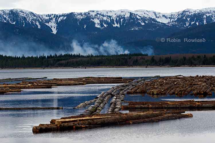
Alberta and British Columbia reach agreement on opening new markets
VANCOUVER – After officials worked through the night, Alberta Premier
Alison Redford and British Columbia Premier Christy Clark today
announced a framework agreement between the two provinces on moving
energy resources to new markets.
“Agreement on B.C.’s 5 conditions is a necessary first step before any
proposals can be considered for approval,” said Premier Christy Clark.
“It is the way we do business in B.C. and it works. By working together
with Alberta through these principles we can grow our economies, and
strengthen Canada’s economy overall.”
The framework will also see the Government of British Columbia endorse
Premier Redford’s Canadian Energy Strategy.
“A key part of our Building Alberta Plan is getting Alberta’s resources
to new markets at much fairer prices so we can keep funding the
programs Albertans told us matter most to them,” said Premier Alison
Redford. “Today’s agreement with B.C. is good news for Alberta, for
British Columbia and for all Canadians. I welcome Premier Clark’s
endorsement of the Canadian Energy Strategy and our shared commitment
to create jobs, long-term growth and position Canada as a true global
energy superpower. We look forward to continued constructive dialogue
with B.C.”
The governments of B.C. and Alberta agree that British Columbia’s
conditions are intended to ensure both the responsible production of
energy as well as its safe transport to new markets, giving projects
the social licence to proceed.
B.C.’s conditions 1-4 are designed to achieve both economic benefit and
risk mitigation on increased shipments through B.C. They mirror
Alberta’s legislated commitments on responsible energy production.
Alberta and B.C. agree that only through intensive environmental review
and protection, enhanced marine safeguards and First Nations support,
can projects proceed.
On condition five, Alberta agrees that B.C. has a right to negotiate
with industry on appropriate economic benefits. Both governments agree
it is not for the governments of Alberta and B.C. to negotiate these
benefits. Both provinces reaffirmed that Alberta’s royalties are not on
the table for negotiation.
Supporters of David Black’s Kitimat Clean project to build a refinery about 25 kilometres north of Kitimat have been met by skepticism by experts and economists from the Canadian oil patch who keep telling the people of northwestern British Columbia that to create jobs by adding value to Alberta crude is uneconomic.
The Americans, apparently, have a different view, with plans announced for shipping projects in Washington State that could handle not only oil shale crude from the Bakken Formation in the Dakotas but also Canadian “heavy crude” aimed at refineries in Californa, refineries that would require new or renovated facilities.
So let’s add another question to northwest BC’s skepticism about the Alberta oil patch. Why is uneconomic to refine in Alberta or BC, but apparently increasingly economic to refine in California given the cost of building or rebuilding facilites?
Opponents of the Northern Gateway pipeline have always speculated that any bitumen exported from Kitimat could end up in California rather than markets in Asia.
According to reports, the Vancouver, Washington, project plans to load the bitumen on barges for shipment to California, which is likely to cause a storm of controversy with environmental groups in both states, especially if a barge, which has almost no controls compared to a tanker, foundered and ended up on the coast. [adsanity id=5199 align=alignright /]
The New York Times, on Oct. 31, looked at the issue in a report Looking for a Way Around Keystone XL, Canadian Oil Hits the Rails. The issue of moving crude by rail has been gaining traction in recent months, with growing opposition to pipeline projects. But where do those long trains of tank cars full of crude go?
Times reporter Clifford Kraus says:
The developing rail links for oil sands range across Canada and over the border from the Gulf Coast to Washington and California. Railways can potentially give Canadian producers a major outlet to oil-hungry China, including from refineries in Washington and California.
According to the Times, the plans call for two Canadian export terminals.
“We want to diversify our markets beyond just moving our product south,” said Peter Symons, a spokesman for Statoil, a Norwegian oil giant that has signed contracts to lease two Canadian oil loading terminals. “We can get that product on a ship and get it to premium markets in Asia.”
The Americans, on the other hand, are looking toward refineries.
Again the Times report says:
Several Washington and Oregon refiners and ports are planning or building rail projects for Canadian heavy crude as well as light oil from North Dakota. The Texas refinery giant Tesoro and the oil services company Savage have announced a joint venture to build a $100 million, 42-acre oil-handling plant in the Port of Vancouver on the Columbia River that could handle 380,000 barrels of oil each day if permits are granted.
Not that everything is clear sailing. The Times says there is resistance to a plan to refine heavy crude in California.
The city of Benicia, Calif., last month delayed the granting of a permit for Valero Energy’s planned rail terminal at its refinery by deciding to require an environmental impact report after residents expressed concerns that Valero would use the terminal to import Canadian oil sands crude.
With access to rail and existing marine infrastructure, the Port of Vancouver is uniquely positioned to serve as a hub for the distribution of North American crude oil to West Coast refining centers. Tesoro and Savage are ideal partners for this project, having already operated in close partnership for almost ten years on the West Coast. The Tesoro-Savage Joint Venture’s combined capabilities, experience and resources are expected to create substantial benefits for the Port and the Vancouver community in the form of sustainable revenue to the Port and local jobs associated with the facility’s construction and operation.
The Tesoro news release quotes Greg Goff, President and CEO of Tesoro.
Building upon the recent success of the rail unloading facility at our Anacortes, Wash., refinery, where we have been delivering Mid-Continent crude oil via unit train in an environmentally sound and cost-effective manner, this project is the ideal next step for Tesoro as we drive additional feedstock cost advantage to the remaining refineries in our West Coast system.
While the Tesoro April release doesn’t specifically mention heavy crude or bitumen from Alberta, in August, Reuters reporting on a Tesoro results conference call said, the project would “supply cheaper U.S. and Canadian crude to refineries all along the West Coast – both its own and those run by competitors.”
The project, which would initially have capacity of 120,000 barrels a day and could be expanded to 280,000 BPD, is the biggest so far proposed to help Pacific Coast refineries tap growing output of inland U.S. and Canadian heavy crudes.
The project, where North Dakota Bakken and Canadian crude would travel by rail to the marine facility in Vancouver, Washington and then barged to refining centers, is being planned with joint venture partner Savage Companies.
The Port of Vancouver facility will have “a lot of flexibility and capability to take different types of crudes, from heavy Canadian crudes to crudes from the Mid-Continent… So we will source crude from where the best place is,” Goff said on Aug. 2. “The facility also was designed to supply the entire West Coast… We can go from as far away as Alaska to Southern California, in those refineries, which we intend to do.”
Reuters also reported
Regulators also are considering Valero’s permit request for a 60,000 bpd rail facility at its 78,000 bpd Wilmington refinery near Los Angeles, but in June the area pollution regulator said it would take 18 months to finish an environmental review, permitting and construction.
Alon Energy USA also is seeking permits for a rail facility at its Southern California refining system, which shut down late last year as losses mounted on high imported crude costs and low asphalt demand. The company hopes to get those permits by year-end.
Valero spokesman Bill Day on Friday declined to say whether Valero would be interested in tapping inland and Canadian crude through the Tesoro project, but noted that the company values flexibility in getting cheaper crudes to its refineries.
Asked today about the New York Times report, (at the time of his regular news conference, he hadn’t read the story) Skeena Bulkley Valley MP Nathan Cullen said, “I mean there’s been so much uncertainty, in large part created by this government with respect to moving oil anywhere. This is another proposal, it seems every week you wake up, open the papers and there’s another proposal. Some of them are legitimate, some of them are snake oil.
“This one I’m not familiar with, so I can’t make specific comments on it, I will certainly look at it because I’m very interested in energy on the west coast. I’d have to see, given the government we have in Ottawa right now, they’re not friends to communities and First Nations and certainly not friends to the oil sector because they keep causing so much concern within the broader public and hurt the companies’ ability to gain social licence to get a project going.”
Screen grab American Petroleum Institute interactive map of LNG export projects. (API)
The American Petroleum Institute, the lobby group for US energy companies has launched an interactive map on its website covering liquefied natural gas export projects.
The API says the U.S. Department of Energy has approved only four applications for permits to export liquefied natural gas nations that don’t have a free trader agreement with the US, adding: “There are currently 21 pending applications, covering 18 discrete facilities where U.S. businesses are seeking to build and operate terminals to process LNG for sales abroad.”
While the map does show proposed projects at Kitimat and Prince Rupert, the “interactivity” does not give details, while there is detailed information on the US projects including “anticipated capital investments, jobs, and export volumes associated with each U.S. site, as well an estimated value of potential exports.”
At least one of the two large liquified natural gas projects in Kitimat is, at least at this point, planning to self-generate the power required using a gas-fired, steam-driven electrical generation system.
The job, which requires 20 years and more experience, would be located in Calgary for eighteen months, then move to Kitimat for the remainder of a four year contract paying from $1650 to $1850 per day.
By Fircroft describing the job as a “mega-project” means that the client is either Shell’s LNG Canada project or the Chevron and Apache KM LNG project, since the much smaller BC LNG project could not be described as a “mega-project.”
As well as the standard qualifications for a senior engineer, the job posting lists:
• Power Plant design, operation and construction experience required.
• Boiler design, construction, operation, and commissioning experience required.
• Heat Recovery Steam Generation (HRSG) design, processes, construction, operation, and commissioning experience required.
• Integrates inherent safety in design and operability in concept selection and development for gas resource opportunities.
Providing the power for the Kitimat and other northwestern LNG projects is becoming controversial. The power is needed to cool the natural gas so it can be loaded onto tankers for shipment to customers.
The BC government recently announced a $650,000 study of the cumulative effect on air quality for the planned industrial expansion in the Kitimat area, including the Rio Tinto Alcan Kitimat modernization project, which would increase the amount of sulphur dioxide emissions, combined with as many as three LNG projects and the associated increase in tanker traffic, as well as the possible and even more controversial Enbridge Northern Gateway project.
At the time of the BC announcement, the Globe and Mail reported:
If natural gas is used either for direct-drive or combined-cycle electricity generation to produce the energy required for the proposed Shell LNG facility at Kitimat, approximately 300 million cubic feet of natural gas would be burned. The proposed Chevron Apache LNG facility could burn approximately 140 million cubic feet of natural gas.
The other alternative for powering the LNG plants is to use hydro-electricity, and BC Hydro at the moment doesn’t have the capacity to supply the LNG projects with power. One possibility is the controversial Site C dam project in the Peace River basin, which is also under review by the BC government.
Although the job is restricted to Canadian citizens or permanent residents, it is clear that the engineer will have to also answer to the project’s overseas partners since one requirement is to conduct: “Overseas VIP workshops, including Value Engineering, Process Simplification, Process Optimization and Design to Capacity.”
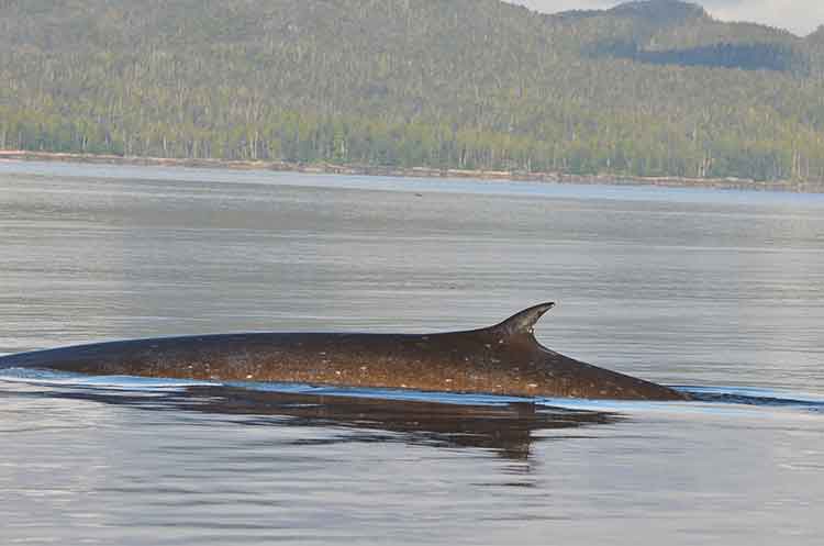
Fin whale in Squally Channel (Courtesy Chris Picard)
Whales are coming back to Douglas Channel.
In 2013, many Kitimat residents with long experience on the water have reported and are still reporting more sightings of both orcas and humpback whales.
Add to this a recently published scientific study that shows the number of humpbacks at the mouth of the channel near Gil Island has doubled in the past decade, with the study saying there were 137 identifiable whales in 2011.
So why are the whales returning? Chris Picard, Science Director for the Gitga’at First Nation and one of the co-authors of the study believes that answer is simple. There are, so far, three species of whales seen in the area, humpbacks, orcas and fin whales. It is only now, Picard believes, that the humpback and fin whale populations are recovering from a century of whaling.
The study estimates there were once about 15,000 humpback whales in the North Pacific when whalers began hunting the animals. That number was down to 1,400 when whale hunting was stopped in Canada in 1966.
As whale numbers increase, they are searching for the rich food sources found in the Channel, both at the mouth around near Gil Island where the study took place and as far north as the Kildala Arm and Clio Bay.
“One of the things the humpbacks like to do when they are on our coast or the Alaskan coast and that is they feed,” Picard said, “So they are really targeting areas that there is a high density of their preferred prey, krill or herring or other schooling fish, sardines in some years.”
So far the study has concentrated in Gitga’at traditional territory around the mouth of Douglas Channel near Gil Island. Picard says increasing the study area to include more of Douglas Channel is a good idea, but would require more resources than are currently available. “We’d like to continue with the study consistent with the work that we have been doing. Considering what we’re seeing in the local Douglas Channel area, Wright Sound, Gil Island, it can be very worthwhile.
“We are going to continue with our current study which involve getting to know how many humpbacks are using the area and continue with the study that we just published to see if numbers continue to increase or to see whether or if they do start to stabilize at some number,” Picard said. “With more and more proposals for increased shipping, we get to see any changes with humpback numbers that may be linked to increased shipping. We’ll continue to monitor the humpback population; not just their numbers but also their distribution in the area. We’ll continue to monitor that, again in relation to the various shipping proposals and activities that are proposed.”
It was during that study on humpbacks that the researchers from the Gitga’at Nation and the Cetacean Lab noticed the appearance of fin whales, another species that had been hit hard by whaling. (“We’ve worked very closely with the Cetacean Lab group and frankly without their help we would never have published any of this work because their data certainly was instrumental in getting the overall data set that made possible a publishable study,” Picard said.)
“We have observed is that fin whales have increased in their abundance in the area quite a bit, “ Picard said. “I can remember when we first started doing surveys, there were not too many. We’ve gone from seeing a couple over the course of an entire year. Now when we do our marine mammal surveys in the area the fin whales you pretty much see in every survey and in more and more numbers. So it’s quite encouraging to see that fin whales are becoming more abundent in the area. They were also hunted, so if you factor in the days of commercial whaling operations, that of course has stopped, so its encouraging to see that their numbers are coming back too.
The fin whales tend to be found in many of the same areas at the humpack whales are using, Caamaño Sound, Campania Sound and areas south of Gil Island. “we’ve also seen them more in the interior waters like Squally Channel, Wright Sound, Whale Channel, similar to the areas where we see the humpbacks.
“We haven’t done the same level of detailed analysis on the fin whale distribution as we have with the humpback, so it’s just my overall impression that they’re using similar habitats.
“It’s unique for fin whales to be using these more confined waters. It is my understanding that they are more of an open water species. I think that makes the area fairly unique,” he said.
Picard added it would be interesting to do a historic study to see how many fin whales were taken by whalers in the previous decades, especially in Caamaño Sound, Squally Channel and Wright Sound.
“The fact that we saw so many humpbacks relative to the size of the area, which is pretty small relative to the whole coast, so there must be a high abundance of food in the area,” Picard said.
“I’d like to get a better understanding of what is really driving the food abundance in the area. What is the oceanography in the area, what are the currents, what is driving that high area of biological activity that the whales seeming to be homing in on.”
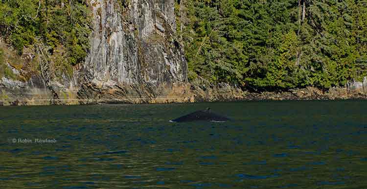
Humpback whale in the Kildala Arm, September 14, 2013. (Robin Rowland)
That means, Picard believes, that there could be krill and juvenile herring schooling in the upper Douglas Channel and that is what is attracting the whales.
One of the next steps, Picard said, is to study social interaction among whales. “We do take identification photographs, so we get a sense of who’s hanging out with who; who is bringing their calves into the area to introduce them into what seems to be very good whale habitat,” Picard.
So one aim of a future study would be to se what role social interactions play in the increased whale sightings in the Douglas Channel. He also wants to know what role are the potential negative impacts on that whale social interaction comes noise impacts, or being struck by ships, and the potential environmental affects of oil spills. “So do these social interactions decrease as the impacts increase, does that mean there are going to be fewer whales that come into this area? Those are some of the questions we want to address.”
Carrie Mishima, a communications advisor for the Department of Fisheries and Oceans sent this statement in response to questions from Northwest Coast Energy News:
· The proposal by the Kitimat LNG project uses a relatively new technique that is expected to improve aquatic habitat in Clio Bay. The bay has been used as a log handling site for decades, resulting in areas of degraded habitat from woody debris on the seafloor. The project will cap impacted areas with inert material to restore the seafloor.
· Capping at smaller-scale sites in Canada has shown that the technique has successfully restored low-value aquatic habitat.
· The project will implement standard and project-specific measures to protect fish and aquatic habitat and will conduct a five-year monitoring program to determine how well the habitat is recovering.
· Data from the monitoring program will be used to guide future habitat reclamation at impacted habitat sites. Reference sites are being established as benchmarks against which the capped sites can be measured.
· Site-specific standards for dissolved oxygen levels will be developed for the enhanced site by sampling a control site having similar habitat parameters.
· Detailed mapping has been done to identify the best areas for the soil placement and to protect sensitive habitat such as intertidal areas, rocky substrates and eelgrass beds.
· Other required mitigation measures will include analyzing the cap material to confirm it is free of contaminants and placing this material during appropriate tidal conditions to ensure accurate placement of the cap in accordance with design plans.
A job for a “construction area superintendent” for both the Kitimat LNG plant and the Clio Bay restoration appeared on job sites in the world wide web on October 1. The posting expires on December 31.
The job was originally posted by Brunel Energy, a consulting firm that describes itself as a company that “provides specialist personnel to the international oil & gas, petrochemical, power generation and construction industries.”
The contract job, which, requires 20 years experience and will pay between $1,500 and $2,500 a day, calls for someone who would be “developing project level execution plans for EW&I, LNG Plant & Clio Bay restoration program, and implement/control against these plans in accordance with Project Management System (PMS) processes, procedures and standards.” That superintendent will eventually turn over “functioning facilities to LNG Plant or operations staff.”
As well as standard requirements for a giant construction job of this nature, the requirements include:
• Represent the Company in all interfaces with BC and Kitimat agency associated with EW&I construction activity. Maintaining a positive relationship with the agency by conforming to all regulations and resolving areas of uncertainty in a mutually agreeable manner.
• Maintaining positive relations with the First Nations Haisla representative, recognizing them as a partner and owner of the overall Kitimat LNG Project Development.
Chevron and Apache are partners in the development of the KM LNG project at Bish Cove.
Special report: Clio Bay cleanup: Controversial, complicated and costly
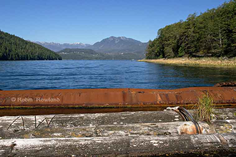
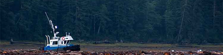
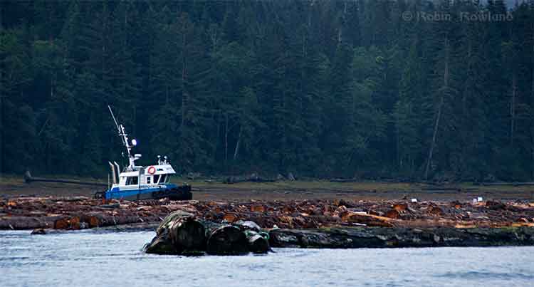
Log booming operations at Clio Bay, August 21, 2013. (Robin Rowland/Northwest Coast Energy News)
Chevron, the company operating the KM LNG project at Bish Cove and the Haisla Nation have proposed that marine clay from the Bish Cove construction site be used to cap more than 10,000 sunken and rotting logs in Clio Bay. Haisla Chief Counsellor Ellis Ross says he hopes that using clay to cover the logs will help remediate the environmentally degrading sections of the Bay. The proposal has brought heated controversy over the plan, both among residents of Kitimat and some members of the Haisla Nation, who say that Clio Bay is full of life and that the capping will cause irreparable damage.
An investigation by Northwest Coast Energy News shows that capping thousands of sunken logs is a lot more complicated and possibly costly than anyone has considered. It is also clear that many of the comments both supporting and opposing the Clio Bay project are based on guesses rather than the extensive scientific literature available on the subject.
Northwest Coast Energy News findings include:
In 1997, the Department of Fisheries and Oceans surveyed sunken log sites in Douglas Channel. The results, published in 2000, identified 52 sites just on Douglas Channel and the Gardner Canal that had various levels of enviromental degradation due to sunken logs. Clio Bay was not the list. The DFO scientists recomended followup studies that never happened.
Scientific studies show that degradation from sunken logs can vary greatly, even within one body of water, due to depth, currents, number of logs, and other factors. So one part of a bay can be vibrant and another part environmentally degraded due to low levels of dissolved oxygen and decaying organic material.
If KM LNG wasn’t paying for the remediation of Clio Bay, it could be very expensive. Capping sunken logs at a cove near Ketchikan, Alaska, that is the same size and shape as Clio Bay cost the US and Alaska governments and the companies involved $2,563,506 in 2000 US dollars. The total cost of the cleanup of the site which was also contaminated with pulp mill effluent was $3,964,000. The estimated cost of capping the logs in the Alaska project was $110 per cubic yard.
The Alaska project shows that a remediation project means while most of the logs in a bay or cove can be capped, in some parts of a water body, depending on currents, contamination and planned future use, the logs have to be removed and the area dredged.
Agencies such as the State of Alaska, the US Environmental Protection Agency and the US Army Corps of Engineers all recommend using “clean sand” for capping operations. Although “clay balls” have been used for capping in some cases, the US officials contacted say they had no record of large amounts of marine clay ever being used for capping. They also noted that every log capping project they were aware of happened in sites that had other forms of contamination such as pulp mill effluent.
Chevron only recently retained the environmental consulting firm Stantec to study Clio Bay. The Department of Fisheries and Oceans has told District of Kitimat Council it recently completed mapping of the seafloor at Clio Bay. The Alaska project was preceded by five years of monitoring and studies before capping and cleanup began.
A letter from Fisheries and Oceans to the District of Kitimat says that Clio Bay has been mapped and the department is planning to monitor any capping operations. However, it appears from the Department of Fisheries and Oceans website that the department has no current policies on remediation since the Conservative government passed two omnibus which weakened the country’s environmental laws. According to the website, new remediation policies are now being drafted. That means that although DFO will be monitoring the Clio Bay operation, it is uncertain what standards DFO will be using to supervise whatever happens in Clio Bay.
Northwest Coast Energy News is continuing its investigation of the sunken logs problem. Expect more stories in the days to come.
Special report: Clio Bay cleanup: Controversial, complicated and costly
Clio Bay, looking toward Douglas Channel, September 14, 2013. (Robin Rowland/Northwest Coast Energy News)
Haisla First Nation Chief Counsellor Ellis Ross says the Haisla made the proposal to the KM LNG project, a partnership of Chevron and Apache, to use the marine clay to cover the thousands of logs at the bottom of Clio Bay after years frustration with the Department of Fisheries and Oceans and the BC provincial government, which for decades ignored requests for help in restoring almost fifty sunken log sites in Haisla traditional territory.
The problem is that remediation of the hundreds of sites on Canada’s west coast most containing tens of thousands of sunken logs has been so low on DFO’s priority list that even before the omnibus bills that gutted environmental protection in Canada, remediation of sunken log sites by DFO could be called no priority.
Now that the KM LNG has to depose of a total of about 3.5 million cubic metres of marine clay and possibly other materials from the Bish Cove site, suddenly log remediation went to high priority at DFO.
The controversy is rooted in the fact that although the leaders of the Haisla and the executives at Chevron knew about the idea of capping Clio Bay, people in the region, both many residents of Kitimat and some members of the Haisla were surprised when the project was announced in the latest KM LNG newsletter distributed to homes in the valley.
Chevron statement
In a statement sent to Northwest Coast Energy News Chevron spokesperson Gillian Robinson Ridell said:
The Clio Bay Restoration Project proposed by Chevron, is planned to get underway sometime in early 2014. The proposal is fully supported by the Federal Department of Fisheries and Oceans and the Haisla First Nation Council. The project has been put forward as the best option for removal of the marine clay that is being excavated from the Kitimat LNG site at Bish Cove. Chevron hired Stantec, an independent engineering and environmental consulting firm with extensive experience in many major habitat restoration projects that involve public safety and environmental conservation. The Haisla, along with Stantec’s local marine biologists, identified Clio Bay as a site that has undergone significant environmental degradation over years of accumulation of underwater wood debris caused by historic log-booming operations. The proposal put forward by the marine biologists was that restoration of the marine ecosystem in the Bay could be achieved if marine clay from Chevron’s facility site, was used to cover the woody debris at the bottom of the Bay. The process outlined by the project proposal is designed to restore the Clio Bay seafloor to its original soft substrate that could sustain a recovery of biological diversity.
Kitimat worried
Non-aboriginal residents of Kitimat are increasingly worried about being cut off from both Douglas Channel and the terrestrial back country by industrial development. These fears have been heightened by reports that say that Clio Bay could be closed to the public for “safety reasons” for as much as 16 months during the restoration project.
The fact that Clio is known both as a safe anchorage during bad weather and an easy to get to location for day trips from Kitimat has made those worries even more critical.
There is also a strong feeling in Kitimat that the residents were kept out of the loop when it came to the Clio Bay proposal.
In a letter to the District of Kitimat, DFO said:
Clio Bay has been used as a log handling site for decades which has resulted in areas of degraded habitat from accumulations of woody debris materials on the sea floor. The project intends to cap impacted areas with inert materials and restore soft substrate seafloor. The remediation of the seafloor is predicted to enhance natural biodiversity and improve the productivity of the local fishery for Dungeness crab. The project area does support a variety of life that will be impact and therefore the project will require authorization from Fisheries and Oceans Canada for the Harmful Alteration, Disruption or Destruction (HADD) of fish and fish habitat.
The letter avoids the controversy over the use of marine clay but saying “inert material” will be used. That can only increase the worries from residents who say that not only clay but sand, gravel and other overburden from Bish Cove and the upgrade of the Forest Service Road may be used in Clio Bay. (The use of “inert material” also gives DFO an out if it turns out the department concludes the usual practice of using sand is better. That, of course, leaves the question of what to do with the clay).
Although Ellis Ross has said he wants to see large numbers of halibut and cod return to Clio Bay, the DFO letter only mentions the Dungeness Crab.
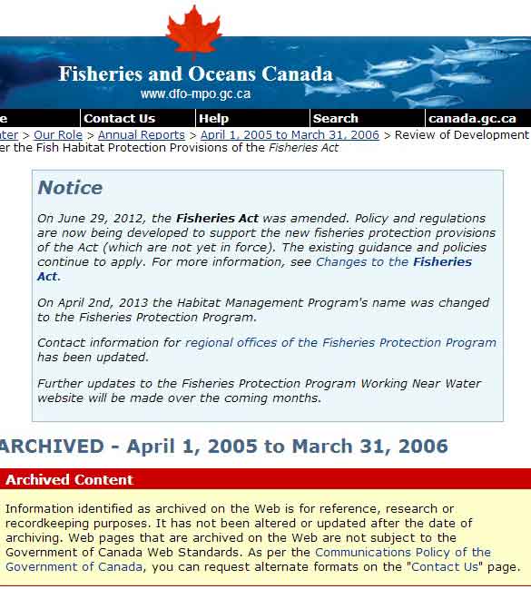
DFO website cites pending changes after the passage of the omnibus bills.
Try to search “remediation” on the DFO site and the viewer is redirected to a page that cites the omnibus bills passed by the Conservative government and says
On June 29, 2012, the Fisheries Act was amended. Policy and regulations are now being developed to support the new fisheries protection provisions of the Act (which are not yet in force). The existing guidance and policies continue to apply. For more information, see Changes to the Fisheries Act.
On April 2nd, 2013 the Habitat Management Program’s name was changed to the Fisheries Protection Program.
So, despite what communications officers for DFO and the Harper government may say, there was no policy then and there is no policy now on remediation of log sites. Given Harper’s attitude that LNG and possibly bitumen export must proceed quickly with no environmental barriers, it is likely that environmental remediation will continue to be no priority—unless remediation becomes a problem that the energy giants have to solve and pay for.
Alaska studies
On the other hand, the State of Alaska and the United States Environmental Protection Agency spent a decade at a site near Ketchikan studying the environmental problems related to sunken logs at transfer sites
Those studies led Alaska to issue guidelines in 2002 with recommended practices for rehabilitating ocean log dump sites and for the studies that should precede any remediation project.
The Alaska studies also show that in Pacific northwest coast areas, the ecological effects of decades of log dumping, either accidental or deliberate, vary greatly depending on the topography of the region, the topography of the seabed, flow of rivers and currents as well as industrial uses along the shoreline.
The Alaska policy is based on studies and a remediation project at Ward Cove, which in many ways resembles Clio Bay, not far from Kitimat, near Ketchikan.
The Alaska policy follows guidelines from both the US Environmental Protection Agency and the US Army Corps of Engineers that recommend using thin layers of “clean sand” as the best practice method for capping contaminated sites. (The Army Corps of Engineers guidelines say that “clay balls” can be used to cap contaminated sites under some conditions. Both a spokesperson for the Corps of Engineers and officials at the Alaska Department of Environmental Conservation told Northwest Coast Energy News that they have no records or research on using marine clay on a large scale to cap a site.)
The EPA actually chose Sechelt, BC, based Construction Aggregates to provide the fine sand for the Ward Cove remediation project. The sand was loaded onto 10,000 tonne deck barges, hauled up the coast to Ward Cove, offloaded and stockpiled then transferred to derrick barges and carefully deposited on the sea bottom using modified clam shell buckets.
The EPA says
Nearly 25,000 tons of sand were placed at the Ward Cove site to cap about 27 acres of contaminated sediments and 3 other acres. In addition, about 3 acres of contaminated sediments were dredged in front of the main dock facility and 1 acre was dredged near the northeast corner of the cove. An additional 50 acres of contaminated sediments have been left to recover naturally.
A report by Integral Consulting, one of the firms involved at the project estimated that 17,800 cubic metres of sand were used at Ward Cove.
In contrast, to 17,800 cubic metres of sand used at Ward Cove, the Bish Cove project must dispose of about 1.2 million cubic metres of marine clay at sea (with another 1.2 million cubic metres slated for deposit in old quarries near Bees Creek).
Studies at Ward Cove began as far back as 1975. In 1990 Alaska placed Ward Cove on a list of “water-quality limited sites.” The studies intensified in 1995 after the main polluter of Ward Cove, the Ketchikan Paper Company, agreed in a consent degree on a remediation plan with the Environmental Protection Agency in 1995. After almost five years of intensive studies of the cove, the sand-capping and other remediation operations were conducted from November 2000 to March 2001. A major post-remediation study was carried out at Ward Cove in 2004 and again in 2009. The next one is slated for 2015.
Deaf ears at DFO
“We need to put pressure on the province or Canada to cleanup these sites. We’ve been trying to do this for the last 30 years. We got nowhere,” Ellis Ross says. “Before when we talked [to DFO] about getting those logs and cables cleaned up, it fell on deaf ears. They had no policy and no authority to hold these companies accountable. So we’re stuck, we’re stuck between a rock and hard place. How do we fix it?”
Ross says there has been one small pilot project using marine clay for capping which the Haisla’s advisers and Chevron believe can be scaled up for Clio Bay.
Douglas Channel studies
The one area around Kitimat that has been studied on a regular basis is Minette Bay. The first study occurred in 1951, before Alcan built the smelter and was used as a benchmark in future studies. In 1995 and 1996, DFO studied Minette Bay and came to the conclusion that because the water there was so stagnant, log dumping there had not contributed to low levels of dissolved oxygen although it said that it could not rule out “other deleterious effects on water quality and habitat`from log dumping.”
That DFO report also says that there were complaints about log dumping at Minette Bay as far back as 1975, which would tend to confirm what Ross says, that the Haisla have been complaining about environmentally degrading practices for about 30 years.
Ross told Northwest Coast Energy News that if the Clio Bay remediation project is successful, the next place for remediation should be Minette Bay.
A year after the Minette Bay study, DFO did a preliminary study of log transfer sites in Douglas Channel, with an aerial survey in March 1997 and on water studies in 1998. The DFO survey identified 52 locations with sunken logs on Douglas Channel as “potential study sites.” That list does not include Clio Bay. On water studies were done at the Dala River dump site at the head of the inlet on Kildala Arm, Weewanie Hotsprings, at the southwest corner of the cove, the Ochwe Bay log dump where the Paril River estuary opens into the Gardner Canal and the Collins Bay log dump also on the Gardner Canal.
In the introduction to its report, published in 2000, the DFO authors noted “the cumulative effect of several hundred sites located on BC coast is currently unknown.”
Since there appears to have been no significant follow-up, that cumulative effect is still “unknown.”
In 2000 and 2001, Chris Picard, then with the University of Victoria, now Science Director for the Gitga’at First Nation did a comparison survey of Clio Bay and Eagle Bay under special funding for a “Coasts Under Stress” project funded by the federal government. Picard’s study found that Eagle Bay, where there had been no log dumping was in much better shape than Clio Bay. For example, Picard’s study says that “Dungeness crabs were observed five times more often in the unimpacted Clio Bay.”
Although low oxygen levels have been cited as a reason for capping Clio Bay, Picard’s study says that “near surface” oxygen levels “did not reliably distinguish Clio and Eagle Bay sediments.” While Clio Bay did show consistent low oxygen levels, Eagle Bay showed “considerable interseasonal variation” which is consistent with the much more intensive and ongoing studies of oxygen levels at Wards Cove.
Chevron’s surprise
It appears that Chevron was taken by surprise by the controversy over the Clio Bay restoration. Multiple sources at the District of the Kitimat have told Northwest Coast Energy News that in meetings with Chevron, the company officials seemed to be scrambling to find out more about Clio Bay.
This is borne out by the fact, in its communications with Northwest Coast Energy News, Chevron says its consulting firm, Stantec has cited just two studies, Chris Picard’s survey of Clio Bay and a 1991 overview of log-booming practices on the US and Canadian Pacfic coasts. So far, Chevron has not cited the more up-to-date and detailed studies of Ward Cove that were conducted from 1995 to 2005.
Chevron says that Stantec marine biologists are now conducting extensive field work using divers and Remote Operated Vehicle surveys to “observe and record all flora and fauna in the bay and its levels of abundance. Stantec’s observations echoed the previous studies which determined that the massive amount of wood has harmed Clio Bay’s habitat and ecosystem.”
In its statement to Northwest Coast Energy News, Chevron cited its work on Barrow Island, in Western Australia, where the Chevron Gordon LNG project is on the same island as a highly sensitive ecological reserve.Chevron says the Australian site was chosen only after a thorough assessment of the viability of other potential locations, and after the implementation of extensive mitigation measures, including a vigorous quarantine program for all equipment and materials brought on to the Barrow island site to prevent the introduction of potentially harmful alien species.
Reports in the Australian media seem to bare out Chevron’s position on environmental responsibility. Things seem to be working at Barrow Island.
Robinson went on to say:
Those same high environmental standards are being applied to the Kitimat LNG project and the proposed Clio Bay Restoration project. The proposed work would be carried out with a stringent DFO approved operational plan in place and would be overseen by qualified environmental specialists on-site.
The question that everyone in the Kitimat region must now ask is just how qualified are the environmental specialists hired by Chevron and given staff and budget cuts and pressure from the Prime Minister’s Office to downgrade environmental monitoring just how stringent will DFO be monitoring the Clio Bay remediation?
Alaska standardsIn the absence of comprehensive Canadian studies, the only benchmark available is that set by Alaska which calls for:Capping material, typically a clean sand, or silty to gravelly sand, is placed on top of problem sediments. The type of capping material that is appropriate is usually determined during the design phase of the project after a remediation technology has been selected. Capping material is usually brought to the site by barge and put in place using a variety of methods, depending on the selected remedial action alternative.
Thick Capping
Thick capping usually requires the placement of 18 to 36 inches of sand over the area. The goal of thick capping is to isolate the bark and wood debris and recreate benthic habitat that diverse benthic infauna would inhabit.
Thin Capping
Thin capping requires the placement of approximately 6 – 12 inches of sand on the project area. It is intended to enhance the bottom environment by creating new mini-environments, not necessarily to isolate the bark and wood debris. With thin capping, surface coverage is expected to vary spatially, providing variable areas of capped surface and amended surface sediment (where mixing between capping material and problem sediment occurs) as well as limited areas where no cap is evident.
Mounding
Mounding places small piles of sand or gravel dispersed over the waste material to create habitat that can be colonized by organisms. Mounding can be used where the substrate will not support capping.
Special report: Clio Bay cleanup: Controversial, complicated and costly
Log booming operations at Clio Bay, August 21, 2013 (Robin Rowland/Northwest Coast Energy News)
Updated October 3, 2013, with DFO statement
One of the major concerns about Clio Bay is the possible lack of oxygen to support sealife. While some people have called Clio Bay “dead,” others have pointed to catches of crab, cod and salmon to dispute that.
The experience at Ward Cove, Alaska, even though it was more polluted than Clio Bay, shows that oxygen levels are highly variable, depending on season, location and depth.
In 1995, the DFO`s Institute of Ocean Siences studied dissolved oxygen levels in Minette Bay, and concluded, according to a report posted on the DFO website, that because Minette Bay was stagnant from May to November” and those conditions existed even before industrial development in the Kitimat Valley:
Examination of all the dissolved oxygen data showed that conditions before or early in the industrial development of the region were not significantly different from those observed in the 1995 to 1996 study. On the basis of these analyses we concluded that log storage and handling activities in the bay do not appear to have exacerbated the naturally occurring low dissolved oxygen conditions.
Ward Cove
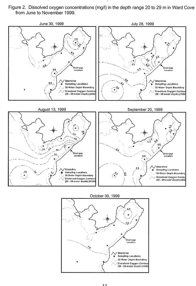
The US Enviromental Protection Agency studied disolved oxygen levels at Ward Cove during water quality monitoring from 1998 to 2002. The monitoring found that dissolved oxygen levels of less than 4 milligrams per litre commonly occurred in Ward Cove during the summer and early fall. “During this time, hypoxic conditions (dissolved oxygen less than 2 milliggrams per litre) occurred occasionally at and near the bottom and less frequently in midwater areas. Hypoxia can be dangerous to both fish and bottom dwelling species.”
The EPA study showed that water circulation is restricted within Ward cove. A counter-clockwise circulation brings ocean water from Tongass Narrow into the cove along the south shore. That water usually exits after 15 days.
The EPA studied dissolved oxygen in Ward Cove from November 1995 to October 2002, using 13 monitoring stations, nine inside the cove and four outside in Tongass Narrows.
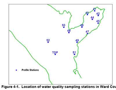
Map of water quality sampling stations in Ward Cove, Alaska (EPA)
This monitoring found that the water column is strongly stratified during the summer resulting in poor mixing of bottom water. The EPA says during the monitoring period:
dissolved oxygen levels between 2 and 4 mg/1 were commonly observed in Ward Cove. These conditions began at water depths greater than approximately 20 metres in mid to late July and continued until early October, but oxygen levels between 2 and 4 mg/1 may also occur in water as shallow as 15 metres.
The EPA says the normal oxygen level for the surface waters of Ward Cove is approximately 8 mg/1 at 10°C. Under natural conditions and vertical stratification, dissolved oxygen levels in deeper waters can vary considerably and be reduced significantly below 8 mg/1 by respiration and the decay of organic materials, including sunken logs.
Since Clio Bay is deeper than Ward Cove, that means dissolved oxygen levels could be decreased at the greater depths.
Maps showing differing levels of dissolved oxygen during monitoring at Ward Cove. Alaska (EPA)
Salmon
The Ward Cove study also confirmed laboratory studies that showed that salmon can detect and avoid areas of low oxygen. Coho, pink, sockeye, chum, steelhead, Dolly Varden and Cutthroat trout are all native to the cove. Introduced Chinook are also found at Wards Cove.
A Ward Cove report says:
Depressed dissolved oxygen conditions are unlikely to significantly affect the growth of juvenile or adult salmonids migrating through or feeding in or near Ward Cove. Some minor indirect effects, however, may occur as a result of hypoxia-induced changes to food chain organisms inhabiting the cove and adjacent waters.
The growth cycles of the adult stage of all seven anadromous salmon and trout species native to Ward Creek should be completed prior to their arrival in the cove from the ocean. Some feeding by adult cutthroat trout and Dolly Varden may occur in or near the cove as they hold in preparation for entering Ward Creek. The growth of subadult chinook salmon, a fish species not native to Ward Creek, is also not likely affected by exposures to these conditions.
Returning adult salmonids may be present in the cove when the lowest dissolved oxygen and highest water temperatures occur in late summer and early fall. Adult salmonids will usually avoid hypoxic conditions, except when staging to enter freshwater during the latter part of their annual spawning migrations. Severe depressed DO levels at this time in combination with low flows and high water temperatures in Ward Creek can result in adult mortality. Fish kills have not been observed recently in the cove, likely because the depressed DO conditions have not extended into a greater portion of the water column in combination with low flows in Ward Creek.
As for other species, the report says reaction varies, with species that are able to swim often leaving areas of depressed oxygen. Previous studies have shown that bottom dwelling species may be able to tolerate low oxygen for a short time and become susceptible if they don’t swim out of the area. Those species who are are not mobile, have weak swimming abilities, or live within the sediment are more likely to be susceptible.
That means that changes in oxygen level could mean that deaths or migration of mobile bottom dwelling species at a location, leaving the impression that species are no longer around, even though the changes may be seasonal. Scientific studies show that low oxygen levels can also make all species in that area vulnerable to disease due to stress. Low oxygen also limits swimming ability and makes a species more prone to predation.
Minette Bay
Log boom at Minette Bay. April 14, 2013. (Robin Rowland/Northwest Coast Energy News)
From August 1995 until October 1996, the Department of Fisheries and Oceans (Institute of Ocean Sciences and the North Coast Division of Habitat Management) with the support local companies studied the water quality in Minette Bay.
A 1961 study of oceanography of the BC fjords and a second study of in 1968 had already reported finding low dissolved oxygen levels in Minette Bay.
As far back as 1975, the report says:
Concerns have been raised that the poor water quality of the bay is exacerbated if not caused directly by the log handling practices there. Other habitat disruptions have been attributed to the industrial activities associated with log handling practices in this bay, e.g. bottom scouring, bark litter, and sinkers.
The DFO report says that the purpose of our study of Minette Bay was to determine if log handling in the bay “significantly contributed to low dissolved oxygen concentrations.”
The study of Minette Bay was similar to the one then starting at Ward Cove, but on a much smaller scale, checking salinity, temperature and levels of dissolved oxygen.
The report says:
The renewal of Minette Bay deep waters occurs annually during the winter and early spring months. Renewal occurs in the form of multiple events, some of which penetrate to the bottom while others only affect the intermediate waters. These events are caused by the outbreaks of the Arctic air mass over the region. The cold air temperatures reduce run-off thereby increasing surface salinity while at the same time the strong outflow winds push the surface layer away from the head of Kitimat Arm and bring denser water closer to the surface. The cold outflow winds also cool and mix the surface waters. In the stagnant period from May to November, dissolved oxygen concentrations in the deep waters decline rapidly to near zero conditions by July and remain low until the late fall.
The 1995 study concluded, based on surveys and reports from the previous 45 years, that measurements of dissolved oxygen in 1951 before the Alcan smelter was built, through measurements in the 1960, were not different from the 1995 measurements in the deep waters.`and concluded “that log handling practices in the bay have not exacerbated the naturally occurring low DO conditions in the bay.”
`
It goes on to say while log storage and handling at Minette Bay had no apparent effect on dissolved oxygen:
other deleterious effects on water quality and habitat are possible. These impacts might include: the disruption of animal and plant ‘life on and in the sediments by the grounding of log booms or scouring of the bottom sediments by the movement of log booms; the alteration of the natural composition of the sediments and the benthic community by the accumulation of bark, whole logs and other wood debris on the sediments underneath the log storage areas and in the log dump zone; anoxia in sediments due to an increased organic load; and toxic concentrations of leachates from the logs and other wood debris.
It called for further studies of Minette Bay such as using an underwater camera, could provide a cost effective way to visually inspect and classify the bottom sediments. Those sediments could then be sampled
based on the preliminary mapping of sediment characteristics, log handling impacts and visual ·surveys. At these locations the benthic community should be sampled for diversity and species composition. This information by itself or in conjunction with historical surveys in the bay and Kitimat Arm may give a sense of the degree of impact that log handling operations are having on the ecology of Minette Bay.
It also called for studies for “two small inlets that have very shallow sills; Foch Lagoon which has a 4 metre deep sill at low water and the other is Kiskosh Inlet which has a 2 metre deep sill.”
It notes
Kiskosh Inlet has a maximum depth of about 53m and is more like Minette Bay than Foch Lagoon which has a much deeper basin (250m). Their very shallow sills suggest that the deep basin waters in these two inlets may be oxygen depleted. A comparison with Minette Bay may be instructive as there are no log storage or handling activities in either of these inlets.
In 1997, DFO created a list of 52 sites on Douglas Channel that were used as active, abandoned or potential log dump sites, as targets for studies. The east and west sides of Minette Bay were two items on the list. Clio Bay, Foch Lagoon and Kiskosh Inlet were not on that list.
Haisla Chief Counsellor Ellis Ross says that if the Clio Bay capping project works, Minette Bay should be next.
Dissolved oxygen standards
The state of Alaska has set standards for dissolved oxygen in marine water with a minimum of six milligrams per litre in the one metre surface layer for coastal water and 5 milligrams per litre in estuaries, “except where natural conditions cause this value to be depressed,” with an additional standard of a minimum of 4 milligrams per litre at any one point in both coastal waters and estuaries.
In a statement to Northwest Coast Energy News, DFO spokesperson Carrie Mishima said, “Site-specific standards for dissolved oxygen levels will be developed for the enhanced site by sampling a control site having similar habitat parameters.”
It appears from documents posted on the DFO website that dissolved oxygen monitoring has been dismissed by DFO as too expensive until the issue became important to fish farming.
A 2005 DFO report on the Bay of Fundy noted
The time has therefore arrived for Canada to proceed seriously and rapidly toward the development and implementation of adequate dissolved oxygen standards and management protocols for the marine coastal zone and aquaculture. Such an effort will enable us to avoid the serious eco-socio-economic consequences associated with poor water quality. From a risk analyses perspective the dissolved oxygen issue might be classified as manageable. Aquaculture takes place in a relatively small proportion of the Canadian coastline and it is only within some of these areas that aquaculture is intense enough to pose potential problems. Hence, the likelihood of a major aquaculture induced depletion of dissolved oxygen is probably low to moderate and the impact of reductions is also probably low to moderate.
Another 2005 DFO report, again on aquaculture, based on meetings in Ottawa noted:
Dissolved oxygen is not yet an easily applied regulatory tool on a specific case-by-case basis, and views were mixed regarding its promise as a candidate for monitoring environmental quality in the coastal zone. However, it is one of the few options available for monitoring over hard bottoms. It is also a useful tool for predicting and assessing far-field effects in environments where oxygen levels may be a concern.
This despite the fact that Alaska and the EPA had been monitoring dissolved oxygen and setting standards for the previous decade.
Canada does not yet have national standards for dissolved oxygen levels in coastal waters. DFO says “site specific” standards will be applied at Clio Bay, but so far there are no details of what those standards will be.