Clio Bay: Chevron statement

Chevron LogoSpecial report: Clio Bay cleanup: Controversial, complicated and costly

Here is the text of a statement Chevron spokesperson Gillian Robinson Riddell sent to Northwest Coast Energy News

The Clio Bay Restoration Project proposed by Chevron, is planned to get underway sometime in early 2014. The proposal is fully supported by the Federal Department of Fisheries and Oceans and the Haisla First Nation Council. The project has been put forward as the best option for removal of the marine clay that is being excavated from the Kitimat LNG site at Bish Cove. Chevron hired Stantec, an independent engineering and environmental consulting firm with extensive experience in many major habitat restoration projects that involve public safety and environmental conservation. The Haisla, along with Stantec’s local marine biologists, identified Clio Bay as a site that has undergone significant environmental degradation over years of accumulation of underwater wood debris caused by historic log-booming operations. The proposal put forward by the marine biologists was that restoration of the marine ecosystem in the Bay could be achieved if marine clay from Chevron’s facility site, was used to cover the woody debris at the bottom of the Bay. The process outlined by the project proposal is designed to restore the Clio Bay seafloor to its original soft substrate that could sustain a recovery of biological diversity.

In preparing this restoration project proposal for Chevron, Stantec conducted independent field studies carried out by their own marine biologists who are registered with BC College of Applied Biology. Two of the studies used in the development of the proposed project were previously published scientific studies on the effects of log-boom activity and log boom activity in Clio Bay that determined log boom and storage activity has had a negative impact on marine diversity. There are previous case studies where capping activity has been used in marine environments.

Stantec’s, and previous studies, have determined that Clio Bay has changed from a once highly productive marine bay characterized by plentiful predatory species such as Dungeness Crab and sunflower stars to a less productive environment hosting more opportunistic and resilient species such as squat lobster and sea anemones. One such study found that compared to Eagle Bay, which has not been affected by logging activity had five times the Dungeness Crab population of Clio Bay. Independent studies conducted before Chevron began working at Bish Cove found that if Clio Bay is left in its current degraded condition, the woody debris will continue to foster and abnormal, species-deficient habitat for several decades. Extensive fieldwork carried out by Stantec’s marine biologists used SCUBA and Remote Operated Vehicle surveys to observe and record all flora and fauna in the bay and its levels of abundance. Stantec’s observations echoed the previous studies which determined that the massive amount of wood has harmed Clio Bay’s habitat and ecosystem.

Most importantly, when considering the work Chevron is proposing to carry out in Clio Bay, it is important to note that a primary objective of all Chevron’s operations is to protect people and the environment. A good example of how we have done that on other projects can be seen in the construction of Chevron’s Gorgon LNG plant in Australia on Barrow Island, which is a Class A nature reserve. Although identified as one of the most important wildlife refuges in the world, and the site was chosen only after a thorough assessment of the viability of other potential locations, and after the implementation of extensive mitigation measures, including a vigorous quarantine program for all equipment and materials brought on to the Barrow island site to prevent the introduction of potentially harmful alien species. Those same high environmental standards are being applied to the Kitimat LNG project and the proposed Clio Bay Restoration project. The proposed work would be carried out with a stringent DFO approved operational plan in place and would be overseen by qualified environmental specialists on-site.

[rps-include post=5057]

Clio Bay Editorial:Hire the experts. This is not the time to be learning on the job

Special report: Clio Bay cleanup: Controversial, complicated and costly

Editorial:

Hire the experts. This is not the time to be learning on the job.

Everyone in the Kitimat and Kitamaat Village are facing a dilemma, a dilemma that should have been solved a year ago, when it was first known that the KM LNG project at Bish Cove had grossly underestimated the amount of marine clay and other material that has to be removed for the liquified natural gas terminal, a total of about 3.5 million metric tonnes.

The Haisla and Chevron are proposing that much of the clay be deposited over sunken logs in Clio Bay.

Chevron, which only took over operations at KM LNG in December 2012, is still learning on the job.

When the Clio Bay capping plan became public, far too late in the process, only then did Chevron begin to take a serious look public worries about the environmental problems that might result from depositing all that marine clay in Clio Bay.

Chevron hired Stantec, a well-known international  consulting firm with close ties to the energy industry and some experience in remediation to evaluate Clio Bay. Although Chevron said in a statement that Stantec is a company  “with extensive experience in many major habitat restoration projects,” it appears that Stantec, in the case of Clio Bay, is a jack of all environmental trades and master of none, just learning on the job.

In answer to questions by Northwest Coast Energy News, Chevron cited two studies supplied to them by Stantec. One was Chris Picard’s (now with the Gitga’at First Nation) study of Clio Bay which anyone can find by using a Google Search. The second was an overview chapter of west coast North American logging practices from a book published 22 years ago.

Any of the web saavy undergraduate journalism students I once taught at Ryerson University could have done better. This semi-retired reporter, without the resources he once had in a major newsroom, easily found the studies of the log filled Ward Cove, the State of Alaska’s recommended remediation practices, the capping procedures recommended by the US Army Corps of Engineers and more. Chevron did not mention Stantec citing the 1995 DFO study of nearby Minette Bay which can easily be found on the DFO website.

A letter from Fisheries and Oceans to District of Kitimat Council only mentions Dungeness crab and not the Haisla desire to restore halibut and cod to Clio Bay. That can only raise suspicions that the DFO is also depending solely on Chris Picard’s limited survey of Clio Bay.

In Alaska, at Ward Cove, there were almost five years of studies on the ocean environment before part of the cove was dredged and parts of the cove with thousands of logs there were capped with fine sand.

The people of Kitimat and Kitamaat want the LNG project to proceed. Everyone wants a clean and sustainable ocean enviroment, whether in Clio Bay, Minette Bay or down Douglas Channel. The problem of that 3.5 million cubic metres of marine clay must be handled in a timely fashion so the LNG terminal can move to the next step in the coming months. There is no time for five years of studies before proceeding.

This site would not normally endorse one large corporation over another.

There isn’t time for Chevron and Stantec to be learning on the job, its technicians racing in their boats between Clio Bay and Bish Cove trying to figure out what is going on and casually asking people what they think. No time at all.

The clock is ticking. Chevron and Apache, in partnership with both the Haisla and the District of Kitimat, should immediately hire the companies that do have the expertise in remediating a northwest Pacific coast bay filled with sunken logs, the companies that cleaned up Ward Cove in Alaska. Integral Consulting was the main environmental consulting contractor at Ward Cove, assisted by another large firm, Exponent  and by Germano and Associates, a company that  according to its website specializes in “rapid seafloor reconnaissance”. Both Integral and Exponent are, like Stantec, giant international consulting firms.  In this case, experience has to count. While Stantec’s website does list remediation projects, none are similar to Clio Bay.

A letter from Fisheries and Oceans to the District of Kitimat says that:

Chevron will be required to conduct a pre-construction, construction and post construction monitoring program. Pre-construction monitoring will include collection of baseline information that will be used to assess effectiveness monitoring during and at the completion of the project. Water quality monitoring for turbidity and total suspended solids will be undertaken during construction to determine if established performance criteria are met.

From the reports available from both the EPA and the State of Alaska it appears that the companies that cleaned up Ward Cove did just what DFO is asking, assess and monitor.  Another reason to hire the experts rather than the newbies.

Why a three way partnership? Chevron/Apache and the Haisla Nation are already partners in the Clio Bay plan. Adding the District of Kitimat would establish trust and make sure that the results of any scientific and engineering studies, plans and operations would be available to the people of Kitimat (as well as some Haisla members who feel they were excluded) as part of the ongoing process. The partnership would make up for the lack of transparency up until now, make sure the public is kept up-to-date and not just by Chevron’s and DFO’s communications people since reports to the District could be reviewed by the engineering staff and members of council.

It is likely that those companies that worked at Ward Cove could quickly let everyone know whether the idea of capping at Clio Bay with marine clay is a viable option and if it is viable how to do it properly rather than just dumping the clay from a barge using a hose. If marine clay is not viable for Clio Bay, it is likely that those firms could advise whether one of the original plans, to dump the clay in the deep ocean, is a better solution, or if there is another alternative that no one has thought of.

Kitimat and Kitamaat are lucky. The recommended practice for capping sunken logs is using sand. There is here a ready source at the Kitimat Sand Hill. If marine clay is not a viable option, or for future projects, the Sand Hill can easily be used to fulfill the aims of both the Haisla Nation and the residents of Kitimat to clean up Clio Bay, Minette Bay and eventually all 50 other sites identified along Douglas Channel by DFO in 1997. Those consulting firms have the expertise in this area and that expertise should be utilized.

Learning from the job

Even though sand has a track a record in capping, using marine clay from Bish Cove  to cap the logs at Clio Bay is probably a good idea, after all that marine clay was once at the bottom of the Ice Age Douglas Channel.

The use of sand for capping sites is well-known, there are established engineering parameters. At Ward Cove, there were studies of the angle of the slopes and how much weight of sand that the debris could hold.  Sand is very different from marine clay. At the moment, there are no engineering parameters for marine clay. It appears that no one has thought of doing slope analysis and load bearing engineering studies at Clio Bay.

Marine clay is a potential cap for all the sunken log sites on Douglas Channel and on the whole Pacific coast from Oregon to Alaska.  That means that Clio Bay is a pilot project that should be planned as carefully as possible, within the time constraints needed for construction of the LNG terminal, but not regarded as a rush job to get rid of that clay.  That means taking the time needed to do all the necessary scientific and engineering studies before the first drop of clay heads to the bottom. That is another reason to hire experts who actually know what they are doing so everyone can learn from the job.


Standards

No matter how the cleanup of Clio Bay proceeds, KM LNG, the Haisla and the District of Kitimat are facing another dilemma. What standards and benchmarks should be applied to the project?

By law, the Department of Fisheries and Oceans is responsible and will, of course, be monitoring the cleanup.

Despite assurances in a letter to the District of Kitimat, it is clear that DFO too is learning on the job.

At the moment, DFO has no standards for remediation, because the Conservative omnibus bills have gutted environmental standards in Canada. Even before the omnibus bills and the LNG rush, cleaning up log dumps was on the DFO low low priority list.

The letter from DFO to District of Kitimat council shows what knowledgeable sources have told us, DFO will be navigating Clio Bay from a desk in Kamloops (of all places). The same sources say that the Prince Rupert office of DFO, which has the expertise on the northwest coast is out of the loop on this project. The residents of the northwest coast already know there are not enough fisheries officers to properly monitor the coast. DFO “estimates” the annual recreational halibut catch (perhaps by using fish entrails rather than the traditional chicken?). DFO has retired or laid off many scientists who have studied the coast. Others have left on their own. The remaining scientists are muzzled by the Harper government, with anything they could say filtered by the Prime Minister’s Office, so it is likely that no one in the northwest will actually trust what they say.

Normally in a free and democratic society, the government tells local residents when a major operation like the remediation of Clio Bay is going to occur.  In this case, Fisheries and Oceans did not tell anyone in Kitimat anything until the District of Kitimat Council requested information.

On Monday, Sept. 30, a representative of Chevron will make a presentation to District Council. DFO did nothing more than send a letter that said: “Regretfully, Fisheries and Oceans Canada is unable to attend the scheduled council meeting.” Nobody, in the whole department? One is tempted to say, “That’s not good enough.” Then you remember that if DFO appeared before Council, the presenter would have to face possibly awkward questions from both members of Council and the media. That just doesn’t happen in Stephen Harper’s Canada, not in Ottawa and certainly not in Kitimat.

Despite what DFO has said in its letter, this regulatory vacuum leaves the Kitimat region no choice. Since Canada has no standards, when the Clio Bay project proceeds, the best available standards are those set by Alaska, which has the same type of coast and climate. The Clio Bay clean up should therefore be measured against those Alaska standards.
[rps-include post=5057]

Chevron announces open house on Clio Bay, seeks input from stakeholders

Updates with open house location

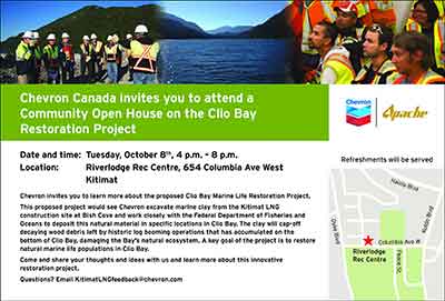
Chevron LogoChevron, the partner with Apache in the KM LNG (also known as Kitimat LNG) project at Bish Cove, said Sunday that the company will hold an open house in Kitimat on the controversial Clio Bay reclamation project.

Chevron says there will be a public open house at Riverlodge Tuesday, October 8 from 4 pm to 8 pm.

In an e-mail to politicians and local groups, including Douglas Channel Watch, Marc Douglas, a senior advisor for Chevron, based in Calgary, invited local stakeholders for a series of one hour meetings the same day at the KM LNG offices in City Centre.

Chevron Canada invites you to a meeting to discuss the Clio Bay Marine Life Restoration Project.
This proposed project would see Chevron excavate marine clay from the Kitimat LNG construction site at Bish Cove and work closely with the Federal Department of Fisheries and Oceans to deposit this natural material in specific locations in Clio Bay. The clay will cap-off decaying wood debris left by historic log booming operations that has accumulated on the bottom of Clio Bay, damaging the Bay’s natural ecosystem. A key goal of the project is to restore natural marine life populations in Clio Bay. Come and share your thoughts and ideas with us and learn more about this innovative restoration project.


Ad for open houseThere has been growing controversy over the Clio Bay project in recent weeks. Members of the Haisla Nation and residents of Kitimat were initially told that due to the large number of sunken logs at Clio Bay, that the area was deprived of oxygen, with limited sealife and that capping the logs with clay from Bish Cove would restore the ecosystem. However, beginning with a discussion at District of Kitimat Council on September 3, more people have been challenging the idea that Clio Bay needs restoration, with fishers posting photographs of recent catches on Facebook pages.

On Sept.3, Councillor Phil Germuth told Council:  “Those logs have actually created a woody reef, where like any other reef, an ecosystem is being sustained. So to say that those logs are suffocating the life out of Clio Bay doesn’t seem to have a lot of merit.”

At the time, Chevron told the media  that they had consulted with the Department of Fisheries and Oceans and  concluded that carefully placed clay would improve the ecosystem.

Special report: Clio Bay cleanup: Controversial, complicated and costly

[rps-include post=5057]

Gil Island “critical habitat” as humpbacks double at the mouth of Douglas Channel. New study says tanker traffic could threaten key spots

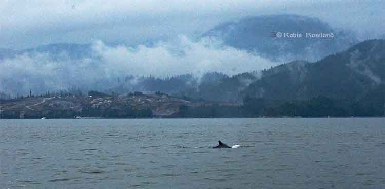
Humpback whale at Bish Cove
A humpback whale, seen here by its small dorsal fin, swims past the Chevron Apache KM LNG site at Bish Cove on Douglas Channel, August 21, 2013. (Robin Rowland/Northwest Coast Energy News)


Updated with comments from Gitga’at First Nation, Nathan Cullen and Shell Canada.

Gil Island is a “critical habitat” for the world’s humpback whales, whose numbers are increasing in Douglas Channel, Wright Sound, Estevan Sound and Camano Sound and nearby waters, according to a study released Wednesday, September 11, 2013. The study also goes on to warn that potential tanker traffic through the “geographic bottleneck” on Douglas Channel to and from Kitimat could threaten that crucial “pit stop” for the humpback whales.

The study, “Abundance and Survival of Pacific Humpback Whales in a Proposed Critical Habitat Area,” by Erin Ashe, of the University of St. Andrews, in Scotland, Janie Wray of Oceans Initiative on Pearse Island, Christopher Picard of the North Coast Caetacian Society in Hartley Bay and Rob Williams of the Gitga’at Nation Lands and Marine Resources Deptartment, is published in the jourrnal PLOS One.

The research team estimated the abundance of Pacific humpback whales by using photo-identification surveillance of adult humpbacks. They found that the number of humpback whales in this region increased each year, and doubled from 2004 to 2011, resulting in a total of 137 identifiable whales in 2011. The survey was conducted year-round. Abundance was estimated only during the summer months of July to September, when the migrating whale population is largest.

The survey focused on summer feeding regions in the northwestern BC coastal fjords that serve as a “pit stop” for whales between migrations. Migrating whales travel to the BC coast from calving grounds as far away as Mexico, Hawaii or Japan. After several months without feeding, the humpbacks arrive in BC, and, the study says, show “strong site fidelity to local feeding grounds” around the entrance to Douglas Channel.

The authors estimated that “survivorship,” the average probability of an adult whale surviving from one year to the next on the northwest coast of British Columbia is among the highest reported anywhere for the species. During “this critical refueling stage in these waters, the whales are more vulnerable to environmental stressors, such as those potentially created by increasing tourism and industrial development in the region.”

The study also says that study area has also been identified as candidate critical habitat for northern resident killer whales and notes the region “has been recolonized by fin whales in recent years.” (With details on the fin whales to come in future studies)

The study estimates there were once about 15,000 humpback whales in the North Pacific when whalers began hunting the animals. That number was down to 1,400 when whale hunting was stopped in Canada in 1966. “It is therefore good news that the segment of the population using our study area is growing and adult survival is near the limit that one would expect for this species. That said, although the population is recovering, there is no evidence that it has yet fully recovered to pre-exploitation levels in BC and we do not wish to become complacent.” the study says.

It goes on to say:

Humpback whales may be facing increasing threats in at least one of their proposed critical habitats in BC. Numerous port facility expansions and new terminal proposals, including numerous crude oil and liquefied natural gas (LNG) export proposals, could substantially increase deep-sea shipping traffic through BC’s north and central coast waters. Such developments could exacerbate oil spill, acoustic disturbance, and ship strike risks to humpbacks. In particular, the Gil Island proposed critical habitat area where our work was conducted, spatially corresponds with all shipping routes leading to Kitimat, BC port facilities that are currently being considered by regulatory agencies for high-volume crude oil and LNG tanker traffic and other increased shipping activities.

The monitoring program showed that “a relatively large fraction of BC’s humpback whales rely on the waters around Gil Island, given the small size of the study area.”


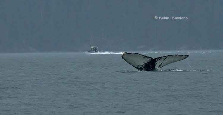
Humpback whale in Douglas Channel
The tail fins of a humpback whale are seen in Douglas Channel near Bish Cove, as a fishing boat speeds toward Kitimat harbour in a rain storm on Aug. 21, 2013. (Robin Rowland/Northwest Coast Energy News)

The study warns:

This high reliance on relatively small fractions of available habitat has important implications for conservation and management. It lends support to the proposal to designate the current study area as part of the population’s critical habitat…

This also suggests that area-based management for cetaceans can effectively target small areas if these areas are chosen carefully. The corollary to this, though, is that a tendency for animals to be concentrated or aggregated in small areas lends them vulnerable to catastrophic events like oil spills and ship strikes. Critical habitats like the Gil Island waters are therefore a mixed blessing when high densities of whales are found in geographic bottlenecks that also funnel and concentrate shipping traffic. Anthropogenic threats to this must be evaluated not only in terms of the proportion of available habitat that this area represents, but also in terms of its critical importance to large numbers of whales for critical life-history processes. The risk and ecological consequences of an oil spill in this region would increase substantially if proposals were approved to ship large volumes of oil and LNG traffic through the Gil Island waters. Studies in Pacific waters similar to our study area suggest that oil spills can have severe and chronic impacts to cetacean populations and it is uncertain whether affected populations can recover from such perturbations.

One reason for the study is that while the humpback is considered an endangered species in the United States, in Canada it is listed as “threatened” under Canada’s Species at Risk Act and the increasing numbers could mean that the humpback is downgraded to “special concern.”

The study was based on what is called “community based science,” a cost-effective partnership between scientists, the Gitga’at Nation and other First Nations, NGOs and the Department of Fisheries and Oceans.

As part of its Pacific humpback whale recovery strategy, DFO has proposed four areas as candidate critical habitat. One criterion for designating critical habitats within northern BC coast feeding grounds is that inlets are used for specialized ‘‘bubble-net’’ feeding behaviour (where the humpbacks create a fishing net of bubbles to catch their prey).

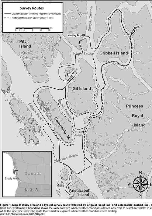
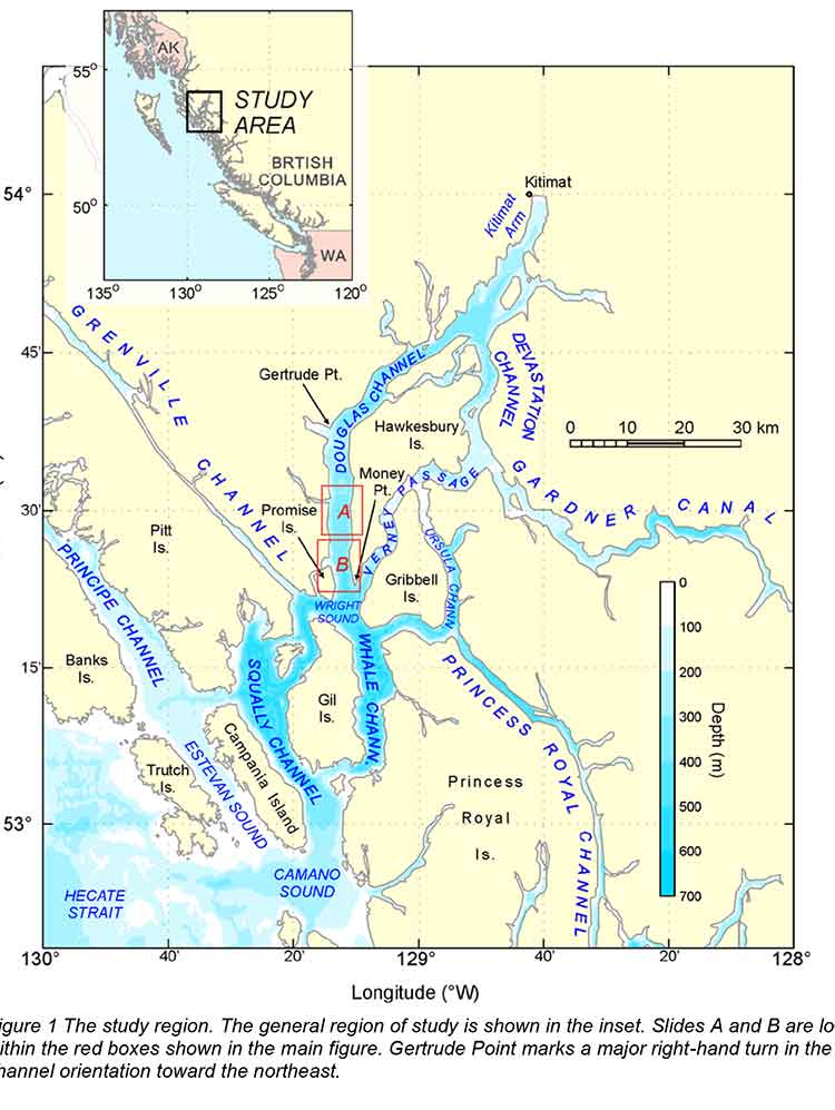
Map of study areaAt the start of the study, the team had noted that “mainland inlets have been somewhat under-represented in habitat studies” and so they began working on the photo-identification of the humpbacks, using two research groups, the North Coast Cetacean Society and the Gitga’at Lands and Marine Resources Department. Surveys were conducted as weather permitted throughout the year from April to November (with occasional trips in February, March and December), from 2004 to 2011.

The aim of the study was to “collect as many high-quality photographs of individually recognizable humpback whales as possible within the study area [referred to in the study  as ‘Gil Island waters’’] from Estevan Sound in the west to Ursula Channel in the east. One 27 foot and one 18 foot boat were used to conduct the surveys. A total of 374 photo- identification surveys conducted over 47 months resulted in a catalogue of 177 high-quality, unique identifications of individual humpback whales.

Information also came from “an informal sightings network including local fishermen and tourism operators who reported humpback and killer whale sightings over VHF radio;” hydrophones monitored for vocalizing humpback whales; and visual monitoring from the land-based Cetacealab facility on the south end of Gil Island.

When a humpback was sighted, they were identified by the fingerprint like tail flukes and the numbers cataloged.

The study was funded by grants to Cetacealab and Gitga’at First Nation from Julie Walters and Sam Rose, and from Fisheries and Oceans Canada (Cetacean Research Program, Species at Risk Program). There was also support from King Pacific Lodge.

Updates


In a news release, the Gitga’at First Nation said:

“The importance of our territorial waters for humpback and other species of whales, should give pause to those who would propose tanker routes through the Douglas Channel,” said Arnold Clifton, Chief Councillor of the Gitga’at First Nation. “The increase in whales in our territory coincides with low shipping traffic, however current proposals would increase shipping traffic to unprecedented levels. We remain resolute in our determination to protect whales and the natural heritage of our territory from tankers and other developments that would put them at risk.”
“Our study shows that while still vulnerable, humpback whales are recovering, and this area plays an important role in supporting their numbers,” said lead author, Erin Ashe, a PhD candidate at the University of St. Andrews and a co-founder of Oceans Initiative. “Identifying and protecting critical habitat is one of the most effective ways to support endangered species recovery.”
The waters around Gil Island are especially rich habitat for humpback whales, due to high abundance of their preferred foods, such as krill and herring and due to the remote nature of the coastal fjords. Humpbacks, which rely on acoustic communication, are sensitive to noise pollution from ship traffic.
“It is Cetacea Lab’s contention that all levels of government must collaborate with the Gitga’at First Nation and others in protecting humpback whales from the risk of increased tanker traffic,” said Janie Wray, whale researcher with Cetacea Lab. “This study represents the best available scientific information about the importance of this area to humpback whales. Over the course of our study, we have observed the population more than double, with mothers returning year after year with their calves, introducing the next generation of juvenile whales to the nutrient-rich feeding grounds of Douglas Channel to Caamano Sound.”


In his biweekly conference call with Northwest BC reporters, Skeena Bulkley Valley MP Nathan Cullen said: “I don’t get a sense from the way that the federal government has designed this [referring to Enbridge Northern Gateway] project, that on the marine side, any of these things are important to Mr. Harper. When you start to place down the most important values and certainly for British Columbians and Canadians, protecting a humpback feeding ground would seem like an important value in the Great Bear Rainforest, you start to see where the limits and the restrictions are on any idea of moving oil super tankers through such a narrow place. It’s just another bit of evidence, a bit of science that says this is difficult, if not impossible, and Enbridge’s project has made so many of those arguments more and more clear as we start to bring science to the table.

“It’s so frustrating for people that evidence, our opinions and our values just don’t seem to matter to the federal government. They already said yes to this thing years ago and damn the science, damn anything that comes their way. That’s not going to work, not going to work for us and not going to work for the humpback whales.”

A spokesperson for Shell’s LNG Canada project, noting that the company officials had not yet read the study, said, “It’s early days for the proposed project and the start of a thorough regulatory process. We welcome contributions and thoughts on important matters. We will look at this study. As with any project in Canada we work with local First Nations and local communities to minimize the impact of our activities.”

Neither Enbridge Northern Gateway nor Apache, a partner in the KM LNG project, responded to a request for comment.

DFO study on ancient Douglas Channel tsunamis shows minimal impact on Kitimat, devastation at Hartley Bay

A follow up study by the Department of Fisheries and Oceans on the discovery of prehistoric slope failure tsunamis in Douglas Channel concludes that the events would have had minimal impact on Kitimat but would have destroyed Hartley Bay.

The studies were filed by DFO with the Northern Gateway Joint Review Panel on Friday, November 16, following an earlier study the Geological Survey of Canada that reported the discovery of the submarine slope failures. The filing comes just three weeks after the region was shaken by a 7.7 magnitude earthquake off Haida Gwaii and a subsequent coast-wide tsunami warning.

The DFO follow up study was aimed at better understanding the dynamics of tsunamis during the two slope failure events on the southern end of Hawkesbury Island during the mid-Holecene period, between 5,000 and10,000 years ago.

The wave dynamic model study does not address the discovery by the Geological Survey of Canada of a possible fault line along Hawkesbury Island which could have been the cause of the slope failures.

The study estimates that the wave amplitude of the first tsunami reaching the proposed Enbridge Northern Gateway terminal site near Kitimat would have been about .09 to .12 metres. Since the actual wave height hitting land from a tsunami is one half of the amplitude, the height of tsunami waves reaching Kitimat at the time would have been about 60 centimetres or 23 inches. At Hartley Bay, on the other hand, the maximum estimated wave amplitude from the second tsunami would have been 15 metres, meaning a wave height of 7.5 metres or about 25 feet.

The main reason for the difference is that both the submarine slope failures occurred south of  the dogleg in Douglas Channel at Gertrude Point. That meant the configuration of the channel from Gertrude Point up to Kitimat would lessen the amplitude whereas because Hartley Bay was so close, it would be hit by a higher amplitude. The report says that because of their relatively short wavelengths, the tsunami waves undergo multiple reflections that the “high degree of scattering from the complex shoreline and bottom topography in Douglas Channel” would “combined with the flux of tsunami energy through adjoining waterways and channels” have caused a rapid decrease in the energy of the waves with distance south and north of the slide area.

The study also points out a crucial difference between the ancient slides and the two that occurred near Kitimat in 1974 and 1975, while the land near the head of the Kitimat arm were largely composed of material laid down by the glaciers, the large slope failures on Hawkesbury Island were blocks of an extremely hard igneous rock called diorite. Each of the prehistoric slides would have consisted of about 65 million cubic metres of rock.

The DFO report says

Coastal British Columbia is an area of steep slopes, extreme seasonal variations in soil moisture, large tidal ranges, and the highest seismicity in Canada. Hazards of this form have been well documented for the coastal region of British Columbia, and other fjord regions of the world’s oceans, including Alaska and Norway. These factors increase the potential for both submarine and subaerial slope failures in the region. Such events generally take place in relatively shallow and confined inner coastal waterways, and can present hazards in terms of tsunami wave generation.

The two prehistoric submarine slides are located about 10 kilometres apart on the
slope of southern Douglas Channel, near the southern end of Hawkesbury Island

The report says:

The failures are defined by scallop-shaped hollows located along the edge of the fiord wall and appear to be associated with detached blocks that extend out several hundred metres into the channel. The two block slides identified in Douglas Channel are characteristic of rigid-body submarine landslides, which differ considerably from the well-documented viscous submarine landslides with a lower specific gravity (density relative to water) of about 1.5 that occurred to the north of Douglas Channel along the inner slope of Kitimat Arm in 1974 and 1975.

The report’s modelling is “considered minimum values” because the do not include debris that would have spread into the fiord after initial slide. That debris is now buried by a thick layer of post-slide sediment.

DFO diagram of the model of Slide A on Hawkesbury Island (DFO)

The reconstruction model shows that the head of the more northern slide began at a depth of around 60 to 100 metre, while that of the more southern slide began at a depth of 75 to 120 metres.

The slides would have moved down slope at about 25 metres per second, coming to rest after about 30 seconds, 250 to 350 metres from the slope at a depth of 400 metres.

The northern slide, called by the scientists Slide A:

would have generated extremely large waves in the immediate vicinity of the failure
region within a minute of the submarine landslide. Waves in the numerical simulations reach amplitudes of 30 to 40 metres at the coast near the slide area

Submarine landslides cause delays between the arrival of the first waves and the arrival of subsequent higher waves, increasing in distance from the slide, because of “reflections and non-linear interaction” along the shoreline. For Slide A, the maximum wave amplitudes at Hartley Bay would have been six metres (meaning three metre waves) “Large amplitude waves with typical periods of around 50 seconds would continue for several tens of minutes.”

The leading tsunami waves generated by Slide A reach Kitimat Arm in roughly 20 min and have small amplitudes of only a few centimetres. Although later waves have higher amplitudes, the maximum wave amplitudes (which occur 50-55 minnutes after the failure event) are still only around 0.09 to 0.12 metres.

The southern slide on Hawkesbury, called Slide B by the scientists, would have moved 400 metres before stopping. It stared at a greater depth than Slide A, with not as much vertical displacement than Slide A. That means Slide B was slower than Slide A.

Slide B:

would have generated large waves in the vicinity of the failure region. Simulated waves reach the coast adjacent to the slide region within a minute of the failure event, with wave amplitudes of up to 10 metres. The waves also hit the opposite site of the channel within a minute of the failure event and then take an additional minute to reach Hartley Bay where waves reach amplitudes of 15 metres/ Powerful oscillations in the bay last for tens of minutes.
Waves with high amplitudes (more than 2 metres) also occur in the southern part of Douglas Channel, and in certain locations of Verney Passage.

According to the models, the leading tsunami waves would have reached the Kitimat Arm 22 minutes after the start of the slide. The maximum waves would have had amplitudes of 0.08 metres to 0.3 metres (6 inches), reach the Kitimat Arm 45 to 60 minutes after the start of the failure event.

The the tsunami waves generated by Slide B that impact Kitimat Arm,  although still of low amplitude, were somewhat higher than those generated by Slide A, despite the fact that Slide B was located further to the south and generated less energetic waves in the source region than Slide A.

This seeming paradox is explained by the slower motion of Slide B, which causes it to generate more wave energy in the low frequency band…Due to their reduced scattering and reflection, the relatively long and lower frequency waves generated by Slide B propagate more readily through the complex fjord system than the relatively short and higher frequency waves generated by Slide A.

Specifically addressing the proposed site of the Enbridge bitumen terminal, as well as potential tanker traffic in Douglas Channel, the detailed explanation of the modelling accompanying the DFO report says:

If similar submarine slides were to occur again somewhere in the same general area, they could present a significant risk to navigation and to nearby shore installations and coastal communities….

As with the tsunami generation regions, the highest waves and strongest currents in any particular region of the coastal waterway would occur near the shoreline. Based on the numerical findings, tsunamis generated by submarine landslides of the form identified for the southern end of Douglas Channel would have heights and currents that could have major impacts on the coastline and vessel traffic at the time of the event throughout much of Douglas Channel, but a minor impact on water levels, currents and hence vessel traffic in Kitimat Arm. Hartley Bay, at the southern end of Douglas Channel, would be impacted by high waves and strong currents, whereas Kitimat, at the northern end of Kitimat Arm, would experience negligible wave effects. Additional modelling would be required to assess the characteristics of possible tsunamis originating beyond the area of the two identified slope failures.

At the estimated propagation speeds of about 65 metres per second, the detailed model says it takes roughly 10 to 15 minutes for the simulated waves to propagate approximately 40 to 45 kilometres to the intersection of Douglas Channel and Kitimat Arm, where peak wave amplitudes would be diminished to less than one metre. It takes another 15 minutes for the waves to reach sites near the proposed Enbridge facilities in Kitimat Arm where wave amplitudes would be reduced to a few tens of centimetres and associated currents to speeds less than a few tens of centimetres per second.


Slide tsunami area map
Slide tsunami area study map (DFO)


Fisheries and Oceans-Modelling Tsunamis Associated with Recently Identified Slope Failures in Douglas Channel  (pdf)

Numerical data for DFO tsunami study (link to JRP)


Release of Douglas Channel tsunami report postponed to November 16

The Northern Gateway Joint Review panel has allowed the Department of Fisheries and Oceans and Natural Resources Canada to delay a report on historic tsunamis and a possible fault line on Douglas Channel until November 16, 2012.

The report was scheduled for release on October 31.

In a ruling released by the JRP on November 1, the panel noted:

In Ruling no. 105 dated 24 September 2012, the Panel stated that the Department of Fisheries and Oceans (DFO) could provide “modelling of the potential wave heights and speeds that may  have resulted from two previously unrecognized submarine slope failures in the Douglas  Channel” (Modelling) and that it should do so by 31 October 2012. The letter from Justice Canada seeks an extension to 16 November 2012 as DFO “requires additional time to complete the peer review and approval processes related to this additional written evidence.”
The Panel believes the Modelling to be relevant, as noted in Ruling no. 105. The Panel is also ofthe view that there is unlikely to be any undue prejudice to any party by permitting its filing to be delayed to 16 November 2012.

Accordingly, the Federal Government Participants’ motion is granted and DFO is permitted to file the Modelling on or before 16 November 2012

A preliminary report was released in early September and outlined evidence of major slope failures on the islands in Douglas Channel and also a possible fault line along part of the Douglas Channel.

The Department of Justice filed the request with the JRP on Monday Oct. 30, 2012, less than 48 hours after a major earthquake of magnitude 7.7 struck off Haida Gwaii just after 8 p.m. Pacific Daylight Time, on Saturday Oct. 27, shaking much of northern BC. There have been numerous aftershocks since the main quake.

Panel-Commission Ruling 130 Slope failure report (PDF)

BC’s desire for “world leading” marine standards collides with Harper’s C-38 chain saw massacre

Today BC Premier Christy Clark’s government outlined a series of “world leading” standards for environmental protection on the ocean and on land, if pipeline projects like the Northern Gateway and the Kinder Morgan expansion are to go ahead.

One has to wonder what Premier Clark told Prime Minister Stephen Harper when she gave him the “heads up” call on the new policy last week?

After all, the BC Liberal’s call for “world leading” standards comes just weeks after the Harper’s government, in Bill C-38, changed environmental assessment into a pro-industry process, gutted the Fisheries Act protection for habitat and severely cut back the Department of Fisheries and Oceans and Environment Canada.

So far, in the province of British Columbia, with both the governing Liberals and opposition New Democrats have been spectacularly unsuccessful in persuading the Harper government to reverse the closure of the Kitsilano Coast Guard station.

In the background paper released along with the news release on the five conditions for pipeline and tanker safety, the BC government is calling for greatly enhanced Coast Guard resources and tanker monitoring as well as payment for oil spill response.

Among the conditions for marine safety enhancement BC is asking:

  • Current response times and planning capacity are less stringent than other jurisdictions like Alaska and Norway. For example, for the types of tankers being proposed for Canada’s west coast, Alaska requires planning for 300,000 barrels. In Canada, response organizations are only required to maintain response plans for spills up to approximately 70,000 barrels (10,000 tonnes). Further, Alaska allows responders 72 hours to reach the spill site, while Canada allows 72 hours plus travel time, which can sometimes add days to the response.
  • In shared bodies of water, the United States’ requirements exceed Canada’s. For example, the United States requires escort tugs for laden tankers and mandates industry pay for designated and strategically placed emergency response tugs. Canada does not have any similar requirements.
  • Ensure the Canadian Coast Guard adopts a unified command/incident command structure.
  • The Canadian Coast Guard has a unique response system which is only used in B.C. The United States, companies and governments worldwide use a unified command/incident command response structure for a range of emergency responses, including marine spills. By bringing the Coast Guard under this system, an effective, co-ordinated response is better ensured while reducing layers of approvals that can delay critical, prompt decision-making.

At Enbridge community briefings in Kitimat last year, the company’s own marine experts said that the 72 hour  response time from Vancouver and Victoria for a possible spill in the Douglas Channel was completely inadequate. In its fillings with the Joint Review Panel, Enbridge has proposed setting up and funding its own response stations along the BC coast, although so far, Enbridge has not provided any details on how the response stations would be set up and how they would work.

In 2010, the auditor general reported that Transport Canada and the Canadian Coast Guard have not used a consistent or systematic approach to tanker traffic and spills nor are there formal processes for ensuring that risks are reassessed.

Sheila Fraser found that

  • Procedures are not in place to verify the Canadian Coast Guard’s readiness. In other words, there is currently no process for providing assurance that the federal component of the oil spill response system is ready to respond effectively.
  • The Coast Guard had not conducted a comprehensive assessment of its response capacity since 2000.
  • The results of the Coast Guard’s response efforts—which range from identifying the source of pollution to full cleanup—are poorly documented. There are also limitations with the Coast Guard’s system for tracking oil spills and other marine pollution incidents. These gaps affect its ability to conduct reliable analysis of trends in spills and know how well it is achieving its objectives of minimizing the environmental, economic, and public safety impacts of marine pollution incidents.

In the United States Senate, Canadian Coast Guard response for an oil spill in the Strait of Juan de Fuaca  was described as “call the Americans”

For some search and rescue missions the federal government has indicated that it will rely more on the all-volunteer Royal Canadian Marine Search and Rescue service (formerly the Coast Guard Auxiliary) which is already stretched thin in some areas of the Pacific Coast, rather than the full time professionals from the Coast Guard service itself.

On the industry response, BC says

The federal government should review its rules and requirements to ensure industry-funded response funds are sustainable and adequate to fully cover a major response without requiring public money. Currently, the total amount of ship owner insurance and industry funding available for spill response is $1.3 billion. By comparison, the U.S. federal government maintains a spill fund that is forecast to grow to nearly $4 billion by 2016.

Again given the government backs and the Conservative government’s close ties with the energy industry, one has to wonder what if those provisions can be enforced, especially since more and more of the energy industry in Canada is owned off shore, increasingly in China with its sorry environmental record. (Globe and Mail CNOOC’s Nexen bid: A new test for Harper)

If there are to be “world-leading” standards for environmental protection in this country, it has to be paid for. So the question remains, who will pay for it? The federal government is cutting back, Alberta doesn’t want to raise the relatively small royalties it charges the energy industry and Canada is not likely to get a contribution from China.

Who pays to protect the coast and the northern interior going to be a big question for Stephen Harper in the coming months. With the polls showing Adrian Dix and the NDP leading in contention for a provincial election next year, and now with Christy Clark, apparently, demanding higher standards, will Harper open the Ottawa wallet now, will he wait until he faces a much tougher BC premier in Adrian Dix next year, or will he stubbornly hold his course of forcing Canada into his vision of a conservative, limited government nation, with, in the case of an oil spill on land or sea, that will cost the federal treasury billions, even if the energy industry picks up some of the tab?


Auditor General 2010 Report (pdf)

Auditor General 2007 report  (pdf)


DFO report to JRP says Northern Gateway pipeline will cross “high-risk” streams but releases only two examples on Kitimat watershed

A Department of Fisheries and Oceans report filed Wednesday, June 6, 2012, with Joint Review Panel says the department has identified streams on the Northern Gateway Pipeline route that Enbridge identified as “low risk” but which DFO considers “high risk.” However, in the filing, DFO says it can’t release a comprehensive list of the high risk streams, preferring instead to give two examples on the Kitimat River watershed.

The DFO report comes at a time when the Conservative government is about to pass Bill C-38, which will severely cut back DFO’s monitoring of the majority of streams. It appears that the anonymous DFO officials who wrote the report acknowledge that they may soon have much less monitoring power because the report says:

Under the current regulatory regime, DFO will ensure that prior to any regulatory approvals, the appropriate mitigation measures to protect fish and fish habitat will be based on the final risk assessment rating that will be determined by DFO.

Note the phrase “under the current regulatory regime.”

The report also identifies possible threats to humpback whales from tanker traffic.

In the report, DFO notes that Northern Gateway’s “risk management framework” is based on DFO’s own Habitat Risk Management Framework, and DFO, notes “the approach appears to be suitable for most pipeline crossings.”

However, DFO further remarks that it has identified

some examples where crossings of important anadromous fish habitat have received a lower risk rating using Northern Gateway’s framework than DFO would have assigned. In addition, DFO has identified some instances where the proposed crossing method could be reconsidered to better reflect the risk rating.

In bureaucratic language, the Department says “DFO reviews impacts to fish and fish habitat and proposed mitigation measures through the lens of its legislative and policy framework” again a strong hint that the legislative and policy framework is about to change.

It goes on to say:

The appropriate approach to managing risks to fish and fish habitat is based on the risk categorization. For example, where high risks are anticipated DFO may prefer that the Proponent use a method that avoids or reduces the risk such as directional drilling beneath a watercourse to install the pipeline. If low risks are anticipated other methods such as open-cut trenching across the watercourse may be appropriate.

While DFO is “generally satisfied” with Northern Gateway’s proposed approach, it says “DFO has identified some crossings where we may categorize the risk higher than Northern Gateway’s assessment.”

DFO then gives Enbridge the benefit of the doubt because:

Northern Gateway continues to refine the pipeline route and we anticipate that assessment of risk will be an iterative process and, if the project is approved and moves to the regulatory permitting phase, DFO will continue to work with Northern Gateway to determine the appropriate method and mitigation for each watercourse crossing. In DFO’s view, Northern Gateway’s approach is flexible enough to be updated if new information becomes available.

DFO then says it

has not conducted a complete review of all proposed crossings, we are unable to submit a comprehensive list as requested; however, this work will continue and, should the project be approved, our review will continue into the regulatory permitting phase. While there may be differences in opinion regarding the risk categorization for some proposed watercourse crossings, DFO will continue to work with Northern Gateway to determine the appropriate risk rating and level of mitigation required.

Here is where DFO points to current, not future policy, when it says:

DFO is of the view that the risk posed by the project to fish and fish habitat can be managed through appropriate mitigation and compensation measures. Under the current regulatory regime, DFO will ensure that prior to any regulatory approvals, the appropriate mitigation measures to protect fish and fish habitat will be based on the final risk assessment rating that will be determined by DFO.

The report then gives two examples of high risk streams both in the Kitimat River watershed


Example 1) Tributary to the Kitimat River, KP 1158.4 (Rev R), Site 1269

Northern Gateway Rating: RMF: Low Risk

DFO Rating: RMF: Medium to High Risk

Rationale: This is a coastal coho salmon spawning stream that is quite short in length. It has several historic culverts in poor repair which are already impacting the reported run of approximately 100 spawning salmon. Works can be completed in the dry as this stream dries up during the summer. DFO is of the opinion that the risk rating is higher than that proposed by Northern Gateway due to the sensitivity of incubating eggs and juveniles of coho salmon to sediment and the importance of riparian vegetation for this type of habitat.


Example 2) Tributary to the Kitimat River, KP 1111.795 (Rev R), Site 1207

Northern Gateway Rating: RMF: Medium Low Risk

DFO Rating: RMF: Medium to High Risk

Rationale: In DFO’s view the risk rating for this watercourse is higher than that proposed by Northern Gateway because this stream is high value off-river rearing habitat for juvenile salmon such as coho salmon. This type of fish habitat is vulnerable to effects of sedimentation and loss of riparian vegetation.


Humpback Whales

The Joint Review Panel also asked DFO for a comment on the status of the humpback whale, especially in the shipping area in the Confined Channel Assessment Area Between Wright Sound and Caamaño Sound.

DFO responds

Four areas of critical habitat were proposed for humpback whales in coastal British Columbia in the Draft Recovery Strategy released in 2010, including the Confined Channel Assessment Area from Wright Sound to Caamaño Sound. However, humpback whales have recently been re-assessed by the Committee on the Status of Endangered Wildlife in Canada (COSEWIC) and were redesignated ‘Special Concern’ but remain ‘Threatened’ under the Species at Risk Act (SARA). A draft recovery strategy for the humpback whale has been prepared.
It is unclear if humpback whales are still protected as a Schedule 1 status species under the SARA and whether a recovery strategy has been finalized.

Fisheries and Oceans Canada Response to the JRPs IR Request  (pdf)

Editorial: Pipeline politics are now hyperlocal. Government and energy companies must deal with it.

There’s a glaring misconception in the move by Stephen Harper’s government in Thursday’s budget to speed up the review of resource projects, including the Northern Gateway Pipeline. The government wants reviews to last between 12 and 24 months and to avoid duplication between the federal and provincial governments. The buzzword is “one project, one review.”

The misconception is that natural resource reviews can go on as they have since the 1980s when the deregulation craze made any kind of resource hearing, especially those before the National Energy Board, into a private club for the oil patch, government and energy lawyers. NEB hearings are plagued by arcane rules of procedure and evidence that were, probably in an “out of mind out of sight” way, created to exclude the public. The public, despite the consultation mandates of the review agencies, didn’t really matter a damn. It is likely with the changes brought in by the Harper government, with its vocal hostility to the environmental, the public will matter even less.

A second misconception promoted by the government, by right-wing think tanks and supported by a lot of the media is that the Northern Gateway Joint Review Panel has been sort of hijacked by the green movement with sole purpose of delay, delay, delay.

The problem is that none of these people, not Finance Minister Jim Flaherty, not the Prime Minister, not the columnists, nor academics for universities or think tanks have attended many (or any) of the hearings or read the transcripts. They don’t look at the lists of intervenors, those who have said they want the opportunity for a 10 minute comment or filed letters of comments.

What has changed in just the last five years or so, just as Northern Gateway was getting underway, was the rise of social media, blogging, Facebook, Twitter, YouTube. The widespread use of social media means that despite the efforts of Stephen Harper to stifle opposition, pipeline hearings now and in the future will be governed by —let’s call it the “British Columbia Spring.” If the hearings are curtailed by the government, social media isn’t going away and those opposed to the pipeline will simply find ways to escalate their protests.

It’s not green manipulation that is delaying the hearings, it is that pipeline hearings have become “hyperlocal”* as social media makes everyone aware of what’s going on. That means that each neighbourhood, each village, each block, each wharf now know how a pipeline will affect their lives. This applies to the First Nations across the pipeline route and down the coast; anyone who drives BC’s highways and sees avalanche gates and avalanche warnings; commercial salmon, halibut and herring fishers; the ailing forestry industry. It’s not just BC, it’s a farmer in Nebraska, a rancher in Texas, a homeowner in Michigan, a shrimp fisher in Louisiana. Their worries are available on Google, Facebook, Twitter in a way that wasn’t possible just a few years ago, when stories about NEB hearings were buried in small paragraphs on the back pages of the business section of a newspaper.

Although the right-wing media loves to concentrate on a couple of people from Brazil who may or may not have signed up inadvertently, the vast majority of the 4,000 people who are scheduled to speak before the Joint Review Panel are vitally concerned about strictly local issues. Scheduled to speak is now the operative term because it is likely that the Harper government will cut off the opportunity to speak, and that will only further decrease the already shaky credibility of the Joint Review Panel with the people of British Columbia directly affected by the Northern Gateway.

One of the most perceptive academics in the energy field, economist Andrew Leach (albeit based at the University of Alberta) led a discussion on Twitter opening it with this question

Can anyone provide a single piece of evidence that longer environmental processes, beyond a certain point, yield higher quality evaluation?

Again, no evidence of this beyond a certain pt. Long process often cited as evidence of sound analysis, but two are not same.

IMO, there’s no reason that, w proper resources, you could not fully assess impacts & set appropriate conditions for major projects in 2yrs.

Context: NGP JRP decision is expected now at the end of 2013, roughly 4 years after hearing order issued, but <2 yrs after first hearings.

Leach makes two shaky assumptions.

The first assumption is that the hearings can come up with a quality evaluation and sound analysis. But a quality evaluation, sound analysis for whom? For the private club that the NEB has been for the past quarter century? Sound analysis from a government that muzzles its own scientists and cuts funding for proper research and now wants to have the Canada Revenue Agency harass its environmental opponents? As the responses by First Nations and local groups to the filings by Enbridge show, counter analysis often takes years of research and lots of money. Sound analysis if the opponents are given limited opportunity to respond to a proposal?

The second assumption is that the current and future hearings are going to be fair, independent and transparent. In his conference call yesterday with local reporters, Skeena Bulkley Valley MP Nathan Cullen said the Joint Review and future hearings are “rigged,” predicting that “people won’t stand for this” and it “will only hurt the company it’s supposed to protect.”

The panel has already heard a large number of intervenors in various communities across the northwest tell them directly that the process has no credibility. The decision by the Harper government to speed things can only increase the belief that the hearings are unfair, are rigged, that building the pipeline is a foregone conclusion.

Or quality evaluation for the people directly affected?

Testimony before the Joint Review Panel has been about hyperlocal issues, the state of an estuary, the legacy of the poisoning of a stream by now defunct paper mills, one aboriginal family’s traditional trapline, the shellfish beds polluted by the Queen of the North sinking, the danger to culturally modified trees, the fact that the pipeline will bring no more than a handful of jobs to British Columbia, while endangering thousands fishing and tourism jobs. You might want to call that “Not In My Back Yard” but then the Calgary water supply won’t be out of operation for four years as could happen in a worst case scenario for the Kitimat River in case of a pipeline breach along the river or its tributaries.

If the public believes that future hearings are not “quality evaluation” but rigged in favour of the energy industry, then there will be resistance there as well. What kind of resistance the decision will bring remains to be seen. But that resistance, whatever form it takes will likely also be a factor in any future resource hearings.

Then there is the question of jobs. There just aren’t going to be that many jobs in British Columbia from the Northern Gateway pipeline. First Nations communities, in the unlikely event they agreed to a pipeline, will see no long term benefit from temporary construction jobs. How many Canadian jobs will there be, if the rumours that been circulating in Kitimat for months now are true that PetroChina will build the pipeline? ( recently somewhat confirmed by the Financial Post, although also characterized by Enbridge as speculation)

Don Cayo, writing this morning in the Vancouver Sun says

But the biggest deal in the budget by far, at least as far as the West is concerned, has nothing to do with spending. It is the intention to clean up, at long last, the snarl of red tape that has become such an impediment to development in the resource sector….

it’s a spurious argument to try to link the efficiency of the regulatory process and the fairness of it. “Slow” is not a synonym for “good” nor is “faster” another word for “worse.” It does immense harm to the economy and no good to anyone at all, as history proves, to have a Byzantine process that is obscenely expensive for both the public and private sectors.

Nor is the pipeline the only project in need of fair and reasonably fast assessment. The West in general and B.C. in particular are awash in potential projects — mines, energy developments and more — and we’ll all be better off knowing sooner rather than later which ones are appropriate to move forward.

This simply shows that the advocates of the fast track process don’t get it. They are stuck in the small c conservative mantra of cutting “red tape.” There have been no recent changes in the red tape. The National Energy Board procedures, as I said, are already unfriendly to the ordinary public.

What has changed is that with the web, with social media, the people directly affected, who in the past would have been frozen out of the procedures by lack of communication, are now participating to the fullest extent possible, using information gleaned from the web and empowered by social networks. That isn’t going to change.

As much as the Conservative government believes it control the agenda, and the procedures of the resource hearings, it can’t. All it takes for a hearing to be overwhelmed is a lot of concerned residents, acting on their own, not pushed by ENGOs, prodded by a single e-mail, Tweet or Facebook post.

It may be that the energy industry, a decade from now, will regret what they wished for, a fast track process that is actually bogged down in all the kinds of court challenges that lawyers can work up, regional and municipal zoning barriers, sympathetic bureaucratic delays at the provincial level, civil disobedience, including blockades on land and sea bringing Canada a growing international media black eye, beyond the current impression of the bitumen sands as Mordor. As much as Harper may not like it, if an Oscar-winning star is arrested at a pipeline blockade it will be international news.

To use a a current analogy, with the centenary of the sinking of the Titanic approaching, the Steerage passengers are now demanding a place at the First Class table, along with the haughty oil barons, the high priced lawyers and holier than thou consultants. Stephen Harper and Jim Flaherty may close some of the gates between Steerage and First Class, but eventually the Third Class passengers will find a way to the upper decks.

(Every time someone from Enbridge at a Kitimat meeting says how safe the oil tankers and their escorts will be, one audience member always brings up the Titanic in a question and answer session)

Notes

1. *What is hyperlocal?

Hyperlocal is usually a term in online journalism, referring to coverage of a specific neighbourhood. In some ways, Northwest Coast Energy News, based in Kitimat is a hyperlocal site. That is why it is easy to recognize the hyperlocal nature of those who testify at the Joint Review Hearings. It can be as hyper hyper local as the pipeline crossing a skiing/hiking trail.

For a longer, somewhat academic definition of hyperlocal, the Wikipedia entry may be valuable.

2. Scope creep and dismissing local concerns

In a paper for the conservative C. D. Howe Institute, Leach’s colleague Joseph Doucet, Interim Dean of the University of Alberta School of Business, UnClogging the Pipes; Pipeline Reviews and Energy Policy, complains about what he calls “scope creep” in NEB hearings and says:

It is not simply not efficient or effective to attempt to solve broad, far-reaching societal challenges such as First Nations land claims or greenhouse gas emissions policy through individual project reviews.

and concludes

Regulatory review should focus on relatively narrow project definitions consistent with the impacts of the project , including its relevant costs and benefits and the scope of the activity of the proponent, Other issues, broader and more general in nature should be dealt with in statue or in policy, not in regulatory review.

There is one thing missing in Doucet’s analysis. The “scope of activity” of people directly affected by a pipeline project. What he calls “scope creep” has occurred due to the rise of public awareness due to the web and social media. In his paper, the lives of the local residents and hyperlocal issues are simply written off.

Doucet ignores that fact this government’s policy, while spinning respect for the environmental issues in single paragraphs, is to bulldoze the pipeline across BC, no matter what the consequences. On one hand, the Harper government pushes the pipeline as a gateway to Asian markets. On the other hand, with the $80 million cut to the Department of Fisheries and Oceans, with cuts to Environment Canada and support for independent environmental research, cuts to the Canadian Coast Guard, the policy is clear, the Harper government is ignoring the potential catastrophe from an oil pipeline breach or tanker disaster.

Enbridge Northern Gateway, on the other hand, does have contingency plans for such events, but at meetings in Kitimat, even Enbridge officials have expressed public scepticism about how much government support there could be in the event of a disaster.  In fact, if the Harper government had more respect for the environment and actually had plans to counter a potential disaster, there likely would be less opposition to the Northern Gateway.

The only way to have any check and balance on the Harper bulldozer is to have an effective, thoroughly independent and wide ranging inquiry process, not a narrow one aimed at tweaking regulations.


Minister issues non-denial denial on taking habitat protection out of the Fisheries Act

On Friday, March 16, Fisheries Minister Keith Ashfield released a brief statement denying that the government had made a decision to take habitat protection for fish out of the Fisheries Act (Earlier in the week reports had leaked saying that government intended to take protections for fish habitat out of the act, as way of clearing the way for industry.)

Ashfield’s statement, which came at 4:40 p.m. Eastern Time appeared to be the classic buried government news release issued late on  a Friday.  The release actually did not deny facts of  the leak, making it also a classic non-denial denial.

Ottawa (Ontario) – The Minister of Fisheries and Oceans today issued the following statement:

“The government is reviewing fish and fish habitat protection policies to ensure they do not go beyond their intended conservation goals. Recent speculation about the current review is inaccurate. No decision has been made.

“The government has been clear that the existing policies do not reflect the priorities of Canadians.

“We want to focus our activities on protecting natural waterways that are home to the fish Canadians value most instead of on flooded fields and ditches.”

It is clear that Conservative policy, such as proposed changes to the Environmental Assessment Act and budget cuts at Environment Canada, is to eliminate as many environmental protections as possible, and so the sentence that policies “do not go beyond their intended conservation goals” must be interpreted in light of the environmental record of the Conservative government.

On March 13, media including The Globe and Mail  Ottawa wants to bow out of regulating fish habitat, documents show and The Vancouver Sun, Canada poised to ‘gut’ fish protection laws, biologist claims reported that the Conservatives want to get government out of the job of regulating fish habitat, so projects such as the Enbridge Northern Gateway pipeline can be fast tracked.

Otto Langer, an aquatic ecologist who worked for the federal government for 32 years, obtained the documents and made them available to the media.

He said the documents show that the government intends to remove the requirement in the Canada Fisheries Act to protect fish habitats for any fish that is not of “economic, cultural or ecological value.”

Langer told The Globe and Mail: “Probably the main reason why the oil industry, especially in the Prairie provinces, wants it out of the act is its use triggers [a review under] the Canadian Environmental Assessment Act. If you are going to do harm to habitat, you have to do an environmental review and that takes time and money.”

Speaking to The Vancouver Sun Langer asked how the government could define
“what is a fish of economic, cultural or ecological value?”

Documents obtained by PostMedia news, as reported in The Vancouver Sun story, say that energy and other industries consider the Fisheries Act a irritant that holds up projects.  One of the documents say:

“Some of the largest and most complex natural resource and industrial development projects across the country are affected by Fisheries Act requirements, which are consistently identified as one of the top federal regulatory irritants by stakeholders across the country,”

In his bi-weekly conference call with northwestern reporters, earlier Friday, before Ashfield issued his statement, Skeena Bulkley Valley NDP MP Nathan Cullen said he has heard the “the government is planning to take the word ‘habitat’ of Section 35 of the Fisheries Act and then ram that potential change into a budget bill.

“This is what the fisheries act is for, to protect habitat,” Cullen said. “Protecting habitat is one of the most crucial factors in protecting fish stocks. If you can’t protect habitat, then how do you protect fish?

If they do this,” Cullen said, “They’ll rip the very heart out of the Fisheries Act. The heart and soul of the act is that if you want to protect fish, you must consider habitat. You don’t have to be a genius or a fish biologist to know that if the fish don’t have anywhere to spawn, you’ll kill the fishery.”

Cullen said if the government does go ahead with the changes, “it will further compound all the problems and stresses we’ve been putting on the fishery. Essentially the government is saying that wild fish populations will not matter, that oil and gas is going to trump them every single time.

He went to say, “They did this with the Navigable Waters Act a few years ago They killed off a one hundred year old act that was designed to protect waterways in Canada. You know who it upset, and this is something the government is going to have to be paying attention to is the BC Wildlife Federation, the anglers and hunters associations, any of those groups that likes the go out into nature and actually see some nature. All of those groups got upset last time and now its going to be that times ten.“

Ashfield’s statement about flooding referred to a couple of incidents where the Department of Fisheries and Oceans would not allow draining of  flooded areas. He told the House of Commons “Last year in Saskatchewan, a long-running country jamboree was nearly cancelled after newly flooded fields were deemed fish habitat by fisheries officials. In Richelieu, the application of rules blocked a farmer from draining his flooded field.”

In response, The Globe and Mail quoted Adam Matichuk, fisheries project co-ordinator for the Saskatchewan Wildlife Federation, said that, during high-water events, many fish species move into flooded areas to feed and reproduce.

“The Craven area is basically a flood plain,” he said. “It doesn’t flood every year, but, when it does, fish take advantage of it. There were hundreds of thousands of young fish, mostly pike and walleye, in there when they turned on those pumps,” he said.