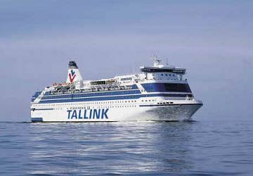
Rio Tinto Alcan and the Kitimat Modernization Project (KMP) are chartering a converted Baltic ferry to expand the modernization project’s work lodging for nine months, as the company gears up for “the final construction year,” RTA said Tuesday in a news release.
The ship, the Motor Vessel Silja Festival, will be renamed the “Delta Spirit Lodge” in honour of the first ship used for worker accommodation in the early days of the Kitimat project, the Delta King.
M/V Silja Festival
RTA says the ship left Estonia on Monday and is expected to arrive in Kitimat near the end of February. The ship “will have a service staff of approximately 110 and will offer first rate amenities including 500 bedrooms, kitchen, dining and lounge facilities.” The “Delta Spirit Lodge” will dock at RTA’s “Terminal B,” the former Eurocan wharf for the duration of the contract.
The charter agreement was made in cooperation with Transport Canada and Bridgemans Haisla LP to provide the accommodation services. RTA spokesperson Colleen Nyce said in the release, “With the decision to secure a very large accommodation ship, Rio Tinto Alcan has taken another responsible action to ensure that the temporary workforce associated with the Kitimat Modernization Project causes minimal burden on its host community.”
The 34,414 gross tonne, 171 metres overall, eleven deck ferry was built in Aker Finnyards in Helsinki, Finland and went into service on September 1, 1986, as a passenger and roll on roll off ferry. It was renamed the Silja Festival in 1991 and refitted in 1992. It has 588 passenger cabins, plus restaurants, a show bar, shops, cafés, a sauna and conference facilities. The ship also boasts a casino.
The registered owner is the Tallin Swedish line, based in Tallinn, Estonia. It is managed by HT Shipmanagement of Riga, Latvia and flags the Latvian flag.
Earlier a news release from US Shipbrokers announced the deal, saying:
US Shipbrokers is pleased to announce that we have just facilitated with co-brokers the Charter/Purchase of the M/V Silja Festival from her owners Tallink Group to Canadian interests . The Cruise Ferry Silja Festival will be used as an accommodation vessel for a construction project in British Columbia. US Shipbrokers was contacted by charterers in December due to our vast experience with accommodation charters throughout the United States and the Caribbean, and with our network of worldwide brokers and our proven results, we were able to close this charter/purchase within one month.
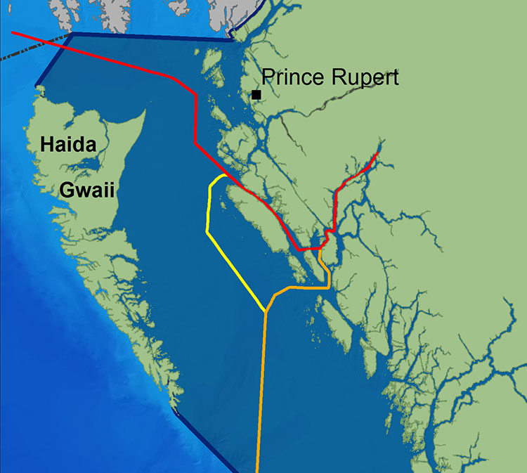
(First in series of reports on how the Joint Review Panel report will affect the Kitimat region)
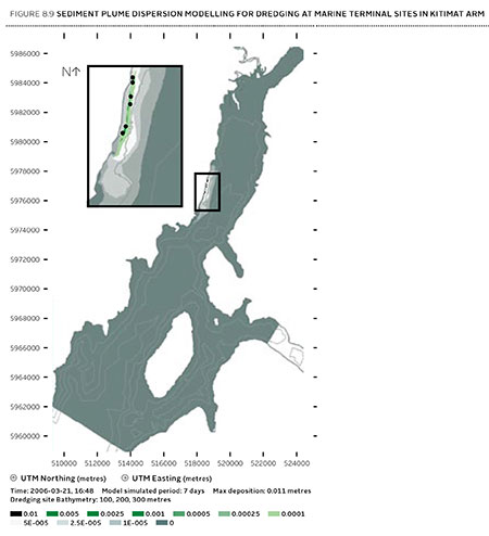
Joint Review map of Northern Gateway plans for dredging and blasting on Douglas Channel (JRP)
If there is a significant flaw in the Joint Review Panel report on Northern Gateway, it can be found in the panel’s analysis of Enbridge Northern Gateway’s plans to blast and dredge at the proposed Kitimat terminal site.
While the Joint Review Panel does consider what it calls “cumulative effects,” the panel plays down those effects and offers no specifics about interaction between the Northern Gateway project and the two liquified natural gas projects, the KM LNG project at Bish Cove and the BC LNG floating terminal at the old log dump.
It appears the JRP considered the legacy effects of the Rio Tinto Alcan smelter and other Kitimat industries while not taking into consideration future development.
The dredging and blasting planned by Northern Gateway, as Enbridge said in its evidence, appears to have only a minimal effect on Douglas Channel.
A glance at the map in the Joint Review ruling shows that that the dredging and blasting site is directly opposite Clio Bay, where Chevron, in partnership with the Haisla Nation, plan a remediation project using marine clay from the Bish Cove construction site to cap decades of sunken and rotting logs.
The Clio Bay project was not part of the evidence before the Joint Review Panel, the plans for the project were not formulated until well after the time for evidence before the JRP closed. But those deadlines show one area where the rules of evidence and procedure fail the people of northwestern BC.
The JRP is a snapshot in time and changes in the dynamics of the industrial development in the Kitimat Arm are not really considered beyond the terms of reference for the JRP.
It appears from the report that Enbridge plans to simply allow sediment from the blasting and dredging to float down Douglas Channel, dispersed by the currents and the outflow from the Kitimat River.
Northern Gateway said that dredging and blasting for marine terminal construction would result in a sediment plume that would extend over an area of 70,000 square metres for the duration of blasting activities.
Approximately 400 square metres of the assessed area of the marine terminal is expected to receive more than 1 centimetre of sediment deposition due to dredging. Outside of this area, typical sediment deposition levels alongshore where sediment is widely dispersed (a band approximately 4 kilometres long and 400 metres wide) are very low; in the range of 0.001 to 0.1 centimetres. Dredging and blasting activities are expected to occur over a period of approximately 18 weeks.
Northern Gateway expected most of the sediment plume created by construction activities to be minor in relation to natural background levels.
Northern Gateway would use bubble curtains to reduce pressure and acoustic effects of blasting, and silt curtains to reduce the effect of sedimentation from dredging. It said that bubble curtains are used extensively for other activities, such as pile driving, to reduce the effect of high pressure pulses that can cause injury to fish.
It added that bubble curtains have been tested extensively with blasts, and literature shows they are effective.
Northern Gateway said that physical effects from suspended sediment on marine fish and invertebrates could include abrasion and clogging of filtration mechanisms, which can interfere with ingestion and respiration. In extreme cases, effects could include smothering, burial, and mortality to fish and invertebrates. Direct chemical-related effects of suspended sediment on organisms, including reduced growth and survival, can also occur as a result of the uptake of contaminants
re-suspended by project construction activities, such as dredging and blasting, and as a result ofstorm events, tides, and currents.
The Haisla Nation and Raincoast Conservation objected to Northern Gateway’s figures, noting
Northern Gateway’s sediment and circulation model and its evidence related to contaminated sediment re-suspension at the terminal site. Both parties said that the sediment model was applied for the spring, when the increase in total suspended solids would be negligible compared to background values. In the event of delays, blasting and dredging would likely occur at other times of the year when effects would likely be higher, and these scenarios were not modelled.
The panel’s assessment of the area to be blasted found few species:
Species diversity within Kitimat Arm’s rocky intertidal community is generally low. Barnacles, mussels, periwinkles, and limpets can be found on rocky substrate. Sea urchins, moon snails, sea anemones, sea stars, and sea cucumbers are in shallow subtidal areas. Sandy areas are inhabited by commercially-harvested bivalves such as butter clams and cockles.
Northern Gateway told the JRP that it would “offset” any damage to Douglas Channel caused by the blasting and dredging
Northern Gateway said that construction, operations, and decommissioning of the marine terminal would result in both permanent and temporary alteration of marine fish habitat. Dredging and blasting, and installing physical structures in the water column for the marine terminal would permanently alter marine fish habitat. Based on the current terminal design, in-water site preparation would result in the physical alteration of approximately 1.6 hectares of subtidal marine habitat and 0.38 hectares of intertidal marine habitat. Northern Gateway expected approximately 353 square metres of subtidal marine habitat and 29 square metres of intertidal habitat to be permanently lost.This habitat would be compensated for by marine habitat offsets.
The project’s in-water vertical structures that would support the mooring and berthing structures could create new habitat, offsetting potential adverse effects. The structures may act as artificial reefs, providing marine fish habitat, food, and protection from predation. Although organisms currently inhabiting the work area would be killed, the exposed bedrock would be available for colonization as soon as the physical works are completed.
In its finding on marine sediment, the panel, as it does throughout the ruling, believes that the disruption to the environment caused by previous and ongoing human activity, means that the Northern Gateway Kitimat terminal won’t make that much difference.
Sediment quality in the marine environment is important because sediment provides habitat for benthic aquatic organisms. Northern Gateway’s baseline data for the area immediately surrounding the marine terminal indicated some contamination of water, sediments, and benthic organisms from previous industrial activity. Industrial activities in the Kitimat area have released contaminants through air emissions and effluent discharges since the 1960s. Sources of contaminants to Kitimat Arm
include effluent from a municipal wastewater treatment plant, the Alcan smelter, Methanex Corporation’s methanol plant, and the Eurocan pulpmill, as well as storm water runoff from these operations and the municipality.
Area is largely controlled by natural outflow from the Kitimat River with suspended sediment levels being highest during peak river runoff (May to July, and October) and lowest during winter. Storm events, tides, and currents can also suspend sediments. Levels of total suspended solids fluctuate seasonally and in response to climatic variations, but are generally highest during the summer.
Commercial and recreational vessels currently operating in the area may increase suspended solids by creating water turbulence that disturbs sediments. Given the current sediment contamination levels and the limited area over which sedimentation from construction activities would be expected to disperse, the Panel finds that the risk posed by disturbed contaminated sediment is low. Northern Gateway has committed to monitoring during construction to verify the predicted effects on sediment and water quality for both contaminants and total suspended solids..
The dredging and blasting section of the Joint Review Report is small when compared to the much more extensive sections on pipeline construction and tanker traffic, and the possible effects of a catastrophic oil spill.
Although minor, the marine sediment section exposes the question that was never asked, given the disruptions from years of log dumping at Clio Bay and Minette Bay and the decades of developments at the mouth of the Kitimat River, and future development from LNG, when do cumulative effects begin to overwhelm? How much is enough? How much is too much? If every project continues to be viewed in isolation, what will be left when every project is up and running?
Cover of Volume 1 of the Joint Review Panel ruling on Northern Gateway
If you read both the 76 pages of Volume One of the Northern Gateway Joint Review decision and the 417 pages of Volume 2, a total of 493 pages, one word keeps reappearing. That word is “burden.”
The JRP panel asks “How did we weigh the balance of burdens, benefits, and risks?”
And it says:
Many people and parties commented on the economic benefits and burdens that could be brought about by the Enbridge Northern Gateway Project. In our view, opening Pacific Basin markets wouldbe important to the Canadian economy and society. Though difficult to measure, we found that the economic benefits of the project would likely outweigh any economic burdens.
The JRP notes:
The Province of British Columbia and many hearing participants argued that most of the project’s economic benefits would flow to Alberta, the rest of Canada, and foreign shareholders in oil and pipeline companies. They said British Columbia would bear too many of the environmental and economic burdens and risks compared to the benefits.
But, as the panel does throughout the ruling, it accepts, with little, if any, skepticism, Northern Gateway’s evidence and assertion:
Northern Gateway said about three-quarters of construction employment would occur in British Columbia, and the province would get the largest share of direct benefits from continuing operations.
It does touch on the “burdens” faced by the Aboriginal people of northern BC and others in the event of a catastrophic spill.
In the unlikely event of a large oil spill, we found that there would be significant adverse effects on lands, waters, or resources used by Aboriginal groups. We found that these adverse effects would not be permanent and widespread. We recognize that reduced or interrupted access to lands, waters, or resources used by Aboriginal groups, including for country foods, may result in disruptions in the ability of Aboriginal groups to practice their traditional activities. We recognize that such an event would place burdens and challenges on affected Aboriginal groups. We find that such interruptions would be temporary. We also recognize that, during recovery from a spill, users of lands, waters, or resources may experience disruptions and possible changes in access or use.
And the JRP goes on to say:
We recommend approval of the Enbridge Northern Gateway Project, subject to the 209 conditions set out in Volume 2 of our report. We have concluded that the project would be in the public interest. We find that the project’s potential benefits for Canada and Canadians outweigh the potential burdens and risks….
We are of the view that opening Pacific Basin markets is important to the Canadian economy and society. Societal and economic benefits can be expected from the project. We find that the environmental burdens associated with project construction and routine operation can generally be effectively mitigated. Some environmental burdens may not be fully mitigated in spite of reasonable best efforts and techniques…. We acknowledge that this project may require some people and local communities to adapt to temporary disruptions during construction.
As for the chance of a major oil spill, again the JRP talks about burdens:
The environmental, societal, and economic burdens of a large oil spill, while unlikely and not permanent, would be significant. Through our conditions we require Northern Gateway to implement appropriate and effective spill prevention measures and spill response capabilities, so that the likelihood and consequences of a large spill would be minimized.
It is our view that, after mitigation, the likelihood of significant adverse environmental effects resulting from project malfunctions or accidents is very low.
And concludes:
We find that Canadians will be better off with this project than without it.
In the Joint Review ruling is one fact. Northern British Columbia must bear the “burden” of the Northern Gateway project for the good of Alberta and the rest of Canada. The JRP accepts, without much questioning, Northern Gateway’s assurances that environmental disruptions during construction will be minimal and that the chances of a major spill from either a pipeline or a tanker are minimal.
Canadians as a whole may be better off with the Northern Gateway. Whether the people who live along the pipeline and tanker route will be better off is another question, one which the Joint Review Panel dismisses with casual disdain.
Cover of Volume 2 of the Joint Review rulng on Northern Gateway
The politics of the Joint Review Panel
There are actually two Joint Review Panel reports.
One is political, one is regulatory. The political decision by the three member panel, two from Alberta and one from Ontario, is that the concerns of northwestern British Columbia are fully met by Enbridge Northern Gateway’s assurances. There is a second political decision, found throughout both volumes of the report, and the reader sees the Joint Review Panel has the notion that many parts of the environment have already been degraded by previous human activity, and that means the construction and operation of the Northern Gateway will have little consequence.
Here is where the Joint Review Panel is blind to its own bias. With its mandate to rule on the Canadian “public interest,” the panel makes the political determination that, in the Canadian public interest, northwestern BC must bear the “burden” of the project, while other political issues were not considered because, apparently those issues were outside the JRP’s mandate.
…some people asked us to consider the “downstream” emissions that could arise from upgrading, refining, and diluted bitumen use in China and elsewhere. These effects were outside our jurisdiction, and we did not consider them. We did consider emissions arising from construction activities, pipeline operations, and the engines of tankers in Canadian territorial waters.
During our hearings and in written submissions, many people urged us to include assessment of matters that were beyond the scope of the project and outside our mandate set out in the Joint Review Panel Agreement. These issues included both “upstream” oil development effects and “downstream” refining and use of the products shipped on the pipelines and tankers…Many people said the project would lead to increased greenhouse gas emissions and other environmental and social effects from oil sands development. We did not consider that there was a sufficiently direct connection between the project and any particular existing or proposed oil sands development or other oil production activities
If someone in Northwestern British Columbia favours the Northern Gateway project, if they believe (and many people do) what Enbridge Northern Gateway says about the economic benefits, then it is likely they will accept the burden and the further environmental degradation imposed by the Joint Review Panel on this region of British Columbia.
If, on other hand, for those who are opposed to the project, then the decision to impose the burden on this region is both unreasonable and undemocratic (since no one in northern BC, in the energy friendly east or the environmental west has been formally asked to accept or reject the project). For those opposed to the project, the idea that since the environment has already been disrupted by earlier industrial development, that Canadians can continue to degrade the environment with no consequence will only fuel opposition to the project.
As for the assertion that green house gas emissions were not part of the Joint Review Panel’s mandate, that is mendacious. The panel made a political decision on the role of the people of northwestern BC and the state of northwestern BC’s environment. The panel made a political decision to avoid ruling on the role of Northern Gateway in contributing to climate change or the larger world wide economic impact of pipelines and the bitumen sands.
Regulations
The Joint Review Panel is supposed to be a regulatory body and should be pipeline, terminal and tanker project go ahead after the expected court challenges from First Nations on rights, title and consultation and from the environmental groups, then those 209 conditions kick in.
While the Joint Review Panel largely accepts Enbridge Northern Gateway’s evidence with little questions, in some areas the panel does find flaws in what Northern Gateway planned. In a few instances, it actually accepts the recommendations from intervenors (many from First Nations, who while opposed to the project, successfully demanded route changes to through environmentally sensitive or culturally significant territory.)
When it comes to regulations, as opposed to politics, the Joint Review Panel has done its job and done it well. If all 209 conditions and the other suggestions found in the extensive second volume of the ruling are actually enforced then it is likely that the Northern Gateway will be the safe project that Enbridge says it will be and actually might meet BC Premier Christy Clark’s five conditions for heavy oil pipelines across BC and tankers off the BC coast.
But and there is a big but.
The question is, however, who is going to enforce the 209 conditions? In recent conversations on various social media, people who were quiet during the JRP hearings, have now come out in favour of the pipeline project. Read those comments and you will find that the vast majority of project supporters want those conditions strictly enforced. Long before the JRP findings and before Premier Christy Clark issued her five conditions, supporters of the Northern Gateway, speaking privately, often had their own list of a dozen or two dozen conditions for their support of the project.
The people of northwestern BC had already witnessed cuts to Fisheries and Oceans, Environment Canada and the Canadian Coast Guard in his region even before Stephen Harper got his majority government in May 2011.
Since the majority government Harper has cut millions of dollars from the budgets for environmental studies, monitoring and enforcement. The Joint Review Panel began its work under the stringent rules of the former Fisheries Act and the Navigable Waters Act, both of which were gutted in the Harper government’s omnibus bills. Government scientists have been muzzled and, if allowed to speak, can only speak through departmental spin doctors. The Joint Review Panel requires Enbridge Northern Gateway to file hundreds of reports on the progress of surveying, environmental studies, safety studies, construction plans and activities and project operations. What is going to happen to those reports? Will they be acted on, or just filed in a filing cabinet, perhaps posted on an obscure and hard to find location on the NEB website and then forgotten?
Will the National Energy Board have the staff and the expertise to enforce the 209 conditions? Will there be any staff left at Environment Canada, Transport Canada, Fisheries and Oceans and the Canadian Coast Guard where the conditions demand active participation by government agencies, or ongoing consultation between federal agencies and Northern Gateway? Will there actual be monitoring, participation and consultation between the project and the civil service, or will those activities amount to nothing more than meetings every six months or so, when reports are exchanged and then forgotten? Although Stephen Harper and his government say the Northern Gateway is a priority for the government, the bigger priority is a balanced budget and it is likely there will be more cuts in the coming federal budget, not enhancements to environmental protection for northwestern BC.
The opponents of the project might reluctantly agree to the 209 conditions if Harper government forces the project to go ahead. It will be up to the supporters to decide whether or not they will continue their support of Northern Gateway if the 209 conditions are nothing more than a few pages of Adobe PDF and nothing more.
The list of participants in the oil spill preparedness and response study released last week by the federal government shows two glaring no shows, the District of Kitimat and Rio Tinto Alcan.
The Haisla Nation and the Gitga’at Nation did provide written submissions to the panel.
The expert panel was set up by the federal government to review “oil handling facilities and ship-source oil spill preparedness and response.” The expert panel was to review the “structure, functionality and the overall efficiency and effectiveness of the system, as well as analyzing the requirements for hazardous and noxious substances, including liquefied natural gas.”
The panel also invited any interested groups to submit documents or their own views to be taken into consideration.
Among the stakeholders interviewed by the panel were companies and organizations very familiar to Kitimat; Chevron and Shell, main partners in two of the LNG projects; Enbridge, which has proposed the Northern Gateway Pipeline and Kinder Morgan which has proposed expanding the dilbit pipeline on the Lower Mainland. Other stakeholders included Coastal First Nations, the Prince Rupert Port Authority, SMIT Marine and the Vancouver Port Authority.
As well as the Haisla and the Gitga’at, five west coast municipalities submitted their own reports to the tanker panel, both the city and districts of North Vancouver, the city of Richmond, the District of Ucluelet and the District of West Vancouver. San Juan County in Washington State also made a submission to the panel. So did the Prince Rupert and Vancouver Port authorities.
Chevron, Enbridge, Imperial Oil, Kinder Morgan, Pacific Northwest LNG, Seaspan Marine, and the Union of BC Municipalities, among others also submitted their views to the panel.
So why didn’t the District of Kitimat participate? When it came to the Enbridge Northern Gateway Joint Review, the mayor and council always maintained their neutrality motion meant that the District would not be an active participant. That was always a short sighted viewpoint. The District should have participated actively in the JRP in such a way as to protect the region’s interests where necessary while remaining neutral. If the District of Kitimat sat out the tanker panel because of the Northern Gateway neutrality policy, that was no excuse, because the expert panel’s mandate specifically included LNG.
Tanker traffic is a potential threat to the San Juan Islands (the Gulf Islands on the American side of the border). It is astounding that San Juan County would think that the Canadian tanker panel was important enough to make a submission and the District of Kitimat did not.
What about Rio Tinto Alcan? Kitimat has been a private port for 60 years, run first by Alcan and then by Rio Tinto Alcan. Why wasn’t RTA asked to participate as a stakeholder? Why didn’t RTA make a submission? Those who are pushing the Northern Gateway terminal always like to say that tankers have been calling at Kitimat for those 60 years. That is true. Of course, none of those tankers have been the Very Large Crude Carriers proposed by Northern Gateway. However, those 60 years means that RTA has the expertise on the Port of Kitimat and Douglas Channel. RTA probably has important data that could have helped both the expert panel and Genivar (which pointed out the paucity of data on small and medium sized tankers). In not participating in the tanker panel submissions and possibly not providing valuable data on Douglas Channel, RTA neglected its social responsibility both to the community of Kitimat and the rest of the province of British Columbia.
The Genivar report for Transport Canada on oil spills say that some persistent effects can last for more than 40 years, based on a study of a spill in Cape Cod, Massachusetts. The report notes that persistent sub-surface oil is still a problem at Prince William Sound, site of the Exxon Valdez disaster in 1989.
On long-term effects, Genivar reports: “The ingestion of contaminated food (such as oiled mussels), may represent the most important exposure pathway for aquatic fauna during a chronic
phase. Chronic exposure to contaminated sediments is also important for fauna or
vegetation.”
It goes on to stay that “large-scale oil spills might have considerable long-term
consequences on social structure and public health, interfering with traditions and
causing cultural disruptions.”
It appears that in the case of an oil-spill, time may heal some wounds, but not all of them, at least if time is considered within human lifetimes and the lifetimes of other species.
Ecological recovery is measured by how quickly individuals and populations of
species return to pre-spill conditions. It is determined by factors such as oil type,
exposure duration, water temperature, degree of weathering, spill response and the
individual and species-specific life history traits. In most environmental habitats,
recovery is completed within 2-10 years after a spill event, but in some exceptional
cases, such as in salt marshes, effects may be measurable for decades after the
event.
In the case of the Exxon Valdez oil spill in Prince William Sound… in 1989, the persistence of sub-surface oil in sediments and its chronic exposure continues to affect some of the wildlife through delayed population reductions, indirect effects and trophic interactions 20 years beyond the acute phase of the spill.
It then goes on to stay that
Four decades after the oil spill In Wild Harbor (USA), Spartina alterniflora beds had a reduced stem density and biomass and mussels in oiled locations showed decreased growth and filtration rates.
According to a Boston Globe story, published at the time of the Deepwater Horizon oil leak in the Gulf of Mexico, in 2010, the Wild Harbor, an oil barge ran aground near Cape Cod in September, 1969, spilling 200,000 gallons of fuel, some of which is still there.
The Boston Globe story noted:
Today, Wild Harbor looks much like any other Cape Cod marsh, but the oil below the surface affects its resiliency. Fiddler crabs normally burrow deep down, funneling oxygen to the roots of marsh grass. Here, they stop digging when they reach the oil, turn sideways, and burrow back to the surface. They also act “drunk’’ from the oil they ingest, and predators can catch them more easily, research shows.
The Woods Hole Oceanographic Institute has been studying the Wild Harbor spill for the past 40 years.
At a recent conference, Dr. John Teal updated scientists on the “multi-decadal effects” of the Wild Harbor spill. According a blog on the conference:
At the time of the 1969 spill, lobsters, clams, and fish died by the thousands, but most people believed the harm would be temporary, reflecting the conventional wisdom of the time. Barge owners and oil industry experts even told residents that most of the oil would evaporate and any damage would only be short-lived. However, researchers at WHOI were not so sure and immediately began cataloging species and tracking where the oil was and kept at it for years. The researchers understood that the immediate, short term effects of oil pollution were already obvious and fairly well-understood, but that everyone was rather ignorant about the long-term and low-level effects of an oil spill….
Beginning three to five years after the spill, marsh grasses and marsh animals were again occupying most of the oiled area. An observer unfamiliar with Wild Harbor would not have been able to visually detect the oiled areas after just 10 years, and by the second decade after the spill, the marsh’s appearance had returned to normal. However, the WHOI researchers pointed out that for more than a decade after the spill, an oil sheen still appeared on the surface of the water when mud from the most heavily oiled parts of the marsh was disturbed….
In 2007, WHOI researchers documented that a substantial amount of moderately degraded petroleum still remained within the sediment and along eroding creek banks of the marsh oiled in 1969. They also demonstrated that the ribbed mussels that inhabit the oiled salt marsh, and are exposed to the oil, exhibited slower growth rates, shorter mean shell lengths, lower condition indices, and decreased filtration rates even when placed in a healthy marsh. Researchers have also documented detrimental effects of the 1969 oil spill on the salt marsh plants themselves.
Long-term effects on the population in the aquatic environment (especially on mobile fauna) are especially difficult to confirm. Benthic [bottom dwelling] invertebrates may be more at risk than fish species due to the fact that more or less sessile organisms are likely to suffer higher initial rates of mortality and exhibit long recovery times as a result of
exposure to oil-saturated habitats.
Nearshore demersal [bottom-dwelling] fish can also suffer from long-term chronic exposure, as indicated in masked greenlings and crescent gunnels by biomarkers on hydrocarbons 10 years after the Exxon Valdez spill. Mortality in sea ducks and sea turtles due to chronic exposure was also reported many years after the spill and other results indicate that effects on cetacean populations can last beyond 20 years after the acute exposure phase.
As for the recovery of the economy after a spill, Genivar notes it is based “on the time required for effected industries to be fully restored to pre-spill conditions.
The length of time required is influenced by the duration of the aquatic area closures (e.g. commercial fisheries, recreational fisheries), the public perceptions on seafood safety and the perceived effects of the aesthetic quality of the environment. Even after the full ecological recovery of the aquatic resources, fisheries can be far from reestablished, as is still the case for herring fisheries in the Exxon Valdez spill area…
As reviewed by Genivar, negative perceptions associated with the quality of fishery products, even for fisheries that have not been contaminated and also for regions not directly affected by the spill, can be far more important than the direct economic losses. This also holds true for the tourism sector and all other related spinoff sectors.
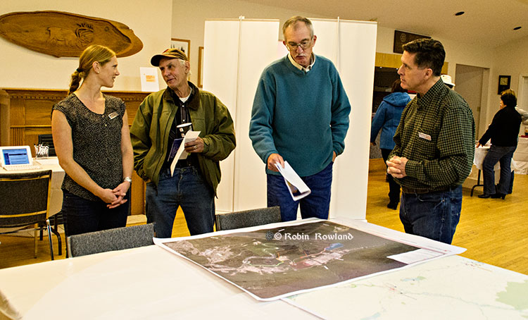
Residents of Kitimat discuss the proposed LNG Canada facility with company officials at the Rod and Gun, Nov. 27, 2013 (Robin Rowland/Northwest Coast Energy News)
LNG Canada says it wants to be “first out of the gate” in the competitive race to send BC’s liquified natural gas to Asian markets.
The company held a well attended open house at the Kitimat Rod and Gun on November 27, with the usual array of posters and experts, to mark the beginning of the environmental assessment process for what is formally called the “LNG Canada Export Terminal Project.:
The LNG Canada Export Project is a partnership of Shell,Canada Energy, Diamond LNG Canada, an (“affiliate” of Mitsubishi), Korea Gas Corporation and Phoenix Energy (an “affiliate” of PetroChina) filed a draft application for an Environmental Assessment Certificate with the BC Environmental Assessment Office and Canadian Environmental Assessment Agency on November 8. The 30-day public comment period on the draft Application Information Requirements started on November 13, 2013 and end on December 13, 2013.
The extensive documentation can be downloaded in PDF format from the BCEAO site. The documents can also be viewed at the Kitimat and Terrace Public Libraries and the LNG Canada office in Kitimat at the old Methanex site.
“What we want to be able to do is actually to provide information in a way that we can provide a lot of conversation with the community, so we can really have a dialogue, to give them a place where they know than go to get answers. We do believe that we can be the best project in British Columbia, the only way we can do that is if we have the support of the community,” LNG Canada’s Susannah Pierce told reporters.
“We would like to be first out of the gate. This is a competitive industry and we’re not just competing in terms of providing Canadian gas to the Asian markets, we’re competing with everyone else for the opportunity to deliver product to market.”
The application says that the all-important Financial Investment Decision will likely be “made mid-decade followed by 4-5 years of construction with commissioning of the first phase to follow.”
The first phase would have a first phase of about 12 million tonnes a year of LNG, with another MTPA (million tonnes per anum) in “one or two subsequent phases.”
Federal, provincial and municipal governments or agencies, First Nations and the general public have the ability to comment on the proposal.
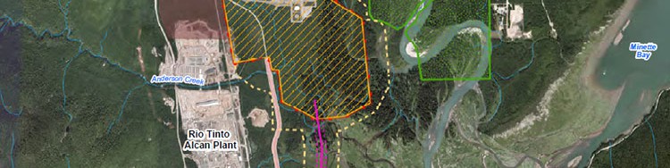
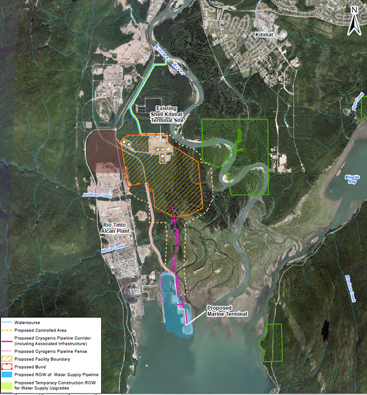
An aerial photo map included in the application shows the footprint of the proposed LNG Canada operation. Although the LNG Canada project is based at the old Methanex plant, the map shows that the LNG plant will take up a much larger area than the original. The old Methanex access road would be widened parallel to the Rio Tinto Alcan smelter and a Cyrogenic Pipeline would cross the Kitimat River estuary to the marine terminal.
A map provided by LNG Canada shows the potential footprint of the liquifaction facility and marine terminal next to the Rio Tinto Alcan aluminum smelter. (LNG Canada)
The scope of the project includes one possibly controversial item: “Onsite power generation,” where natural gas would be used to power the cooling equipment to turn the gas into LNG.
The assessment will also look the natural gas receiving and production facility; “a marine terminal able to accomodate two LNG carriers each with capacity up to 265,000 cubic metres (approximately 122,000 DWT) and a materials offloading area; supporting infrastructure and the construction facilities.
The environmental assessment will examine air quality, green house gas management, the acoustic environment (the noise created by the project), soil, vegetation, wildlife, freshwater, esturine fish and habitat, marine resources including fish and fish habitat and marine mammals, water and ground water quality.
The economic and social assessment includes infrastructure, land use, “visual quality,” odour, marine transportation and use, community health and well being, archaeological heritage and human health.
District of Kitimat Council member Mario Feldhoff discusses the LNG Canada project with a company official at the Open House at the Rod and Gun, Nov. 27, 2013. (Robin Rowland/Northwest Coast Energy News)
The assessment process will also “assess potential cumulative economic, health, social and heritage effects from the Project…interacting cumulatively with similar effects of past, present and future projects activities. The current table of projects to be considered for cumulative effects include the Rio Tinto Alcan Aluminum Smelter and Modernization Project, the Kitimat LNG and Douglas LNG terminals, the possible Enbridge Northern Gateway porject, the new use for the old Methanex and Cenovus operations, the operations at the Sand Hill, the former Moon Bay and current MK Bay Marinas.
Projects further away include LNG and other projects and associated pipelines at Prince Rupert, including expansion of the current ports and the redevelopment of Watson Island. Cruise ship and BC ferry operations will be only considered where they impact the shipping routes. Any forestry operations will also only be considered where they impact the project.
Updated to fix typos, including spelling of Feldhoff
Map released by LNG Canada shows the air shed area that the company will study as part of the environmental assessment. (LNG Canada)
Two of the maps filed by the LNG Canada project with provincial and federal environmental assessment agencies look at the air quality problems from the project, including the controversial prospect of cumulative problems from multiple industrial projects in the Kitimat Valley, one of them the RTA Kitimat Modernization Project which will increase sulphur dioxide emissions while decreasing some other emissions.
One map covers what is being called the airshed, in the case of LNG Canada, air quality will be assessed with the LNG facility at its centre. A second map covers the tanker route, and as well as a 40 km square grid around the plant that will also assess Hartley Bay, Kitkatla and Metalkatia which may be impacted by vessel emissions.
As well as scientific data, the assessment will also take into consideration traditional knowledge and traditional use from “aboriginal and other groups.”
The possible cumulative effect on the air quality in the Kitimat valley and surrounding areas has prompted the BC government to commission its own study of the Kitimat airshed.
On Oct 3, the provincial ministries of the environment and gas development announced a $650,000 scientific study “to help inform regulatory and policy development for future industrial activity in the Kitimat area. The goal is to ensure the potential impacts from industrial air emissions are clearly understood prior to new projects being approved and in operation.”
It says
The Kitimat Airshed Impact Assessment Project will look at the cumulative effects of existing and proposed industrial air emissions in the airshed. These include emissions from: an existing aluminium smelter, three proposed LNG terminals, a proposed oil refinery, a crude-oil export facility, and gas-turbine-powered electrical generation facilities. The study will focus on sulphur dioxide and nitrogen dioxide emissions from these facilities.
The study will assess the impact of emissions through a number of scenarios, including their potential effects on water and soil, as well as on vegetation and human health from direct exposure.
An airshed is generally described as an area where the movement of air (and, therefore, air pollutants) can be hindered by local geographical features such as mountains, and by weather conditions. The most obvious example in British Columbia is a mountain valley. Since air pollution knows no political boundaries, airshed activities may be focused on a single community or on a number of neighbouring communities faced with similar air quality problems and requiring similar action.
The LNG Canada assessment will look at two potential adverse effects, first a change in ambient air quality in the Kitimat airshed or along the marine access route and second any change in acidic deposition pattern in the Kitimat Valley.
The first study will look specifically at estimated levels of “criteria air contaminets” including sulphur dioxide, Nitrogen oxides, carbon monoxide, atmospheric particulate matter and hydrogen sulphide. The particulate matter study will use the international standard of 2.5 micrometres.
The assessment will also study possible cumulative effects on air quality of multiple projects and those projects over time.
LNG Canada map shows the marine and land areas that will be studying for air quality. (LNG Canada)
The Northern Gateway Joint Review panel, Kenneth Bateman, Sheila Leggett and Hans Matthews, listen to final arguments in Terrace, June 17, 2013. (Robin Rowland/Northwest Coast Energy News)
Buried deep in the LNG Canada environmental assessment application, a reader will find a key difference in attitude with at least one of the group of companies planning liquified natural gas development in the northwest and Enbridge Northern Gateway.
It’s an earthshaking difference, since it’s all about earthquakes.
The documents filed by LNG Canada with the BC Environmental Assessment Office and the Canadian Environmental Assessment Agency acknowledge that there is a possibility of an earthquake (a one in 2,475 year event) at the LNG terminal site.
Northwestern British Columbia was shaken by two major earthquakes in the months before the Joint Review Panel concluded its hearings in Terrace. Both were far from Kitimat, but felt across the District. On October 27, 2012, there was a magnitude 7.8 earthquake on the Queen Charlotte Fault off Haida Gwaii. That quake triggered a tsunami warning, although the actual tsunami was generally limited to the coast of Haida Gwaii. Both landline and mobile phone service in Kitimat was briefly disrupted by both the quake and overloads on the system. Kitimat was also shaken by the 7.5 magnitude earthquake centered at Craig, Alaska a few weeks later on January 9, 2013.
With the exception of one vague reference in its final argument documents presented to the Joint Review Panel, Enbridge has stubbornly refused to consider any seismic risk to the region.
That was the company’s policy long before the October. 27, 2012 Haida Gwaii earthquake and was Enbridge policy after October 27, 2012.
In a public meeting in Kitimat on September 20, 2011, more than a year before the Haida Gwaii earthquake, John Carruthers, Northern Gateway president, insisted to skeptical questioners at a community forum at Mount Elizabeth Theatre that there was no earthquake danger to the proposed Northern Gateway pipeline and bitumen terminal in Kitimat. One of the questioners, Danny Nunes, of Kitimat, asked could the pipes withstand an earthquake? Carruthers repeated that Kitimat was not in an earthquake zone, that the fault was off Haida Gwaii and so would not affect Kitimat.
After the September, 2011 meeting, I asked Carruthers if Enbridge knew about the March 27,1964 “Good Friday” magnitude 9.2 Alaska earthquake that, because of its high magnitude, had caused major shaking in Kitimat. That earthquake destroyed much of Anchorage and triggered tsunamis that caused damage and death across Alaska and in parts of British Columbia, Oregon and California.
Carruthers promised to get back to me and never did.
On June 17, 2013, six months after the Craig, Alaska earthquake, in his opening summation before the Joint Review Panel, Richard Neufeld, lead lawyer for Northern Gateway, stayed on message track, telling the JRP, referring to pipelines: “The route is not seismically unstable. The seismic risk along the pipeline right-of-way is low, with only a few locations of moderate risk encountered, none of which are within the Haisla territory.”
That brought a gasp from spectators in the room, or at least those who had felt the October and January earthquakes.
The following day, June 18, Murray Minchin of Douglas Channel Watch found an anomaly in the Enbridge documentation, arguing in the group’s summation:
“The Proponent’s written final argument gets on shaky ground regarding design and construction of the storage tanks on a ridge beside Douglas Channel in paragraph 249 where they say:
“‘It also involves the safe construction and operation of the Kitimat terminal in Kitimat Arm in an area subject to seismic activity which encompasses both terrestrial and marine components.’
“Now, that’s interesting because isn’t that the first time — the first admission by the Proponent in a little over 10,000 pages of documents that the area they intend to build their project is in a seismically-active area?
“Haven’t they been telling us all along to this point that the only seismic concerns would be from the distant Queen Charlotte fault off of Haida Gwaii?
“Now, this completely contradicts Mr. Neufeld’s statement yesterday where he described the Project area as not “seismically unstable”. So what is it? This is their final argument and they’re contradicting themselves.”
Minchin went on to quote from the Enbridge argument: “’Seismic conditions in the project area have also been addressed.’
“Well, really? Is that a truthful statement, considering Natural Resources Canada has only submitted a preliminary report concerning a 50-kilometre fault line and massive submarine landslides they accidentally discovered last year in Douglas Channel while doing a modern survey of the Channel for navigation hazards.
“How can the Proponent claim to have adequately addressed seismic forces in their design of this Project when they don’t know what those forces are or for what duration they may be subjected to those forces.
“Has there ever been a paleoseismological study in the Project area to establish past earthquake or tsunami history?
“Wouldn’t it be in the best interest of the Proponent, the Panel and Canadians to know the risks before 1.3 billion litres of liquid petroleum products are allowed to be stored on a low ridge right beside Douglas Channel?”
In his final rebuttal on June 24, Neufeld did not address the contradictions that Minchin had pointed out.
Compare Enbridge’s attitude to the view of LNG Canada, which at very least, appears willing to consider that major events could have adverse consequences on the terminal and liquifaction facilities.
The first one is a bit puzzling to Kitimat residents “A 1 in 100 year 24 hour rain event,” after all the town often gets rain for 24 hours straight or more fairly often.
The second, 1 in 200 year flood of the Kitimat River. Flooding has always been a concern and will be even more so, because as the pipelines come into town, whether natural gas or bitumen, those pipelines will be close to the river bank.
Even more interesting is that LNG Canada is willing to consider possible effects of climate change on the project, saying: “Predicted climate change effects during the project lifecycle on sea-level rise, precipitation and temperature. Where relevant and possible, the implications of such climate induced changes to the extreme weather events given above will also be addressed.”
.
Although the hydrocarbon industry as a whole is reluctant to acknowledge climate change, it appears that on a practical level, the LNG Canada partners, if they are about to invest billions of dollars in a natural gas liquifaction plant and marine terminal, will certainly take steps to protect that specific investment from the effects of climate change.
On the other hand, the National Energy Board, as matter of policy and the Northern Gateway Joint Review Panel, both still stubbornly refuse to even consider any effects of climate change, even possible effects locally on a specific project application.
The Joint Review Panel decision on the Northern Gateway is expected sometime in the next three weeks. While most reports seem to indicate that the decision will be released after Christmas before the Dec. 30 deadline, there has been recent media speculation that the decision could be released next week.
The problem for Enbridge is that the new public relations campaign is repeating the blunders that began when they first proposed Northern Gateway in 2005. There have been meetings across the northwest, but those meetings have been invitation only affairs at chambers of commerce and community advisory boards, with possible opponents or skeptics and media perceived as critical of Enbridge not invited. So Enbridge still wants to control the message and will only talk to friendly gatherings.
Then there are the television spots featuring Janet Holder, the Enbridge vice president in charge of Northern Gateway, supposedly showing her commitment to wilderness. Those commercials would have had more credibility if the agency had produced the ads with actual video of Holder walking through the bush, rather than shooting the spots in front of a green screen in a studio, with pristine wilderness stock video in the background, and Holder acting as if she was a model for an adventure clothing company rather than vice president of a pipeline company.
Right-wing business columnists in Toronto and the countless Albertans fume at the so-called “hypocrisy” of British Columbians who support LNG and oppose bitumen.
Of course, those critics didn’t feel the earth move under their feet. The critics don’t see the difference between natural gas and bitumen, differences very clear to the people of British Columbia.
It’s more than the fact, that so far, the LNG projects have been relatively open and willing to talk to potential adversaries, as Chevron has done on the controversial Clio Bay project; more than the fact that if even a fraction of the LNG projects go ahead, the money coming into northwestern BC means that the handful of permanent jobs promised by Enbridge will be literally a drop in a bucket of warm bitumen.
Although there are many other environmental issues on the Northern Gateway project, the fact the potential for earthquakes in Kitimat is brushed off by Enbridge while LNG Canada is at least willing to consider the problem, sums it all up.
Updated with link to Sept. 2011 questions and answers
BC Parks and the Gitga’at First Nation are calling for public input as they development a management plan for the K’nabiyaaxl/Ashdown Island Conservancy at the mouth of Douglas Channel.
BC Parks describes the area as:
K’nabiyaaxl/Ashdown Conservancy covers 727 hectares of marine and uplands ecosystem on the northwest coast of British Columbia, south of Gil Island. The conservancy is 40 kilometres south of Hartley Bay and 120 kilometres southwest of Kitimat. The conservancy is in the traditional territory of the Gitga’at First Nation.
Although not well known outside the Kitimat region, Ashdown Island did receive some measure of fame because it was one of the islands that disappeared from Enbridge’s promotional animation of the tanker route for diluted bitumen from Kitimat to Asia if the controversial Northern Gateway project goes ahead. As well as a haven for wildlife, Ashdown is known as a prime halibut fishing area.
Ashdown Island study area (BC Parks)
Ashdown Island is on the proposed “Southern Approach” for Enbridge’s tanker traffic routes.
The area and nearby waters have been and continue to be intensively used by the Gitga’at people for cultural, social and economic purposes. In Tsimshian language (Sm’algyax), K’nabiyaaxl means “place where cliff” – which is located on the west side of Ashdown Island.
The conservancy encompasses all of Ashdown Island and the foreshore area
and land covered by water within 200 metres of the high tide line. It
has high intertidal values, especially for seaweed, and contains an important
Steller Sea Lion haulout. The waters around the island support important Gitga’at
community fisheries.
Although in Gitga’at traditional territory, the plan notes that the Haisla, the Kitasoo community of Klemtu; and Gitxaala community of Kitkatla on Dolphin Island should be consulted.
It goes on to say:
The conservancy protects an entire small island representative of the Hecate Lowlands Ecosection. The island’s foreshore marine environments include high value intertidal areas which provide high value habitat for important marine wildlife species and migratory birds. The conservancy also protects a haulout for Stellar Sea Lions (Eumetopias jubatus), a species of concern (provincially blue- listed3)…
Stellar Sea Lions use small islets off the south end of Ashdown Island as a winter
haulout, with up to 12 pups and 107 adults observed
The plans lists the Humpback Whale (Blue-listed, S1N); the. Killer Whale (Red- or Blue-listed, S2 or S3 depending on sub-species); and the Fin Whale; as Ashdown Island species at risk. (SARA species schedule procedure site)
As well:
The conservancy contains seven hectares of potential Marbled Murrelet habitat
which, although small, may provide important habitat when combined with core
Marbled Murrelet habitat in nearby areas.
K’nabiyaaxl’s remote location provides an excellent opportunity for maintaining
biological diversity and natural environment values. This habitat should not be
disturbed by conservancy use and development.
The island and the near shore are also part of the Gitga’at’s rich cultural heritage.
The conservancy is near the seasonal Gitga’at village camp of K’yel. The Gitga’at
travel in the spring from Hartley Bay to K’yel, which they use as a base for conducting intensive marine and intertidal harvesting and hunting activity.
Since time immemorial, the Gitga’at people have harvested fish and marine
mammal species in waters adjacent to K’nabiyaaxl. They also collect seaweed,
plants and berries from intertidal and upland areas on the island.
Archaeological sites are known to exist in the area. That the BC Archaeological
Branch does not have archaeological sites registered in the conservancy is not
indicative of the rich history of Gitga’at occupancy and use of K’nabiyaaxl.
A second floating liquified natural gas terminal may be planned for Kitimat, Northwest Coast Energy News has learned.
According to multiple sources in Kitimat, Altagas, the parent company of Pacific Northern Gas plans the terminal at the old log sort site on Douglas Channel, where the barge carrying the liquifaction equipment would likely be moored next door to the already planned BC LNG/Douglas Channel Partners LNG project which would be served by gas delivered by the PNG pipeline system.
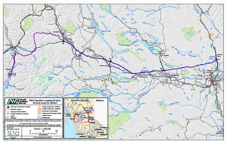
Pacific Northern Gas has filed an application with the BC Environmental Assessment Office to construct and operate an approximately 525 kilometre, 610 millimetre (24 inch) diameter natural gas pipeline from the natural gas hub at Summit Lake, near Prince George, to Kitimat that would loop or twin the existing PNG existing natural gas pipeline.
The application to the BCEAO says: “The proposed Project would supply natural gas to proposed liquefied natural gas (LNG) export facilities as well as the Proponent’s existing customers. The proposed Project would include the replacement of four existing compressor stations and would have an initial capacity of 600 million standard cubic feet per day.”
PNG Pipeline Looping Project Open House at Tamitik. Nov. 26, 2013. (Robin Rowland/Northwest Coast Energy News)
On Tuesday, November 26, Pacific Northern Gas held a sparsely attended open house at Tamitik Arena as part of the BCEAO public comment procedure.
A 38 day public comment period on the application information requirements started on November 25 and will end on January 2, 2014.
At the open house, PNG officials explained that “looping” means that there would be a second or twin pipeline that would mostly be on a parallel route to the existing pipeline. Since both pipelines would begin at the Summit Lake terminal and end at the Kitimat terminal that is where the term “looping” comes in.
The PNG officials said that the pipeline was initially designed to service the first floating LNG terminal at the old log sort site on Douglas Channel south of Kitimat, but north of the KM LNG site at Bish Cove.
It would be operated by BC LNG Energy Cooperative, through Douglas Channel Energy Partnership, a partnership with the Haisla Nation and LNG Partners, the energy investors mainly from Texas,
Unlike the bigger project Kitimat LNG or KM LNG, a partnership between Chevron and Apache (and according to reports possibly Sinopec) or the Shell-led partnership LNG Canada, the BC LNG project would allow smaller companies to provide LNG to Asian customers.
At the open house, the PNG officials said the two pipelines could also service “another Kitimat floating LNG project” but declined to give details for confidentiality reasons. The same officials also said the proponent of that project was also looking at Prince Rupert as a possible site for the second floating terminal.
Kitimat sources have confirmed that AltaGas has told them that the company is also considering Prince Rupert as a site for a floating LNG terminal.
However, the current documentation and maps filed with the BCEAO show the PNG looping pipeline terminating at Kitimat, not Prince Rupert.
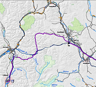
Detail of the PNG Pipeline Looping proposal. The existing pipeline is shown at the dashed line, the new pipeline is shown in purple. (PNG)
According to the maps filed with the BCEAO and made available at the open house, the new pipeline would not be twinned completely along the existing route across the mountains west of Smithers to Terrace, but would head north at Telkwa parallel to Highway 16 before making its own way through the mountains, crossing the existing pipeline at the Zymoetz River east of Terrace and then taking a westerly route toward Lakelese Lake before joining the existing pipeline corridor along Highway 37. AltaGas took over Pacific Northern Gas in the fall of 2011.
The problems currently faced by the Texas group have no affect, at this point, on the Haisla Nation investment in the BC LNG Energy Cooperative. There is already speculation in Kitimat that if the LNG Partners get into further financial difficulty, AltaGas may step in and take over. The would raise the question whether or not there would still be two floating LNG terminals on Douglas Channel, or just the one, as originally planned, but under new ownership.
In it’s project proposal PNG says
The Project will generate approximately 1800-2400 direct person years of employment during construction. Additionally, tax benefits will be generated for Kitimat and the regional districts crossed by the pipeline. PNG anticipates the project will also result in a significant reduction in natural gas transportation rates for its existing customers.
Natural gas transportation costs are a major issue in the northwest, for those costs appear to keep going up while the price of natural gas in North America is generally going down. Natural gas transportation costs in Kitimat spiked after the closure of the Methanex plant and have continued to be quite high, which is just one of the increasing burdens for residents of Kitimat on fixed or low incomes, who are not benefiting as others from the current boom town economy.
The PNG filing with the BCEAO promises consultation with both the Wet’suwet’en Council, and the Office of the Wet’suwet’en, which represents the hereditary chiefs and matriarchs, as well as other First Nations along the proposed route.
PNG Open houses for the project are scheduled for:
Vanderhoof
Friendship Centre Hall
Thursday, November 28, 2013
Terrace
Best Western Inn
Monday, December 2, 2013
Smithers
Hudson Bay Lodge
Tuesday, December 3, 2013
Burns Lake
Chamber of Commerce
Wednesday, December 4, 2013
Summit Lake
Community Hall
Thursday, December 5, 2013