In a two to one decision, the Federal Court of Appeal has overturned the Harper government’s approval of the Enbridge Northern Gateway Pipeline, finding that the federal government’s consultation process with First Nations on the BC coast that occurred after the NEB decision and the Joint Review Panel Report was inadequate, saying:
We conclude that Canada offered only a brief, hurried and inadequate opportunity in Phase IV—a critical part of Canada’s consultation framework—to exchange and discuss information and to dialogue. The inadequacies—more than just a handful and more than mere imperfections—left entire subjects of central interest to the affected First Nations, sometimes subjects affecting their subsistence and well-being, entirely ignored.
The dissenting judge found that the federal government under Stephen Harper had adequately consulted the First Nations. The split decision means that one of the parties, either the federal government, Enbridge Northern Gateway or the Canadian Association of Petroleum Producers may seek leave to appeal to the Supreme Court of Canada.
The Environmental Protection Division of BC’s Ministry of Environment is launching a major study of the water quality in the Kitimat valley, first on the Kitimat River and some of its tributaries and later on the Kitimat Arm of Douglas Channel.
There has been no regular sampling by the province in Kitimat since 1995 (while other organizations such as the District of Kitimat have been sampling).
Jessica Penno, from the regional operations branch in Smithers, held a meeting for stakeholders at Riverlodge on Monday night. Among those attending the meeting were representatives of the District of Kitimat, the Haisla Nation Council, LNG Canada, Kitimat LNG, Rio Tinto BC Operations, Douglas Channel Watch, Kitimat Valley Naturalists and the Steelhead Society.
As the project ramps up during the spring and summer, the ministry will be looking for volunteers to take water samples to assist the study. The volunteers will be trained to take the samples and monitored to insure “sample integrity.” Penno also asked the District, the Haisla and the industries in the valley to collect extra samples for the provincial study and to consider sharing historical data for the study.
With the growing possibility of new industrial development in the Kitimat valley, monitoring water quality is a “high priority” for the province, Penno told the meeting. However, so far, there is no money targeted specifically for the project, she said.
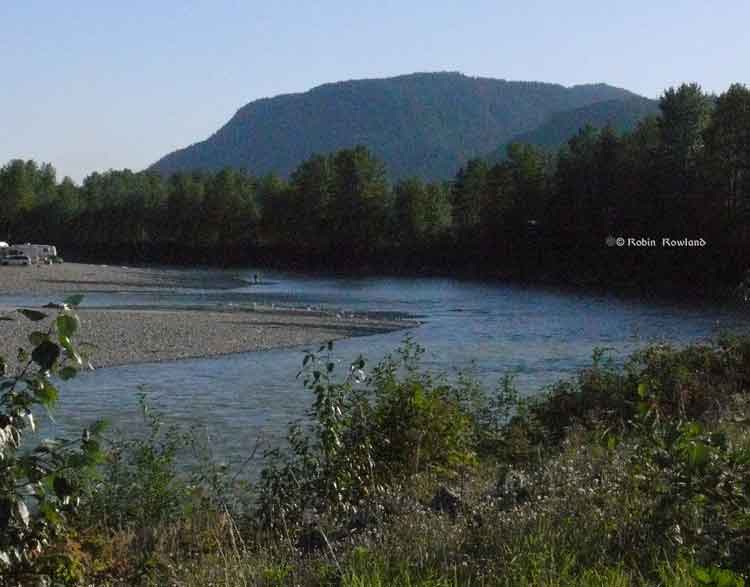
Camping and fishing on the Kitimat River. (Robin Rowland/Northwest Coast Energy News)
The purpose of the study is to make sure water in the Kitimat valley meet the provinces water quality objectives, which have the aim of watching for degradation of water quality, upgrade existing water quality or protect for designated uses such as drinking water, wildlife use, recreational use and industrial water supplies as well as protecting the most sensitive areas. It also provides a baseline for current and future environmental assessment. (In most cases, testing water quality for drinking water is the responsibility of the municipalities, Penno said. The province may warn a municipality if it detects potential problems, for example if a landslide increases metal content in a stream).
Under the BC Environment system, “water quality guidelines” are generic, while “water quality objectives” are site specific.
One of the aims is to compile all the studies done of the Kitimat River estuary by the various environmental impact studies done by industrial proponents.
The ministry would then create a monitoring program that could be effectively shared with all stakeholders.
At one point one member of the audience said he was “somewhat mystified” at the role of Fisheries and Oceans in any monitoring, noting that “when you phone them, nobody answers.”
“You mean, you too?” one of the BC officials quipped as the room laughed.
Water quality objectives
The last time water quality objectives were identified for the Kitimat River and arm were in the late 1980s, Penno told the meeting. The objectives were developed by the British Columbia government because of potential conflict between fisheries and industry at that time. The objectives were developed for the last ten kilometres of the Kitimat River and the immediate area around the estuary and the Kitimat Arm. “The Kitimat is one of the most heavily sport fished rivers in Canada,” she said.
However, the work at that time was only provisional and there was not enough water quality monitoring to create objectives that could be approved by the assistant deputy minister.
There has been no monitoring of the Kitimat River by BC Environment since 1995. “We’ve had a lot of changes in the Kitimat region, with the closure of Methanex and Eurocan, the modernization of Rio Tinto and potential LNG facilities.”
The main designated uses for the Kitimat River at that time were aquatic life, wildlife with secondary use for fishing and recreation.
She said she wants the stakeholders to identify areas that should be monitored at first on the river and the tributaries. Later in the summer, Environment BC will ask for suggestions for the estuaries of the Upper Kitimat Arm.
Participants expressed concern that the water supply to Kitamaat Village and the Kitimat LNG site at Bish Cove as well as Hirsch Creek and other tributaries should be included in the study. Penno replied that the purpose of the meeting was to identify “intimate local knowledge” to help the study proceed.
After a decade so of cuts, the government has “only so much capacity,” Penno said, which is why the study needs the help of both Kitimat residents and industry to both design the study and to do some of the sampling.
The original sampling station in the 1980s was at the Haisla Boulevard Bridge in Kitimat. A new sampling station has been added at the “orange” Kitimat River bridge on Highway 37. There is also regular sampling and monitoring at Hirsch Creek. The aim is to add new sampling points at both upstream and downstream from discharge points on the river.
The people at the meeting emphasized the program should take into consideration the Kitimat River and all its tributaries—if budget permits.
Spring freshette
Last year, the team collected five samples in thirty days in during four weeks in May and the first week in June, “catching the rising river quite perfectly” at previously established locations, at the Haisla Bridge and upstream and downstream from the old Eurocan site as well as the new “orange bridge” on the Kitimat River.
The plan calls for five samples in thirty days during the spring freshette and the fall rain and monthly sampling in between.
The stakeholders in the meeting told the enviroment staff that the Kitimat Valley has two spring freshettes, the first in March during the valley melt and later in May during the high mountain melt.
The plan calls for continued discussions with the industry stakeholders, Kitimat residents and the Haisla Nation.
The staff also wants the industrial stakeholders to provide data to the province, some of it going back to the founding of Kitimat if a way can be found to make sure all the data is compatible. One of the industry representatives pointed out, however, that sometimes data is the hands of contractors and the hiring company may not have full control over that data.
There will be another public meeting in the summer, once plans for sampling in the Kitimat Arm are ready.
Eel grass is not a seaweed but a flowering plant that migrated to the sea, say scientists who have now mapped the eel grass genome. The study also shows that eel grass ( Zostera marina) is crucial in absorbing carbon dioxide in the soft sediments of the coasts.
Eel grasses form a carbon dioxide sink: “they store more carbon than tropical forests,” says Jeanine Olsen of the University of Groningen in the Netherlands who led the study.
Coastal sea grass ecosystems cover some 200,000 square kilometers, the study says. Those ecosystems account for an estimated 15 per cent of carbon fixed in global ocean, and also impact sulphur and nitrogen cycles.
The scientists argue that since sea grasses are the only flowering plants to have returned to the sea that is the most extreme adaptation a terrestrial (or even freshwater) species can undergo.
The science team says the Zostera marina genome is “an exceptional resource that supports a wide range of research themes, from the adaptation of marine ecosystems under climate warming and its role in carbon burial to unraveling the mechanisms of salinity tolerance that may further inform the assisted breeding of crop plants.”
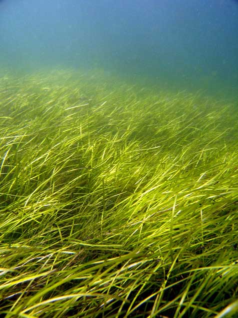
A seagrass meadow. (Christoffer Boström)
Sea grasses form the backbone of one of the most productive and biodiverse ecosystems on Earth, rivaling coral reefs and rain forests in terms of the ecosystem services they provide to humans.
Sea grass meadows are part of the soft-sediment coastal ecosystems found in all continents, with the exception of Antarctica. They not only form a nursery for young fish and other organisms, but also protect the coastline from erosion and maintain water clarity. ‘
The study, which sequenced the genome of the eel grass taken from the Archipelago Sea off Finland. published today, in the journal Nature, is the work of an international consortium of 35 labs, most of them in Europe, working with researchers from the U.S. Department of Energy Joint Genome Institute.
The study showed that eel grasses are completely submerged marine flowering plants, called by science angiosperms. It shows that eel grass is a member of the ancient monocot family.
The monocots include about 60,000 species, flowering plants that first appear above the soil as a single leaf. They include orchids, “true grasses,” as well as rice, wheat, maize and “forage grasses” such as sugar cane, and the bamboos. According to Wikipedia, other economically important monocot crops include palms bananas , gingers, onions, garlic, lilies, daffodils, irises, amaryllis, bluebells and tulips.
Zostera marina is the first marine flowering plant have its genome fully sequenced. As well as finding the eel grass’s genetic ancestors the researchers were interested in understanding how the plant–and by extension other plants in the ecosystem–adapt to climate change.
As it adapted to an underwater, coastal lifestyle, eel grass gained genes that allowed it to live in saltwater but lost genes involved in traits associated with land-based plants.
Olsen called this “arguably the most extreme adaptation a terrestrial (and even a freshwater) species can undergo.”
What she describes as the “use it, lose it, or change it” scenario, eelgrass modified its cell walls. The eel grass cell wall is very different from normal plant cell walls and more like that of sea algae, similar to the cell in seaweeds. The eel grass has lost genes associated with light-sensing, pollination and regulation of internal water balance.
Eel grass lost its stomata (which are used by land plants to ‘breathe’) but also all of the genes involved in stomatal differentiation. “The genes have just gone, so there’s no way back to land for sea grass,” Olsen says. Sex is entirely underwater involving long naked sperm filaments especially adapted for underwater fertilization of the tiny flowers.
The team compared the eel grass genome to duck weed, one of the simplest flowering plants and Zostera marina’s closest sequenced relative. They noted differences in genes related to cell wall structure due to adaptations to freshwater or terrestrial conditions. For example, plants such as duckweed have seemingly lost genes that help plants retain water in the cell wall, while eel grass has regained these genes to better deal with osmotic stress at low tide.
“They have re-engineered themselves,” said Olsen of the changes affecting the eelgrass cell walls. “Crop breeders may benefit from lessons on how salt tolerance has evolved in these plants.”
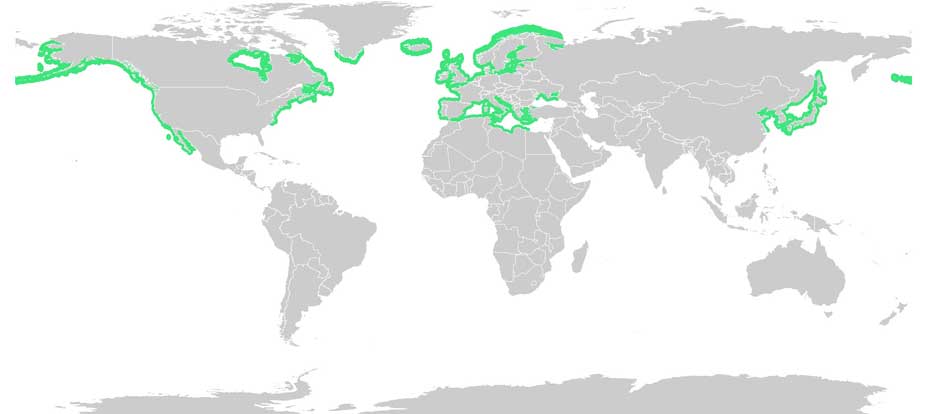
Eel grass distribution. (Wikipedia Commons(
With Zostera marina meadows stretching from Alaska to Baja California, and from the White Sea to southern Portugal, Olsen noted that these ecosystems afford researchers “a natural experiment to investigate rapid adaptation to warmer or colder waters, as well as to salinity tolerance, ocean acidification and light.”
Eel grass endangered
Jeremy Schmutz, head of the US Department of Energy’s genetic plant program, emphasized that while eel grasses are key players in coastal marine ecosystem functions and considered the “lungs of the sea,” they are also endangered. “There are estimates that nearly a third of the eel grass meadows worldwide have been destroyed by runoff into the ocean,” he said, “reducing their potential capabilities as carbon sinks. Thus, studying the adaptive capacity of eel grass is urgent to assist conservation efforts.”
An overarching question for Olsen’s team is how quickly eel grass can adapt to rapid climate change. The fact that Zostera marina grows along the coastline from Portugal to Scandinavia is being used as a natural experiment to investigate adaptation to warmer or colder water, as well as to salinity, ocean acidification and light.
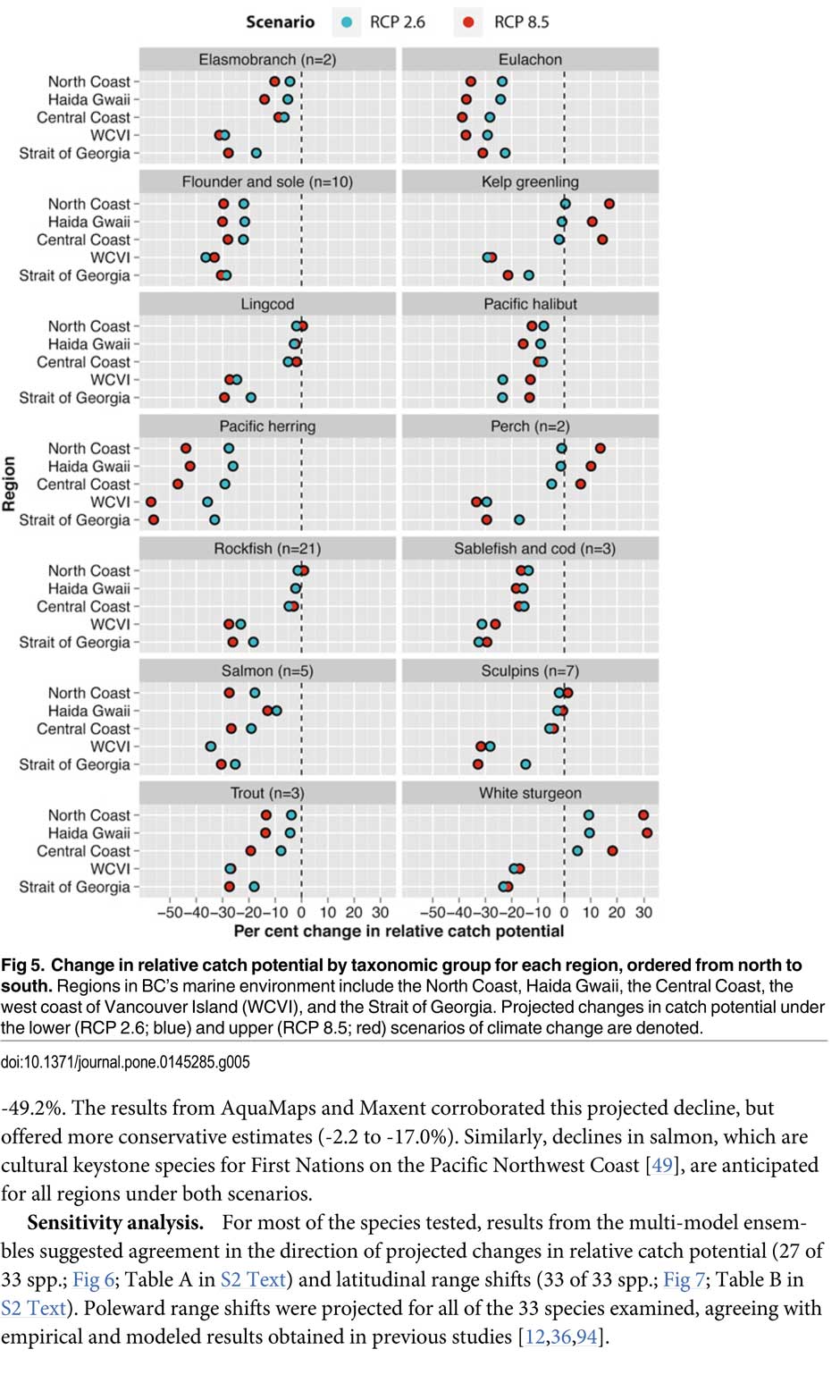
That’s one of the predictions from a new study from the University of British Columbia, looking at the future of the fishery on the coast.
The study concentrates on the First Nations fishery and warns that aboriginal people could face a catastrophic decline in the harvest of traditional species, especially salmon and herring roe on kelp over the next thirty years, a decline that will also have an equally devastating effect on commercial and recreational fishing.
The main cause of the decline is climate change and the warming of the coastal waters. The study projected “modest to severe declines in catch potential” for all current commercial fisheries along the coast.
The study says that for the First Nations the between $28 million to $36 million in revenue they got from fishing between 2001 and 2010 could fall by up to 90 per cent depending on how the climate changes.
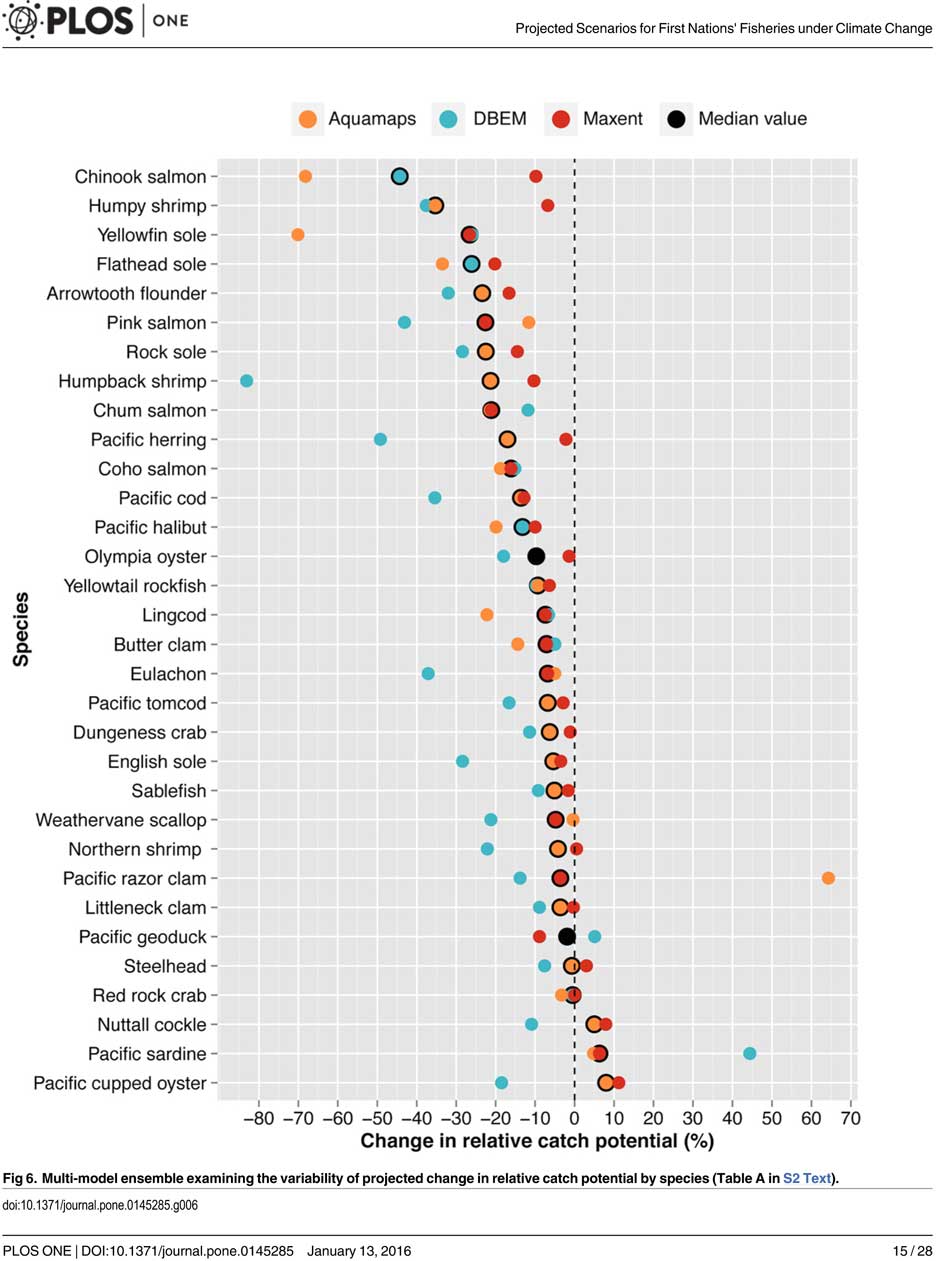
A chart from the UBC study shows possible decline in fish species under different climate scenarios. (PLOS1)
One scenario calls for a decline of up to 40 per cent in chinook and pink salmon.
If there is any good news, if you can call it that, the decline will be not as bad in northern coastal waters as it will be the warmer waters near the Lower Mainland and southern Vancouver Island. The range of some species, including salmon, herring, halibut and possibly oolichan will move to farther north along the BC Coast and into Alaskan waters.
That means in time the warming waters will also encourage an increase in other species, including sardines and some clams.
The changing oceans mean that “an increase in the relative abundance of warmer-water species was projected to lead to new or increased opportunities for commercial harvests by 2050.”
The study is urging the First Nations and other stakeholders in the British Columbia fishery to start long term planning immediately to anticipate changes in the coming decades.
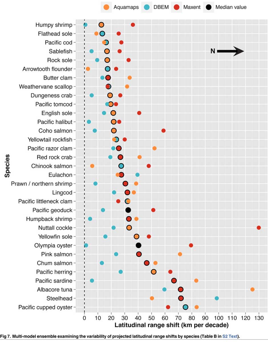
The team of scientists led by Lauren Weatherdon, a graduate student at UBC, noted that while previous studies have looked at the impact of climate change on large-scale commercial fisheries, “few efforts have been made to quantitatively project impacts on small-scale subsistence and commercial fisheries that are economically, socially and culturally important to many coastal communities.”
The study was conducted in cooperation with the BC First Nations Fisheries Council and looked its seven coastal administrative regions “forming a sample of groups with diverse marine resources, geographical locations, territorial sizes, and treaty statuses.”
Within those regions 16 First Nations participated in the study, some under their treaty councils, including the Council of the Haida Nation, the Tsimshian Nations Treaty Society (including the Gitga’at at Hartley Bay and the Kitselas and Kitsumkalum near Terrace) and the Maa-nulth First Nations. The Heiltsuk First Nation at Bella Bella participated as an independent group.
The FNFC’s administrative regions intersect with five distinct ecological regions: the North Coast, comprising the Hecate Strait and Dixon Entrance; Haida Gwaii, which includes the waters surrounding the islands; the Central Coast, including Queen Charlotte Sound, Queen Charlotte Strait, and the southern tip of Hecate Strait; the Strait of Georgia; and the west coast of Vancouver Island (WCVI) .
The study says First Nations are likely to be exposed to different climate-related impacts on fisheries due to the differing ecological and biogeographical characteristics of these regions and to differing traditional and commercial harvests.
The study used a “dynamic bioclimate envelope” computer model to look at the changes to the distribution and relative abundances of the BC coastal species under two climate change scenarios, a high greenhouse gas model where society can’t curb emissions and a low greenhouse gas emission scenarios, depending on how society is able to curb the increase.
The study looked at ocean properties—including sea surface temperature, sea bottom temperature, salinity, oxygen concentration, surface action, and net primary production—using data from the US National Ocean and Atmospheric Administrations’ climate-related earth system model.
Climate change will mean that current species on the BC coast will “shift polewards.”
The study showed that by 2050, there could be declines in 87 of the 98 species in the study.
Greater losses in what the study calls “species richness” is likely to occur towards the southern coast of British Columbia, falling primarily between 48°N and 51°N. But, overall, species richness along coastal BC will continue—only with different species.
Most significantly the study projects a decline in the overall salmon catch from 17.1 per cent to 29.2 per cent, depending on the region and climate.
All aspects of the herring fishery, including roe herring, spawn-on-kelp, and the food and bait fishery could decline between 28.1 per cent and 49.2 per cent depending on the region.
The future of the oolichan is the most uncertain. One of the models studied projected a further 37.1 per cent decline in the oolichan, while other models called for for a decline between 5 per cent and 6.8 per cent. That will depend on how well, the oolichan already threatened in most regions of British Columbia are able to adapt to warmer waters or find a way to move their range northward.
The study says white sturgeon and Pacific sardines were projected to increase in abundance under both climate change scenarios, while manila clams were projected to increase in abundance by 14.5 per cent in one of the models. The eight remaining species showed little change.
The study suggests that the southern territories (Tsawwassen, Tla’amin, and Maa-nulth First Nations) will likely see a reduction in catch potential between -15.2 per cent and -27.8 per cent depending on how the climate changes.
On the north coast. The Haida and Tsimshian First Nations and those situated along the central or north-eastern coasts of Vancouver Island (Heiltsuk and ‘Namgis First Nations) would likely see smaller reductions in relative catch for each territory, with estimates falling between -3.2 per cent and -8.2 per cent.
The study shows that for the First Nations along the North and Central Coasts of British Columbia (Gitga’at and Haida, and Heiltsuk and ‘Namgis) there will be neutral or positive shifts in catch potential for white sturgeon, kelp greenling, and two species of perch under both scenarios.
While varying regionally, both scenarios also suggested either a slight cumulative decline or negligible change in catch potential for clams, rockfish, lingcod, and sculpins across the North and Central Coast.
One potential problem the study suggests is that fishers in southern British Columbia may, in the future, try to move north to follow the harvest, leading to potential conflicts. The cost of travel, may, however, discourage that.
One of the recommendations from the study is that First Nations revive the traditional clam gardens.
Traditional clam beds serve as an ideal example of a method that could be applied to offset climatic impacts through internalized mechanisms, using local cultivation to generate increased productivity by enhancing native habitat rather than redirecting extraction efforts towards other regions or species. Clam gardens constructed in a manner akin to those situated near ancient settlements of the Northern Coast Salish and Laich-kwil-tach First Nations have been found to generate higher clam densities, biomass, and growth rates than non-walled beaches . These benefits were observed for Pacific littleneck clams and butter clams , two clams that are of cultural, economic, and ecological importance to the region Reinstating clam beds in First Nations’ territorial lands has been suggested as a means of simultaneously achieving local conservation and cultural objectives and may thereby provide a politically and ecologically viable option for mitigating climate-related impacts.
The most important recommendation is that the First Nations and other stakeholders start cooperating immediately to offset how the changing climate with affect the fishery:
Management of salmon and herring stocks has been highly contentious due to the myriad of stakeholders who depend upon them, which include First Nations, recreational fisheries, and commercial fisheries….
Aside from fulfilling societal needs, salmon serve as key ecological components of the Pacific Northwest Coast, functioning as the mechanisms by which nutrients are transferred from the ocean to freshwater and terrestrial ecosystems
It says the projections show that a “redistribution of fishing effort” will not “fully offset declines in salmon and herring”
attaining a state of collaboration between First Nations, DFO, and other sectors has the potential to yield beneficial ecological and political results, if implemented correctly. Parallels exist between First Nations’ traditional fisheries management approaches and “modern” approaches (e.g., spatial management, mariculture, selective fishing, fishing closures), with differences arising primarily due to diverging worldviews.
It recommends local application of First Nations’ traditional management strategies to “provide opportunities to collaboratively engage in adaptive ecosystem-based management and to coordinate efforts to attain conservation objectives.”
They give an example of how the Nisga’a Nation have ensured their equal partnership in management by employing traditional fish wheel technology to monitor and assess stocks and by leveraging traditional ecosystem-based management practices that could be applied to plan long-term objectives and management approaches.
It concludes by saying that joint-management will not only work to reduce the impact of climate change but also head off potential conflict.
Through such joint-management regimes, traditional fisheries management strategies could be applied to advance localized research directives and to reduce impacts on stocks under unprecedented environmental change. Moreover, the risk of conflict over declining resources underlines the need to establish common and equitable ground to ensure successful joint management of fisheries, and to leverage collective expertise.
Chart from the study showing which fish species will move north up the coast as the climate changes. (PLOS1)
The British Columbia Environmental Appeal Board has upheld Rio Tinto’s plans for sulphur dioxide emissions in the Kitimat airshed and dismissed the appeal from residents Emily Toews and Elisabeth Stannus.
The 113 page decision was released by the EAB late on December 23. It contains a series of recommendations for further studies and monitoring of the health of Kitimat residents. In effect, the EAB is asking the province (which is all it can do) to spend money and create a new bureaucracy at a time when Kitimat’s medical community is already short staffed and under stress.
By December 31, 2016…. engage with Ministry executive to secure their support for, and action to encourage, a provincially-led Kitimat region health study, based on the development of a feasibility assessment for such a study.
On December 24, Gaby Poirier, General manager – BC Operations
Rio Tinto, Aluminium Products Group released a statement saying:
Based on the evidence and submissions made by each of the parties, the EAB confirmed our permit amendment.
Although it is welcome news for Rio Tinto that the MOE Director’s decision was upheld, and the rigor and cautious approach of the science were confirmed by the EAB, we also recognize that there is more work to do to address community concerns regarding air quality in the Kitimat Valley.
In providing their confirmation, the EAB included a series of recommendations. Over the coming months, we will be working to fully assess them and we will continue to involve the local community including residents, stakeholders and our employees as we do so, noting that some of the recommendations have already started to be implemented.
I would like to take this opportunity to thank the residents of Kitimat, our valued stakeholders and our employees for their support during this process. At Rio Tinto, we are committed to protecting the health and well-being of our employees, the community, and the environment as we modernize our BC Operations.
The District of Kitimat in an update on the boil water advisory says it could last until the end of the week. There is no immediate problem because the water is still being treated.
Kitimat Chief Administrative Officer Warren Waycheshen says the turbidity from the high water means that it is not possible to do a full sample on the safety of the water. There are no delays due to the holiday weekend, the labs are open and ready, Waycheshen told Northwest Coast Energy News.
There are no immediate dangers to Kitimat from the high water, he said.
October 11, 2015
The boil water advisory issued by the District of Kitimat will remain in place at this time. Until further notice, continue to boil water for 2 solid minutes before using it for cooking or drinking.
The District of Kitimat, with advice from Northern Health, will not consider terminating the advisory until two samples conclude there is not a health risk. Sampling is not expected to be complete until at least the end of the week of October 12, 2015 and could be longer if the rain continues.
The District is treating the water as usual. There is nothing to suggest contamination is occurring; however, as a precautionary measure please continue to boil water prior to use.
Turbidity in this case means high levels of particulate matter in the river, including sand and possibly salts. Waycheshen said the Kitimat River rose four metres on Saturday, then dropped by about two metres overnight but with the later Sunday afternoon rain the river is rising once again.
The Environment Canada forecast issued at 4 pm Sunday, calls for rain for the next week.
Rain. Amount 15 to 25 mm. Windy. Temperature steady near 8.
Night
Showers. Windy early in the evening. Temperature steady near 8.
Tue, 13 Oct
Showers. High 11.
Night
Cloudy with 70 percent chance of showers. Low 6.
Wed, 14 Oct
A mix of sun and cloud with 60 percent chance of showers. High 13.
Night
Cloudy periods. Low plus 5.
Thu, 15 Oct
Cloudy. High 15.
Night
Cloudy with 60 percent chance of showers. Low 7.
Fri, 16 Oct
Cloudy with 60 percent chance of showers. High 12.
Night
Cloudy with 60 percent chance of showers. Low 7.
Sat, 17 Oct
Periods of rain. High 11.
Wind Warning continues
The Environment Canada wind warning for the north coast was continued this morning but there are currently no alerts in effect for Kitimat.
Wind warning in effect for:
North Coast – coastal sections
The third and final disturbance in this series of storms is moving onto the northern BC Coast. The front will cross the central coast tonight. Southeast winds up to 110 km/h will develop over Haida Gwaii near noon then spread to the North Coast – Coastal Sections and Central Coast – Coastal Sections this afternoon. Winds will shift to southwest with the passage of the front then diminish this evening.
Damage to buildings, such as to roof shingles and windows, may occur. High winds may toss loose objects or cause tree branches to break.
Wind warnings are issued when there is a significant risk of damaging winds.
Radley Park
Waycheshen says there probably has been some flood damage to Radley Park, but at this point District staff are unable to get into the area to assess the damage.
Scientists have identified a new species of a strange marine mammal group that lived on the Pacific Coast between 33 million years ago and 10 million years ago. The new specimens — from at least four individuals — were recovered from Unalaska, in theAleutians.
The Desmostylians, unlike other marine mammals species alive today — such as whales, seals and sea cows –are extinct. The researchers call them “desmos” for short. Unlike whales and seals, but like manatees, desmos were vegetarians
The desmos are found from Baja, California, up along the west coast of North America, around the Alaska Peninsula, the storm-battered Aleutian Islands, to Russia’s Kamchatka Peninsula and Sakhalin Island, to the Japanese islands
Their strange columnar teeth and odd style of eating don’t occur in any other mammal. They rooted around coastlines, ripping up vegetation, such as marine algae, sea grass and other near-shore plants.
The new species, 23 million years old was a big, hippo-sized animal with a long snout and tusks, It has a unique tooth and jaw structure that indicates it was not only a vegetarian, but literally sucked vegetation from shorelines like a vacuum cleaner, said vertebrate paleontologist and study co-author Louis L. Jacobs, Southern Methodist University, Dallas.
They probably swam like polar bears, using their strong front limbs to power along. On land, they would have had the lumbering gait of a sloth.
A large, stocky-limbed mammal, desmos’ modern relatives remain a mystery. Scientists have previously linked the animals perhaps to manatees, horses or elephants. Adult desmostylians were large enough to be relatively safe from predators.
The identification of a new species belonging to Desmostylia has intensified the rare animal’s brief mysterious journey through prehistoric time, according to the new study.
While alive, the newly discovered creatures lived in what is now Unalaska’s Dutch Harbor.
“The new animal — when compared to one of a different species from Japan — made us realize that desmos do not chew like any other animal,” said Jacobs, a professor of earth sciences. “They clench their teeth, root up plants and suck them in.”
To eat, the animals buttressed their lower jaw with their teeth against the upper jaw, and used the powerful muscles that attached there, along with the shape of the roof of their mouth, to suction-feed vegetation from coastal bottoms. Big muscles in the neck would help to power their tusks, and big muscles in the throat would help with suction.
Discovery of the new genus and species that resembled a hippo and swam like a bear, from Unalaska indicates the desmostylian group was a successful group that was larger and more diverse than previously known. (Artist: Ray Troll)
“No other mammal eats like that,” Jacobs said. “The enamel rings on the teeth show wear and polish, but they don’t reveal consistent patterns related to habitual chewing motions.”
The new specimens also represent a new genus — meaning desmostylians in the same family diverged from one anoher in key physical characteristics, particularly the tooth and jaw structure, said Jacobs, who is one of 10 scientists collaborating on the research.
Discovery of a new genus and species indicates the desmostylian group was larger and more diverse than previously known, said paleontologist and co-author Anthony Fiorillo, vice president of research and collections and chief curator at the Perot Museum of Nature and Science, Dallas, and an adjunct research professor at SMU.
“Our new study shows that though this group of strange and extinct mammals was short-lived, it was a successful group with greater biodiversity than had been previously realized,” Fiorillo said.
Compared to other mammals, desmos were latecomers and didn’t appear on earth until fairly recently — 33 million years ago. Also unusual for mammals, they survived a mere 23 million years, dying out 10 million years ago.
The research was funded by the Perot Museum of Nature and Science, U.S. National Park Service – Alaska Region Office, and SMU’s Institute for the Study of Earth and Man.
The newest desmo made its home on Unalaska Island, the farthest north of any occurrence of the group, which only lived along the shores of the North Pacific.
“That’s the only place they’re known in the world,” Jacobs said. The Unalaska fossils represent at least four individuals, and one is a baby.
“The baby tells us they had a breeding population up there,” Jacobs said. “They must have stayed in sheltered areas to protect the young from surf and currents.”
In addition, “the baby also tells us that this area along the Alaska coast was biologically productive enough to make it a good place for raising a family,” said Fiorillo.
Just as cattle assemble in a herd, and a group of fish is a school, multiple desmostylians constitute a “troll” — a designation selected by Jacobs to honor Alaskan Ray Troll, the artist who has depicted desmos most.
The first Unalaska fossils were discovered in the 1950s in a rock quarry during U.S. Geological Survey mapping.
Others found more recently were on display at the Ounalashka Corporation headquarters. Those specimens were offered to Fiorillo and Jacobs for study after Fiorillo gave a public presentation to the community on his work in Alaska.
“The fruits of that lecture were that it started the networking with the community, which in turn led us to a small, but very important collection of fossils that had been unearthed in the town when they built a school a few years earlier,” Fiorillo said. “The fossils were shipped to the Perot Museum of Nature and Science for preparation in our lab and those fossils are the basis for our work now.”
From there, the researchers discovered that the fossils were a new genus and species.
The authors report their discoveries in a special volume of the international paleobiology journal, Historical Biology. The article published online Oct. 1 at http://bit.ly/1PQAHZJ
The researchers named the new mammal Ounalashkastylus tomidai. “Ounalashka,” means “near the peninsula” in the Aleut language of the indigenous people of the Aleutian Islands.
“Stylus” is from the Latin for “column” and refers to the shape of cusps in the teeth.
“Tomida” honors distinguished Japanese vertebrate paleontologist Yukimitsu Tomida.
The article appears in a special volume of Historical Biology to honor the career accomplishments of Tomida upon his retirement from the Department of Geology and Paleontology in Tokyo’s National Museum of Nature and Science.
In addition to Jacobs, Fiorillo and Polcyn, other authors were Yosuke Nishida, SMU; Yuri Kimura, Smithsonian Institution and the Tokyo Museum; Kentaro Chiba, University of Toronto; Yoshitsugu Kobayashi, Hokkaido University Museum, Naoki Kohno, National Museum of Nature and Science; and Kohei Tanaka, University of Calgary.
The Historical Biology article is titled “A new desmostylian mammal from Unalaska (USA) and the robust Sanjussen jaw from Hokkaido (Japan), with comments on feeding in derived desmostylids” and appears in the special issue “Contributions to vertebrate palaeontology in honour of Yukimitsu Tomida.”
Kitimat Unifor local 2301 has succeeded in forcing the Environmental Assessment Board (EAB) to take responsibility for investigating the impact of plans for a dramatic increase of sulphur dioxide (SO2) at the Rio Tinto smelter in Kitimat. The BC Supreme Court has sided with Unifor in a judicial review involving the Ministry of Environment’s approval of the smelter’s expansion without a SO2 “scrubber”.
The project will increase SO2 emissions from 27 tonnes per day to 42 tonnes per day.
“Expanding the smelter without a scrubber is a terrible health risk to my community,” said Sean O’Driscoll, Unifor Local 2301 President. “We’re very pleased that Rio Tinto’s proposal will have to go through an environmental assessment. It’s a shame that it takes a Supreme Court Judge to force the BC Liberal government to do the right thing.”
The decision to approve the smelter expansion without scrubbers will now be sent back to the EAB.
Airborne sulphur dioxide is a well-known cause of respiratory ailments. Excessive SO2 levels in Kitimat are likely already impacting human health. In July 2012 a Community Health Synopsis study published by Northern Health concluded that the incidence of death from bronchitis, emphysema, and asthma is 60 per cent higher in Kitimat than the British Columbian average. Expert evidence known to the Minister of the Environment reveals that increased SO2 can cause serious health problems, including fatal respiratory failure.
In the decision, BC Supreme Court Justice W.F. Ehrcke wrote that it was unreasonable for the EAB to conclude that Unifor’s appeal must be rejected on the ground that the 2014 Letter of Approval to Rio Tinto was not an appealable decision within the meaning of the Act.
Other challenges to the emissions of sulphur dioxide from the Rio Tinto smelter are continuing.
“Very low levels” of crude oil from the 1989 Exxon Valdez spill in Prince William Sound, Alaska, are a threat to the survival of herring and pink salmon that spawn in the region, according to a study released today by the US National Oceanic and Atmospheric Administration.
The study shows that embryonic salmon and herring exposed to very low levels of crude oil can develop hidden heart defects that compromise their later survival.
That means that the Exxon Valdez spill on March 24, 1989 may have had much greater impacts on spawning fish than previously recognized, according to the study published in Nature’s online journal Scientific ReportsVery low embyronic crude oil exposures cause lasting defects in salmon and herring.
“These juvenile fish on the outside look completely normal, but their hearts are not functioning properly and that translates directly into reduced swimming ability and reduced survival,” said John Incardona, a research toxicologist at NOAA Fisheries’ Northwest Fisheries Science Center (NWFSC) in Seattle. “In terms of impacts to shore-spawning fish, the oil spill likely had a much bigger footprint than anyone realized.”
This is a juvenile pink salmon exposed to low levels of crude oil as an embryo. While these fish appear outwardly normal, they nevertheless developed heart defects that compromised their ability to swim. Fish that are less able to forage and avoid predators are much less likely to survive to adulthood. (NOAA)
Previous research has shown that crude oil disrupts the contraction of the fish heart muscle cells. Embryonic fish exposed to trace levels of crude oil grow into juveniles with abnormal hearts and reduced cardiorespiratory function.
“With this very early impact on the heart, you end up with an animal that just can’t pump blood through its body as well, which means it can’t swim as well to capture food, form schools, or migrate,” said Mark Carls, toxicologist at the Alaska Fisheries Science Center. “Crude oil is changing basic physiology, or what makes a fish a fish.”
The research builds on earlier work by the Auke Bay Laboratories, part of NOAA Fisheries’ Alaska Fisheries Science Center, which found much reduced survival of pink salmon exposed as embryos to polycyclic aromatic hydrocarbons (PAH) from crude oil.
“Our findings are changing the picture in terms of assessing the risk and the potential impacts of oil spills,” said Nat Scholz, leader of the NWFSC’s ecotoxicology program and a coauthor of the new study. “We now know the developing fish heart is exquisitely sensitive to crude oil toxicity, and that subtle changes in heart formation can have delayed but important consequences for first-year survival, which in turn determines the long-term abundance of wild fish populations.”
The Exxon Valdez aground on Bligh Reef in Prince William Sound in March 1989. (NOAA)
The Exxon Valdez spill was the largest in U.S. history, with extensive oiling of shoreline spawning habitats for Pacific herring and pink salmon, the two most important commercial fish species in Prince William Sound.
Herring larvae sampled in proximity to oil were visibly abnormal, and mortality rates were higher for pink salmon embryos at oil spill sites than unaffected regions.
The herring fishery collapsed three to four years after the spill, when the herring spawned in oiled areas reached reproductive maturity.
The paper notes that the contribution of the spill to the herring population collapse, if any, was never determined and remains controversial.
Other studies, however, tend to confirm the findings, including heart problems for fish exposed to the Gulf of Mexico Deepwater Horizon spill and even fish exposed to naturally occurring oil seeps.
The new findings suggest that the delayed effects of the spill may have been important contributors to the declines.
This image shows transient embryonic exposures to crude oil cause lasting reductions in the swimming speed of salmon and herring, months after additional juvenile growth in clean seawater. (NOAA)
Scientists from the Northwest Fisheries Science Center and Alaska Fisheries Science Center temporarily exposed embryonic salmon and herring to low levels of crude oil from the North Slope of Alaska and found that both absorbed chemicals at similar concentrations in their tissues. The embryos were then transferred to clean seawater and raised as juvenile fish for seven to eight months.
Few of the exposed embryos were outwardly abnormal in any way. However, closer examination of the fish revealed subtle defects that could reduce their long-term survival.
Juvenile salmon exposed to oil grew more slowly, with those exposed to the highest concentrations growing the slowest. For salmon, early survival in the ocean is strongly influenced by juvenile growth, with smaller fish suffering higher loss to predators.
Scientists used swimming speed as a measure of cardiorespiratory performance and found that fish exposed to the highest concentrations of oil swam the slowest. Slower swimming is an indication of reduced aerobic capacity and cardiac output, and likely makes fish easier targets for predators.
Exposure to oil as embryos altered the structural development of the hearts of juvenile fish, potentially reducing their fitness and swimming ability. Poor swimming and cardiac fitness is also a factor in disease resistance.
Earlier studies on the ecosystem-scale crash of the Prince William Sound herring population several years after the Exxon Valdez spill were based on higher levels of exposure to the oil. The new study shows that that cardiac injury occurs in normal-appearing fish that survive even lower level exposures.
The scientists reviewed data on measured oil concentrations in surface water samples collected in Prince William Sound after the oil spill and during the 1989 herring spawning season. Most of the 233 samples contained less oil than was believed to be toxic to herring at the time, based on visible gross developmental abnormalities. However, nearly all of the samples contained oil at or above concentrations shown in the new study to alter heart development.
If the Exxon Valdez spill impacted heart development among a large majority of fish that were spawned in proximity to oiled shorelines, the subsequent losses of juveniles to delayed mortality would have left fewer adults to join the population. Although not direct proof, this provides a plausible explanation for the collapse of the Prince William Sound herring stock four years later, when fish spawned during the oil spill would have matured.
The study concludes that the impacts of the Exxon Valdez spill on near shore spawning populations of fish are likely to have been considerably underestimated in terms of both the geographic extent of affected habitat and the lingering toxicity of low levels of oil. The findings will likely contribute to more accurate assessments of the impacts of future oil spills, Incardona said. “Now we have a much better idea of what we should be looking for,” he said.
That means, according to the study “that the impacts of the Exxon Valdez oil spill on populations of near shore spawning fish are likely to have been considerably underestimated, in term of both the geographic extent of affected habitats and the lingering toxicity of low levels of residual oil.”
The report calls for more studies of the sensitivity of the developing fish heart since the vulnerability “also has implications for other pollution sources in marine ecosystems, including increasing maritime vessel traffic and expanding land-based urban runoff.”
Scientific studies after the Exxon Valdez spill indicated that the vast majority of species recovered following the spill and that functioning ecosystems, similar to those existing pre-spill, were established.
Species for which recovery is not fully apparent, such as Pacific herring, killer whales, and pigeon guillemots, appear to have been affected by other environmental factors or human influences not associated with the oil spill. Insufficient pre-spill baseline data on these species contributed to difficulties in determining the extent of spill effects.
Based on the evidence, the Panel finds that natural recovery of the aquatic environment after an oil spill is likely to be the primary recovery mechanism, particularly for marine spills. Both freshwater and marine ecosystem recovery is further mitigated where cleanup is possible, effective, and beneficial to the environment.
Natural processes that degrade oil would begin immediately following a spill. Although residual oil could remain buried in sediments for years, the Panel finds that toxicity associated with that oil would decline over time and would not cause widespread, long-term impacts.
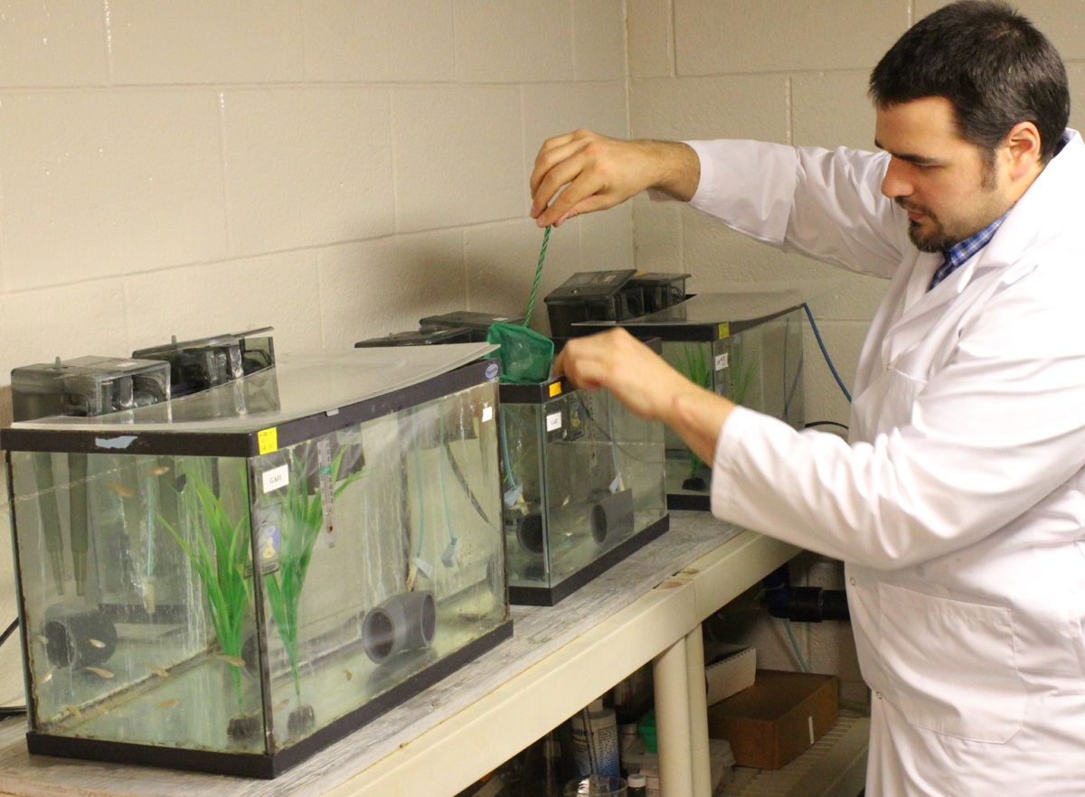
Diluted bitumen, also known as dilbit, a mixture of oil sands bitumen and natural gas dilutants can seriously harm fish populations, according to research study at Queen’s University and the Royal Military College of Canada published this week.
At toxic concentrations, effects of dilbit on exposed fish included deformities and clear signs of genetic and physiological stress at hatch, plus abnormal or uninflated swim bladders, an internal gas-filled organ that allows fish to control their buoyancy. Exposure to dilbit reduces their rate of survival by impairing their ability to feed and to avoid predators.
Post-doctoral fellow Barry Madison works with the fish in Valerie Langlois’ lab. (Queen’s University)
Among the other findings from the study were
Embryo toxicity of dilbit was comparable to that of conventional oils.
Developmental malformations increased with increasing dilbit concentrations.
Chemical dispersion broadened the genotoxic effects of dilbit
“This new study provides a clearer perspective on the potential risks to Canada’s aquatic resources of dilbit spills, and a technical basis for decisions on dilbit transportation within Canada,” says Peter Hodson Environment Studies, Biology at Queens. “It reduces some of the uncertainty and unknowns about the hazards of dilbit.”
This study characterized the toxicity and physiological effects of unweathered diluted bitumen (Access Western Blend dilbit; AWB) to a fish used for laboratory studies. Embryos of Japanese medaka (Oryzias latipes) were exposed for 17 days to dilutions of dilbit physically-dispersed by water and chemically-dispersed by dispersants
AWB dilbit exposure was not lethal to medaka, but resulted in a high prevalence of blue sac disease (BSD), impaired development, and abnormal or un-inflated swim bladders. Blue sac is a disease of young trout and other salmonid species; usually caused by unsuitable hatchery water. It turns the yolk sac bluish and is thought to be caused by a lack of oxygen.
The research was funded by Fisheries and Oceans Canada’s National Contaminants Advisory Group and the next stage will determine whether fish species native to Canada will be affected by dilbit exposure. The work also includes the development of genetic markers of exposure to dilbit and toxicity that could be used to assess whether wild fish that survive a spill are still affected.
The research team includes Dr. Valérie Langlois (Environmental Studies, Royal Military College of Canada) and Dr. Barry Madison (Royal Military College of Canada).
Dr. Hodson is also a member of a Queen’s research team tasked to determine whether dilbit spilled into rivers would contaminate bed sediments, specifically areas where fish such as salmon, trout, chars, whitefish and graylings spawn, to the extent that the survival of their embryos would be affected.
The research was published in ScienceDirect and is one of the first studies of dilbit on young fish.
The finding could be significant because both the proposed Northern Gateway pipeline and the proposed Kinder Morgan expansion will cross areas near spawning streams.