Geological Survey of Canada identifies tsunami hazard, possible fault line on Douglas Channel

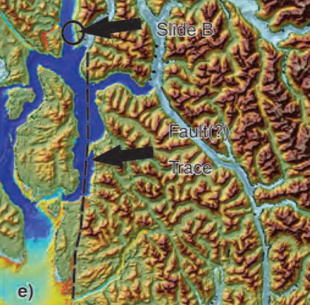
Fault zone map Douglas Chanel
A map from the Geological Survey of Canada showing the line of a possible seismic fault on Douglas Channel (Geological Survey of Canada)


Updates with statement from Natural Resources Canada, new filings by Enbridge Northern Gateway and the Attorney General of Canada (in box below)

The Geological Survey of Canada has identified a tsunami hazard and a possible seismic fault in Douglas Channel near Kitimat. A scientific paper by the Geological Survey and the Department of Fisheries and Oceans says there were once two giant landslides on Douglas Channel that triggered major tsunamis and that the landslides were possibly caused by an earthquake on the fault line.

Kitimat is the proposed site of the Enbridge Northern Gateway project and at least three liquified natural gas projects.

If the projects go ahead, hundreds of supertankers with either bitumen or LNG will be sailing in the channel for years to come.

A filing by the Attorney General of Canada with the Northern Gateway Joint Review Panel is asking the JRP for leave to file late written evidence long after the original deadline of December 2011. The Attorney General’s motion was filed on August 17, but went unnoticed until the Kitimat environmental group Douglas Channel Watch brought the matter up with District of Kitimat Council tonight (Sept. 17).

Appended to the Attorney General’s motion is a copy of a scientific paper from the Geological Survey “Submarine slope failures and tsunami hazards in coast British Columbia: Douglas Channel and Kitimat Arm” by Kim W Conway, J.V. Barrie of the Geological Survey and Richard E. Thomson of the Department of Fisheries and Oceans.

The report says the scientists discovered “evidence of large submarine slope failures in southern Douglas Channel.”

It goes on to say: “The failures comprise blocks of bedrock and related materials that appear to have been detached directly from the near shore off Hawkesbury Island.” Hawkesbury Island and many of the other islands in Douglas Channel are built up with material left over from the ice age glaciers and thus are vulnerable to displacement and landslides.

The research identified two slides, one estimated at 32 million cubic metres and a second of 31 million cubic metres. The report goes on to say that the discovery of an “apparently active fault presents the possibility that they may have been triggered by ground motion or surface rupture of the fault during past earthquake events.”

The slope failure landslides are covered with thick layers of mud, and that, the scientists say, could mean that the failures could be ancient, possibly occurring 5.000 to 10,000 years ago. Further research is needed to confirm the date of the giant slides.

What is worrying about the discovery is that fact that there were two recent submarine slope failures on the Kitimat Arm of Douglas Channel. both creating tsunamis. The first slope failure occurred on October 17, 1974, triggering a 2.4 metre tsunami at low tide. Then on April 27, 1975 there was a second slope failure near low tide on the northeast slope of the Kitimat Arm that generated an 8.2 metre tsunami. The 1975 tsunami destroyed the Northland Navigation dock near Kitimat and damaged the Haisla First Nation docks at Kitamaat Village.

The paper says that “Additional geological research is required to better delineate the age of the submarine failures, their triggers, and their mechanisms of emplacement.”

Urgent new research is underway and the filing by the Attorney General says when the Department of Justice requested leave to file late evidence says it anticipates that the further research by DFO is expected to be completed by November 1. The Natural Resources Canada Earth Sciences Sector began a national assessment of submarine slope failures in Canada in late 2011 and completion of the Pacific portion of this assessment is targeted for December of 2012.

The Attorney General’s filing says that DFO is now modelling “potential wave heights and speeds that may have resulted from the two previously unrecognized submarine slope failures in the Douglas Channel.” The model will use high resolution scans of the Douglas Channel seafloor to create the models.

The survey of Douglas Channel in 2010 suggests the possible existence of a fault immediately to the south of the second ancient slide on Hawkesbury Island.

The GSC paper says that evidence for a continuous fault was observed by aligned stream beds and fractures on the south end of Hawkesbury Island, about four kilometers from the site of the second ancient slide. The possible fault then appears to terminate far to the south near Aristazabal Island on the Inside Passage. The Geological Survey says that eleven small earthquakes, all less than magnitude three, have appeared with 20 kilometres of the suspected fault over the past 25 years.

The paper says that the scientists conclude that the slides appear to have left very steep slopes at or near the shoreline that could be susceptible to future failure events.

A large potential slope failure has been identified near one of the ancient slides….

in the absence of additional evidence, the fault must be considered a potential trigger for the submarine failure events….the triggers for the failures have not been defined; however, their proximity to a potentially active fault represents one potential source. The failures probably generated tsunamis during emplacement and conditions exist for similar failures and associated tsunamis to occur along this segment of Douglas Channel in the future.

The scientists say that detailed tsunami modelling is underway to

provide an improved understanding of the generation, propagation, attenuation, and likely coastal inundation of tsunami waves that would have been created by slides… or that could be generated from similar future events. Only through the development and application of this type of tsunami modelling will it be possible to gauge the level of hazard posed by the identified submarine slope failures to shore installations and infrastructure, or to devise ways to effectively mitigate the impacts of future such events.

The filing by the Attorney General offers to bring the scientists to the Joint Review Panel to appear as witnesses sometime during the final hearings.

The filing notes that the current evidence tendered to the JRP by Enbridge, and other parties does demonstrate the potential for marine geohazards and associated tsunami events. Enbridge’s design of the proposed Northern Gateway marine terminal and its operational plans took into consideration the current state of knowledge of geohazards including earthquakes and tsunamis at the time of filing. Enbridge has said it would undertake further geological survey during the detailed design phase for the terminal.

At the time Natural Resources Canada noted that the information provided for the Environmental Review was sufficient at that time, now the Attorney General says:

the geographic scope for potential landslide induced tsunami hazards is now better understood to extend beyond the Kitimat Arm. NRCan and DFO seek by this motion to ensure that this Panel, and the Parties before the Panel, have the most up to date information on geohazards in the Douglas Channel.


Updates: DFO report in October will clarify the tsunamis in Douglas Channel.


Statement from Natural Resources Canada

Natural Resources Canada sent this statement to Northwest Coast Energy News on September 20, 2012.

In reference to the opening paragraph of your September 18th editorial entitled Geological Survey of Canada identifies tsunami hazard: Possible fault line on Douglas Channel, we would like to clarify the following. Although the ancient large submarine slope failures which our scientists have identified may have caused tsunamis, this is not a certainty. It is important to note that Fisheries and Oceans Canada is currently studying this information to model potential wave heights and speeds.

As our report states, only through the development and application of this type of tsunami modelling will it be possible to gauge the level of hazard posed by the identified submarine slope failures to shore installations and infrastructure, or to devise ways to effectively mitigate the impacts of future such events.

 Northern Gateway response filed on August 31, 2012

Enbridge Northern Gateway filed this response to the Attorney General’s motion on August 31.

This motion of the Federal Government Participants requests permission to file late evidence consisting of a report entitled “Submarine Slope Failures and
Tsunami Hazard in Coastal British Columbia: Douglas Channel and Kitimat Arm” regarding tsunami hazard and additional modelling work based on that report.

Northern Gateway does not object to the filing of this late intervenor evidence.
It may be relevant and Northern Gateway accepts that theevidence could not be filed earlier. However, Northern Gateway would like the opportunity to conductits own additional modelling work which it would be prepared to provide to DFO for comment prior to the filing of any modelling work by DFO in this proceeding.

Attorney General response to Enbridge on September 10, 2012.

The Attorney General of Canada responded to Enbridge by saying:

Attorney General responds DFo is prepared to await filing its subseqent modelling work in these proceedings until such time as it has received, reviewed and commented upon additional modelling work as proposed by NGP Inc.

DFO nots howeverand wishes to alert the JRP that the NGP INc proposed may occasion a delay in the filing of the DFO moedling work which is now proposed for filing on or about October 31, 2012. Delivery of DFO comments as requested will depend on when DFO received the NGP Inc modelling work, the time and resources required by DFO to study and provide comments on the NGP modelling work and unforeseen factors which may have an impact upon completion the commentary. As such,

DFO is prepared to file its modeling work on or about October 31, 2012, but subject to any further direction or request by the panel.


Map of Douglas Channel
Geological Survey of Canada map of Douglas Channel showing the area surveyed which discovered the landslides and possible fault line. (Geological Survey of Canada)

;

;

Map of slides at Kitimat
Map from the Geological Survey of Canada showing the landslides on the Kitimat Arm which triggered tsunamis in 1974 and 1975 (Geological Survey of Canada)

;

;

Slide at Hawkesbury Island
Map from the Geological Survey of Canada showing the giant slide on the southern tip of Hawkesbury Island. (Geological Survey of Canada)

;

Hawkesbury Island slide map
Map from the Geological Survey of Canada showing the second giant slide on the coast of Hawkesbury Island on Douglas Channel (Geological Survey of Canada)

Department_of_Justice Notice of Motion of the Attorney General of Canada Seeking to Tender Supplementary Written Evidence (pdf)

Submarine Slope Failures and Tsunami Hazard in Coastal British Columbia Douglas Channel and Kitimat Arm PDF

What is it about Douglas Channel islands? Now a US agency has added a “Douglas Island”

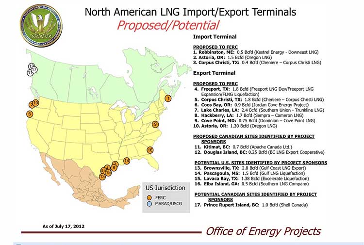
US FERC Map of LNG terminals in North America
Map from the United States Federal Energy Regulatory Commission showing LNG export terminal projects in North America (FERC)

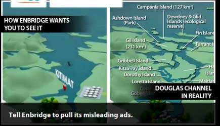
What is it about the islands in Douglas Channel? First, Enbridge gets in to a lot of hot water, so to speak, for erasing the islands in Douglas Channel in an animation promoting the Northern Gateway Pipeline.  See for example The Vancouver Sun on back on Aug. 16, 2012, when it picked up a story from the Times Colonist – Enbridge map sinks islands, angers critics.   The controversial video segment showed Douglas Channel wide open for navigation, rather than marked with about one thousand square kilometres of mountainous islands. Map of Douglas Channel Islands from Leadnow.ca This map, created by the Leadnow.ca and  Sumofus.org websites was widely used by the media to show the difference.  Enbridge later amended its video with a disclaimer that it is “broadly representational.” A video by Shortt and Epic Productions “This is Not An Enbridge animation” showing the beauty of northwestern BC quickly went viral.

As this was happening, the United States government Federal Energy Regulatory Commission issued a map that shows Liquified Natural Gas import and export terminals across North America, a map that adds an island to the Channel–“Douglas Island.”

In fact, the map manages to get a lot about Canadian LNG projects wrong. It locates the BC LNG project on the non-existent Douglas Island. The company’s name Douglas Channel Energy Partnership actually gives the proper location this way

 south of the Moon Bay Marina, within the District of Kitimat and the asserted traditional territory of the Haisla Nation. The site is approximately 10 km southwest of Kitimat and 7 km north of Bees Cove Indian Reserve 6 (Bish Cove)

The small cove where BCLNG will put its barges to create the LNG is often locally called North Cove.

The FERC map also misplaces the Shell LNG project, now known as LNGCanada, in Prince Rupert, even though Shell confirmed the Kitimat location on May 15, 2012. It also calls it Prince Rupert Island, although the town of Prince Rupert is actually located on Kaien Island.

The map does apparently get the KM LNG project somewhat correct, attributing it to Apache Canada, but leaving off Apache’s partners, Encana and EOG.

The map recently also appeared on the website of Oregon Public Broadcasting in an article Five Keys To The Pacific Northwest’s Natural Gas Export Debate by reporter Amelia Templeton, which outlines the growing controversy over the plans to export US LNG through Coos Bay, Oregon via the Jordan Cove Project.

It appears that in Oregon, the Coos Bay LNG project is becoming as controversial as the Northern Gateway project is in Canada.

The issues outlined by Templeton include the threat of expropriation (called “eminent domain” in the US and also a key issue in the debate over the Keystone XL pipeline on the plains).  There are arguments on jobs versus the environment, especially the perceived threat to wild rivers and salmon spawning grounds. Finally one issue that is lower on the agenda in northwestern BC but a big worry in Oregon, the potential for a devastating earthquake along the Cascadia fault.

During the NEB hearings on the KM LNG (Apache/EOG/Encana) project in June, 2011, many of the  “expert” witnesses urged that that first Kitimat project go ahead quickly because of perceived competition from Oregon.

Unlike in Oregon, LNG projects are generally perceived positively in the northwest and all three are going ahead, although not as quickly as originally planned due to market volatility among prime potential customers in Asia.


Water, not oil, is the hot issue this summer in Kitimat

Kitimat's "Hospital Beach" on March 17, 2012, with the construction at the Rio Tinto Alcan plant in the background, before the area was closed to the public. (Robin Rowland) (Robin Rowland)
Kitimat’s “Hospital Beach” on March 17, 2012, with the construction at the Rio Tinto Alcan plant in the background, before the area was closed to the public. (Robin Rowland)


The hottest issue in Kitimat this summer is water, not oil. For us, this summer can be summed up by saying: “Water, water everywhere, but you can’t get there from here.”

Even with David Black’s proposal for an oil refinery on a hill 25 kilometres north of Kitimat, residents here know that the Enbridge Northern Gateway debate has gone on for years and will go on for many years to come.

As environmentalists worldwide celebrate the beauty of Douglas Channel, and decry the dangers that tanker traffic could pose to the channel, many people in Kitimat are cut off from the waterfront.

At the District of Kitimat Council meeting on August 7, Coun. Mario Feldhoff introduced a motion calling for a study in an effort to find ways to launch kayaks into the ocean. Yes that’s right, according to members of council, you can’t even drop a kayak into the waters of Douglas Channel unless you pay the kind marina a launch fee usually charged for larger fishing boats. Kitimat is down to only one expensive boat launch.

In 2010, there were three marinas in Kitimat: one privately operated at a place called Moon Bay, a large marina owned by the Kitimat Stikine Regional District at MK Bay and a small marina at Minette Bay, also the site of a log export operation. There was also a boat launch on land known as “Alcan beach” or “Hospital Beach” on property owned by Rio Tinto Alcan (RTA) near the aluminum smelter. Hospital Beach is the only beach in Kitimat (named because it is on the site of the town’s original hospital in the 1950s). Moon Bay was located on land owned by RTA, and in April 2010, it ordered the marina shut down.

According to RTA spokesperson Colleen Nyce, that was largely due to concerns about how the marina was being operated.

Some people who moored their boats at Moon Bay moved to MK Bay (if there was room). Others hauled their boats out of the water and parked them in their driveways. In the ensuing two years, there have been increasing stories about mismanagement at MK Bay and complaints about moorageand launching fees that are much higher than elsewhere in the province.

This spring, citing construction at the smelter, RTA closed public access to Hospital Beach for picnics, kids’ play and just looking at the water. That meant the boat launch was also off-limits. RTA spokesperson Nyce said:

The Rio Tinto Alcan site is now a full fledged construction zone with constant vehicular and heavy duty construction traffic. To that end, and as Rio Tinto Alcan representatives have always said, during construction we will take necessary steps to eliminate potential hazards to the general public on our road including access to Hospital Beach. Therefore, Hospital Beach will be closed to the public until construction is complete or until we believe it is more safe for public access.

Before access was closed, if a Kitimat resident was driving to Hospital Beach, they pass what was once a rough logging road that snaked its way along the shores of Douglas Channel toward Bish Cove. Now Bish Cove is the site of the Kitimat LNG project terminal. As part of the construction process, KM LNG upgraded the road. However, as the pace of construction increases KM LNG is now limiting access to the road and its views of the channel.

Why is there no access to the waterfront, or for that matter to the magnificent Kitimat River estuary?

It goes back to 1950 when the province of B.C., in a loosely worded agreement with what was then Alcan and in an equally non-specific Industrial Development Act, handed over the land where Kitimat is now to the company.

That included almost all the waterfront and the estuary. On the estuary, there is one small area of land that is a reserve for the Haisla Nation and one small area not in RTA domain owned by the District of Kitimat — but there is no right of way through a potential private development. Over the years, and especially since Rio Tinto took over Alcan, there have been more and more restrictions placed on access to Kitimat’s waterfront.

Restricted access has become such an important issue that it came up during the National Energy Board hearings on the Kitimat LNG project and was part of the NEB ruling granting KM LNG its export licence. Access to Kitimat’s waterfront is also a factor in the Enbridge Northern Gateway project, although that part is lost in all the bigger issues.

The fact that you can’t get to the waterfront and the estuary are a problem not only for community recreation; the inability for a resident or visitor to launch a kayak or small boat into the channel, much less larger fishing or recreational vessels, has put the brake on expansion of Kitimat’s already lucrative fishing, guiding and boating services.

There is already a lot of skepticism in Kitimat — due to the boom and bust of the industrial cycle — about all those promises of jobs and prosperity from industrial development. Restricted access to the ocean means that despite the growing number of jobs in Kitimat, corporate policy makes it hard to enjoy the benefits of living on the Douglas Channel.

It is the kind of externality that is always ignored by economists and is totally irrelevant to those business writers who claim to be experts in Kitimat but who have never been within 1,000 kilometres of the town.

You look out your window at the mountains and ocean of Douglas Channel and ask why can’t the residents and tourists go to the beach? That could be a key issue in the Enbridge Northern Gateway debate.

Harper government reserves Gateway environmental decision for the cabinet, sets Dec. 31, 2013 deadline for JRP

The future of the Northern Gateway project is now completely in the hands of Prime Minister Stephen Harper’s cabinet.

Today, Friday, August 3, 2012, Environment Minister Peter Kent used the provisions of what the Harper government calls the Jobs, Growth and Long Term Prosperity Act (former Bill C-38) to set a final deadline for a report from the Northern Gateway Joint Review Panel  on December 31, 2013 and reserve the final environmental decision for the Governor-in-Council.

Today’s move, in effect, is the final gutting of the Joint Review Process, making it irrelevant, since, as long suspected, the government will now make the decision on its own.

The Joint Review Panel no longer has the power to reject the Northern Gateway on environmental grounds, that is now solely up to the Harper cabinet. Once the Gateway project is approved, as expected, the NEB has been ordered to issue the approval certificate within seven days.

By releasing the news on a Friday afternoon before a holiday weekend, the Harper government spin doctors through Environment Minister Peter Kent have also pulled the classic government move of releasing bad news when it will least be noticed.

There is also the new agreement between the Ministry of Environment and the National Energy Board. The revised memorandum of agreement says:

The Governor in Council will make the decision on the environmental assessment (whether the project is likely to cause significant adverse environmental effects and if, so whether such effects are justified in the circumstances). The Governor in Council will decide, by order, whether the board should issue a certificate and will give reasons for the order.

Under the act, the NEB now has to file its environmental assessments within 543 days of the act coming into force, hence the imposed deadline.

If there are no excluded periods this would mean that the environmental assessment and report must be submitted no later than Dec. 31, 2013.

The final paragraph of Kent’s letter also says

If the Project is approved by the Governor in Council, the NEB will issue the certificate of public convenience and necessity within seven days of the Governor in Council’s order.

That’s a clear indication that the Harper government still intends at this point to fast track the Northern Gateway project.

Apart from giving the most environment unfriendly cabinet in Canadian history the decision power, most of the memorandum of agreement are legalistic changes necessary to bring the former agreement into compliance with the new law.

The environmental sections of the agreement, based on the amendments to the Environmental Assessment act have a couple of interesting points

any change that the project may cause in the environment, including any change it may cause in listed wildlife species as critical habitat or residences of that species….

Although the memo goes on to say

any change to the project that may be caused by the environment whether such change or effect occurs within or outside Canada

While this may be simply legalistic language, given the overall tone of the Harper government’s policy, especially the changes in the Fisheries Act that only protects fish habitat when it affects  commercial species, one has to wonder if the emphasis on listed (that is threatened or endangered) species is again a narrowing of the criterion for approving the pipeline.

The second phrase is also ambiguous, seemingly to imply that the environment could be to blame  for any problems the project may face. Opponents have long pointed out that the environmental conditions and risks such as geologic instability along the pipeline route and the heavy weather in the waters off British Columbia are factors that increase the danger of an oil spill event whether on land or sea. However, the new agreement  presents an almost Orwellian scenario that would blame the environment, an “Act of God” in insurance terms, rather than the company or the government for any future disaster.

The main phrase in the agreement “whether such effects are justified in the circumstances” clearly indicates that the Harper government is fully prepared to ignore the environmental fallout of the Northern Gateway project and so the stage is set for a much wider political battle.

Peter Kent letter to JRP concerning the Northern Gateway Pipeline Project  (pdf)

Amendment to the Agreement concerning the Joint Review of the Northern Gateway Pipeline Project  (pdf)


Gateway JRP denies request from Nathan Cullen to hold hearings in Kitimat

The Northern Gateway Joint Review Panel today denied a request from Skeena Bulkley Valley MP to reconsider its decision not to hold the questioning round of final hearings in Kitimat. The JRP is still reserving its decision on locations for final arguments.

The panel had previously decided to hold those hearings in Prince Rupert, Prince George and Edmonton.

In its ruling on Cullen’s request, the JRP said:

Your request for the Panel to reconsider its decision on the locations for the questioning phase of the final hearings did not contain any new information that was not considered by the Panel in its original determination. As such, your request is denied. The Panel further notes that no decision has been made with respect to the location for the final hearings for final argument. As indicated in Procedural Direction #8, these locations will be announced at a later date.


Cullen had also asked to be allowed to question government participants in the hearing.  That request was also denied because filed the request after the deadline. Cullen also plans to question Northern Gateway witnesses and so the JRP reminded him that:

In accordance with the Panel’s letter of 25 July 2012, you are reminded that the names of the witnesses or witness panels you intend to question and an estimate of how much time you will need to question each party or witness panel is to be submitted by 3 August 2012.

NEB conducting safety audit of Enbridge

The National Energy Board is following up a highly critical report by the US National Transportation Safety Board on the Marshall, Michigan spill by conducting an overall safety audit of Enbridge pipeline management and practices.  The NEB says the review began even before the NTSB report was released:

even prior to the release of the final report, we have been reviewing Enbridge’s management practices. In the next weeks and months, we will be conducting safety audits to review and confirm that improvements, particularly to their control room practices in Edmonton, are satisfactory.

In a letter to the public from NEB chair, Gaétan Caron, posted on the NEB website, the agency says: “Pipeline safety is and always has been of paramount concern to the National Energy Board and we recognize it is of growing concern to Canadians.”

The letter goes on to say:

Given recent events, it is important that Canadians understand how we hold companies accountable for public safety and protection of the environment and take swift and appropriate action when they do not.

The Board takes a proactive approach to preventing spills and releases, with the ultimate goal of seeing none at all. We require pipeline companies to anticipate, prevent, manage and mitigate potentially dangerous conditions associated with their pipelines.

To do this, we conduct compliance verification activities which include things such as inspections, compliance meetings, emergency exercises, audits and investigations on a regular basis with all companies we regulate. In the specific case of Enbridge, in recent years the NEB has conducted approximately 25 compliance verification activities per year, focusing on every aspect of their management system. In addition, the NEB imposed two precautionary pressure restrictions on Enbridge pipelines, one in 2010 and another in 2011, which remain in effect.

When the NEB identifies deficiencies in a company’s systems, projects or programs, we require the company to immediately implement changes to correct those deficiencies or to develop a corrective action plan for NEB approval. It is important to note that we aim to prevent incidents from occurring in the first place and we will take all available actions at our disposal to protect the environment and the public. The NEB may revoke authorizations, impose safety orders that restrict operations, issue stop-work orders and monetary penalties as well as pursue criminal prosecution.

The NEB has also reviewed the synopsis of the National Transportation Safety Board’s report on Enbridge’s Line 6B rupture in Michigan in 2010 to see what we can learn in the interests of public safety and environmental protection. A thorough review of the final report will be conducted in order to identify all lessons that may be applied to pipelines and companies under the Board’s jurisdiction, however even prior to the release of the final report, we have been reviewing Enbridge’s management practices. In the next weeks and months, we will be conducting safety audits to review and confirm that improvements, particularly to their control room practices in Edmonton, are satisfactory.

The NEB goes on to stay that Jobs, Growth and Long-term Prosperity Act (formerly Bill C-38) is giving the agency more bight:

 the Government of Canada will be adding another tool to our compliance and enforcement toolkit: administrative monetary penalties (AMPs). The new AMP sections in the NEB Act set out the maximum daily penalties for both individuals and companies. For individuals the maximum daily penalty is $25,000 for each violation and for companies the maximum daily penalty is $100,000 per violation.

The Act stipulates that each day a violation continues is considered to be a separate violation. This means that separate penalties could be issued per infraction, per day with no maximum total financial penalty.

Some of the details of the AMPs design are described in the government amendments to the NEB Act, but other details, such as what activities will be considered violations, will be written in a new regulation. We have committed to have these new regulations ready to use by July 6, 2013.

The NEB says it will continue to make public any enforcement measures it takes.

As a part of our Action Plan on Safety and Environmental Protection, we began posting all documents related to Board-initiated safety and environmental compliance actions to our website in fall of 2011.

The Board is committed to continually improving the way we do business and we welcome any opportunity that allows us to do so in the interests of pipeline safety and environmental protection.

Enbridge has not yet responded to the NEB release.

Haisla ask Gateway JRP to force Enbridge to release more Kalamazoo spill information

The Haisla Nation have asked the Northern Gateway Joint Review panel to force Enbridge to reveal more information about the pipeline rupture and oil spill near Kalamazoo, Michigan, in July 2010. The Haisla are also asking for more and better information about the $500 million project upgrades that Enbridge announced last month.

In a notice of motion filed July 30, with the JRP, lawyers representing the Haisla Nation note that they had previously asked Enbridge “a number of questions relating to Enbridge’s spill of 3,785,000 litres of diluted bitumen into the Kalamazoo River at Marshall, Michigan (the ‘Kalamazoo Spill’).”

The notice then notes that “Northern Gateway refused to reply as the matter was under investigation by the United States National Transportation Safety Board… The NTSB’s Accident Report was adopted on July 10, 2012 and has now been released to the public. The basis for Northern Gateway’s refusal to answer the Haisla Nation’s information requests is, therefore, no longer present.”

The Haisla are asking the JRP

that Northern Gateway is required to file evidence relating to the Kalamazoo Spill
which identifies the cause of the pipeline rupture and the extent to which
Enbridge’s pipeline maintenance, monitoring and response approach caused and
contributed to the volume of the spill by a date to be fixed by the Panel;

As for the upgrades, the Haisla notice of motion notes

Northern Gateway has identified additional design features, which it states will “enhance the safety and reliability of the pipelines over and above standard industry practice”. The design features identified in the Reply Evidence include increased wall thickness of the pipeline, additional increases in pipe thickness for crossings at major tributaries to the Fraser, Skeena and Kitimat River, the placement of remotely operated isolation valves on each side of major tributaries of the Fraser,Skeena and Kitimat Rivers, and dual remote monitoring systems ….
Northern Gateway has not provided any details relating to these proposed design
features. Their relevance and suitability to enhancing safety and reliability of the
pipelines cannot, therefore, be assessed.

The motion asks

that Northern Gateway is required to provide details of its proposed additional
design features for thicker pipes for the pipeline generally and at identified
watercourse crossings, for additional valve placements, and for additional remote
monitoring, as well as all studies and reports that support how these additional
design features enhance pipeline safety, by a date to be fixed by the Panel.

The Haisla motion also asks for more details on various environmental and other questions.

The Joint Review Panel has not yet ruled on the Haisla motion.

Haisla Nation Notice of Motion  (pdf)

Kitimat asks Joint Review Panel to clarify, reconsider decision to bypass town for final hearings

The District of Kitimat has asked the Northern Gateway Joint Review Panel to reconsider its decision to bypass the town for the final questioning and final argument hearings “given the significant impact the project will have on Kitimat.”

On July 16, 2012, Mayor Joanne Monaghan sent a letter to the JRP asking for the reconsideration. That letter was posted recently on the JRP website.

Monaghan’s letter says:

The District of Kitimat occupies a key location in the Northern Gateway project. Enbridge’s pipeline will terminate in Kitimat and the new terminal for shipping bitumen will be located here. Our community will not only be subjected to the risks posed by two pipelines, but also is the only community along the pipeline route that will be assuming the risks associated with tanker traffic on Douglas Channel.

We understand that the Joint Review Panel chooses appropriate hearing facilities that are safe, of adequate size and can logistically and technologically accommodate a hearing with many participants. Kitimat can comfortably provide all of those components, therefore we request clarification on the decision to exclude Kitimat from the hearings.

On July 5, the JRP decided to hold the the questioning hearings will begin on September 4, 2012 in Edmonton followed by hearings in Prince George and Prince Rupert.

The Joint Review Panel was able to hold a successful preliminary hearing at a packed Riverlodge Recreation Centre, in Kitimat, in August, 2010 and the National Energy Board held hearings on the KM LNG project at Riverlodge in June, 2011. The current JRP hearings were held at the Haisla Recreation Centre at Kitamaat Village at the request of the Haisla Nation to accommodate the needs of the Elders.


District of Kitimat Letter to JRP  (pdf)

Province of BC refuses to provide witnesses for Gateway Joint Review hearings

The province of British Columbia has refused requests from some of the intervenors in the Northern Gateway Joint Review to provide witnesses for cross-examination during the final stages of the hearings.

In a letter to the JRP dated on July 20, and posted recently on the JRP website, Christopher Jones, counsel for the province in the hearings says: “I write only to note that the province is an intervnor, not a government participant. Also as the province has not filed evidence, it will not be providing witnesses for cross-examination at the final hearings.”

It was just four days later that Premier Christy Clark and members of her cabinet, in releasing the  Liberal government’s five conditions for the Northern Gateway project which called for “Successful completion of the environmental review process.”   The provincial government has consistently refused to take part in the proceedings, and with the credibility of the Joint Review process already under question because of the limitations on reviews in Stephen Harper’s Bill C-38, BC’s continued refusal to participate can only further undermine that credibility.

 
Province of British Columbia Questioning at Final Hearings (pdf)