The Department of Fisheries and Oceans has handed responsibility for fish and fish habitat along pipeline routes over to the National Energy Board. The same agreement also gives the National Energy Board responsibility for dealing with First Nations fisheries if a pipeline or power line crosses their traditional territory.
DFO and NEB quietly announced a memorandum of agreement on December 16, 2013, that went largely unnoticed with the release three days later of the Joint Review Panel decision on Northern Gateway and the slow down in news coverage over the Christmas holidays.
As of December 16, 2013, Enbridge no longer has to apply to DFO for permits to alter fish habitat along the Northern Gateway route. It was also on December 16 that Kinder Morgan filed its application with the NEB for the expansion of its pipeline from Alberta to Burnaby.
Fish and fish habitat along those pipeline is now the responsibility of the Alberta-based, energy friendly National Energy Board.
Applications submitted to the NEB shall be reviewed under the Fisheries Protection Provisions of the Fisheries Act to determine if impacts shall occur, and if an authorization will be required under the Fisheries Act. The NEB shall also become responsible to determine if proposed projects will impact aquatic species at risk and require permitting under the Species at Risk Act. If the NEB determines than an authorization or permit will be required, DFO shall be notified and will be responsible for issuing the authorization or permit.
This MOU better integrates the Government of Canada’s initiative to streamline application processes by eliminating the requirement for duplicate reviews.
In the “Guiding Principles” of the memorandum of understanding between DFO and NEB, the first provision is
The Parties will use the provisions of this MOU to support the Government of Canada’s regulatory process improvement objectives through coordination to:
Facilitate effective and efficient use of government resources in order that regulatory decisions are made in a timely manner by applying a one-project one-review approach;
Promote clarity and consistency of the regulatory decision making process; and
Ensure responsibilities for mitigation, monitoring and reporting, compliance and enforcement, follow-up monitoring, and Aboriginal consultation are addressed.
Protecting fisheries and fish habitat is only the third priority in the MOU
Conservation and protection of fish and fish habitat, and listed aquatic species at risk and their critical habitat, will be managed in accordance with DFO’s regulatory and policy frameworks for the application of the fisheries protection provisions of the Fisheries Act and SARA [Species at Risk Act] respectively.
The question most people on the northwest coast and along BC’s rivers will ask (whether or not they support or oppose pipeline projects): Just how much expertise, if any, in fisheries and fish habitat can be found in the Calgary offices of the National Energy Board?
According to the FAQ posted on the NEB website, it is now up to the NEB to determine whether a project impacts fisheries or species at risk.
How will the MOU affect authorizations under the Fisheries Act?
The NEB will assess a project application and determine if mitigation strategies are needed to reduce or prevent impacts to fish or fish habitat. If the project could result in serious harm for fish then the NEB will inform DFO that a Fisheries Act authorization under paragraph 35(2)(b) is likely to be required. DFO will review and issue an authorization when appropriate, prior to project construction. Authorizations issued by DFO would relate to those watercourses impacted, not the entire project.
How will the MOU affect permits under SARA?
The NEB will assess a project application for potential impacts to aquatic species at risk. If an impact to a SARA-listed aquatic species may occur, the NEB will inform DFO. DFO will review and issue a permit under SARA when appropriate, prior to project construction.
The NEB claims that the MOU will not affect environmental protection
Will this MOU reduce environmental protection?
No, the NEB has always considered impacts to fish and fish habitat and aquatic species at risk when making its decisions. The initial assessment of impacts of federally regulated pipeline and power line projects
Another potentially troubling aspect of the agreement is that it makes the National Energy Board the lead agency in dealing with First Nations.
when the Crown contemplates conduct that may adversely affect established or potential Aboriginal and treaty rights in relation to the issuance of authorizations under the Fisheries Act, and/or permits under SARA, the NEB application assessment process will be relied upon by DFO to the extent possible, to ensure Aboriginal groups are consulted as required, and where appropriate accommodated;
Canada’s First Nations have dealt with DFO for generations and by and large both sides understand each other’s aims, even if they don’t always agree. The NEB, however, at least as seen during the JRP hearings, often showed little understanding or respect for First Nations. That means that already troubled relationship between First Nations and the Crown over pipelines is going to get a lot more troubled.
The memorandum of understanding between DFO and MOU is yet another result of the Harper government’s omnibus bills, which have the aim of efficiently approving energy projects while downplaying environmental costs.
It also means that from now on there must be a much more careful reading of the 209 conditions imposed by the Joint Review Panel on Enbridge to see if those conditions are actually going to be rigorously enforced or if all Enbridge has to do is to file reports with the NEB.
It also appears that the new and highly restrictive NEB procedures that restrict input from all but those the NEB considers “directly affected’ by a project will also apply to their new responsibility for fisheries.
(First in series of reports on how the Joint Review Panel report will affect the Kitimat region)
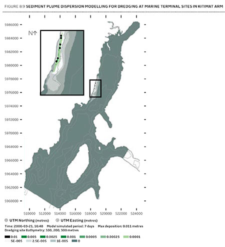
Joint Review map of Northern Gateway plans for dredging and blasting on Douglas Channel (JRP)
If there is a significant flaw in the Joint Review Panel report on Northern Gateway, it can be found in the panel’s analysis of Enbridge Northern Gateway’s plans to blast and dredge at the proposed Kitimat terminal site.
While the Joint Review Panel does consider what it calls “cumulative effects,” the panel plays down those effects and offers no specifics about interaction between the Northern Gateway project and the two liquified natural gas projects, the KM LNG project at Bish Cove and the BC LNG floating terminal at the old log dump.
It appears the JRP considered the legacy effects of the Rio Tinto Alcan smelter and other Kitimat industries while not taking into consideration future development.
The dredging and blasting planned by Northern Gateway, as Enbridge said in its evidence, appears to have only a minimal effect on Douglas Channel.
A glance at the map in the Joint Review ruling shows that that the dredging and blasting site is directly opposite Clio Bay, where Chevron, in partnership with the Haisla Nation, plan a remediation project using marine clay from the Bish Cove construction site to cap decades of sunken and rotting logs.
The Clio Bay project was not part of the evidence before the Joint Review Panel, the plans for the project were not formulated until well after the time for evidence before the JRP closed. But those deadlines show one area where the rules of evidence and procedure fail the people of northwestern BC.
The JRP is a snapshot in time and changes in the dynamics of the industrial development in the Kitimat Arm are not really considered beyond the terms of reference for the JRP.
It appears from the report that Enbridge plans to simply allow sediment from the blasting and dredging to float down Douglas Channel, dispersed by the currents and the outflow from the Kitimat River.
Northern Gateway said that dredging and blasting for marine terminal construction would result in a sediment plume that would extend over an area of 70,000 square metres for the duration of blasting activities.
Approximately 400 square metres of the assessed area of the marine terminal is expected to receive more than 1 centimetre of sediment deposition due to dredging. Outside of this area, typical sediment deposition levels alongshore where sediment is widely dispersed (a band approximately 4 kilometres long and 400 metres wide) are very low; in the range of 0.001 to 0.1 centimetres. Dredging and blasting activities are expected to occur over a period of approximately 18 weeks.
Northern Gateway expected most of the sediment plume created by construction activities to be minor in relation to natural background levels.
Northern Gateway would use bubble curtains to reduce pressure and acoustic effects of blasting, and silt curtains to reduce the effect of sedimentation from dredging. It said that bubble curtains are used extensively for other activities, such as pile driving, to reduce the effect of high pressure pulses that can cause injury to fish.
It added that bubble curtains have been tested extensively with blasts, and literature shows they are effective.
Northern Gateway said that physical effects from suspended sediment on marine fish and invertebrates could include abrasion and clogging of filtration mechanisms, which can interfere with ingestion and respiration. In extreme cases, effects could include smothering, burial, and mortality to fish and invertebrates. Direct chemical-related effects of suspended sediment on organisms, including reduced growth and survival, can also occur as a result of the uptake of contaminants
re-suspended by project construction activities, such as dredging and blasting, and as a result ofstorm events, tides, and currents.
The Haisla Nation and Raincoast Conservation objected to Northern Gateway’s figures, noting
Northern Gateway’s sediment and circulation model and its evidence related to contaminated sediment re-suspension at the terminal site. Both parties said that the sediment model was applied for the spring, when the increase in total suspended solids would be negligible compared to background values. In the event of delays, blasting and dredging would likely occur at other times of the year when effects would likely be higher, and these scenarios were not modelled.
The panel’s assessment of the area to be blasted found few species:
Species diversity within Kitimat Arm’s rocky intertidal community is generally low. Barnacles, mussels, periwinkles, and limpets can be found on rocky substrate. Sea urchins, moon snails, sea anemones, sea stars, and sea cucumbers are in shallow subtidal areas. Sandy areas are inhabited by commercially-harvested bivalves such as butter clams and cockles.
Northern Gateway told the JRP that it would “offset” any damage to Douglas Channel caused by the blasting and dredging
Northern Gateway said that construction, operations, and decommissioning of the marine terminal would result in both permanent and temporary alteration of marine fish habitat. Dredging and blasting, and installing physical structures in the water column for the marine terminal would permanently alter marine fish habitat. Based on the current terminal design, in-water site preparation would result in the physical alteration of approximately 1.6 hectares of subtidal marine habitat and 0.38 hectares of intertidal marine habitat. Northern Gateway expected approximately 353 square metres of subtidal marine habitat and 29 square metres of intertidal habitat to be permanently lost.This habitat would be compensated for by marine habitat offsets.
The project’s in-water vertical structures that would support the mooring and berthing structures could create new habitat, offsetting potential adverse effects. The structures may act as artificial reefs, providing marine fish habitat, food, and protection from predation. Although organisms currently inhabiting the work area would be killed, the exposed bedrock would be available for colonization as soon as the physical works are completed.
In its finding on marine sediment, the panel, as it does throughout the ruling, believes that the disruption to the environment caused by previous and ongoing human activity, means that the Northern Gateway Kitimat terminal won’t make that much difference.
Sediment quality in the marine environment is important because sediment provides habitat for benthic aquatic organisms. Northern Gateway’s baseline data for the area immediately surrounding the marine terminal indicated some contamination of water, sediments, and benthic organisms from previous industrial activity. Industrial activities in the Kitimat area have released contaminants through air emissions and effluent discharges since the 1960s. Sources of contaminants to Kitimat Arm
include effluent from a municipal wastewater treatment plant, the Alcan smelter, Methanex Corporation’s methanol plant, and the Eurocan pulpmill, as well as storm water runoff from these operations and the municipality.
Area is largely controlled by natural outflow from the Kitimat River with suspended sediment levels being highest during peak river runoff (May to July, and October) and lowest during winter. Storm events, tides, and currents can also suspend sediments. Levels of total suspended solids fluctuate seasonally and in response to climatic variations, but are generally highest during the summer.
Commercial and recreational vessels currently operating in the area may increase suspended solids by creating water turbulence that disturbs sediments. Given the current sediment contamination levels and the limited area over which sedimentation from construction activities would be expected to disperse, the Panel finds that the risk posed by disturbed contaminated sediment is low. Northern Gateway has committed to monitoring during construction to verify the predicted effects on sediment and water quality for both contaminants and total suspended solids..
The dredging and blasting section of the Joint Review Report is small when compared to the much more extensive sections on pipeline construction and tanker traffic, and the possible effects of a catastrophic oil spill.
Although minor, the marine sediment section exposes the question that was never asked, given the disruptions from years of log dumping at Clio Bay and Minette Bay and the decades of developments at the mouth of the Kitimat River, and future development from LNG, when do cumulative effects begin to overwhelm? How much is enough? How much is too much? If every project continues to be viewed in isolation, what will be left when every project is up and running?
Cover of Volume 1 of the Joint Review Panel ruling on Northern Gateway
If you read both the 76 pages of Volume One of the Northern Gateway Joint Review decision and the 417 pages of Volume 2, a total of 493 pages, one word keeps reappearing. That word is “burden.”
The JRP panel asks “How did we weigh the balance of burdens, benefits, and risks?”
And it says:
Many people and parties commented on the economic benefits and burdens that could be brought about by the Enbridge Northern Gateway Project. In our view, opening Pacific Basin markets wouldbe important to the Canadian economy and society. Though difficult to measure, we found that the economic benefits of the project would likely outweigh any economic burdens.
The JRP notes:
The Province of British Columbia and many hearing participants argued that most of the project’s economic benefits would flow to Alberta, the rest of Canada, and foreign shareholders in oil and pipeline companies. They said British Columbia would bear too many of the environmental and economic burdens and risks compared to the benefits.
But, as the panel does throughout the ruling, it accepts, with little, if any, skepticism, Northern Gateway’s evidence and assertion:
Northern Gateway said about three-quarters of construction employment would occur in British Columbia, and the province would get the largest share of direct benefits from continuing operations.
It does touch on the “burdens” faced by the Aboriginal people of northern BC and others in the event of a catastrophic spill.
In the unlikely event of a large oil spill, we found that there would be significant adverse effects on lands, waters, or resources used by Aboriginal groups. We found that these adverse effects would not be permanent and widespread. We recognize that reduced or interrupted access to lands, waters, or resources used by Aboriginal groups, including for country foods, may result in disruptions in the ability of Aboriginal groups to practice their traditional activities. We recognize that such an event would place burdens and challenges on affected Aboriginal groups. We find that such interruptions would be temporary. We also recognize that, during recovery from a spill, users of lands, waters, or resources may experience disruptions and possible changes in access or use.
And the JRP goes on to say:
We recommend approval of the Enbridge Northern Gateway Project, subject to the 209 conditions set out in Volume 2 of our report. We have concluded that the project would be in the public interest. We find that the project’s potential benefits for Canada and Canadians outweigh the potential burdens and risks….
We are of the view that opening Pacific Basin markets is important to the Canadian economy and society. Societal and economic benefits can be expected from the project. We find that the environmental burdens associated with project construction and routine operation can generally be effectively mitigated. Some environmental burdens may not be fully mitigated in spite of reasonable best efforts and techniques…. We acknowledge that this project may require some people and local communities to adapt to temporary disruptions during construction.
As for the chance of a major oil spill, again the JRP talks about burdens:
The environmental, societal, and economic burdens of a large oil spill, while unlikely and not permanent, would be significant. Through our conditions we require Northern Gateway to implement appropriate and effective spill prevention measures and spill response capabilities, so that the likelihood and consequences of a large spill would be minimized.
It is our view that, after mitigation, the likelihood of significant adverse environmental effects resulting from project malfunctions or accidents is very low.
And concludes:
We find that Canadians will be better off with this project than without it.
In the Joint Review ruling is one fact. Northern British Columbia must bear the “burden” of the Northern Gateway project for the good of Alberta and the rest of Canada. The JRP accepts, without much questioning, Northern Gateway’s assurances that environmental disruptions during construction will be minimal and that the chances of a major spill from either a pipeline or a tanker are minimal.
Canadians as a whole may be better off with the Northern Gateway. Whether the people who live along the pipeline and tanker route will be better off is another question, one which the Joint Review Panel dismisses with casual disdain.
Cover of Volume 2 of the Joint Review rulng on Northern Gateway
The politics of the Joint Review Panel
There are actually two Joint Review Panel reports.
One is political, one is regulatory. The political decision by the three member panel, two from Alberta and one from Ontario, is that the concerns of northwestern British Columbia are fully met by Enbridge Northern Gateway’s assurances. There is a second political decision, found throughout both volumes of the report, and the reader sees the Joint Review Panel has the notion that many parts of the environment have already been degraded by previous human activity, and that means the construction and operation of the Northern Gateway will have little consequence.
Here is where the Joint Review Panel is blind to its own bias. With its mandate to rule on the Canadian “public interest,” the panel makes the political determination that, in the Canadian public interest, northwestern BC must bear the “burden” of the project, while other political issues were not considered because, apparently those issues were outside the JRP’s mandate.
…some people asked us to consider the “downstream” emissions that could arise from upgrading, refining, and diluted bitumen use in China and elsewhere. These effects were outside our jurisdiction, and we did not consider them. We did consider emissions arising from construction activities, pipeline operations, and the engines of tankers in Canadian territorial waters.
During our hearings and in written submissions, many people urged us to include assessment of matters that were beyond the scope of the project and outside our mandate set out in the Joint Review Panel Agreement. These issues included both “upstream” oil development effects and “downstream” refining and use of the products shipped on the pipelines and tankers…Many people said the project would lead to increased greenhouse gas emissions and other environmental and social effects from oil sands development. We did not consider that there was a sufficiently direct connection between the project and any particular existing or proposed oil sands development or other oil production activities
If someone in Northwestern British Columbia favours the Northern Gateway project, if they believe (and many people do) what Enbridge Northern Gateway says about the economic benefits, then it is likely they will accept the burden and the further environmental degradation imposed by the Joint Review Panel on this region of British Columbia.
If, on other hand, for those who are opposed to the project, then the decision to impose the burden on this region is both unreasonable and undemocratic (since no one in northern BC, in the energy friendly east or the environmental west has been formally asked to accept or reject the project). For those opposed to the project, the idea that since the environment has already been disrupted by earlier industrial development, that Canadians can continue to degrade the environment with no consequence will only fuel opposition to the project.
As for the assertion that green house gas emissions were not part of the Joint Review Panel’s mandate, that is mendacious. The panel made a political decision on the role of the people of northwestern BC and the state of northwestern BC’s environment. The panel made a political decision to avoid ruling on the role of Northern Gateway in contributing to climate change or the larger world wide economic impact of pipelines and the bitumen sands.
Regulations
The Joint Review Panel is supposed to be a regulatory body and should be pipeline, terminal and tanker project go ahead after the expected court challenges from First Nations on rights, title and consultation and from the environmental groups, then those 209 conditions kick in.
While the Joint Review Panel largely accepts Enbridge Northern Gateway’s evidence with little questions, in some areas the panel does find flaws in what Northern Gateway planned. In a few instances, it actually accepts the recommendations from intervenors (many from First Nations, who while opposed to the project, successfully demanded route changes to through environmentally sensitive or culturally significant territory.)
When it comes to regulations, as opposed to politics, the Joint Review Panel has done its job and done it well. If all 209 conditions and the other suggestions found in the extensive second volume of the ruling are actually enforced then it is likely that the Northern Gateway will be the safe project that Enbridge says it will be and actually might meet BC Premier Christy Clark’s five conditions for heavy oil pipelines across BC and tankers off the BC coast.
But and there is a big but.
The question is, however, who is going to enforce the 209 conditions? In recent conversations on various social media, people who were quiet during the JRP hearings, have now come out in favour of the pipeline project. Read those comments and you will find that the vast majority of project supporters want those conditions strictly enforced. Long before the JRP findings and before Premier Christy Clark issued her five conditions, supporters of the Northern Gateway, speaking privately, often had their own list of a dozen or two dozen conditions for their support of the project.
The people of northwestern BC had already witnessed cuts to Fisheries and Oceans, Environment Canada and the Canadian Coast Guard in his region even before Stephen Harper got his majority government in May 2011.
Since the majority government Harper has cut millions of dollars from the budgets for environmental studies, monitoring and enforcement. The Joint Review Panel began its work under the stringent rules of the former Fisheries Act and the Navigable Waters Act, both of which were gutted in the Harper government’s omnibus bills. Government scientists have been muzzled and, if allowed to speak, can only speak through departmental spin doctors. The Joint Review Panel requires Enbridge Northern Gateway to file hundreds of reports on the progress of surveying, environmental studies, safety studies, construction plans and activities and project operations. What is going to happen to those reports? Will they be acted on, or just filed in a filing cabinet, perhaps posted on an obscure and hard to find location on the NEB website and then forgotten?
Will the National Energy Board have the staff and the expertise to enforce the 209 conditions? Will there be any staff left at Environment Canada, Transport Canada, Fisheries and Oceans and the Canadian Coast Guard where the conditions demand active participation by government agencies, or ongoing consultation between federal agencies and Northern Gateway? Will there actual be monitoring, participation and consultation between the project and the civil service, or will those activities amount to nothing more than meetings every six months or so, when reports are exchanged and then forgotten? Although Stephen Harper and his government say the Northern Gateway is a priority for the government, the bigger priority is a balanced budget and it is likely there will be more cuts in the coming federal budget, not enhancements to environmental protection for northwestern BC.
The opponents of the project might reluctantly agree to the 209 conditions if Harper government forces the project to go ahead. It will be up to the supporters to decide whether or not they will continue their support of Northern Gateway if the 209 conditions are nothing more than a few pages of Adobe PDF and nothing more.
In a news release, Rio Tinto says it is considering its future holdings in a Vancouver-based mining company named Northern Dynasty, which now is the main proponent of the copper and gold mine project. Rio Tinto “through QIT-Fer et Titane Inc., an indirect wholly-owned subsidiary of Rio Tinto plc, owns 18,145,845 common shares of Northern Dynasty, representing approximately 19.1 per cent of Northern Dynasty’s issued and outstanding shares.”
Rio Tinto says the review is part of the financially troubled conglomerate’s review of its mining holdings: “Rio Tinto will consider the Pebble Project’s fit with the Group’s strategy of investing in and operating long life and expandable assets, and with the strategy for its Copper business, which is focused on its four producing assets (Kennecott Utah Copper, Oyu Tolgoi and its interests in Escondida and Grasberg), and two development projects, La Granja in Peru and Resolution in Arizona.”
The Pebble Mine project is as controversial in Alaska and the western United States as the Northern Gateway pipeline project is in British Columbia. Critics say the proposed huge open pit copper and gold mine could endanger the Alaska headwaters of the Kvichak and Nushagak rivers, considered two of the world’s great salmon spawning grounds. Both flow into the “salmon nursery” in Bristol Bay, where young salmon go to feed, possibly also imperiling salmon stocks from both Alaska and British Columbia
New York City controller John Liu and California state controller John Chiang said their letter was prompted when Rio Tinto rival Anglo-American sold its share of the controversial project in September.
Their letter cited environmental concerns, including the fact that the project would leave 10 billion tonnes of mining waste near the salmon spawning grounds, increased regulatory scrutiny from the US Environmental Protection Agency and what the two controllers called “reputational risks” including opposition from Alaska First Nations and even jewelry companies like Tiffany & Co and Zales and Jostens. The letter cited a poll which showed 73 per cent of Americans, 84 per cent of Alaskans and 98 per cent of Bristol Bay residents opposed the project.
On December 19, the two controllers then called upon Rio Tinto to divest itself of the Northern Dynasty shares, calling, according to the Associated Press, Rio Tinto’s response “perfunctory.”
Rio Tinto spokesman David Outhwaite told AP the strategic review is not connected to that letter or a letter the financial officers sent Walsh.
Ango-American, one of Rio Tinto’s giant mining rivals, pulled out of the Pebble Mine project in September. Teck Cominco and Mitsubishi had pulled out earlier, leaving Rio Tinto as the only major company involved in the project.
When it decided to sell its share back to Northern Dynasty, Anglo-American also cited a “strategic review” of the company’s operations.
At the time, Rio Tinto’s Jennifer Ruso told the Alaska Dispatch, the company “will only participate in the project if it can be constructed, operated and closed in a manner that preserves the water, salmon, fisheries, wildlife and the environment. The project must also be developed in accordance with our strict standards for health, safety, environmental protection, cultural heritage, and community relations.”
Northern Dynasty and Rio Tinto then said they were considering an underground mine instead of an open pit operation, which did not satisfy environmental critics of the project.
On December 13, Northern Dynasty reported that it had re-acquired 100 per cent ownership of the Pebble Mine project after completing the pull out deal with Anglo-American.
The company, however, is looking for new partners. It says:
Our primary focus is to select the right partner for Northern Dynasty and the right investor for Alaska, a company with sufficient financial resources and technical capabilities, working experience in the United States and a shared commitment to environmentally sound and socially responsible development. We have little doubt that Pebble will attract major mining company interest in the months ahead.
The news release says that Northern Dynasty has spent US$556 million over the past few years and “substantial progress has been made toward our goal of permitting, constructing and operating a world-class, modern and environmentally responsible mine at Pebble that will co-exist with the fisheries resources of southwest Alaska.”
In the news release, Northern Dynasty President & CEO Ronald Thiessen said Pebble’s engineering design, environmental science and regulatory planning were advanced that the company would begin to ask for US and Alaska permitting under the National Environmental Policy Act (NEPA) sometime the first quarter of 2014.
It describes the project this way:
The Pebble Project is an initiative to responsibly develop a globally significant copper, gold and molybdenum deposit in southwest Alaska into a modern, long-life mine, which will benefit not only Northern Dynasty, but the people, culture and industries of the State of Alaska, as well as suppliers, consultants and industries in the Lower 48 United States of America.
A recent study authored by IHS Global Insight, entitled The Economic and Employment Contributions of a Conceptual Pebble Mine to the Alaska and United States Economies found the Pebble Project has the potential to support 15,000 American jobs and contribute more than $2.5 billion annually to US GDP over decades of production.
The Pebble Project is located 200 miles southwest of Anchorage on state land designated for mineral exploration and development. It is situated in a region of rolling tundra approximately 1,000 feet above sea-level, 65 miles from tidewater on Cook Inlet and presents favourable conditions for successful mine site and infrastructure development.
As the Alaska Dispatch reported when Anglo-American pulled out, the copper and gold deposits are so extensive and potentially valuable that pressure to develop the mine will continue despite the threat to salmon and the Alaska environment.
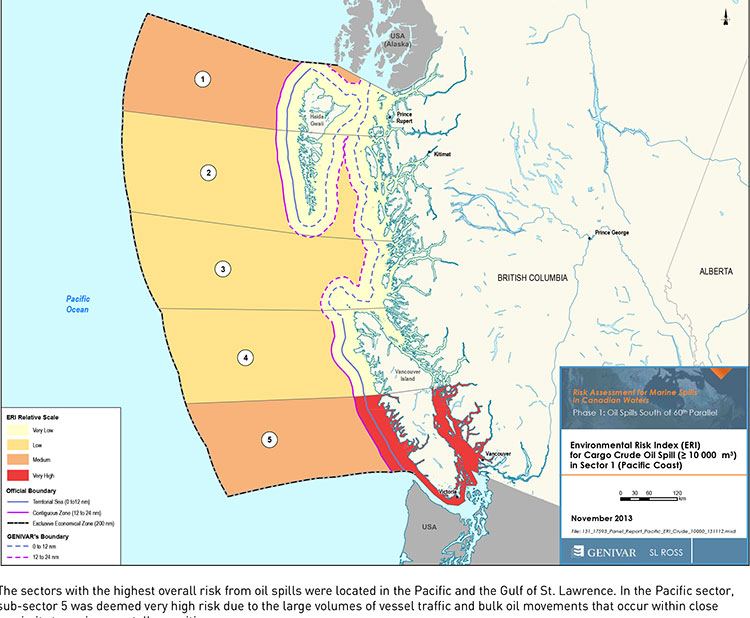
Transport Canada tanker report map shows current risk for spills in BC (Transport Canada)
Cover of Genivar tanker report (Transport Canada)
The possible effects of a bitumen spill on Pacific waters were not considered in the oil response preparedness report released last week by the Harper government, the background data study reveals.
The consulting firm that did the study for Transport Canada, Genivar Inc, had no reliable data on the effect of a bitumen tanker disaster—because, so far, there has been no major ocean disaster involving diluted bitumen.
Instead, Genivar, based its findings on potential hazards and response on existing data on crude oil spills.
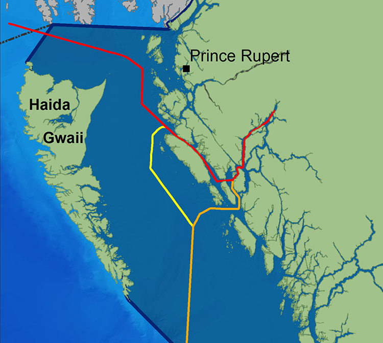
The Genivar study, however, does warn, that if the Enbridge Northern Gateway project does go ahead, the spill risk from diluted bitumen carrying tankers in Douglas Channel and along the north Pacific coast will jump from “low” or “medium” to “very high.” If the twinning of the Kinder Morgan pipeline goes ahead, then the risk in Vancouver also jumps to “very high.”
The question of how bitumen might behave in the cold and choppy waters of the North Pacific was hotly debated during the Northern Gateway Joint Review hearings earlier this year. Enbridge Northern Gateway based its position on laboratory studies, studies that were challenged by environmental and First Nations intervenors, pointing both to the unknowns of the ocean environment and the continuing problems Enbridge has in cleaning up the spill in the Kalamazoo River in Michigan.
The Genivar report, Risk Assessment for Marine Spills in Canadian Waters Phase 1: Oil Spills South of 60th Parallel, was completed in November, then passed on to the “expert panel” that released their own report: A Review of Canada’s Ship-source Oil Spill Preparedness and Response Regime — Setting the Course for the Future. That second report was based not only on the data provided by Genivar but on the expertise of three panel members, their visits to some locations and input from government, industry, First Nations and municipalities.
The actual data report was not posted; it had to be requested through the Transport Canada website, which is how Northwest Coast Energy News obtained the background study.
The expert panel found “a very high risk” of oil spills in two areas of the Pacific Coast, in the north around the ports of Kitimat and Prince Rupert and in the heavy ocean traffic area of southern British Columbia, especially Port Metro Vancouver and into Washington State.
The expert panel made 45 recommendations that covered a wide range of issues including eliminating the present $161-million liability limit for each spill and replacing it with unlimited liability for polluters, annual spill training involving the Canadian Coast Guard, Environment Canada, provincial and local authorities and the private sector, increased and improved annual spill training exercises, basing risk assessment on local geography and conditions and faster emergency responses to spills.
The expert panel calls for greatly increased research on the ocean environment at a time that Harper government has been gutting environmental research across Canada, while spinning that its policies are “science based.”
The science and technology around both the movement of oil and spill response has advanced significantly over the past several decades. We feel that while some aspects of the Regime have kept pace with these developments, in some areas, Canada has fallen behind world-leading countries like Norway and France. This can be attributed to a general lack of investment in research and development as well as the lack of coordination between industry and government over research priorities.
The Government of Canada should work closely with industry to establish a national research and development program for oil spill preparedness and response. The program should be co-funded by industry and the Government, and the research priorities should be set through a collaborative process that involves academia, where possible. Like the Regime itself, we view this program as a partnership between industry and government.
We envision that this program would also seek to leverage the work being done internationally on oil spill preparedness and response. The program should seek to establish partnerships with other world-leading countries in order to stay current on international advances and new technologies.
The expert panel, however, does not say how the federal government is expected to pay for meeting BC Premier Christy Clark’s condition for a “world class” spill prevention and response system at a time that Finance Minister Jim Flaherty is determined to balance the budget and the Harper government is continuing to cut back government services.
Bitumen excluded
On bitumen, the Genivar data study says:
Modified bitumen products represent the majority of the “crude carried as cargo” in
Pacific sub-sector 5. They are not modelled as a separate category in this spill behaviour analysis but are represented as “persistent crude”.
Changes in spill behaviour depend to some extent on the environmental conditions at the time of the spill, as described in greater detail below. However, over the range of wind and sea conditions typically experienced in the Canadian marine environment, changes in oil properties are not overly sensitive to variations in climatic values, so a single set of wind and sea conditions will be used in the analysis.
The idea that “changes in oil properties” not being sensitive to variations in climate was also frequently challenged before the Joint Review Panel.
On the increase in traffic volume if the Northern Gateway project goes ahead, the Genivar report says.
Enbridge Inc. has proposed to construct a marine terminal at Kitimat, B.C. and a dual pipeline from the terminal to oil sands production in northern Alberta. The terminal would handle up to 193,000 barrels/day of imported diluents (i.e., low-gravity condensate) that would be piped to Alberta and used to dilute bitumen to enhance its flow properties. The diluted bitumen would then be piped to Kitimat at rates up to 525,000 barrels/day that would be shipped by tanker to export to markets in Asia and California.
At full capacity, the import of diluent and export of diluted bitumen would total up to 35 Mt/year. This amount is comparable to the currently-shipped volume in the Pacific sector related to volumes being exported from Vancouver and related to volumes being exported from the Alaskan to Washington State trade.
It goes on to say that the current tanker traffic on the north Pacific coast “has negligible risk in the near shore and intermediate zones, but significant potential spill frequency in the deep-sea zone related to the Alaskan trade.” Similarly, according to Genivar the environmental risk in the region “currently ranges from ‘medium’ to “very low” from near shore to deep-sea zones, respectively…. mainly driven by a combination of physical and biological features.”
The increase in traffic from Northern Gateway would likely increase the environmental risks. The the near shore risk from would jump from “very low” to “very high.” For the largest spill category, deep-sea risk would likely increase from “low” to “medium.”
No data on recreational or traditional First Nations fishery
To study the effect on an oil spill on the fishery, Genivar used data from the Department of Fisheries and Oceans as the provinces to gauge “the port value of commercial fishing and the value of the fish, shellfish and aquaculture” in each zone it studied and then compared it to the the national averages for commercial fishery. Those figures included any commercial fishery by First Nations.
But Genivar noted, there is no reliable data on either the recreational fishery or the First Nations traditional, food, social and ceremonial fishery, saying:
It is important to highlight that this indicator does not consider recreational or traditional fishing. The importance of this industry is notable and an oil spill could damage the recreational fishing stock as well. However, the absence of comparable data and the fact that this study is restricted to federal and international data, and some provincial data from Quebec and Ontario for commercial fisheries, limits the ability to include recreational fishing… Nevertheless, as an absolute index, it will provide an overall vulnerability in the event of an oil spill.
The ongoing impact of cutbacks at Fisheries and Oceans has had a continuing impact on the northwest, especially in the controversial halibut recreational fishery, where DFO has admitted that it is basically guessing the size of each year’s recreational halibut catch.
Tourism
Genivar also notes that lack of reliable data on the effect on a oil spill on tourism. The consultants go so far as to say one of the indicators they will use to measure the effect of any oil spill on tourism would come from “data extracted from the 2011 National Household Survey at the census division level and the accommodation and food services data will be used.”
The “National Household Survey” is also known as the long form census and it is the National Household Survey that the Harper government made voluntary rather mandatory, decreasing the reliability of the data. Global News recently analyzed those who had contributed to the survey and found that it poor people, the very rich and people in low population areas were least likely to fill out the voluntary census—which means the data for northwest BC is likely highly unreliable from the 2011 survey even though “The census divisions in coastal regions will be selected for each of the sub-sectors. This method will express the economic vulnerability of each sub-sector to a potential collapse in tourism following a spill.”
Despite the importance of cruise ship traffic on the west coast, Genivar notes, “In Canada, data for passenger vessels were unavailable.”
It also notes that “this study does not specifically take into account national parks and other landmarks, since their influence on tourism is indirectly included in the tourism employment
intensity index” so that Genivar could create what it calls the Human-Use Resource Index (HRI), even though that index appears to be based on incomplete data.
The Genivar report for Transport Canada on oil spills say that some persistent effects can last for more than 40 years, based on a study of a spill in Cape Cod, Massachusetts. The report notes that persistent sub-surface oil is still a problem at Prince William Sound, site of the Exxon Valdez disaster in 1989.
On long-term effects, Genivar reports: “The ingestion of contaminated food (such as oiled mussels), may represent the most important exposure pathway for aquatic fauna during a chronic
phase. Chronic exposure to contaminated sediments is also important for fauna or
vegetation.”
It goes on to stay that “large-scale oil spills might have considerable long-term
consequences on social structure and public health, interfering with traditions and
causing cultural disruptions.”
It appears that in the case of an oil-spill, time may heal some wounds, but not all of them, at least if time is considered within human lifetimes and the lifetimes of other species.
Ecological recovery is measured by how quickly individuals and populations of
species return to pre-spill conditions. It is determined by factors such as oil type,
exposure duration, water temperature, degree of weathering, spill response and the
individual and species-specific life history traits. In most environmental habitats,
recovery is completed within 2-10 years after a spill event, but in some exceptional
cases, such as in salt marshes, effects may be measurable for decades after the
event.
In the case of the Exxon Valdez oil spill in Prince William Sound… in 1989, the persistence of sub-surface oil in sediments and its chronic exposure continues to affect some of the wildlife through delayed population reductions, indirect effects and trophic interactions 20 years beyond the acute phase of the spill.
It then goes on to stay that
Four decades after the oil spill In Wild Harbor (USA), Spartina alterniflora beds had a reduced stem density and biomass and mussels in oiled locations showed decreased growth and filtration rates.
According to a Boston Globe story, published at the time of the Deepwater Horizon oil leak in the Gulf of Mexico, in 2010, the Wild Harbor, an oil barge ran aground near Cape Cod in September, 1969, spilling 200,000 gallons of fuel, some of which is still there.
The Boston Globe story noted:
Today, Wild Harbor looks much like any other Cape Cod marsh, but the oil below the surface affects its resiliency. Fiddler crabs normally burrow deep down, funneling oxygen to the roots of marsh grass. Here, they stop digging when they reach the oil, turn sideways, and burrow back to the surface. They also act “drunk’’ from the oil they ingest, and predators can catch them more easily, research shows.
The Woods Hole Oceanographic Institute has been studying the Wild Harbor spill for the past 40 years.
At a recent conference, Dr. John Teal updated scientists on the “multi-decadal effects” of the Wild Harbor spill. According a blog on the conference:
At the time of the 1969 spill, lobsters, clams, and fish died by the thousands, but most people believed the harm would be temporary, reflecting the conventional wisdom of the time. Barge owners and oil industry experts even told residents that most of the oil would evaporate and any damage would only be short-lived. However, researchers at WHOI were not so sure and immediately began cataloging species and tracking where the oil was and kept at it for years. The researchers understood that the immediate, short term effects of oil pollution were already obvious and fairly well-understood, but that everyone was rather ignorant about the long-term and low-level effects of an oil spill….
Beginning three to five years after the spill, marsh grasses and marsh animals were again occupying most of the oiled area. An observer unfamiliar with Wild Harbor would not have been able to visually detect the oiled areas after just 10 years, and by the second decade after the spill, the marsh’s appearance had returned to normal. However, the WHOI researchers pointed out that for more than a decade after the spill, an oil sheen still appeared on the surface of the water when mud from the most heavily oiled parts of the marsh was disturbed….
In 2007, WHOI researchers documented that a substantial amount of moderately degraded petroleum still remained within the sediment and along eroding creek banks of the marsh oiled in 1969. They also demonstrated that the ribbed mussels that inhabit the oiled salt marsh, and are exposed to the oil, exhibited slower growth rates, shorter mean shell lengths, lower condition indices, and decreased filtration rates even when placed in a healthy marsh. Researchers have also documented detrimental effects of the 1969 oil spill on the salt marsh plants themselves.
Long-term effects on the population in the aquatic environment (especially on mobile fauna) are especially difficult to confirm. Benthic [bottom dwelling] invertebrates may be more at risk than fish species due to the fact that more or less sessile organisms are likely to suffer higher initial rates of mortality and exhibit long recovery times as a result of
exposure to oil-saturated habitats.
Nearshore demersal [bottom-dwelling] fish can also suffer from long-term chronic exposure, as indicated in masked greenlings and crescent gunnels by biomarkers on hydrocarbons 10 years after the Exxon Valdez spill. Mortality in sea ducks and sea turtles due to chronic exposure was also reported many years after the spill and other results indicate that effects on cetacean populations can last beyond 20 years after the acute exposure phase.
As for the recovery of the economy after a spill, Genivar notes it is based “on the time required for effected industries to be fully restored to pre-spill conditions.
The length of time required is influenced by the duration of the aquatic area closures (e.g. commercial fisheries, recreational fisheries), the public perceptions on seafood safety and the perceived effects of the aesthetic quality of the environment. Even after the full ecological recovery of the aquatic resources, fisheries can be far from reestablished, as is still the case for herring fisheries in the Exxon Valdez spill area…
As reviewed by Genivar, negative perceptions associated with the quality of fishery products, even for fisheries that have not been contaminated and also for regions not directly affected by the spill, can be far more important than the direct economic losses. This also holds true for the tourism sector and all other related spinoff sectors.
BC Parks and the Gitga’at First Nation are calling for public input as they development a management plan for the K’nabiyaaxl/Ashdown Island Conservancy at the mouth of Douglas Channel.
BC Parks describes the area as:
K’nabiyaaxl/Ashdown Conservancy covers 727 hectares of marine and uplands ecosystem on the northwest coast of British Columbia, south of Gil Island. The conservancy is 40 kilometres south of Hartley Bay and 120 kilometres southwest of Kitimat. The conservancy is in the traditional territory of the Gitga’at First Nation.
Although not well known outside the Kitimat region, Ashdown Island did receive some measure of fame because it was one of the islands that disappeared from Enbridge’s promotional animation of the tanker route for diluted bitumen from Kitimat to Asia if the controversial Northern Gateway project goes ahead. As well as a haven for wildlife, Ashdown is known as a prime halibut fishing area.
Ashdown Island study area (BC Parks)
Ashdown Island is on the proposed “Southern Approach” for Enbridge’s tanker traffic routes.
The area and nearby waters have been and continue to be intensively used by the Gitga’at people for cultural, social and economic purposes. In Tsimshian language (Sm’algyax), K’nabiyaaxl means “place where cliff” – which is located on the west side of Ashdown Island.
The conservancy encompasses all of Ashdown Island and the foreshore area
and land covered by water within 200 metres of the high tide line. It
has high intertidal values, especially for seaweed, and contains an important
Steller Sea Lion haulout. The waters around the island support important Gitga’at
community fisheries.
Although in Gitga’at traditional territory, the plan notes that the Haisla, the Kitasoo community of Klemtu; and Gitxaala community of Kitkatla on Dolphin Island should be consulted.
It goes on to say:
The conservancy protects an entire small island representative of the Hecate Lowlands Ecosection. The island’s foreshore marine environments include high value intertidal areas which provide high value habitat for important marine wildlife species and migratory birds. The conservancy also protects a haulout for Stellar Sea Lions (Eumetopias jubatus), a species of concern (provincially blue- listed3)…
Stellar Sea Lions use small islets off the south end of Ashdown Island as a winter
haulout, with up to 12 pups and 107 adults observed
The plans lists the Humpback Whale (Blue-listed, S1N); the. Killer Whale (Red- or Blue-listed, S2 or S3 depending on sub-species); and the Fin Whale; as Ashdown Island species at risk. (SARA species schedule procedure site)
As well:
The conservancy contains seven hectares of potential Marbled Murrelet habitat
which, although small, may provide important habitat when combined with core
Marbled Murrelet habitat in nearby areas.
K’nabiyaaxl’s remote location provides an excellent opportunity for maintaining
biological diversity and natural environment values. This habitat should not be
disturbed by conservancy use and development.
The island and the near shore are also part of the Gitga’at’s rich cultural heritage.
The conservancy is near the seasonal Gitga’at village camp of K’yel. The Gitga’at
travel in the spring from Hartley Bay to K’yel, which they use as a base for conducting intensive marine and intertidal harvesting and hunting activity.
Since time immemorial, the Gitga’at people have harvested fish and marine
mammal species in waters adjacent to K’nabiyaaxl. They also collect seaweed,
plants and berries from intertidal and upland areas on the island.
Archaeological sites are known to exist in the area. That the BC Archaeological
Branch does not have archaeological sites registered in the conservancy is not
indicative of the rich history of Gitga’at occupancy and use of K’nabiyaaxl.
The Northern Gateway Joint Review Panel has refused to consider the latest findings from the Department of Fisheries and Ocean on humpback whale critical habitat on the coast of British Columbia, including areas of ocean that could be on the route of tankers carrying diluted bitumen from Kitimat.
On October 21, 2013, Fisheries and Oceans released a report called Recovery Strategy for the North Pacific Humpback Whale (Megaptera novaeangliae) in Canada. The DFO report notes that humpback whales are a species of “special concern” by the Committee on the Status of Endangered Wildlife in Canada.
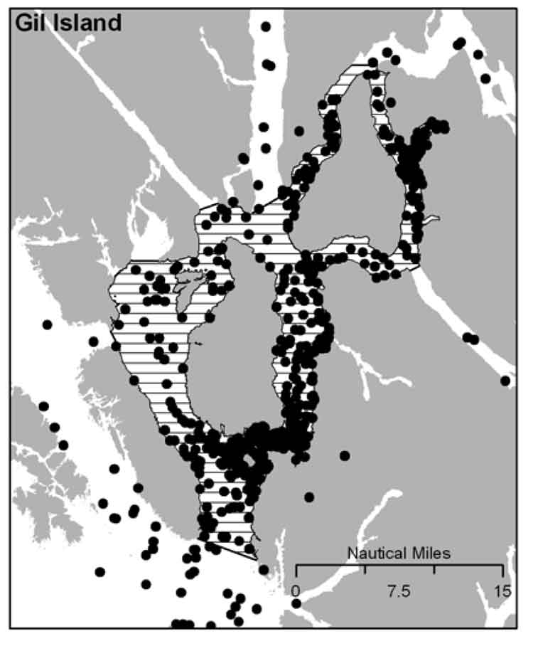
It is DFO policy to assist the humpback whale population to recover from the century of whaling that almost drove the species to extinction. The report identified four areas of “critical habitat” for humpbacks. One critical habitat zone is Gil Island at the mouth of Douglas Channel.
DFO map of humpback sightings on the BC coast. (DFO)
Last week, on November 13, Smithers based environmental activist Josette Weir filed a notice of motion with the JRP requesting that the panel consider the DFO report as late evidence.
Weir acknowledged that the JRP proceedings closed on June 24, after final arguments in Terrace, but she noted that rules allow the Board to override the final closure. She argued that the humpback report fell within the JRP’s mandate since the DFO report is “is likely to assist the Panel.”
Weir noted in her motion that there was insufficient information before the JRP that would identify critical humpback habitat.
She argued:
Three of the four critical known habitats are on the proposed tanker routes, and the Recovery Strategy acknowledges that other areas have not been identified. Without such information, it is impossible to assess the potential effects of the marine transport of bitumen on this endangered species.Activities likely to destroy or degrade critical habitat include vessel traffic, toxic spills, overfishing, seismic exploration, sonar and pile driving (i.e., activities that cause acoustic disturbance at levels that may affect foraging or communication, or result in the displacement of whales).
The report clearly identifies vessel traffic and toxic spills, which are associated with the Project as potential causes for destruction or degradation of the Humpback Whales’ critical habitat.
Weir went on to argue that the JRP had “insufficient information to develop relevant protection measures” because the humpback studies are ongoing, “meaning their results will not be available before decision.”
The Panel must consider this significant risk to an endangered listed species for which no meaningful protection measure can be offered against the risks associated with the Project.
Weir also noted that “No similar submission has been made by others, but I cannot predict if others will not see fit to do so.”
The JRP didn’t take long to reject Weir’s request, replying the next day, November 14.
In its response, the JRP cited the amended Joint Review Panel Agreement, signed after the passage of of the Jobs, Growth and Long-term Prosperity Act, the Omnibus Bill C-38, that “provides that the Panel’s recommendation report is to be submitted to the Minister of Natural Resources by 31 December 2013.”
The JRP then told Weir it didn’t have jurisdiction over endangered species (even if those species inhabit the tanker route) saying:
The Panel notes that the Recovery Strategy has been released in accordance with the provisions of the Species At Risk Act, as part of a legislative scheme that operates independently of this joint review process.
It goes on to say: “In this case, the Panel also notes that the Recovery Strategy was not authored by or for Ms. Wier.”
Humpback whale sightings at the Gil Island critical habitat. (DFO)
The executive summary of the DFO report noted:
Critical habitat for Humpback Whales in B.C. has been identified to the extent possible, based on the best available information. At present, there is insufficient information to identify other areas of critical habitat or to provide further details on the features and attributes present within the boundaries of identified critical habitat. Activities likely to destroy or degrade critical habitat include vessel traffic, toxic spills, overfishing, seismic exploration, sonar and pile driving (i.e., activities that cause acoustic disturbance at levels that may affect foraging or
communication, or result in the displacement of whales). A schedule of studies has been included to address uncertainties and provide further details on the critical habitat feature(s), as well as identify additional areas of critical habitat. It is anticipated that results from these studies will also assist in development of relevant protection measures for the critical habitat feature(s).
In the part of the report on the danger of toxic spills to humpbacks, the DFO report mentions that sinking of the BC ferry Queen of the North:
Toxic spills have occurred impacting marine habitat along the B.C. coast. For example, the Nestucca oil spill (1988) resulted in 875 tonnes of oil spilled in Gray’s Harbor, Washington. Oil slicks from this spill drifted into Canadian waters, including Humpback Whale habitat. In 2006, a tanker ruptured in Howe Sound, B.C. spilling approximately 50 tonnes of bunker fuel into coastal waters. In 2007, a barge carrying vehicles and forestry equipment sank near the Robson Bight-Michael Bigg Ecological Reserve within the critical habitat for Northern Resident Killer Whales, spilling an estimated 200 litres of fuel. The barge and equipment (including a 10,000L
diesel tank) were recovered without incident. When the Queen of the North sank on March 22, 2006, with 225,000 L of diesel fuel, 15,000 L of light oil, 3,200 L of hydraulic fluid, and 3,200 of stern tube oil, it did so on the tanker route to Kitimat, which is currently the subject of a pipeline and port proposal and within the current boundaries of Humpback Whale critical habitat
The DFO report also takes a crtical look at vessel strikes
In B.C. waters, Humpback Whales are the most common species of cetacean struck by vessels, as reported to the Marine Mammal Response Network. Between 2001 and 2008, there were 21 reports of vessel strikes involving Humpback Whales. Of these, 15 were witnessed collision events while the remaining 6 were of live individuals documented with fresh injuries consistent with recent blunt force trauma or propeller lacerations from a vessel strike.
Overall, vessel strikes can cause injuries ranging from scarring to direct mortality of individual whales. Some stranded Humpback Whales that showed no obvious external trauma, have been shown from necropsy to have internal injuries consistent with vessel strikes… It is unknown how many whales have died as a result of vessel strikes in B.C. waters. To date, only one reported dead Humpback Whale presented with evidence consistent with blunt force trauma and lacerations resulting from a vessel strike…
There are no confirmed reports of Humpback Whale collisions in B.C. waters attributed to shipping, cruise ship or ferry traffic. However, larger ships are far less likely to detect the physical impact of a collision than smaller vessels, and this could account for the lack of reported strikes. Collisions with large vessels may be more common than reported, especially in areas where larger vessel traffic is concentrated.
Despite the fact that collisions may only affect a small proportion of the overall Humpback Whale population, vessel strikes may be a cause for concern for some local and seasonal areas of high ship traffic.. In B.C., areas of high probability of humpback-vessel interaction include Johnstone Strait off northeast Vancouver Island, Juan de Fuca Strait off southwest Vancouver Island, Dixon Entrance and the “Inside Passage” off the northern B.C. mainland which include portions of two of the identified critical habitat areas..
The JRP also said
As the Panel has mentioned previously during the hearing, the later in the joint review process that new evidence is sought to be filed the greater the likelihood of the prejudice to parties. The Panel is of the view that permitting the Recovery Strategy to be filed at this late stage in the hearing process would be prejudicial to the joint review process.
Blacked out fishery. A new study says that fisheries protection in Canada is now tied to economics, meaning areas with lower populations, like the BC northwest, get less fisheries protection. (Fisheries magazine)
New regulations under the Fisheries Act that was revised by the Harper government’s omnibus bills go even further in gutting protection for fish habitat in Canada, according to an analysis by scientists released Friday.
The changes to Canada’s fisheries legislation “have eviscerated” the ability to protect habitat for most of the country’s fish species, the scientists, John Post, at the University of Calgary and Jeffrey Hutchings of Dalhousie University say their new study.
The study says with the Conservative government’s emphasis on prioritizing economic importance over the habitat ecology is “contrary to responsible management practices for the protection of native fishes, the act now inadvertently prioritizes habitat protection for some nonnative species—even hatchery-produced hybrids.” The study says as long as those introduced or other species are part of what the new act and regulations define as “part of a fishery,” those fish are protected, while nearby native species, not part of a fishery, have no protection.
The same economic emphasis downgrades protection for sparsely inhabitated regions (which make up most of Canada) through what the scientists call:
NO HUMANS . NO FISHERY; NO FISHERY . NO PROTECTION; NO PROTECTION . NO STEWARDSHIP
The stipulation that fish be part of, or support, a fishery will have particularly egregious consequences for species that inhabit pristine or near-pristine habitat in Canada’s vast wilderness.
Under the revised FA, fish that inhabit lakes, rivers, and streams that are not regularly visited by humans do not warrant protection. Humans are necessary to render a fish part of a fishery. No humans, no fishery, and no fish habitat protection. This can only be interpreted as meaning that the vast majority of Canada’s freshwater fishes will be deemed to not warrant habitat protection under the revised FA, even if those species are considered part of a fishery elsewhere in their range.
The changes were “politically motivated,” unsupported by scientific advice – contrary to the policy of previous governments – and are inconsistent with ecosystem-based management, fisheries biologists Post and Hutchings say.
Their comprehensive assessment, in a peer-reviewed paper titled “Gutting Canada’s Fisheries Act: No Fishery, No Fish Habitat Protection,” is published in the November edition of Fisheries, a journal of the 10,000-member American Fisheries Society.
The 2012 omnibus bill redefined fish habitat to a fishery in this clause:
No person shall carry on any work, undertaking or activity that results in serious harm to fish that are part of a commercial, recreational or Aboriginal fishery, or to fish that support such a fishery.
The two authors interpret that as meaning, that while you may be forbidden from harming the fish, there are no barriers to harming fish habitat.
… it will no longer be illegal to harmfully alter or disrupt fish habitat. The revised act only renders it illegal to cause serious harm to fish that are part of a commercial, recreational, or Aboriginal fishery or to fish that support such a fishery. “Serious harm” is defined by the act as “the death of fish or any permanent alteration to, or destruction of, fish habitat” (Fisheries Act 2013). A legal opinion prepared for the Environmental Managers Association of British Columbia concluded that serious harm does not prohibit the disruption or temporary alteration of fish habitat, concluding that many situations prohibited under the previous legislation will no longer be covered by the revised act
The new regulations proclaimed in the Canada Gazette in April 2013.
“The biggest change is that habitat protection has been removed for all species other than those that have direct economic or cultural interests, through recreational, commercial and Aboriginal fisheries,” Post says.
Before, “there used to be a blanket habitat protection for all fish species,” he says. “Now there’s a projection just for species of economic importance which, from an ecological standpoint, makes no sense.”
The study goes on to say:
The near elimination of fish habitat protection represents a clear signal that protection of habitat—the single greatest factor responsible for the decline and loss of commercial and noncommercial species on land and in water —no longer merits explicit protection under Canadian fisheries management law.
And later:
The multitude of aquatic systems that do not support a fishery, coupled with the extensive distributions of many Canadian fishes, will mean that habitat protection will not be provided for most fish species in most places.
By applying the “no humans, no fishery” criterion, the Minister of Fisheries and Oceans will have an easy time expediting applications for fish habitat destruction resulting from all manner of development. The lack of foresight inherent in the “no humans, no fishery” stipulation is also manifest by the likelihood that aquatic systems that do not support a fishery today (e.g., much of Arctic and northern Canada) might well do so in the future. But investment in future fisheries requires investment in appropriate habitat protection today. How is a fishery to develop down the road if the habitat is already gone?
Although it is well known that the Harper government muzzles scientists from speaking to the media, that apparently doesn’t mean that there isn’t “chatter” (to use the intelligence term) among fisheries scientists themselves. As the study authors report:
based on personal communications with DFO scientists and divisional managers, it appears that scientists were not consulted at all. By all accounts, DFO scientists and managers were surprised by the degree and types of changes in the revised act. According to one very highly placed science director (in a confidential communication to one of the authors), he was unaware of the March 2012 provisions in the legislation until he heard of the government’s finalized revisions on a news broadcast.
The scientists also quote earlier studies that showed the old Fisheries Act was not unduly holding up development projects.
a key reason for revising the act—a perceived need to expedite or “streamline” environmental reviews (Canada Gazette 2013)—has been shown to lack an empirical basis. There was a perception among some politicians that the act needed to be changed because it was deemed unduly obtrusive and prevented any number of activities from occurring.
The analysis by the environmental group Ecojustice showed that between 2006 and 2011, only one proposal among thousands was denied by the DFO, and only 1.6% of 1,283 convictions under the FA between 2007 and 2011 pertained to the destruction of fish habitat.
Post and Hutchings go on to say:
These scientific analyses run counter to the political discourse, which argues that environmental reviews are unduly lengthy and are bad for economic growth. In fact, review times in Canada were found to be faster, under the previous Fisheries Act, than they were in the United States. The absence of a scientific basis for statutory change in this case is a telling example of how scientific advice can constructively assist decision makers before they revise legislation.
Proponent gets to gather the data
University of Calgary fisheries biologist John Post. (Riley Brandt, University of Calgary)
Under the new regulations proclaimed in April, when an individual or company applies for an “application to undertake an activity that requires authorization by the Minister of Fisheries and Oceans” …”the primary—if not sole—responsibility for providing accurate information and data rests with the applicant, rather than with DFO habitat scientists and biologists.”
The proponent of a project has to identify whether or not “fish that are part of a commercial, recreational or Aboriginal fishery,” or “fish that support such a fishery,” at the location of the proposed work, will be the responsibility of the proponent/applicant to identify.
The two scientists say there is no way to ask what scientific standards, DFO’s or others will be applied in identifying fish that support a fishery.
There are also questions about who “will determine the scientific validity and appropriateness of each proponent’s assessment.” It could be, the paper says, the proponent themselves determining the validity of their own studies because:
There does not appear to be a requirement for the DFO to undertake an on-site inspection by DFO scientific staff to verify information provided by an applicant. This change in responsibility explains the 33% reduction in DFO staff responsible for habitat protection reported by various Canadian media in 2012. This reduction in staff can only diminish the scientific integrity and scientific credibility of DFO’s assessments of applications for the authorization of activities under 35(2)(b) of the FA that will result in the destruction of fish and fish habitat.
The study goes on to say:
The regulations confirm that the revised FA will not protect any particular species of fish. Rather, protection will be provided only to “fish that are part of a commercial, recreational or Aboriginal fishery” or “fish that support such a fishery.” This means, to take one of many examples, that Largemouth Bass (Micropterus salmoides) will be protected at a particular location if, and only if, those Largemouth Bass are considered to be part of a fishery at that location. Otherwise, Largemouth Bass will not be protected.
The scientists do acknowledge that:
It can be argued that there are positive elements to the FA revisions, such as (1) statutory recognition of the importance of recreational and Aboriginal fisheries, (2) provision for the establishment of regulations to control aquatic invasive species and prohibit their import, and (3) increased penalties and fines for contravention of the act.
They then add:
But, in our opinion, the negative consequences to Canada’s aquatic ecosystems generated by the revisions to the act outweigh these benefits, none of which actually required changes to the existing habitat protection provisions of the FA.
The scientists conclude the article by saying
Being the second largest country in the world, Canada is responsible for 20% of the globe’s fresh water, one third of its boreal forests and associated aquatic environment, and the world’s longest coastline. However, this geographical wealth comes with a responsibility to be internationally respected stewards of this vast environment. Politically motivated abrogation of the country’s national and international responsibilities to protect fish and fish habitat suggests to us that Canada might no longer be up to the task.
Special report: Clio Bay cleanup: Controversial, complicated and costly
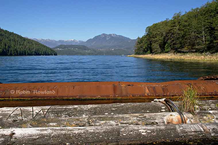
Clio Bay, looking toward Douglas Channel, September 14, 2013. (Robin Rowland/Northwest Coast Energy News)
Haisla First Nation Chief Counsellor Ellis Ross says the Haisla made the proposal to the KM LNG project, a partnership of Chevron and Apache, to use the marine clay to cover the thousands of logs at the bottom of Clio Bay after years frustration with the Department of Fisheries and Oceans and the BC provincial government, which for decades ignored requests for help in restoring almost fifty sunken log sites in Haisla traditional territory.
The problem is that remediation of the hundreds of sites on Canada’s west coast most containing tens of thousands of sunken logs has been so low on DFO’s priority list that even before the omnibus bills that gutted environmental protection in Canada, remediation of sunken log sites by DFO could be called no priority.
Now that the KM LNG has to depose of a total of about 3.5 million cubic metres of marine clay and possibly other materials from the Bish Cove site, suddenly log remediation went to high priority at DFO.
The controversy is rooted in the fact that although the leaders of the Haisla and the executives at Chevron knew about the idea of capping Clio Bay, people in the region, both many residents of Kitimat and some members of the Haisla were surprised when the project was announced in the latest KM LNG newsletter distributed to homes in the valley.
Chevron statement
In a statement sent to Northwest Coast Energy News Chevron spokesperson Gillian Robinson Ridell said:
The Clio Bay Restoration Project proposed by Chevron, is planned to get underway sometime in early 2014. The proposal is fully supported by the Federal Department of Fisheries and Oceans and the Haisla First Nation Council. The project has been put forward as the best option for removal of the marine clay that is being excavated from the Kitimat LNG site at Bish Cove. Chevron hired Stantec, an independent engineering and environmental consulting firm with extensive experience in many major habitat restoration projects that involve public safety and environmental conservation. The Haisla, along with Stantec’s local marine biologists, identified Clio Bay as a site that has undergone significant environmental degradation over years of accumulation of underwater wood debris caused by historic log-booming operations. The proposal put forward by the marine biologists was that restoration of the marine ecosystem in the Bay could be achieved if marine clay from Chevron’s facility site, was used to cover the woody debris at the bottom of the Bay. The process outlined by the project proposal is designed to restore the Clio Bay seafloor to its original soft substrate that could sustain a recovery of biological diversity.
Kitimat worried
Non-aboriginal residents of Kitimat are increasingly worried about being cut off from both Douglas Channel and the terrestrial back country by industrial development. These fears have been heightened by reports that say that Clio Bay could be closed to the public for “safety reasons” for as much as 16 months during the restoration project.
The fact that Clio is known both as a safe anchorage during bad weather and an easy to get to location for day trips from Kitimat has made those worries even more critical.
There is also a strong feeling in Kitimat that the residents were kept out of the loop when it came to the Clio Bay proposal.
In a letter to the District of Kitimat, DFO said:
Clio Bay has been used as a log handling site for decades which has resulted in areas of degraded habitat from accumulations of woody debris materials on the sea floor. The project intends to cap impacted areas with inert materials and restore soft substrate seafloor. The remediation of the seafloor is predicted to enhance natural biodiversity and improve the productivity of the local fishery for Dungeness crab. The project area does support a variety of life that will be impact and therefore the project will require authorization from Fisheries and Oceans Canada for the Harmful Alteration, Disruption or Destruction (HADD) of fish and fish habitat.
The letter avoids the controversy over the use of marine clay but saying “inert material” will be used. That can only increase the worries from residents who say that not only clay but sand, gravel and other overburden from Bish Cove and the upgrade of the Forest Service Road may be used in Clio Bay. (The use of “inert material” also gives DFO an out if it turns out the department concludes the usual practice of using sand is better. That, of course, leaves the question of what to do with the clay).
Although Ellis Ross has said he wants to see large numbers of halibut and cod return to Clio Bay, the DFO letter only mentions the Dungeness Crab.
DFO website cites pending changes after the passage of the omnibus bills.
Try to search “remediation” on the DFO site and the viewer is redirected to a page that cites the omnibus bills passed by the Conservative government and says
On June 29, 2012, the Fisheries Act was amended. Policy and regulations are now being developed to support the new fisheries protection provisions of the Act (which are not yet in force). The existing guidance and policies continue to apply. For more information, see Changes to the Fisheries Act.
On April 2nd, 2013 the Habitat Management Program’s name was changed to the Fisheries Protection Program.
So, despite what communications officers for DFO and the Harper government may say, there was no policy then and there is no policy now on remediation of log sites. Given Harper’s attitude that LNG and possibly bitumen export must proceed quickly with no environmental barriers, it is likely that environmental remediation will continue to be no priority—unless remediation becomes a problem that the energy giants have to solve and pay for.
Alaska studies
On the other hand, the State of Alaska and the United States Environmental Protection Agency spent a decade at a site near Ketchikan studying the environmental problems related to sunken logs at transfer sites
Those studies led Alaska to issue guidelines in 2002 with recommended practices for rehabilitating ocean log dump sites and for the studies that should precede any remediation project.
The Alaska studies also show that in Pacific northwest coast areas, the ecological effects of decades of log dumping, either accidental or deliberate, vary greatly depending on the topography of the region, the topography of the seabed, flow of rivers and currents as well as industrial uses along the shoreline.
The Alaska policy is based on studies and a remediation project at Ward Cove, which in many ways resembles Clio Bay, not far from Kitimat, near Ketchikan.
The Alaska policy follows guidelines from both the US Environmental Protection Agency and the US Army Corps of Engineers that recommend using thin layers of “clean sand” as the best practice method for capping contaminated sites. (The Army Corps of Engineers guidelines say that “clay balls” can be used to cap contaminated sites under some conditions. Both a spokesperson for the Corps of Engineers and officials at the Alaska Department of Environmental Conservation told Northwest Coast Energy News that they have no records or research on using marine clay on a large scale to cap a site.)
The EPA actually chose Sechelt, BC, based Construction Aggregates to provide the fine sand for the Ward Cove remediation project. The sand was loaded onto 10,000 tonne deck barges, hauled up the coast to Ward Cove, offloaded and stockpiled then transferred to derrick barges and carefully deposited on the sea bottom using modified clam shell buckets.
The EPA says
Nearly 25,000 tons of sand were placed at the Ward Cove site to cap about 27 acres of contaminated sediments and 3 other acres. In addition, about 3 acres of contaminated sediments were dredged in front of the main dock facility and 1 acre was dredged near the northeast corner of the cove. An additional 50 acres of contaminated sediments have been left to recover naturally.
A report by Integral Consulting, one of the firms involved at the project estimated that 17,800 cubic metres of sand were used at Ward Cove.
In contrast, to 17,800 cubic metres of sand used at Ward Cove, the Bish Cove project must dispose of about 1.2 million cubic metres of marine clay at sea (with another 1.2 million cubic metres slated for deposit in old quarries near Bees Creek).
Studies at Ward Cove began as far back as 1975. In 1990 Alaska placed Ward Cove on a list of “water-quality limited sites.” The studies intensified in 1995 after the main polluter of Ward Cove, the Ketchikan Paper Company, agreed in a consent degree on a remediation plan with the Environmental Protection Agency in 1995. After almost five years of intensive studies of the cove, the sand-capping and other remediation operations were conducted from November 2000 to March 2001. A major post-remediation study was carried out at Ward Cove in 2004 and again in 2009. The next one is slated for 2015.
Deaf ears at DFO
“We need to put pressure on the province or Canada to cleanup these sites. We’ve been trying to do this for the last 30 years. We got nowhere,” Ellis Ross says. “Before when we talked [to DFO] about getting those logs and cables cleaned up, it fell on deaf ears. They had no policy and no authority to hold these companies accountable. So we’re stuck, we’re stuck between a rock and hard place. How do we fix it?”
Ross says there has been one small pilot project using marine clay for capping which the Haisla’s advisers and Chevron believe can be scaled up for Clio Bay.
Douglas Channel studies
The one area around Kitimat that has been studied on a regular basis is Minette Bay. The first study occurred in 1951, before Alcan built the smelter and was used as a benchmark in future studies. In 1995 and 1996, DFO studied Minette Bay and came to the conclusion that because the water there was so stagnant, log dumping there had not contributed to low levels of dissolved oxygen although it said that it could not rule out “other deleterious effects on water quality and habitat`from log dumping.”
That DFO report also says that there were complaints about log dumping at Minette Bay as far back as 1975, which would tend to confirm what Ross says, that the Haisla have been complaining about environmentally degrading practices for about 30 years.
Ross told Northwest Coast Energy News that if the Clio Bay remediation project is successful, the next place for remediation should be Minette Bay.
A year after the Minette Bay study, DFO did a preliminary study of log transfer sites in Douglas Channel, with an aerial survey in March 1997 and on water studies in 1998. The DFO survey identified 52 locations with sunken logs on Douglas Channel as “potential study sites.” That list does not include Clio Bay. On water studies were done at the Dala River dump site at the head of the inlet on Kildala Arm, Weewanie Hotsprings, at the southwest corner of the cove, the Ochwe Bay log dump where the Paril River estuary opens into the Gardner Canal and the Collins Bay log dump also on the Gardner Canal.
In the introduction to its report, published in 2000, the DFO authors noted “the cumulative effect of several hundred sites located on BC coast is currently unknown.”
Since there appears to have been no significant follow-up, that cumulative effect is still “unknown.”
In 2000 and 2001, Chris Picard, then with the University of Victoria, now Science Director for the Gitga’at First Nation did a comparison survey of Clio Bay and Eagle Bay under special funding for a “Coasts Under Stress” project funded by the federal government. Picard’s study found that Eagle Bay, where there had been no log dumping was in much better shape than Clio Bay. For example, Picard’s study says that “Dungeness crabs were observed five times more often in the unimpacted Clio Bay.”
Although low oxygen levels have been cited as a reason for capping Clio Bay, Picard’s study says that “near surface” oxygen levels “did not reliably distinguish Clio and Eagle Bay sediments.” While Clio Bay did show consistent low oxygen levels, Eagle Bay showed “considerable interseasonal variation” which is consistent with the much more intensive and ongoing studies of oxygen levels at Wards Cove.
Chevron’s surprise
It appears that Chevron was taken by surprise by the controversy over the Clio Bay restoration. Multiple sources at the District of the Kitimat have told Northwest Coast Energy News that in meetings with Chevron, the company officials seemed to be scrambling to find out more about Clio Bay.
This is borne out by the fact, in its communications with Northwest Coast Energy News, Chevron says its consulting firm, Stantec has cited just two studies, Chris Picard’s survey of Clio Bay and a 1991 overview of log-booming practices on the US and Canadian Pacfic coasts. So far, Chevron has not cited the more up-to-date and detailed studies of Ward Cove that were conducted from 1995 to 2005.
Chevron says that Stantec marine biologists are now conducting extensive field work using divers and Remote Operated Vehicle surveys to “observe and record all flora and fauna in the bay and its levels of abundance. Stantec’s observations echoed the previous studies which determined that the massive amount of wood has harmed Clio Bay’s habitat and ecosystem.”
In its statement to Northwest Coast Energy News, Chevron cited its work on Barrow Island, in Western Australia, where the Chevron Gordon LNG project is on the same island as a highly sensitive ecological reserve.Chevron says the Australian site was chosen only after a thorough assessment of the viability of other potential locations, and after the implementation of extensive mitigation measures, including a vigorous quarantine program for all equipment and materials brought on to the Barrow island site to prevent the introduction of potentially harmful alien species.
Reports in the Australian media seem to bare out Chevron’s position on environmental responsibility. Things seem to be working at Barrow Island.
Robinson went on to say:
Those same high environmental standards are being applied to the Kitimat LNG project and the proposed Clio Bay Restoration project. The proposed work would be carried out with a stringent DFO approved operational plan in place and would be overseen by qualified environmental specialists on-site.
The question that everyone in the Kitimat region must now ask is just how qualified are the environmental specialists hired by Chevron and given staff and budget cuts and pressure from the Prime Minister’s Office to downgrade environmental monitoring just how stringent will DFO be monitoring the Clio Bay remediation?
Alaska standardsIn the absence of comprehensive Canadian studies, the only benchmark available is that set by Alaska which calls for:Capping material, typically a clean sand, or silty to gravelly sand, is placed on top of problem sediments. The type of capping material that is appropriate is usually determined during the design phase of the project after a remediation technology has been selected. Capping material is usually brought to the site by barge and put in place using a variety of methods, depending on the selected remedial action alternative.
Thick Capping
Thick capping usually requires the placement of 18 to 36 inches of sand over the area. The goal of thick capping is to isolate the bark and wood debris and recreate benthic habitat that diverse benthic infauna would inhabit.
Thin Capping
Thin capping requires the placement of approximately 6 – 12 inches of sand on the project area. It is intended to enhance the bottom environment by creating new mini-environments, not necessarily to isolate the bark and wood debris. With thin capping, surface coverage is expected to vary spatially, providing variable areas of capped surface and amended surface sediment (where mixing between capping material and problem sediment occurs) as well as limited areas where no cap is evident.
Mounding
Mounding places small piles of sand or gravel dispersed over the waste material to create habitat that can be colonized by organisms. Mounding can be used where the substrate will not support capping.