Enbridge’s Michigan cleanup costs now exceed JRP pipeline conditions for Gateway, SEC filing shows

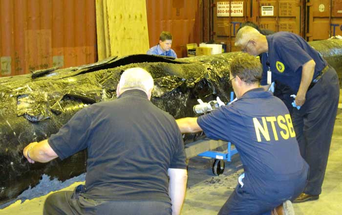
NTSB staff examine ruptured pipe
US National Transportation Safety Board staff examine a ruptured pipe from the Enbridge oil spill in August, 2010. The photo was released by the NTSB May 21, 2012. (NTSB)

The costs for Enbridge to clean up the 2010 Marshall, Michigan oil spill now far exceeds the maximum estimate that the Joint Review Panel gave for a major spill on the Northern Gateway Pipeline and also exceeds the amount of money the JRP ordered Enbridge to set aside to deal with a spill. Enbridge’s cleanup costs have also now edged past the higher liability amount requested by the Haisla Nation.

According to the US firm Enbridge Energy Partners’ filing with the United States Securities and Exchange Commission, as of September 30, 2013, the cost of cleanup was $1.035 billion US, not including possible additional fines and penalties that might be imposed by US authorities in the future.

In its decision, the Joint Review Panel estimated the cost a major oil spill from the Northern Gateway project would be about $693 million.  As part of the 209 conditions, the JRP ordered Enbridge to set aside “financial assurances” totaling $950 million.

Note all costs in this article are for a pipeline breach. The Joint Review Panel had different estimates for a tanker spill and the liability rules for marine traffic are different from pipelines.

In its filing for the third quarter of 2013, with the SEC, Enbridge Energy Partners say that the cost up until September 2013 had “exceed[ed] the limits of our insurance coverage.” The same filing says that Enbridge is in a legal dispute with one its insurers.

In its SEC filing, Enbridge says:

Lakehead Line 6B Crude Oil Release
We continue to perform necessary remediation, restoration and monitoring of the areas affected by the Line 6B crude oil release. All the initiatives we are undertaking in the monitoring and restoration phase are intended to restore the crude oil release area to the satisfaction of the appropriate regulatory authorities.
As of September 30, 2013, our total cost estimate for the Line 6B crude oil release is $1,035.0 million, which is an increase of $215.0 million as compared to December 31, 2012. This total estimate is before insurance recoveries and excluding additional fines and penalties which may be imposed by federal, state and local governmental agencies, other than the Pipeline and Hazardous Materials Safety Administration, or PHMSA, civil penalty of $3.7 million, we paid during the third quarter of 2012. On March 14, 2013, we received an order from the EPA, or the Environmental Protection Agency, which we refer to as the Order, that defined the scope which requires additional containment and active recovery of submerged oil relating to the Line 6B crude oil release. We submitted our initial proposed work plan required by the EPA on April 4, 2013, and we resubmitted the workplan on April 23, 2013. The EPA approved the Submerged Oil Recovery and Assessment workplan, or SORA, with modifications on May 8, 2013. We incorporated the modification and submitted an approved SORA on May 13, 2013. The Order states that the work must be completed by December 31, 2013.

The $175.0 million increase in the total cost estimate during the three month period ending March 31, 2013, was attributable to additional work required by the Order. The $40.0 million increase during the three month period ending June 30, 2013 was attributable to further refinement and definition of the additional dredging scope per the Order and associated environmental, permitting, waste removal and other related costs. The actual costs incurred may differ from the foregoing estimate as we complete the work plan with the EPA related to the Order and work with other regulatory agencies to assure that our work plan complies with their requirements. Any such incremental costs will not be recovered under our insurance policies as our costs for the incident at September 30, 2013 exceeded the limits of our insurance coverage.

According to the SEC filing, the breakdown of costs include $2.6 million paid to owners of homes adversely impacted by the spill.

Despite the efforts we have made to ensure the reasonableness of our estimates, changes to the recorded amounts associated with this release are possible as more reliable information becomes available. We continue to have the potential of incurring additional costs in connection with this crude oil release due to variations in any or all of the categories described above, including modified or revised requirements from regulatory agencies in addition to fines and penalties as well as expenditures associated with litigation and settlement of claims.
The material components underlying our total estimated loss for the cleanup, remediation and restoration associated with the Line 6B crude oil release include the following:
(in millions)

Response Personnel & Equipment  $454

Environmental Consultants  $193

Professional, regulatory and other $388

Total $ 1,035

For the nine month periods ended September 30, 2013 and 2012, we made payments of $62.3 million and $120.9 million, respectively, for costs associated with the Line 6B crude oil release. For the nine month period ended September 30, 2013, we recognized a $2.6 million impairment for homes purchased due to the Line 6B crude oil release which is included in the “Environmental costs, net of recoveries” on our consolidated statements of income. As of September 30, 2013 and December 31, 2012, we had a remaining estimated liability of $265.9 million and $115.8 million, respectively.

As for insurance, Enbridge Energy Partners say:

The claims for the crude oil release for Line 6B are covered by the insurance policy that expired on April 30, 2011, which had an aggregate limit of $650.0 million for pollution liability. Based on our remediation spending through September 30, 2013, we have exceeded the limits of coverage under this insurance policy. During the third quarter 2013, we received $42.0 million of insurance recoveries for a claim we filed in connection with the Line 6B crude oil release and recognized as a reduction to environmental cost in the second quarter of 2013. We recognized $170.0 million of insurance recoveries as reductions to “Environmental costs, net of recoveries” in our consolidated statements of income for the three and nine month periods ended September 30, 2012 for the Line 6B crude oil release. As of September 30, 2013, we have recorded total insurance recoveries of $547.0 million for the Line 6B crude oil release, out of the $650.0 million aggregate limit. We expect to record receivables for additional amounts we claim for recovery pursuant to our insurance policies during the period that we deem realization of the claim for recovery to be probable.

In March 2013, we and Enbridge filed a lawsuit against the insurers of our remaining $145.0 million coverage, as one particular insurer is disputing our recovery eligibility for costs related to our claim on the Line 6B crude oil release and the other remaining insurers assert that their payment is predicated on the outcome of our recovery with that insurer. We received a partial recovery payment of $42.0 million from the other remaining insurers and have since amended our lawsuit, such that it now includes only one insurer. While we believe that our claims for the remaining $103.0 million are covered under the policy, there can be no assurance that we will prevail in this lawsuit.


The Joint Review, Enbridge and Michigan

The Joint Review Panel based its finding on the Marshall, Michigan spill on the figure of $767 million from the summer of 2012 –again showing the limitations of the JRP’s evidentiary deadlines since the costs are now much higher.

The JRP quoted Enbridge as saying:

Northern Gateway considered the high costs of the Marshall, Michigan spill, which were at least $252,000 per cubic metre ($40,000 per barrel), to be an outlier or a rare event because the spill occurred in a densely populated area, because the pipeline’s response time was abnormally long, and because there was the prospect of potentially lengthy legal proceedings.

Enbridge assured the JRP that the corporate culture and management changes and equipment upgrades since the Marshall, Michigan spill lowered that chances of a similar event.

The company based its models for the JRP on much smaller spills, including one spill at Lake Wabamun, Alberta from a train not a pipeline (Vol. 2 p 357)

Enbridge’s risk assessment did not “generate an estimate of economic losses caused
by a spill.”

The JRP says Northern Gateway relied on its analysis of literature, and spill events experienced by Enbridge and other liquid hydrocarbon carriers in Alberta and British Columbia. After assessing all of this information, Northern Gateway regarded the high costs of a cleanup as “conservative”–meaning the company expects costs to be lower than its estimates in evidence before the JRP.

In Northern Gateway’s view the most costly pipeline spill incident would be a full-bore oil pipeline rupture, with an estimated cost of $200 million, and an extremely low probability of occurrence.

Haisla evidence

In their evidence, the Haisla (and other First Nations and intervenors) were doubtful about Northern Gateway’s assurances. The Haisla asked that Enbridge have a minimum of $1 billion in liability, an amount Enbridge has now exceeded in Michigan.

Haisla Nation estimated the cost of damage to ecosystem services because of a terrestrial oil spill from Northern Gateway’s pipeline would be in the range of $12,000 to $610 million for a 30-year period.

The Haisla’s cost estimates were based on values for environmental goods and services and probabilities of spills that were independent of Northern Gateway’s parameters for estimating oil spill costs. In contrast to Northern Gateway’s estimated spill frequency and costs, the Haisla predicted that spills would occur more often and placed a higher value on damages to environmental goods and services.

Haisla Nation argued that Northern Gateway overestimated its ability to detect and respond to a spill. In the Haisla’s view this resulted in the cost of a spill and the requisite financial assurances being understated. Haisla cited several factors, including: remote location, limited access, challenging terrain, seasonal conditions, and river flow conditions that would cause the cost of cleaning up a spill in the Kitimat River valley to be significantly greater than the costs associated with Enbridge’s Marshall, Michigan spill.

For these reasons, Haisla proposed that Northern Gateway should be required to obtain a minimum of $1 billion of liability coverage through insurance and financial assurances. Haisla said that Northern Gateway should file annually the report from an independent third party assessing the financial assurances plan. (Vol 2 p359)

In response Northern Gateway said:

Northern Gateway said that Haisla’s findings were based on a number of fundamental methodological flaws and a lack of probability analysis to support the high frequency of occurrence of oil spill events. Northern Gateway argued that Haisla’s estimates of ecosystem service values were inflated because they were based on values from unrelated studies. In Northern Gateway’s view, Haisla relied on high passive use values that were not justified.

JRP ruling

As it has in most of its decision, the JRP accepted Northern Gateway’s evidence, including its explanation of the Marshall, Michigan spill and then went on to base its spill cost estimates not on a pipeline breach but on the 2005 railway spill at Lake Wabumum, near White Sands, Alberta.

The Panel accepts that the cleanup costs for the Marshall, Michigan spill were orders of magnitude higher because of the extended response time. In this application, the Panel accepts Northern Gateway’s commitment to complete the shutdown in no more than 13 minutes after detection. For this reason the Panel did not use the Marshall spill costs in its calculations. The spill volume and the resulting costs are directly dependent on the Northern Gateway’s control room staff and the pipeline control system fully closing the adjacent block valves no longer than 13 minutes from the detection of an alarm event, as well as the amount of oil which would drain out of the pipeline after valve closure due to elevation differences.

The Panel decided on a total unit cost of $138,376 per cubic metre ($22,000 per barrel). This is midway between the unit cost of $88,058 per cubic metre ($14,000) per barrel proposed by Northern Gateway and the unit cost of $188,694 per cubic metre ($30,000 per barrel) for the Lake Wabamun spill. It is about one-half of the Marshall spill’s unit cost. Giving weight to the Lake Wabamun costs recognizes actual costs experienced in a Canadian spill and the greater costs of spills in high consequence areas. In these areas, individuals, populations, property, and the environment would have a high sensitivity to hydrocarbon spills. The deleterious effects of the spill would increase with the spill volume, the extent of the spill, and the difficulty in accessing the spill area for cleanup and remediation.

Using these spill volume and unit cost values in the calculation below, the Panel estimated the total cost of a large spill could be $700 million. Total cost of a spill = 31,500 barrels x $22,000 per barrel = $693 million, or $700 million when rounded up.

(p362)

The Panel based the financial assurances requirements for Northern Gateway on a spill with a total estimated cost of $700 million and directs Northern Gateway to develop a financial assurances plan with a total coverage of $950 million that would include the following components:
i. Ready cash of $100 million to cover the initial costs of a spill;
ii. Core coverage of $600 million that is made up of stand-alone, third party liability insurance and other appropriate financial assurance instruments, and
iii. Financial backstopping via parental, other third party guarantees, or no fault insurance of at least $250 million to cover costs that exceed the payout of components i. and ii.
The financial backstopping would be available to fill the gap if the spill volumes or unit costs were under-estimated or if the payout from the core coverage would be less than 100 per cent.

The Panel noted that:

The evidence indicates that there is some probability that a large oil spill may occur at some time over the life of the project. In these circumstances the Panel must take a careful and precautionary approach because of the high consequences of a large spill. The Panel has decided that Northern Gateway must arrange and maintain sufficient financial assurances to cover potential risks and liabilities related to large oil spills during the operating life of the project.

Northern Gateway committed to investing $500 million in additional facilities and mitigation measures such as thicker wall pipe, more block valves, more in-line inspections, and complementary leak detection systems. This initiative should enhance the safety and reliability of the system and help reduce and mitigate the effects of a spill, but it would not eliminate the risk or costs of spills. This initiative is not a direct substitute for third party liability insurance and does not eliminate the need for liability insurance or any other form of financial assurance to cover the cost of a spill. (p 361)

So the JRP decision comes down to this, if you accept Northern Gateway’s position that pipeline spills are rare and mostly small, then the company has the financial resources to cover the damage. If, however, Northern Gateway is wrong and the costs of a pipeline cleanup exceed the $950 million required by the Joint Review Panel, as has happened in Michigan, then those JRP conditions are already obsolete.

(Northwest Coast Energy News encourages all readers to read the complete JRP report  and SEC filing since space and readability does not permit fully quoting from the report)
Enbridge misses deadline to clean up Michigan’s Morrow Lake; EPA cites reluctance to do winter cleanup

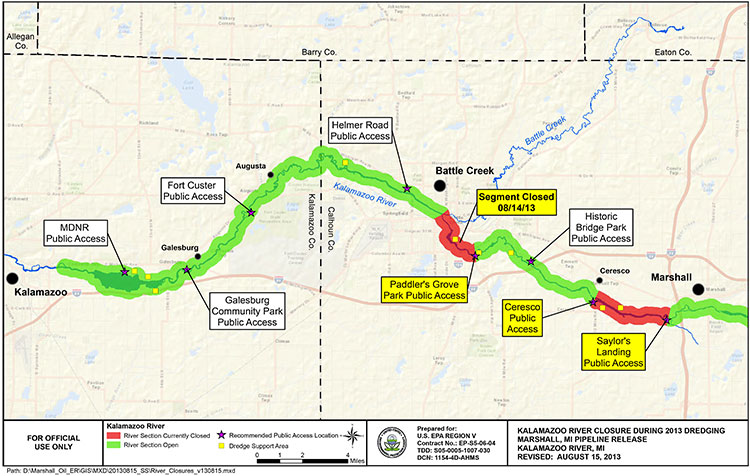
EPA map of Kalamazoo River
EPA map of river closures and dredging operations on the Kalamazoo River during 2013. (EPA)

Enbridge has missed the US Environmental Protection Agency’s deadline to clean up parts of the Marshall, Michigan bitumen spill by December 31, 2013.

Local television news, WOOD-TV says the EPA is now considering “enforcement options.”
The EPA had already granted Enbridge a 10 month extension that the company requested in March, 2013, setting the new December deadline.

In November, Enbridge requested a second extension. The EPA denied that request.

From the EPA letter it appears that, as in previous years, Enbridge is trying to avoid continuing clean up work into the winter. The EPA rejects that position, telling Enbridge it shouldn’t wait until the spring run off could spread the sunken bitumen.

The EPA says that beginning in March, 2013, “Enbridge has successfully removed oil and sediment from two of the three major impoundment areas identified in the order and from several smaller sediment trap locations.”

The area that Enbridge failed to clean up is known as the Morrow Lake and Morrow Lake Delta. The cleanup in that area was delayed when the Comstock Township planning commission unanimously  denied Enbridge a permit for “dredge pad” after fierce public opposition

The letter to Enbridge, from Jeffrey Kimble, Federal On-Scene Coordinator denying the extension is another scathing indictment of Enbridge’s attitude toward the public and the cleanup, citing Enbridge failing to prepare “adequate contingency plans,” by failing to recognize the “serious opposition” the dredging plans.

Although the EPA had told Enbridge to consider alternative plans—and Enbridge claimed it did that—the EPA found the Enbridge’s own logs showed the company didn’t start considering alternatives until it was obvious that Comstock Township would reject their dredging plans.

The EPA letter also reveals that once again Enbridge is reluctant to do further cleanup work during the Michigan winter. The EPA rejects that stance, saying that “Removal of oiled sediments prior to the spring thaw will lessen the potential oiled sediment transport in the spring to Morrow Lake via increased river velocities from rain and ice melt.”

Although we recognize that the work required by the Order is unlikely to be completed by December 31, 2013, U.S. EPA believes that had Enbridge taken appropriate steps earlier as requested, it would not require an extension now. In particular, U.S. EPA believes that Enbridge has continuously failed to prepare adequate contingency plans for a project of this nature. For example, U.S. EPA acknowledges that failure to obtain a site plan approval for use of the CCP property for a dredge pad was a setback in the timely completion of the work in the Delta.

However, Enbridge failed to prepare any contingency plans recognizing the possibility of such an occurrence. Enbridge has known since at least the middle of July 2013 that there was serious opposition to its proposed use of the CCP property. When it became clear in August 2013 that opposition to the site use might delay the project, U.S. EPA directed Enbridge to “conduct a more detailed review of your options in short order.”

Although your letter claims that Enbridge “has considered such alternatives,” your logs indicate that Enbridge did not hold initial discussions with the majority of these property owners until long after the final decision to abandon plans for use of the CCP property. These contact logs do not demonstrate that Enbridge fully explored and reviewed alternative options in a timely manner so as to avoid delay in completion of the work. Although Enbridge claims that use of identified alternative properties would be denied by Comstock Township, Enbridge did not present any site plans to the Township for approval (other than use of the county park for staging of frac tanks). To the extent that any of Enbridge’s contingency plans include the use of land for dredge pads, U.S. EPA believes that Enbridge should begin multiple submissions for property use until one is accepted….

Enbridge claims that it cannot install winter containment in the Delta to prevent the potential migration of sediments to the lake. To support that claim, Enbridge has attached a letter from STS directing Enbridge to remove anchors and associated soft containment during winter monthsas these structures could damage STS’s turbines. However, none of the correspondence provided by Enbridge discusses the use of more secure containment methods, such as metal sheet piling, which may not pose the same risks as soft containment structures. Enbridge should consider using sheet piling to construct cells which would both allow winter work and contain the sediment during that work. Enbridge should therefore try to obtain access from STS for this specific work, and for other appropriate work, for the winter timeframe. Use of sheet pile cells would allow continued operations during the winter, especially in the southern zone of the Delta outside of the main river channel. Removal of oiled sediments prior to the spring thaw will lessen the potential oiled sediment transport in the spring to Morrow Lake via increased river
velocities from rain and ice melt.

Finally, U.S. EPA is unwilling to allow Enbridge to wait until after the likely spring high
velocity river flush to reinstall the E-4 containment structures. U.S. EPA has reviewed Enbridge’s modeling, which Enbridge claims supports its requested timeline, and has found it incomplete. The model has not incorporated, and does not match, field observation of flow velocities and water levels and their potential to impact upstream critical structures if containment is in place. Moreover, U.S. EPA completely disagrees with Enbridge’s assertion that there is no evidence of migration of submerged oil during high flow events. The results of three years of poling and sheen tracking demonstrate that Line 6B oil is mobile during periods of
high flow. Now that Enbridge has a five year permit from MDEQ for the E-4 containment system, U.S. EPA reiterates that this containment must be in place immediately upon thawconditions in the spring….

Although Enbridge’s proposed two phase approach may have components that can be incorporated into a final plan, it should not be considered the approved way forward. U.S. EPA believes that pausing the work cycle until new poling can be done in June or July of 2014 could again result in a wasted construction season in the Delta. Enbridge should consider and utilize a combination of techniques in the plan. For example, several dredge pad sites have been identified by Enbridge. Enbridge should obtain approval for one of these sites, or a combination of smaller sites, so as to support hydraulic dredging in conjunction with the current approved
approach and any potential dry excavation techniques. Enbridge should also consider other winter work techniques, such as cell build out and dewatering in the Delta via sheet piling.

As always, U.S. EPA will continue to work with Enbridge to develop adequate plans and complete the work required by the Order. However, nothing in this letter excuses any noncompliance with the Order nor does it serve as the granting of any extension to any deadline in the Order. U.S. EPA reserves all its rights to pursue an enforcement action for any noncompliance with the Order.

The EPA letter also calls into question the ruling of the Joint Review Panel on the Enbridge Northern Gateway. The JRP accepts, without question, Enbridge’s assurances that the company has changed its attitude and policies since the long delay in 2010 in detecting the pipeline rupture in Marshall, Michigan.

The JRP, on the other hand, accepts, without question, Enbridge’s assurances that it has expertise in winter oil recovery from a pipeline spill.

Parties questioned Northern Gateway about locating and recovering oil under ice. Northern Gateway said that Enbridge conducts emergency exercises in winter and that Northern Gateway would learn from those experiences.
Northern Gateway outlined a number of oil detection techniques including visual assessment (at ice cracks and along the banks), drills, probes, aircraft, sniffer dogs, and trajectory modelling. It said that, once located, oil would be recovered by cutting slots into the ice and using booms, skimmers, and pump systems to capture oil travelling under the ice surface.

The company said that oil stranded under ice or along banks would be recovered as the ice started to melt and break up. It discussed examples of winter oil recovery operations during Enbridge’s Marshall, Michigan incident, and said that operational recovery decisions would be made by the Unified Command according to the circumstances.

Northern Gateway said that equipment caches would be pre-positioned at strategic locations, such as the west portal of the Hoult tunnel. It said that decisions regarding the location or use of pre-positioned equipment caches would be made during detailed design and planning, based on a number of considerations including, but not limited to, probability of a spill, access, site security,
environmental sensitivities, and potential for oil recovery at the response site.

(vol 2 page 153)

In its ruling, the Joint Review Panel said

The Panel finds that Northern Gateway’s extensive evidence regarding oil spill modelling, prevention, planning, and response was adequately tested during the proceeding, and was credible and sufficient for this stage in the regulatory process.
Parties such as the Province of British Columbia, Gitxaala Nation, Haisla Nation, and Coalition argued that Northern Gateway had not provided enough information to inform the Panel about proposed emergency preparedness and response planning. The Panel does not share this view.

Northern Gateway and other parties have provided sufficient information to inform the Panel’s views and requirements regarding malfunctions, accidents, and emergency preparedness and response planning at this stage of the regulatory process.

Many parties said that Northern Gateway had not demonstrated that its spill response would be “effective.” Various parties had differing views as to what an effective spill response would entail.

The Panel is of the view that an effective response would include stopping or containing the source of the spill, reducing harm to the natural and socio-economic environment to the greatest extent possible through timely response actions, and appropriate follow-up and monitoring and long-term cleanup. Based on the evidence, in the Panel’s view, adequate preparation and planning can lead to an effective response, but the ultimate success of the response would not be fully known
until the time of the spill event due to the many factors which could inhibit the effectiveness of the response. The Panel finds that Northern Gateway is being proactive in its planning and preparation for effective spill response….

The Panel is of the view that an effective response does not guarantee recovery of all spilled oil, and that that no such guarantee could be provided, particularly in the event of a large terrestrial, freshwater, or marine spill.

The oil spill preparedness and response commitments made by Northern Gateway cannot ensure recovery of the majority of oil from a large spill. Recovery of the majority of spilled oil may be possible under some conditions, but experience indicates that oil recovery may be very low due to factors such as weather conditions, difficult access, and sub-optimal response time, particularly for large marine spills. …

To verify compliance with Northern Gateway’s commitments regarding emergency preparedness and response, and to demonstrate that Northern Gateway has developed appropriate site-specific emergency preparedness and response measures, the Panel requires Northern Gateway to demonstrate
that it is able to appropriately respond to an emergency for each 10-kilometre-long segment of the pipeline.

The Panel notes the concerns of intervenors regarding Northern Gateway’s ability to respond efficiently and effectively to incidents in remote areas, and its plan to consider this during detailed design and planning. The Panel finds that Northern Gateway’s commitment to respond immediately to all spills and to incorporate response time targets within its spill response planning is sufficient to
address these concerns. Northern Gateway said that its emergency response plans would incorporate a target of 6 to 12 hours for internal resources to arrive at the site of a spill. It also said that it would target a response time of 2 to 4 hours at certain river control points.

The Panel agrees with Northern Gateway and several intervenors that access to remote areas for emergency response and severe environmental conditions pose substantial challenges. The Panel notes that the company has committed to develop detailed access management plans and to evaluate contingencies where timely ground or air access is not available due to weather, snow, or other logistic
or safety issues.

Despite the EPA letter (which admittedly was released long after the JRP evidentiary deadline) that shows that Enbridge did not consult the people of Comstock Township, Michigan, the JRP says

The Panel accepts Northern Gateway’s commitment to consult with communities, Aboriginal groups, and regulatory authorities. The objective of this consultation is to refine its emergency preparedness and response procedures by gaining local knowledge of the challenges that would be present in different locations at different times of the year
(Vol 2 p 165-167)

EPA letter to Enbridge denying deadline extension  (pdf)

SFU study says spill hazards for Kitimat from tankers and pipelines much greater than Enbridge estimate

A study by two scholars at Simon Fraser University says that the Enbridge Northern Gateway project is much more hazardous to Kitimat harbour, Douglas Channel and the BC Coast than Enbridge has told the Joint Review Panel.

The study by Dr. Thomas Gunton, director of the School of Resource and Environmental Management at SFU and Phd student Sean Broadbent, released Thursday May 2, 2013 says there are major methodological flaws in the way Enbridge has analyzed the risk of a potential oil spill from the bitumen and condensate tankers that would be loaded (bitumen) or unloaded (condensate) at the proposed terminal at Kitimat.

Enbridge Northern Gateway responded a few hours after the release of the SFU study with a statement of its own attacking the methedology used by the two SFU scholars and also calling into question their motivation since Gunton has worked for Coastal First Nations on their concerns about the tanker traffic.

Combination of events

One crucial factor stands out from the Gunton and Broadbent study (and one which should be confirmed by independent analysis). The two say that Enbridge, in its risk and safety studies for the Northern Gateway project and the associated tanker traffic, consistently failed to consider the possibility of a combination of circumstances that could lead to either a minor or a major incident.

Up until now, critics of the Northern Gateway project have often acknowledged that Enbridge’s risk analysis is robust but has consistently failed to take into consideration the possibilty of human error.

As most accidents and disasters happen not due to one technical event, or a single human error, the SFU finding that Enbridge hasn’t taken into consideration a series of cascading events is a signficant criticism.

Overall the SFU study says there could be a tanker spill every 10 years, not once in 250 years, as calculated by Enbridge.

It also says there could be 776 oil and condensate spills from pipelines over 50 years, not 25 spills over 50 years as projected by Enbridge. (And the life of the project is estimated at just 30 years, raising the question of why the 50 year figure was chosen)

Enbridge track record

The study also bases its analysis of the possibility of a spill not on Enbridge’s estimates before the Joint Review Panel but on the company’s actual track record of pipeline spllls and incidents and concludes that there could be between one and 16 spills (not necessarily major) each year along the Northern Gateway pipeline.


Findings for Kitimat

Among the key findings for Kitimat from the SFU study are:

  • Enbridge said the possibility of tanker spill was 11.3 to 47.5 per cent over the 30 year life of project. The SFU study says the possibility of a spill within the 30 years is 99.9 per cent.
  • The SFU study says it is likely there will be a small spill at the Kitimat Enbridge terminal every two years.
  • The SFU study estimates that there will be eight tanker transits each week on Douglas Channel if the Northern Gateway project goes ahead and more if it is expanded.  (This, of course, does not include LNG tankers or regular traffic of bulk carriers and tankers for Rio Tinto Alcan)
  • The SFU study says that while Endridge did study maneuverability of tankers, it paid little attention to stopping distance required for AfraMax, SuezMax tankers and Very Large Crude Carriers.
  • The SFU study says Enbridge inflated effectiveness of the proposed tethered tugs and maintains the company did not study ports and operations that use tethered tugs now to see how effective tethering is.
  • The SFU says Enbridge’s risk analysis covered just 233 nautical miles of the British Columbia coast, where as it should have covered entire tanker route both to Asia and California, raising the possibility of a tanker disaster outside British Columbia that would be tied to the Kitimat operation.
  • Based on data on tanker traffic in Valdez, Alaska, from 1978 to 2008, the SFU study estimates probability of a 1,000 barrel spill in Douglas Channel at 98.1 per cent and a 10,000 barrel spill at 74.2 per cent over 30 year Gateway life. The Valdez figures account for introduction of double hulls after Exxon Valdez spill in 1989 and notes that spill frequency is much lower since the introduction of double hulled tankers.
  • According to a study by Worley Parsons for Enbridge in 2012, the Kitimat River is the most likely area affected by an unconstrained rupture due to geohazards in the region. According to the Worley Parsons study, geohazards represent the most significant threat to the Northern Gateway pipeline system.

Flawed studies

The SFU scholars list a series of what they say are major methological or analytic flaws in the information that Enbridge has presented to the Joint Review Panel, concluding that “Enbridge significantly understates the risk of of spills from the Northern Gatway.

Enbridge’s spill risk analysis contains 28 major deficiencies. As a result of these deficiencies, Enbridge underestimates the risk of the ENGP by a significant margin.
Some of the key deficiencies include:

  • Failure to present the probabilities of spills over the operating life of the ENGP
  • Failure to evaluate spill risks outside the narrowly defined BC study area
  • Reliance on LRFP data that significantly underreport tanker incidents by between 38 and 96%.
  • Failure to include the expansion capacity shipment volumes in the analysis
  • Failure to provide confidence ranges of the estimates
  • Failure to provide adequate sensitivity analysis
  • Failure to justify the impact of proposed mitigation measures on spill likelihood
  • Potential double counting of mitigation measures
  • Failure to provide an overall estimate of spill likelihood for the entire ENGP
  • Failure to disclose information and data supporting key assumptions that were used to reduce spill risk estimates
  • Failure to use other well accepted risk models such as the US OSRA model


SFU reports that Enbridge provides separate estimates of the likelihood of spills for each of the three major components of the project:

      • tanker operations,
      • terminal operations,
      • the oil and condensate pipelines.

The SFU scholars say Enbridge does not combine the separate estimates to provide an overall estimate of the probability of spills for the entire project and therefore does not provide sufficient information to determine the likelihood of adverse environmental effects……

It notes that “forecasting spill risk is challenging due to the many variables impacting risk and the uncertainties in forecasting future developments affecting risk. To improve the accuracy of risk assessment, international best practices have been developed.”

Part of the problem for Enbridge may be that when the company appeared before the Joint Review Panel it has repeatedly said that will complete studies long after approval (if the project is approved), leaving large gaps in any risk analysis.

The SFU study may have one example of this when it says Enbridge did not complete any sensitivity analysis for condensate spills at Kitimat Terminal or the condensate pipeline.

Enbridge response

Enbridge responded by saying

Our experts have identified a number of omissions, flawed assumptions and modeling errors in the study and have serious concerns with its conclusions:
The spill probability numbers are inflated: The author uses oil throughput volumes that are nearly 40 per cent higher than those applied for in this project which also inflates the number of tanker transits using these inflated volumes
The pipeline failure frequency methodology adopted by Mr. Gunton is flawed, and does not approximate what would be deemed a best practices approach to the scientific risk analysis of a modern pipeline system
Mr. Gunton based his failure frequency analysis on a small subset of historical failure incident data. Why would he limit the source of his data to two pipelines with incidents not reflective of the industry experience and not reflective of the new technology proposed for Northern Gateway?
The study results are not borne out by real world tanker spill statistics. Based on Mr. Gunton’s estimates we should expect 21 to 77 large tanker spills every year worldwide while in reality after 2000 it has been below 3 per year and in 2012 there were zero.

Most of Enbridge’s rebuttal is a personal attack on Gunton, noting

We are very concerned about the misleading report released by Mr. Gunton, who was a witness for the Coastal First Nations organization during the Northern Gateway Joint Review Panel process.
Mr. Gunton should have made his study available to the JRP process, the most thorough review of a pipeline that’s ever taken place in Canada. All of Northern Gateway’s conclusions have been subject to peer review, information requests and questioning by intervenors and the Joint Review Panel.

In response, Gunton told the Globe and Mail “the report took over a year to complete and it was not ready in time to be submitted as evidence before the federal Joint Review Panel which is now examining the proposed pipeline.”

Enbridge’s statement also ignores the fact under the arcane rules of evidence, any study such as  the  one from Simon Fraser had to be submitted to the JRP early in the process, while evidence was still being submitted.

The recent ruling by the JRP for closing arguments also precludes anyone using material that was not entered into evidence during the actual hearings.

That means that the SFU study will be ignored in the final round of the Joint Review Panel, which can only increase the disillusionment and distrust of the process that is already common throughout northwest British Columbia.

SPECIAL REPORT: Keystone study looks at increased BC west coast tanker traffic, oil terminal at Prince Rupert

The future of tankers sailing along the British Columbia coast, and the export of crude through BC could change drastically by the end of 2014.

      • By some time in 2014, the planned expansion of the Panama Canal will be complete, allowing more large ships, including tankers, to pass through the Canal and ply up and down the west coast.
      • It is also possible that British Columbia coastal ports could not only be used for export of bitumen from the Alberta oil sands and liquified natural gas from northeast BC, but also for oil shale crude found in the Bakken Shale formation in North Dakota and Montana, possibly later shale oil from Saskatchewan and Manitoba.

Those startling conclusions are found in the full draft supplementary Environmental Impact Statement (EIS) on the Keystone XL pipeline project issued last week by the United States States Department. (Most media reports concentrated on the EIS executive summary, the details on British Columbia are contained in the actual report).

The Keystone EIS surprisingly contains a number of scenarios in British Columbia, even though BC is thousands of kilometres from the proposed TransCanada pipeline from the bitumen sands to the refineries on the US Gulf Coast.

The State Department report had to give President Barack Obama all possible options and that it why the EIS report included what it calls “no action alternatives” –what would happen to the bitumen and oil if Obama rejects the Keystone pipeline. Assuming that the oil, whether bitumen or Bakken oil shale has to get to the Gulf refineries by other means, the EIS takes a close look at one case, via CN rail to Prince Rupert, from Prince Rupert by tanker down to the expanded Panama Canal, then through the Panama Canal to the oil ports of Texas and Louisiana.

Another possibility, although less detailed in the EIS, also considers scenarios where bitumen from the Alberta oilsands or shale crude from the Bakken formation was shipped to Vancouver via the Kinder Morgan pipeline system, to Kitimat via the proposed Northern Gateway pipeline.

The State Department rejected the Kinder Morgan and Northern Gateway options for detailed analysis because of the controversy over both projects.

The Keystone EIS was released by the State Department on Friday, March 1, 2013, and is seen as generally favouring TransCanada’s Keystone XL pipeline project. Despite the EIS report conclusions that the Keystone project would have little adverse impact, the final decision by President Obama will be largely political.

The Prince Rupert scenario

The State Department “Supplementary Enviromental Impact Statement” on the Prince Rupert and several other scenarios were undertaken

In developing alternative transport scenarios, efforts were made to focus on scenarios that would be practical (e.g., economically competitive), take advantage of existing infrastructure to the extent possible, used proven technologies, and are similar to transport options currently being utilized.

The State Department studied a scenario that would

Use of approximately 1,100 miles (1,770 kilometres) of existing rail lines from the proposed Lloydminster rail terminal complex to a new approximately 3,500-acre (1,400 hectare) rail terminal complex where the oil would be offloaded from the rail cars, with a short pipeline connection to the port at Prince Rupert.

That possible replacement for Keystone scenario calls for adding approximately 13 trains with 100 tanker car per day on the CN and Canadian Pacific rail lines between Lloydminster and Prince Rupert. (There is also a separate scenario for a rail route from Alberta to the US Gulf Coast. That scenario is not examined in this report)

That, of course, would be in addition to the already heavy rail traffic to Prince Rupert with grain and coal trains outbound and container trains inbound, as well as the VIA Skeena passenger train.

(David Black who is planning a possible refinery at Onion Flats, north of Kitimat, has said that if the Northern Gateway pipeline is stopped, the Kitimat refinery could be serviced by six trains per day, 120 cars in each direction.)

The railway to Prince Rupert is evaluated using the same criterion under US law that was used to evaluate the Keystone project, including affects on surface water, wetlands, the coast, wildlife, threatened and endangered species, fisheries, landuse, construction, green house gases and even sea level rise.

The EIS for Prince Rupert, however, dodges one of the key questions that is plaguing the Northern Gateway Joint Review panel. While it points out the possible dangers of an oil spill, the report does not go into any great detail,

The overall EIS view of the impact of a Prince Rupert project would likely bring protests from those who already oppose the Northern Gateway pipeline project.

the transport of the crude oil via tankers from Prince Rupert to the Gulf Coast area
refineries would not have any effects on geology, soils, groundwater, wetlands, vegetation, land use, socioeconomics, noise, or cultural resources, other than in the event of a spill.

The State Department scenario says there would be

one to two additional Suezmax tanker vessels per day (430 tankers per year) would travel between Prince Rupert and the Gulf Coast area refinery ports via the Panama Canal.

That, of course, could be in addition to any tankers from the Northern Gateway project, if it is approved, as well as tankers from the liquified natural gas projects at both Kitimat and Prince Rupert.

Expanded Panama Canal

The concept of the Suezmax tankers is critical to the west coast, even if none of the scenarios eventually happen.

The State Department report notes that the Panama Canal is now being expanded, and that beginning sometime in 2014, larger ships, including tankers, can go through the canal. The current size is Panamax (maximum size for the current Panama Canal) to Suezmax (the maximum size for the Suez Canal).

(The Panama Canal expansion program began in 2006 and is scheduled for completion in 2014.
 Latest Panama Canal progress report  (pdf)

The Vancouver Kinder Morgan Scenario

According to the State Department that means even if the even bigger Very Large Crude Carriers are not calling at west coast ports to take petroleum products to Asia, the Suezmax tankers might likely be calling in Vancouver at the terminal for the existing (and possibly expanded) Kinder Morgan pipeline.

Both Kinder Morgan and Port Metro Vancouver have said that the ships that call at the Kinder Morgan Westridge Terminal are Aframax tankers, and even they are not loaded to capacity, because of the relatively short draft in the Burnaby area of Vancouver harbour. Both Kinder Morgan and Port Metro Vancouver say that there are no current plans for larger tankers to call at Westridge.


Port Metro Vancouver tanker diagram
Port Metro Vancouver diagram showing the tankers that are permitted and not allowed in Vancouver harbour. (Port Metro Vancouver)

So one question would be is the State Department report pure speculation or is there, perhaps, somewhere in the energy industry, a hope that one of Vancouver’s deeper draft ports could be the terminal for a pipeline?

Rails to Rupert

The Keystone EIS for the first time outlines the railway to Rupert senario, which has long been touted by some supporters as an alternative to the Northern Gateway project, but without the detailed analysis provided for Northern Gateway by both Enbridge and those opposed to the project. Although based largely on published documents and in some ways somewhat superficial (the State Department can’t find any cultural resources in Prince Rupert), the EIS largely parallels the concerns that are being debated by in Prince Rupert this month by the Northern Gateway Joint Review Panel.


Northwest Coast Energy News Special report links

What the Keystone Report says about Kitimat and Northern Gateway
What the Keystone Report says about the Kinder Morgan pipeline to Vancouver.
What the Keystone Report says about CN rail carrying crude and bitumen to Prince Rupert.
The State Department Environmental Impact Study of the railway to Prince Rupert scenario.

State Department news release

State Department Index to Supplemental Environmental Impact Study on the Keystone XL pipeline


PART ONE: What the State Department Keystone EIS says about Kitimat

The United States Department draft Environmental Impact Statement (EIS) not only had to evaluate the main subject, the controversial Keystone XL pipeline project, but possible alternatives as well.

So that’s why the EIS took a couple of looks at Kitimat, with two possibilities for replacing the Keystone XL with a Kitimat terminal.

• Rail to Vancouver or Kitimat, British Columbia and tanker to the Gulf Coast area refineries
• The proposed Nothern Gateway Pipeline project.

The study doesn’t just include various forms of diluted bitumen from the Alberta bitumen sands, but  petroleum products from the Western Canadian Sedimentary Basin (WCSB) and crude oil from the Bakken shale shipped to the refineries on the US Gulf Coast which would be served by the Keystone XL pipeline if it was not approved.

The EIS examined the Northern Gateway project and rejected the Enbridge pipeline as a possibility for Alberta bitumen and crude because of the continuing controversy.

However, a reading of the report shows that there could be pressure in the future for a bitumen or crude export terminal at Kitimat that would be served by the existing CN rail line (even though the State Department report prefers Prince Rupert as the best choice as an alternative to Keystone).

Enbridge is proposing to construct the Northern Gateway pipeline, which would transport up to 525,000 bpd of crude oil 1,177 km from Bruderheim, Alberta, to the Port of Kitimat, British Columbia. The port would be improved with two dedicated ship berths and 14 storage tanks for crude oil and condensate. Enbridge intends for the pipeline to be operational around 2017. A regulatory application was submitted in 2010, which is undergoing an independent review process led by the Canadian National Energy Board and the Canadian Environmental Assessment Agency. The pipeline would traverse First Nation traditional lands and important salmon habitat. The project has been controversial and has encountered opposition from some
First Nation bands and other organizations. Opposition to the project remains strong as evidenced by media reports of the January 2013 public hearings in Vancouver on the permit application. It remains uncertain at this time if the project would receive permits and be constructed, and therefore the option of moving additional crude to Kitimat was eliminated from detailed analysis.

The report goes on to say that Enbridge is moving the target for the Northern Gateway due the controversy and the longer than expected Joint Review Panel hearings

Enbridge is now stating in investor presentations that the Northern Gateway pipeline
(525,000 bpd expandable to 800,000 bpd) may be operational by “2017+”

However the State Department report does seriously consider transportation of WCSB crude by rail to Vancouver, Kitimat and Prince Rupert. The report takes an in-depth look at the railway to Prince Rupert option.

One reason is that even if it is transported by rail, the market in Asia is still more attractive to the energy industry than using Kitimat or Prince Rupert as a possible terminal for export to the US Gulf.

The transportation costs of shipping to Asia via the Canadian or U.S. West Coasts
would be significantly cheaper than trying to export it via the U.S. Gulf Coast.

The total per barrel cost of export to Asia via pipeline to the Canadian West Coast and onward on a tanker is less than just the estimated pipeline tariff to the U.S. Gulf Coast for the proposed Project, and is less than half the cost of the Gulf Coast route to Asia. If pipelines to the Canadian West coast are not expanded or approved, even incurring the additional cost of rail transport to the West Coast ports (Vancouver, Kitimat, or Prince Rupert), estimated at $6 per barrel, results in a total transport cost to Asia that is still 40 percent cheaper than going via the Gulf Coast Absent a complete block on crude oil exports from the Canadian West Coast, there would be little economic incentive to use the proposed project as a pass through. The high costs of onward transport to other potential destinations tend to mitigate against WCSB heavy/oil sands crudes being exported in volume from the Gulf Coast.

The EnSys 2011 study found that the rail systems of the United States and Canada were not at that time running at capacity, that there is significant scope to expand capacity on existing tracks through such measures as advanced signaling, and that adequate cross-border Canada/U.S. capacity exists to accommodate growth in rail traffic that would be associated with movements at the level of 100,000 bpd cross-border increase per year or appreciably higher. In addition, rail lines exist to ports on the British Columbia coasts (notably Prince Rupert, Kitimat, and Vancouver), which could be used for export of Western Canadian crudes.

And later in the report:

both of these proposed pipeline projects to Canada’s West Coast face significant
resistance and uncertainty, but there are strong cost advantages when compared with moving WCSB crude to the Gulf Coast even if rail were used to access the Canadian West Coast In fact, using rail and tanker to ship crude oil from the WCSB via the West Coast to China is comparable to the pipeline rate to reach the U.S. Gulf Coast. An increase in the transport costs to the Gulf Coast (utilizing alternative transport options such as rail) would have a tendency to increase the
economic incentive to utilize any West Coast export options, if they are available.

The report also notes the change in Canadian laws in the omnibus bills pushed through by Stephen Harper’s Conservative government:

Also not examined above, are more speculative political impacts that might occur as a result of a decision on the permit application for the proposed Project. In 2012, the Canadian government enacted new laws changing the way some major infrastructure projects, such as pipelines, are reviewed. Among the changes made were limits on the amount of time for such reviews. A declared intent was to promote alternative routes for the export of WCSB crude oils, especially
ones that would reduce reliance on the United States as, essentially, the sole market option.

In other words, even if Northern Gateway is stopped, there could be considerable pressure to export bitumen and crude oil from Alberta not only through Prince Rupert, the site preferred by the State Department EIS, but though Kitimat as well.

That might just open the door for David Black’s proposed $16 billion refinery at Onion Flats near Kitimat. As noted elsewhere on the site Black has possible investors for construction of a new oil refinery approximately 25 kilometers to the north of Kitimat BC on a 3,000 hectare site.

Black’s Kitimat Clean website says the refinery would process 550,000 barrels per day (87,445 cubic meters per day) of diluted bitumen from the oilsands region of Alberta delivered to the site by pipeline or by rail. The diluent will be extracted at the refinery and returned to Alberta if needed there. If not, it would be processed into gasoline. The bitumen will be converted into fuel products, primarily for export.

Black’s plans call for connecting the Northern Gateway bitumen Pipeline to the site. From the refinery six dedicated product pipelines will run to a marine terminal on the Douglas Channel. The Douglas Channel is a wide and deep fjord. VLCC (Very Large Crude Carrier) tankers will transport the refined fuels to markets around the Pacific Rim.

If the Northern Gateway is stopped, Black’s plans call for 12 additional 120 car trains running through every day. (Six in each direction)
Northwest Coast Energy News Special report links

What the Keystone Report says about Kitimat and Northern Gateway
What the Keystone Report says about the Kinder Morgan pipeline to Vancouver.
What the Keystone Report says about CN rail carrying crude and bitumen to Prince Rupert.
The State Department Environmental Impact Study of the railway to Prince Rupert scenario.

State Department news release

State Department Index to Supplemental Environmental Impact Study on the Keystone XL pipeline


PART THREE: Keystone EIS looks in-depth at the railway to Prince Rupert option for bitumen and crude

There have always been commentators who believe that if the Northern Gateway Pipeline is rejected by the Joint Review Panel or stopped by other means, that the bitumen from Alberta should be carried by rail to Prince Rupert.

A pipeline to Prince Rupert has already been rejected by Enbridge as impractical given the mountainous terrain and the narrow footprint along the Skeena River from Terrace to Prince Rupert.

That means taking bitumen by rail to Prince Rupert has not been seriously studied—until now.

The State Department Environmental Impact Study (EIS) on the controversial Keystone XL pipeline from Alberta to the US Gulf, does give serious consideration to the rail to Rupert option.

That’s because under its mandate the State Department had to consider alternatives to Keystone. The detailed look at carrying crude to the west coast is contained in the “No Action Alternatives” section of the Keystone report (that is telling President Barack Obama what might happen if he takes no action on Keystone)

The EIS took a brief look at the possibilities of rail to Kitmat, but concentrates mostly on Prince Rupert.

As for sending bitumen to the Gulf,via rail and tanker, the Keystone report concludes, as have most analysts that even if bitumen was shipped by rail to Prince Rupert, it would be cheaper to send it to markets in Asia than through the Panama Canal to the US Gulf Coast.

If pipelines to the Canadian West coast are not expanded or approved, even incurring the additional cost of rail transport to the West Coast ports (Vancouver, Kitimat, or Prince Rupert), estimated at $6 per barrel, results in a total transport cost to Asia that is still 40 percent cheaper than going via the Gulf Coast.

Absent a complete block on crude oil exports from the Canadian West Coast, there would belittle economic incentive to use the proposed project as a pass through. The high costs of onward transport to other potential destinations tend to mitigate against WCSB [Western Canada Sedimentary Basin] heavy/oil sands crudes being exported in volume from the Gulf Coast.

As an alternative to Keystone, the State Department examined a scenario where bitumen and possibly Bakken shale crude oil would be:

• Loaded onto rail in Lloydminster and transported to Prince Rupert, British Columbia;

• Transferred to a new/expanded marine terminal at Prince Rupert; and

• Shipped via Suezmax vessels to the Gulf Coast area (Houston/Port Arthur) through the Panama Canal.

If the tanker cars are hauling bitumen, they would be actually loading “railbit” which the report says is “similar to dilbit but with less diluent added” (Dilbit is the standard diluted bitumen in pipelines) There is also, according to the EIS, a possibility that the tank cars would carry raw bitumen without dilutent (although this requires insulated rail cars with steam coils)

New facilities in Prince Rupert would consist of a large rail terminal complex, most likely on themainland, where off-loaded crude oil would be stored until it could be loaded onto tankers, and an expanded port. The entire facility would cover 4,700 acres (1,900 hectares), including 3,500 acres (1,400 hectares) for storage and off-loading/on-loading facilities at the rail terminal and approximately 1,200 acres (487 hectares) of land at the expanded port.

The new tank terminal construction would consist of the following:

• Fourteen petroleum storage tanks (11 oil and three condensate);

• A security fence to encompass the tank terminal;

• A 180-foot-wide (55 metre) firebreak area around the outside perimeter of the terminal;

• Electrical supply and distribution (this terminal would be serviced by the Texada Island

Reactor substation); and

• Buildings (control center and civil infrastructure including roads).

Related Link Prince Rupert Port Authority Performance Report


The scenario calls for adding approximately 13 trains with 100 tanker cars per day on the 1,100 miles (1,770 kilometres) of CN and Canadian Pacific rail lines between Lloydminster and Prince Rupert.

(On the other hand, media mogul David Black who has proposed a refinery at Onion Flats half way between Kitimat and Terrace is considering a rail link to Kitimat if the Northern Gateway pipeline is stopped. Black estimates there would be six trains per day, 120 cars in each direction. While there is usually only one train a day to Kitimat or less, that idea would increase traffic along the Skeena and in his news release Black says 

If BC remains set against a pipeline the oil will come to the refinery by rail. CN and the oil companies are keen on this. A great deal of crude in North America is being moved by rail now. The costs are not that different in this case and no permits are required. Rail tankering is, however, not as safe and it is more disruptive. Small towns along the route with level crossings would rue having 12 more trains running through every day.

The State Department scenario says that if the Prince Rupert option actually happened there would be “one to two additional Suezmax tanker vessels per day (430 tankers per year) would travel between Prince Rupert and the Gulf Coast area refinery ports via the Panama Canal.”

The concept of the Suezmax tankers is critical to the west coast, even if none of the scenarios eventually happen, because the State Department report notes that the Panama Canal is now being expanded, so that larger ships, including tankers, can go through the canal after 2014.

The current size is Panamax (maximum size for the current Panama Canal) to Suezmax (the maximum size for the Suez Canal), and, according to the State Department that means even if the even bigger Very Large Crude Carriers are not calling at west coast ports, the newer, larger Suezmax tankers may  be.

It should be noted, however, that if WCSB crude oil reaches a Pacific port, regardless of whether by rail or by pipeline, the economics for movement via tanker would favor shipping the oil to Asia rather than the Gulf Coast area. The cost of transporting crude oil via tanker from Prince Rupert to Houston and Port Arthur is estimated to be approximately $4.70/bbl, whereas the transport cost via tanker from Prince Rupert to refinery ports in Asia (e.g., Ulsan, South Korea and Dalian, China), is estimated to be only approximately $1.70 and $2.00/bbl, respectively. The lower transport cost to Asia versus the Gulf Coast area is attributable to shorter trip duration (30 to 37 days to Asia versus about 45 days to the Gulf Coast area), avoiding the Panama Canal toll(about $0.70/bbl), and being able to use a larger tanker because it would not be constrained by the Panama Canal (a VLCC tanker to China would have a capacity of almost 2 million bbl versus a Suezmax tanker to the Gulf Coast area with a capacity of about 884,000 bbl).

So what would happen if there was a scheme to truck bitumen and crude to Prince Rupert and ship via the Panama Canal to the Gulf?

The State Department EIS says:

 the transport of the crude oil via tankers from Prince Rupert to the Gulf Coast area refineries would not have any effects on geology, soils, groundwater, wetlands, vegetation, land use, socioeconomics, noise, or cultural resources, other than in the event of a spill.

It goes on to note:

The Gulf Coast area refineries already receive crude oil shipments via tankers from Mexico, Venezuela, and other locations; the Rail/Tanker Scenario is expected to simply displace these sources of crude oil with WCSB crude oil. Therefore, no new construction or new operational impacts are expected to occur as a result of this scenario at the Gulf Coast area refineries or surrounding habitats or communities.

In its study of a possible expanded Prince Rupert terminal that would welcome tankers, the State Department says:

The proposed Northern Gateway terminal at Kitimat, British Columbia was used as a surrogateto estimate the marine facilities needed at Prince Rupert. The Northern Gateway facility isdesigned to handle about 525,000 bpd of crude delivered by pipeline for loading on vessels to theWest Coast and Asia. In addition, it is designed to receive about 193,000 bpd of diluent (a verylight oil obtained from natural gas production) from cargoes arriving by water and discharging into storage at the terminal and moving back to Alberta via a parallel pipeline. The total volumeof about 718,000 bpd approximates the volume of WCSB heavy crude oil that would be loaded at Prince Rupert.


More Details:
Northwest Coast Energy News Special report links

What the Keystone Report says about Kitimat and Northern Gateway
What the Keystone Report says about the Kinder Morgan pipeline to Vancouver.
What the Keystone Report says about CN rail carrying crude and bitumen to Prince Rupert.
The State Department Environmental Impact Study of the railway to Prince Rupert scenario.

State Department news release

State Department Index to Supplemental Environmental Impact Study on the Keystone XL pipeline


PART FOUR: State Department assessment of the railway to Rupert route for bitumen

Here are edited portions of the EIS assessment for a major oil terminal at Prince Rupert

Environmental Setting

The EIS says “the local surface geology at the Prince Rupert site consists of bedrock (granitic rocks) overlain by glacial outwash and a thin soil cover.” and goes on to note that “Prince Rupert is located along the coastal region of Canada, which is seismically active.”

Potential Impacts

At Prince Rupert, depth to bedrock is expected to be relatively shallow, so rock ripping and some blasting could be necessary. The impacts of rock ripping and blasting are limited to the immediate area and would not result in any significant impacts to the underlying or nearby geology. Excavation activities, erosion of fossil beds exposed due to grading, and unauthorized collection can damage or destroy paleontological resources during construction.

(The report notes that The potential for finding paleontological resources in the areas that would be disturbed is unknown. But the area of the coast has been heavily metamorphisized and most fossils, so far, have been found further inland, largely along the Copper River near Terrace)

In terms of geologic hazards, the Prince Rupert terminals would be located along the coastal region of Canada, which is seismically active. In addition, the presence of steep slopes increases the risk of landslides and the port’s coastal location increases the risk of flooding…. The Prince Rupert rail terminals and port facilities would be designed to withstand potential seismic hazards and flooding…

Construction of the proposed terminals and port expansion in Prince Rupert would result in the disturbance of approximately 3,500 acres (1,400 hectares) of land for the construction of the rail terminal complex and approximately 1,200 acres (487 hectares) for the expansion of the port. Potential impacts to the soils resources of the area could result from vegetation clearance, landscape grading, and recontouring to ensure proper drainage, the installation of storm water drainage systems, construction of the required infrastructure, and other construction activities.
One of the primary concerns during construction activities is soil erosion and sedimentation.
Potential impacts to soils from erosion are expected to occur in areas where the slopes are greater than 20 per cent and where the erosion potential due to their nature is high. Based on available landscape and soils information, the soils found in the area are not highly erodible and the required infrastructure would be located in areas that are relatively flat. Therefore, the impact of the proposed terminal complex and port construction activities on soil erosion would be minor.


Groundwater
Environmental Setting

The Prince Rupert Terminals and port expansion would occur in British Columbia on Kaien Island, which receives about 102 inches of rainfall per year. The terminals would be located on an inlet that is part of the eastern Pacific Ocean on the Venn Passage near the much larger Inland Passage, which extends from Washington State to Alaska along the islands and mainland of British Columbia, Canada. Venn and Inland Passages are marine (salt water) waterbodies. The islands consist of bedrock (granitic rocks) overlain by glacial outwash and a thin soil cover.
Groundwater is shallow, poor quality, and unused. Drinking water is derived from lakes on the mainland. Water quality in the terminal complex area is seawater and inland brackish.

Potential Impacts

During construction of the facilities at Prince Rupert, the primary potential impacts to groundwater would be spills or leaks from construction equipment. Mitigation for these impacts includes having in place appropriate plans in place and appropriate cleanup materials available.
During operations of the facilities at Prince Rupert, the primary potential impacts to groundwater would again most likely be spills or leaks from operation equipment or associated with crude oil unloading of railcars. Although the initial impacts of potential releases or spills may be contained or limited to soil, potential impacts to groundwater may occur depending on the depth to groundwater, soil characteristics (e.g., porosity, permeability), spill volume and extent, and whether the spill reaches surface water bodies, some of which are interconnected to groundwater.

Surface Water
Environmental Setting

The upland character surrounding the potential Prince Rupert terminal area is dominated by bog forest uplands and the flowing surface water bodies are predominantly precipitation- and shallow groundwater-fed intermittent streams. Some open waterbodies are present in the southeast portion of Kaien Island. Tidal shore zones are of a rugged and rocky nature and receive wave energy generated by naturally occurring fetch and large wakes from marine traffic. Winter winds are strong and from the southeast to southwest, with surface currents predominantly northward from the Hecate Strait. Lighter summer winds have less influence on currents and allow freshwater runoff from land and deep water tidal effects to exert more control and provide variation in summer current patterns. Significant wind and tidal mixing tend to occur where waters are shallow and around islands and rocky points of land. The coastal landscape is predominantly fjords carved into the granitic Coast Mountains, created by the last of several glacial periods approximately 12,000 years ago. Shores tend to be rocky and steep with beaches restricted to sheltered areas adjacent to estuaries and the navigable straits and channels provide a wide variety of exposures and habitats.

Potential Impacts

Construction of the facilities at Prince Rupert would disturb approximately 4,700 acres. The primary potential impacts to surface waters include erosion and sedimentation and spills/leaks of hazardous materials. Mitigation for these impacts includes having in place appropriate SPCC plans in place and appropriate cleanup materials available.
During operations, the primary potential impacts to surface waters include storm water runoff, spills, or leaks from operation equipment or associated with crude oil unloading of railcars.
Provision of storm water management measures would mitigate the impacts of stormwater runoff.

Terrestrial Vegetation
Environmental Setting

The Prince Rupert terminals and port facilities would be located in the Coastal Gap Level III Ecoregion. The vegetation immediately adjacent to the Pacific Ocean includes stunted, opengrowing western red cedar, yellow cedar, and western hemlock with some stunted shore pine and Sitka spruce . There are also open areas present within the affected areas. It is unclear if biologically unique landscapes or vegetation communities of concern exist within the proposed Prince Rupert terminal complex boundary.

Potential Impacts

The proposed rail terminal complex and port facilities at Prince Rupert would require the clearing of up to 4,700 acres of natural vegetation, most of which is forested based on aerial photo interpretation. There does not appear to be any biologically unique landscapes or communities of conservation concern within the terminal complex boundary. Nearly all of these impacts would be permanent as natural habitats are converted for use as rail terminals and port facilities.

Wildlife
Environmental Setting

Many wildlife species use this coastal area for hunting, foraging, roosting, breeding, and nesting (Tourism Prince Rupert 2012). Wildlife characteristic of this ecoregion include grizzly bear (Ursus arctos horribilis), black bear (Ursus americanus), mountain goat (Oreamnos americanus), black-tailed deer (Odocoileus hemionus
columbianus), wolf (Canis lupus), moose (Alces alces), mink (Mustela sp.), bald eagle
(Haliaeetus leucocephalus), seabirds, shorebirds, waterfowl, and grouse (Tetraoninae)
The Prince Rupert terminal complex would be located in the Northern Pacific Rainforest(Region 5) bird conservation region, which is an ecologically distinct region in North America…

The coast of the Northern Pacific Rainforest is characterized by river deltas
and pockets of estuarine and freshwater wetlands set within steep, rocky shorelines. These wetlands provide critical nesting, wintering, and migration habitat for internationally significant populations of waterfowl and other wetland-dependent species. The area includes major stopover sites for migrating shorebirds, especially western sandpipers (Calidris mauri) and dunlins (Calidris alpina). Black oystercatchers (Haematopus bachmani), rock sandpipers (Calidris
ptilocnemis), black turnstones (Arenaria melanocephala), and surfbirds (Aphriza virgata) are common wintering species. Nearshore marine areas support many nesting and wintering sea ducks. Many seabirds breed on offshore islands, including important populations of ancient murrelet (Synthliboramphus antiquus), rhinoceros auklet (Cerorhinca monocerata), tufted puffin (Fratercula cirrhata), common murre (Uria aalge), western gull (Larus occidentalis), glaucouswinged gull (Larus glaucescens), and Leach’s storm-petrel (Oceanodroma leucorhoa). Pelagic
waters provide habitat for large numbers of shearwaters (Calonectris spp. and Puffinus spp.), storm-petrels (Hydrobatidae), and black-footed albatross (Phoebastria nigripes)

Potential Impacts

Direct impacts could occur due to vegetation removal or conversion, obstructions to movement patterns, or the removal of native habitats that may be used for foraging, nesting, roosting, or other wildlife uses (Barber et al. 2010). Indirect impacts to wildlife are difficult to quantify and are dependent on the sensitivity of the species, individual, type and timing of activity, physical parameters (e.g., cover, climate, and topography), and seasonal use patterns of the species (Berger 2004). Most of these impacts would be essentially permanent.

Fisheries
Environmental Setting

Prince Rupert is an important deepwater port and transportation hub of the northern coast of British Columbia. It is located on the northwest shore of Kaien Island, which is connected to the mainland by a short bridge. The town of Prince Rupert is just north of the mouth of the Skeena River, a major salmon-producing river. Key commercial fisheries include Pacific salmon, halibut, herring, and groundfish, which are processed from Prince Rupert.

Prince Rupert area supports a high density of streams and rivers that host an array of valuable recreational fisheries for salmon, steelhead (anadromous rainbow trout), rainbow trout, lake trout, cutthroat trout, char, Arctic grayling, and northern pike .

Potential Impacts

New impacts to commercial and recreational fisheries’ habitats from the construction and operation of the facilities in Prince Rupert could include marine intertidal zones as well as fish spawning zones (e.g., herring), if present. There would likely be short-term impacts to the benthic (bottom dwelling) community during construction of the berths and mooring facilities. Bottom-dwelling
fish (i.e., halibut, flounder, and rockfish) and marine invertebrates (i.e., clams, mussels, crabs, and other bivalves and crustaceans) could potentially be impacted during construction as well, but these affects are expected to be minor and temporary or short-term in duration.

Additional shipping traffic would increase underwater sound because large vessels, including tankers, put out relatively high noise levels. Fish and other aquatic organisms (including invertebrates and marine mammals) use sound as a means of communication and detection within the marine acoustic environment. Increased shipping traffic could mask natural sounds by increasing the ambient noise environment from Prince Rupert Harbor and along the marine route to the Gulf Coast area. Long-lasting sounds, such as those caused by continuous ship operation, can cause a general increase in background noise and there is a risk that such sounds, while not causing immediate injury, could mask biologically important sounds, cause hearing loss in affected organisms, and/or have an impact on stress levels and on the immune systems of aquatic species.

Exotic and invasive species are sometimes transferred in the ballast water of tanker ships.
Monitoring and controls would need to be implemented to treat ballast water discharged into Prince Rupert Harbor such that invasive or exotic species would not be released into the marine environment.

Threatened and Endangered Species

This section focuses on animal and plant species present in the Prince Rupert area that are Canada SARA protected. As a coastal area along the Pacific Migratory Bird Route, and an area that receives a lot of precipitation and is heavily forested, many wildlife species inhabit the area, as discussed in Section 5.1.3.6, Wildlife. According to the British Columbia (B.C.) Conservation Data Centre (2012), only one SARA threatened/endangered species is known to occur in Prince Rupert—the green sturgeon (Acipenser medirostris), a Pacific Ocean inhabitant. In addition, several SARA special concern species occur in Prince Rupert, including western toad (Anaxyrus boreas), coastal tailed frog (Ascaphus truei), North American racer (Coluber constrictor), grey whale (Eschrichtius robustus), and Stellar sea lion (Eumetopias jubatus)

Potential Impacts

The green sturgeon is typically found along nearshore marine waters, but is also commonly observed in bays and estuaries. The expansion of the proposed port facility could have minor adverse effects on the green sturgeon, but the sturgeon could readily avoid the port area.
Increased shipping traffic at Prince Rupert and as the vessels transit to the Gulf Coast area refineries may affect the feeding success of marine mammals (including threatened and endangered species) through disturbance, because the noise generated by tankers could reduce the effectiveness of echolocation used by marine mammals to forage for food. Whales use underwater vocalizations to communicate between individuals while hunting and while engaged in other behaviors. Increased underwater noise from additional shipping traffic could disrupt these vocalizations and alter the behavior of pods of whales. Moreover, additional boat and
tanker traffic could also increase the potential for collisions between marine mammals and shipping vessels. These effects would be additive in nature and could potentially add to existing disturbance effects and collision risks caused by the current level of shipping traffic, commercial and recreational fishing, and cruise ship passage.

Land Use, Recreation, and Visual Resources
Environmental Setting

Land use, recreation, and visual resources for the Prince Rupert area where the new terminals and expanded port facilities would be built differ sharply from the other terminal sites. Prince Rupert is located on an inlet of the Pacific Ocean in a heavily forested area of British Columbia.
Urban land use is generally limited to the communities in and around the city of Prince Rupert, with some small outlying communities and villages in the area. Given Prince Rupert’s role as a terminus of the Alaska Ferry System, many people see the port and surrounding areas in a recreational context. The area is largely undeveloped and would be sensitive to changes in the visual landscape.

Potential Impacts

If constructed on previously undeveloped land, the new facilities would primarily impact mixed forest… The construction and operational impacts on land use, recreation, and visual resources at the Lloydminster, Epping, and Stroud terminal complex sites and along the Cushing pipeline route would be the same as for the Rail/Pipeline Scenario.

Socioeconomics
Environmental Setting

Population/Housing

Construction and operations activities are not expected to have a significant effect on population and housing for this scenario. Because construction and operations job estimates have not yet been determined for this scenario, worker requirements for Prince Rupert, Lloydminster, and Epping are assumed to be minor..additional temporary housing could be needed in Prince Rupert… Prince Rupert only has about 740 hotel/motel rooms

Local Economic Activity

Tanker infrastructure and operations would be affected as ships transport crude oil from Prince Rupert through the Panama Canal to Texas ports near Houston.

Direct construction expenditures for facilities at Prince Rupert would be approximately $700 million, with approximately 1,400 annual construction jobs, based on the cost estimates of the proposed Enbridge Northern Gateway marine terminal in Kitimat

Despite the large population of First Nations people in the Prince Rupert area, Canada does not have a similar definition to minorities as the Keystone report applied under US law and so it notes “Impacts to minority and low-income populations during construction and would be similar to those described for the proposed [Keystone] Project and could possibly result in increased competition for medical or health services in underserved populations. Canada does not define HPSA and MUA/P, so it is unknown whether or not the minority populations in Prince Rupert or Lloydminster exist in a medically underserved area.

Tax Revenues and Property Values

It says construction of a new terminal Prince Rupert would generate provincial sales taxes, goods and services taxes, and hotel taxes. Construction of the tank and marine terminals at Prince Rupert…would involve large numbers of road trips by heavy trucks to transport construction materials and equipment to and from the sites. Construction in Prince Rupert could also potentially involve vessel deliveries of material. This traffic could cause congestion on major roadways, and would likely require temporary traffic management solutions such as police escorts for oversize vehicles.

Cultural Resources

Despite the rich heritage of First Nations in the Prince Rupert area, the Keystone alternative study reported;

No cultural resources studies have been conducted for the Prince Rupert area. Review of aerial photographs shows that a small portion of the area that could potentially be developed has already been disturbed by development, including port facilities, structures, and roads. This preliminary review shows that most of the area appears undeveloped and would have the potential for intact buried cultural resources.

The report notes that “Any ground disturbance, especially of previously undisturbed ground, could potentially directly impact cultural resources.”

It goes on to note that the potential to

include intact buried cultural resources would require evaluation through research and cultural resources surveys. If cultural resources were identified, follow-up studies could be required. In general terms, the archaeological potential of heavily disturbed areas, such as might be found in active rail yards or within developed transportation corridors, is normally lower than in undisturbed areas.

Archaeological potential is also contingent upon factors such as access to water, soil type, and topography, and would have to be evaluated for each area to be disturbed. Aboveground facilities have the potential to indirectly impact cultural resources from which they may be visible or audible. The potential for increased rail traffic to contribute to indirect impacts would require consideration.

Air and Noise

The report also summarizes the possible green house gas emissions for the rail and tanker project as whole from Prince Rupert to the Gulf Coast refineres and notes that overall

On an aggregate basis, criteria pollutant emissions, direct and indirect GHG emissions, and noise levels during the operation phase for this scenario would be significantly higher than that of the proposed [Keystone XL] Project mainly due to the increased regular operation of railcars, tankers, and new rail and marine terminals.

Air Quality

The rail cars and tankers transporting the crudes would consume large amounts of diesel fuel and fuel oil each day….The criteria pollutant emissions would
vary by transportation segment, particularly during marine-based transit. Oil tankers traveling from the Prince Rupert marine terminal through the Panama Canal to Houston/Port Arthur pass through several different operational zones, including reduced speed zones leading into and out of the ports, North American Emission Control Areas where the use of low-sulfur marine fuel is mandated, and offshore areas where the tankers travel at cruise speeds.

During the return trip, tankers are filled with seawater (ballast) to achieve buoyancy necessary for proper operation, which affects the transit speeds of the vessel. Furthermore, the tankers spend several days loading or unloading cargo at each marine terminal with auxiliary engines running (an activity called hoteling). The tanker emissions accounted for return trips (i.e., both loaded cargo going south and unloaded cargo going north).

In aggregate, the total operational emissions (tons) estimated over the life of the project (50 years) are several times greater than those associated with the combined construction and operation of the proposed Keyston XL Project

Greenhouse Gases

Direct emissions of GHGs would occur during the construction and operation of the Rail/Tanker Scenario. GHGs would be emitted during the construction phase from several sources or activities, such as clearing and open burning of vegetation during site preparation, operation of on-road vehicles transporting construction materials, and operation of construction equipment for the new pipeline, rail segments, multiple rail and marine terminals, and fuel storage tanks.

Due to limited activity data, GHG emissions from construction of the Rail/Tanker Scenario were not quantified; however, these emissions would occur over a short-term and temporary period, so construction GHG impacts are expected to be comparable to the proposed [Keystone XL] Project.
During operation of the railcars and tankers that comprise this scenario, GHGs would be emitted directly from the combustion of diesel fuel in railcars traveling over 4,800 miles (7,725 km) and fuel oil in marine tankers traveling over 13,600 miles (21,887 km) round-trip.

The Rail/Tanker Scenario would also result in indirect emissions of GHGs due to the operation of 16 new rail terminals, an expanded port, and potential pumping stations. The new rail terminal in Prince Rupert would be projected to require 5 MW of electric power to operate, possibly bring indirect GHG emissions

Noise

Noise would be generated during the construction and operation of the Rail/Tanker Scenario. Noise would be generated during the construction phase from the use of heavy construction equipment and vehicles for the new pipeline, rail segments, and multiple rail and marine terminals, and fuel storage tanks. Due to limited activity/design data, noise levels from the construction of this scenario were not quantified; however, this noise would occur over a short term and temporary period, so construction noise impacts are expected to be comparable to those
of the proposed Project. During operation of the railcars and tanker ships that comprise this scenario, noise would be generated from the locomotives, movement of freight cars and wheels making contact with the rails as the train passes, train horns, warning bells (crossing signals) at street crossings, and tanker engines during hoteling and maneuverings at the new rail and marine terminals in Prince Rupert.

(Noise from ocean going vessels which is a concern for coastal First Nations and environmental groups is covered later on impact on wildlife)


Climate Change Effects on the Scenario
Environmental Setting

The Keystone study looks at the affects of climate change, but concentrates largely on the Gulf Coast beause the most of the Rail/Tanker Scenario was outside of the boundaries of the study, but it does note that the sea levels are projected to rise due to glacial melting and thermal expansion of the water. The rate, total increase, and likelihood of the rise is in part dependent on how rapid the ice sheets warm and is a source of ongoing scientific uncertainty.

The United States Global Change Research Program (USGCRP) estimates that sea level rise could be between 3 to 4 feet by the end of the century.

Increasing sea level projected due to climate changes as described above shifts the impact of mean high tide, storm surge, and saltwater intrusion to occur further inland and this would negatively affect reliable operation of the port infrastrucure for tanker traffic. Mitigation of these climate effects could be addressed by making engineering and operational changes at the port.

Potential Risk and Safety
Environmental Setting

The Rail/Tanker Option would combine the risk inherent in both pipeline and oil tanker
transport. However, the risks and consequences for using oil tankers to transport the hazardous materials are potentially greater than the proposed Project. Overall, crude oil transportation via oil tankers has historically had a higher safety incident rate than pipelines for fire/explosion, injuries, and deaths.

Spills have been reported while the vessel is loading, unloading, bunkering, or engaged in other operations

The main causes of oil tanker spills are the following:
• Collisions: impact of the vessel with objects at sea, including other vessels (allision);
• Equipment failure: vessel system component fault or malfunction that originated the release of crude oil;
• Fires and explosions: combustion of the flammable cargo transported onboard;
• Groundings: running ashore of the vessel; and
• Hull failures: loss of mechanical integrity of the external shell of the vessel.

From 1970 to 2011, historical data shows that collisions and groundings were the maincauses of oil tanker spills worldwide.

Potential Impacts

Loading and unloading of the railcars at tank farms near seaports could allow spills to migrate and impact seawaters and shorelines.

However, the loading and unloading are generally carried out under supervision and would be addressed promptly by the operators, limiting the potential migration and impacts of the spill to the immediate area.

Once the tanker is loaded and at sea, the propagation and impacts of a spill could become significant. Oil tankers may carry up to 2,000,000 bbl of oil

A release of oil at sea would be influenced by wind, waves, and current. Depending on the volume of the release, the spreading of oil on the surface could impact many square miles of ocean and oil birds, fish, whales, and other mammals and could eventually impact shorelines. Oil would also mix with particulates in sea water and degrade. As this occurs some oil will begin to sink and either be retained in the water column (pelagic) or settle to the ocean floor (sessile).

Pelagic oil could be consumed by fish or oil fauna passing though the submerged oil. Sessile oil could mix with bottom sediment and potentially consumed by bottom feeding fauna. Spills in ports-of-call could affect receptors similar to an open ocean release but also could temporarily affect vessel traffic and close ports for cleanup activities.

The identification of key receptors along the rail route alternative was not available for this evaluation. Therefore a comparison to the proposed project was not completed.

Surface Water

The Lloydminster to Prince Rupert portion of this route would begin in the western plains at the Saskatchewan/British Columbia border and travel west through an area of high-relief mountains with large valleys, referred to as the Cordillera region. From a water resource perspective, the plains region of Canada is characterized by relatively large rivers with low gradients. The plains rivers drain the Rocky Mountains to the Arctic Ocean. The Cordillera region is largely composed of northwest-southwest trending mountain ranges that intercept large volumes of Pacific
moisture traveling from the west towards the east. River systems in this region are supplied by a combination of seasonal rainfall, permanent snowfields, and glaciers.

The following are larger rivers crossed by the existing rail lines between Lloydminster and Prince Rupert:

• North Saskatchewan River, Alberta
• Pembina River, Alberta
• McLeod River, Alberta
• Fraser River, British Columbia
• Nechako River, British Columbia
• Skeena River, British Columbia

Wetlands

Spills within wetlands would most likely be localized, unless they were to occur in open, flowing water conditions such as a river or in the ocean. A crude oil spill in a wetland could affect vegetation, soils, and hydrology. The magnitude of impact would depend on numerous factors including but not limited to the volume of spill, location of spill, wetland type (i.e., tidal versus wet meadow wetland), time of year, and spill response effectiveness. The construction of additional passing lanes to accommodate increased train traffic resulting from this scenario could
result in permanent impacts to wetlands if passing lanes were constructed where wetlands occur.
However, as there is some leeway regarding the exact location of the passing lanes, it is expected that wetlands would be avoided by design.

Fisheries

The Rail/Tanker Scenario railroad route would cross numerous major streams and rivers in Canada, many of which support anadromous fish species such as salmon.

Anadromous species are those that spawn and rear in freshwater but migrate to the ocean at a certain size and age. Pacific salmon are large anadromous fish that support valuable commercial and recreational fisheries. Commercial fisheries for salmon occur in marine water and most recreational fishing for salmon occurs in freshwater. Salmon eggs are vulnerable to the effects of fine sediment deposition because female salmon deposit their eggs in stream bed gravels.

Despite this vulnerability, the overland railway route is not expected to present any new impacts to salmon unless there is a spill into its habitat, although the risk of spills does increase under this scenario due to the increase in the number of trains that would use the route.

Potential new impacts under the Rail/Tanker Scenario on commercially or recreationally significant fisheries along the route would be minor because the railroads that would be used are already built and in operation. However, the risk of an oil spill or release of oil or other materials still exists. The tanker portion of this route scenario is also subject to oil spill risk.

Threatened and Endangered Species

The rail route would cross over the Rocky Mountain region of western Alberta, which is inhabited by species such as the woodland caribou (Rangifer tarandus) (a SARA threatened species) and grizzly bear (a SARA special concern species). This region of British Columbia is home to a number of SARA threatened/endangered species, including the peregrine falcon (Falco peregrinus anatum) (SARA threatened), salish sucker (Catostomus sp.) (SARA endangered), white sturgeon (Acipenser transmontanus) (SARA endangered), caribou (southern mountain population) (SARA threatened), northern goshawk (Accipiter gentilis laingi) (SARA threatened), and Haller’s apple moss (Bartramia halleriana) (SARA threatened).

A number of additional SARA special concern species inhabit the regions of Canada that would be traversed by the Rail/Tanker Scenario, including but not limited to those special concern species expected to occur in the Prince Rupert region, and discussed above (B.C. Conservation Centre 2012).

Northwest Coast Energy News Special report links

What the Keystone Report says about Kitimat and Northern Gateway
What the Keystone Report says about the Kinder Morgan pipeline to Vancouver.
What the Keystone Report says about CN rail carrying crude and bitumen to Prince Rupert.
The State Department Environmental Impact Study of the railway to Prince Rupert scenario.

State Department news release

State Department Index to Supplemental Environmental Impact Study on the Keystone XL pipeline


Enbridge files massive river oil spill study with the Joint Review Panel

Kitimat River map from Enbridge study
A Google Earth satellite map of the Kitimat River used as part of Enbridge Northern Gateway’s oil spill modelling study.

Enbridge Northern Gateway today filed a massive 11-volume study with the Joint Review Panel outlining possible scenarios for oil spills along the route including the Kitimat and Morice Rivers in British Columbia.

The study, carried out by three consulting firms, Stantec Consuting and AMEC Environmental & Infrastructure both of Calgary and RPS ASA of Rhode Island, is called “Ecological and Human Health Assessment for Pipeline spills.”

Overall the models created by study appear to be extremely optimistic, especially in light of recent events, such as the damning report on by the US
National Transportation Safety Board and the finding of violations by the US Pipeline and Hazardous Material Safety Administration with Enbridge operations during the 2010 Marshall, Michigan, spill and subsequent cleanup difficulties encountered by Enbridge.

The executive summary of the report begins by saying

This document presents conservatively developed assessments of the acute and chronic risk to ecological and human receptors in the unlikely event of a full bore pipeline break on the proposed Enbridge Northern Gateway Pipeline project. Three representative hydrocarbon types (condensate, synthetic oil
and diluted bitumen) were evaluated with releases occurring to four different rivers representing a range of hydrological and geographic characteristics, under both low-flow and high-flow conditions. The analysis indicates that that the potential environmental effects on ecological and human health from each hydrocarbon release scenario could be adverse and may be significant. However, the probability of the releases as considered in the assessment (i.e., full bore rupture, with no containment or oil recovery) is low, with return periods for high consequence watercourses ranging from 2,200 to 24,000 years. Therefore, the significant adverse environmental effects as described in this report are not likely to occur.

So the study says that it is “conservative” that means optimistic, that a full bore pipelink break with no containment or recovery is “an unlikely event” and would probably occur every 2,200 and 24,000 years. Not bad for a pipeline project that is supposed to be operational for just 50 years.

The summary does caution:

The analysis has also shown that the outcomes are highly variable and are subject to a great many factors including the location of the spill, whether the hydrocarbons are released to land or directly to a watercourse, the size of the watercourse, slope and flow volumes, river bed substrate, the amount of suspended particulate in the water, environmental conditions (such as the time of year, temperature and wind speeds, precipitation, etc.), the types of shoreline soils and vegetative cover and most significantly, the type and volume of hydrocarbon released.

The highly technical study is Enbridge’s official response to those intervenors who have “requested additional ecological and human health risk assessment studies pertaining to pipeline spills” and a request from the Joint Review Panle for more information about “the long term effects of pipeline oil spills on aquatic organisms (including the sensitivity of the early life stages of the various salmon species), wildlife, and human health.”

The report presents modelling on the release of three hydrocarbons, diluted bitumen, synthetic oil and condensate at four river locations along the pipeline route for their potential ecological and human health effects, under two flow regimes (i.e., high and low flow), broadly representing summer and winter conditions.

Modelling was done for four areas:

• Chickadee Creek: a low gradient interior river tributary discharging to a large river system
located up-gradient from a populated centre within the Southern Alberta Uplands region
• Crooked River: a low gradient interior river with wetlands, entering a lake system within
the Interior Plateau Region of British Columbia
• Morice River: a high gradient river system along the western boundary of the Interior
Plateau Region of British Columbia
• Kitimat River near Hunter Creek: a high gradient coastal tributary discharging to a large
watercourse with sensitive fisheries resources, downstream human occupation, and discharging to the Kitimat River estuary

In one way, the study also appears to be a partial victory for the Kitimat group Douglas Channel Watch because the model for the Kitimat River is based on a spill at Hunter Creek, which has been the subject of extensive work by the environmental group, but the consulting study is markedly optimistic compared to the scenario painted by Douglas Channel Watch in its presentations to District of Kitimat council.

The study describes the Kitimat River:

The hypothetical release location near Hunter Creek is southwest of Mount Nimbus, in the upper Kitimat  River watershed, and flows into Kitimat River, then Kitimat Arm, approximately 65 km downstream. The area is in a remote location and maintains high wildlife and fisheries values. The pipeline crossing near Hunter Creek is expected to be a horizontal direction drilling (HDD) crossing. The release scenario
assumes a discharge directly into Kitimat River…

The streambed and banks are composed of coarse gravel, cobbles and boulders. Shoreline vegetation (scattered grasses and shrubs) occurs in the channel along the tops of bars. Vegetation is scattered on the channel banks below the seasonal high water mark and more developed (i.e., grasses, shrubs and trees) bove the seasonal high water mark.

Wildlife and fish values for the Kitimat River are high: it is important for salmon stocks, which also provide important forage for grizzly bears, bald eagles and osprey on the central coast. The Kitimat River estuary, at the north end of Kitimat Arm, also provides year-round habitat for some waterbirds and seasonal habitat for staging waterfowl.

There is considerable recreational fishing, both by local people and through fishing guides, on Kitimat River, its estuary and in Kitimat Arm. There is also likely to be a high amount of non-consumptive recreational activity in the area, including wildlife viewing, hiking and camping. The Kitimat River estuary, for example, is well known for waterbird viewing.

While no fish were captured at this location during the habitat survey, salmonoid fry and coho salmon were observed downstream. Previously recorded fish species in the area include chinook, coho and chum salmon, rainbow trout, Dolly Varden, and steelhead trout.

However, the next paragraph appears to show that a full bore rupture on the Kitimat River would have widespread consequences because it would cover a vast area of First Nations traditional territory, saying

Aboriginal groups with traditional territories within the vicinity of the Kitimat River hypothetical spill scenario site include the Haisla Nation, Kitselas First Nation, Kitsumkalum First Nation, Lax-Kw’alaams First Nation and Metlakatla First Nation.

It also acknowledges:

Oral testimony provided by Gitga’at First Nation and Gitxaala Nation was also reviewed in relation to this hypothetical spill scenario, although the traditional territories of these nations are well-removed from the hypothetical spill site.

The report then goes on to list “the continued importance of traditional resources” for the aboriginal people of northwestern BC.

especially marine resources. People hunt, fish, trap and gather foods and plants throughout the area and traditional foods are central to feasting and ceremonial systems. Food is often distributed to Elders or others in the community. Written evidence and oral testimony reported that Coho, sockeye, pink, and spring salmon remain staples for community members. Halibut, eulachon, herring and herring roe,
various species of cod, shellfish, seaweed, and other marine life are also regularly harvested and consumed, as are terrestrial resources, including moose, deer, beaver, muskrat and marten. Eulachon remains an important trade item. Written evidence provides some information on seasonality of use and modes of preparation. Seaweed is dried, packed and bundled and preserved for later use. Each species of
salmon has its own season and salmon and other fish are prepared by drying, smoking, freezing or canning. Salmon are highly valued and often distributed throughout the community…

Some areas used traditionally are not depicted geographically. Upper Kitimat River from the Wedeene River to the headwaters has long been used for trapping, hunting, fishing and gathering of various foods. Fishing, hunting and gathering activities take place along the lower Kitimat River and its tributaries. Marine resources are collected in Kitimat Arm, Douglas Channel, and Gardner Canal. Old village and
harvesting sites are located along the rivers and ocean channels in this vicinity.

Intertidal areas are important and highly sensitive harvesting sites that support a diversity of species. Many intertidal sites are already over harvested and are therefore vulnerable. Conservation of abalone has been undertaken to help the species recover. Some concern was expressed in oral testimony regarding the
potential for archaeological sites and the lack of site inventory in the area. Oral testimony made reference to the Queen of the North sinking and the potential for a similar accident to result in human health and environmental effects.

A spill at Hunter Creek

The model says that all three types of floating oil in Kitimat River under high-flow conditions would reach approximately 40 kilometres downstream from Hunter Creek while low-flow conditions showed variation.

Under what the study calls low flow conditions, most condensate would evaporate. The bitumen would cause “heavy shore-oiling” for the first 10 kilometres, with some oiling up to 40 kilometres downstream.

The most sedimentation would occur for synthetic oil, and the least for condensate. Synthetic oil under both flow conditions would have the largest amounts deposited to the sediments. This is because of the low viscosity of synthetic oil, which allows it to be readily entrained into the water where it may combine with suspended sediments and subsequently settle. Synthetic oil under high-flow conditions would result in the most entrained oil and so the most extensive deposition to the sediment. Diluted bitumen, for both flow conditions, would result in the most deposited on shorelines, with the remainder (except that which evaporated or degraded) depositing to the sediments.
The condensate also would also have significant entrainment, but higher winds prevailing in under low flow conditions would enhance evaporation and rapidly lower concentrations in the water as compared to high-flow conditions. In all scenarios, a large amount of entrained oil and high concentrations of dissolved aromatics would move down the entire stretch of Kitimat River and into Kitimat River estuary.

Long term scenario

The modelling appears to be extremely optimistic when it reaches four to six weeks after the pipeline breach, especially in light of the continued cleanup efforts in Michigan, estimating that the “fast-flowing” nature of the Kitimat River would disipate all the different forms of hydrocarbon in the study saying

 a fast-flowing coastal river like Kitimat River, with gravel or cobble bottom would be affected by a large volume of crude oil released in a short period of time.

Oiling of shoreline soils is heavy in the reaches between the release point and 10 km downstream, becoming lighter to negligible beyond 10 km. Deposition of hydrocarbons to river sediment is greatest for the synthetic oil and diluted bitumen (high flow) scenarios extending up to 40 kilometres downriver, with predicted hydrocarbon concentrations in sediment approaching 1,000 mg/kg dry weight. Deposition of hydrocarbons to river sediment is considerably lighter for the diluted bitumen (low flow) and condensate scenarios. In these scenarios, oiling of river sediment is negligible….

It says that within four weeks of the end of the acute phase of the spill scenarios, concentrations in river sediments and river water would decline becoming quite low at the end of two years.

As for the affects on plants and invertebrates:

Oiling of shorelines would be extensive, particularly at assessment locations within 10 kilometres of the pipeline break location, under both the high and low flow scenarios, for synthetic oil and condensate. High loadings occur as far as 25 kilometres downstream, again asusming that damage would begin to disipate after four weeks declining over the next one to two years. Predicted effects are generally less severe for the diluted bitumen spill scenarios, due to lower expected loading of oil onto shorelines. Low to negligible shoreline oiling would occur for Kitimat River under most of the scenarios at the 40 kilometres assessment location and points downstream. Based on this assessment, very little oiling of shorelines would extend to the estuary and the environmental effects would be minimal.

The study goes on to say that the “model suggests that there would be no significant risk to fish health based upon chronic exposure to petroleum hydrocarbons  for the oil spill scenarios in Kitimat River or the potentially affected areas within the estuary, either at four weeks or one to two years following the hypothetical spill events. Risk to developing fish eggs in Kitimat River and estuary at four weeks and one to two years again indicate no significant risk to developing fish eggs in spawning gravels.”

It also claims that “chronic risks” to wildlife would be minimal, with some elevated risk for “muskrat, belted kingfisher, mallard duck, spotted sandpiper and tree swallow,” if they were exposed to synthetic oil. The muskrat, mallard duck and spotted sandpiper
could be vulnerable to bitumen and diluted bitumen.

It then claims that “no significant effects of chronic exposure (to all hydrocarbons) would occur for grizzly bear, mink, moose, river otter, bald eagle, Canada goose, herring gull or great blue heron for the Kitimat River hydrocarbon spill scenarios.”

Again, it appears from the sutdy that the spotted sandpiper would be most vulnerable to “bulk weathered crude oil exposure” includingcondensate, diluted bitumen and synthetic oil.

For the Kitimat section it concludes:

In the unlikely event of an oil spill, recovery and mitigation as well as the physical
disturbance of habitat along the watercourse would be likely to substantially reduce the exposure of wildlife receptors to hydrocarbons as compared to the scenarios evaluated here.

Link to Volume One of the Enbridge Northern Gateway Report Ecological and Human Health Assessment for Pipeline Spills

Haisla outline conditions, concerns for Northern Gateway project

Haisla NationIn its extensive document filed with the Northern Gateway Joint Review panel, the Haisla Nation emphasize their opposition to the project.

However, the Haisla are anticipating that the project will be approved and  therefore submitted a lengthy series of conditions for that project, should it be imposed on the northwest by the federal government.

Nevertheless, if the project were to be approved AFTER the Crown meaningfully consulted and accommodated the Haisla Nation with respect to the impacts of the proposed project on its aboriginal title and rights, and if that consultation were meaningful yet did not result in changes to the proposed project, the following conditions would, at a minimum, have to be attached to the project.


1. Conditions Precedent: The following conditions precedent should be met prior to any field investigations, pre-construction activities or construction activities as well as during and subsequent to such investigations or activities. These conditions are necessary to ensure that potential effects of the project can be avoided or mitigated to reduce the likelihood of habitat damage or destruction:

Comprehensive seasonal water quality monitoring throughout the Kitimat River watershed, Kitimat Arm and Douglas Channel that account for seasonal variations in flow, tidal cycles, snowmelt, rainfall, etc.

Parameters for measurement would be have to be agreed upon by the
Haisla Nation prior to certification of the project;

Comprehensive seasonal fisheries surveys of fish habitat utilization  throughout the Kitimat River watershed, Kitimat Arm and Douglas Channel that account for where species and life stages are at different times of the year and accurately define sensitive habitats;

Comprehensive seasonal wildlife and bird surveys of habitat utilization throughout the Kitimat River watershed, Kitimat Arm and Douglas Channel that account for where species and life stages are at different times of the year and accurately define sensitive habitats;

Comprehensive seasonal vegetation surveys of habitat utilization throughout the Kitimat River watershed, Kitimat Arm and Douglas Channel that accounts for the distribution of species and life stages at different times of the year and accurately define sensitive habitats;

Development of comprehensive spill response capability based on a realistic assessment of spill containment, spill response and spill capacity requirements throughout the Kitimat River Valley, Kitmat Arm and Douglas Channel. The Haisla Nation’s past experience has shown that relying onpromises is not good enough. This spill response capability must be demonstrated prior to project approval;

Verification that the proposed project would result in real benefits, economic or otherwise, that would flow to the Haisla Nation, to other First Nations, and to British Columbia.

Whenever any field investigations or activities are proposed, the proposal or permit application would have to include the following environmental protections:

Soil and erosion control plans;

Surface water management and treatment plans;

Groundwater monitoring plans;

Control and storage plans for fuels, lubricants and other potential contaminants;

Equipment deployment, access and use plans;

Habitat reclamation of disturbed or cleared areas.

Prior to any pre-construction or construction activities the following detailed studies would have to be undertaken and provided to the Haisla Nation for review and approval, to ensure that the best design and construction approaches are being used, so that potential effects of the project can be avoided or mitigated to reduce the likelihood of habitat damage or destruction:

Detailed analysis of terrain stability and slide potential throughout the pipeline corridor and at the storage tank and terminal site;

Detailed engineering design to mitigate seismic risk and local weather extremes;

.Development of pipeline integrity specifications and procedures including
best practices for leak detection;

Development of storage tank integrity specifications and maintenance and monitoring procedures;

Assessment of spill containment, spill response and spill capacity requirements throughout the Kitimat River watershed, Kitimat Arm and Douglas Channel;

.Development of detailed tanker acceptance program specifications and
procedures;

Development of detailed tanker and tug traffic management specifications and procedures;

Development of detailed port management specifications and procedures including operating limits for tanker operation, movement and docking.

2. Ongoing Consultation: A commitment to ongoing consultation with and accommodation of the Haisla Nation on all of the activities set out above.

3. Ongoing process for variance, waiver or discharge of conditions: A commitment to ongoing meaningful involvement of the Haisla Nation by the National Energy Board prior to any decision on any changes to or sign off on conditions and commitments to any certificate that is issued.

4. Third Party Oversight of Construction: A requirement that NorthernGateway fund a third party oversight committee, which should include a Haisla Nation representative, to monitor certificate compliance during construction of the marine terminal and the pipeline. This committee would have the ability to monitor and inspect construction and should be provided with copies of allcompliance documents submitted by Northern Gateway to the National Energy Board.

5. Operational Conditions: A number of operational conditions should beincorporated into the certificate, including but not limited to:

The requirement to monitor terrain along the pipeline so that breaches based on earth movements can be anticipated and prevented;

The requirement to implement automatic pipeline shutdown whenever a leak detection alarm occurs;

Conditions on the disposal of any contamination that must be removed as a result of an accident or malfunction resulting in a spill that will minimize additional habitat destruction and maximize the potential for regeneration of habitat and resources damaged by the spill;

Parameters for terminal and tanker operations (including standards for tankers allowed to transport cargo; tanker inspection requirements and schedules; escort tug specifications, standards, maintenance and inspection; pilotage protocols and procedures; environmental conditions and operating limits; etc.) as well as other parameters set out in and reliedon for the TERMPOL review to become conditions of any certificate issued by the National Energy Board, with a provision that the Haisla Nation’s approval of any changes to these conditions is required.

Answering the questions from Enbridge Northern Gateway, the Haisla also outline a long series of concerns.

1. Physical and Jurisdictional Impacts

1.1 Construction

The Haisla Nation is concerned about the direct physical and jurisdictional impacts that the construction of the proposed project will have. These concerns are set out for each of the marine terminal, the pipeline, and tanker traffic, below:

Marine Terminal:

a. The proposed marine terminal will require the alienation of 220-275
hectares (554-680 acres) of land from Haisla Nation Territory, land
to which the Haisla Nation claims aboriginal title.

b. The terminal will require the additional alienation of land for
ancillary infrastructure and development, including:

i. road upgrades,

ii. perimeter access roads and roads within the terminal area,

iii. a potential public bypass road,

iv. an impoundment reservoir,

v. a disposal site for excess cut material outside the terminal
area,

vi. a new 10km long transmission powerline, and

vii. a 100-m waterlot with a 150-m “safety zone”.

c. The terminal proposes to use Haisla Nation aboriginal title land,
including foreshore and waters, in a way that is inconsistent with
Haisla Nation stewardship of its lands, waters and resources and
with the Haisla Nation’s own aspirations for the use of this land.
Since aboriginal title is a constitutionally protected right to use the
aboriginal title land for the purposes the Haisla Nation sees fit, this
adverse use would fundamentally infringe the aboriginal title of the
Haisla Nation.

d. The terminal will require the destruction and removal of
documented culturally modified trees, some with modifications
dating back to 1754. These culturally modified trees are living
monuments to the history of the Haisla people.

e. The terminal will expose two Haisla Nation cultural heritage sites to
increased risk of vandalism and chemical weathering.

f. The terminal will result in the direct loss of 4.85 hectares (11.98
acres) of freshwater fish habitat (harmful alteration, disruption or
destruction (HADD) under the Fisheries Act).

g. The terminal will require dredging, underwater blasting, and
placement of piles and berthing foundations, resulting in an as yet
un-quantified loss of intertidal and subtidal marine habitat.

Pipeline:

a. The proposed pipeline construction right-of-way will require the
alienation of 9,200 hectares (22,734 acres) of Haisla Nation
Territory – land to which the Haisla Nation claims aboriginal title –
and will put this land to a use that is inconsistent with Haisla Nation
stewardship of its lands, waters and resources and with the Haisla
Nation’s own aspirations for the use of this land.

b. The pipeline will require 127 watercourse crossings in Haisla Nation
Territory. Seven of these are categorized as high risk, 5 as
medium high risk, and 7 are medium or medium low risk for harmful
alternation, disruption or destruction (HADD) of fish habitat. This
risk is just from pipeline construction and does not address the
issue of spills.

c. The pipeline is estimated to result in temporary or permanent
destruction of freshwater fish habitat of 3.1 hectares (7.68 acres) in
Haisla Nation Territory.

d. The pipeline will require the clearing of land and vegetation and the
destruction of wetlands. The extent of this is yet to be quantified.

Tanker Traffic:

a. Although Northern Gateway has not made any submission on this
point, it is clear that having adequate spill response capability at
Kitimat will require additional infrastructure upgrades in and around
Kitimat, as well as potential spill response equipment cache sites.
None of this has been considered or addressed in Northern
Gateway’s application material – as such the material is
incomplete.

b. The construction for this additional infrastructure could result
impacts to ecosystems, plants, wildlife and fish, and in additional
HADD or fish mortality from accidents.

All of the land alienations required for the proposed project would profoundly
infringe Haisla Nation aboriginal title which is, in effect, a constitutionally
protected ownership right. The proposed project would use Haisla Nation
aboriginal title land in a way that is inconsistent with Haisla Nation stewardship of
its lands, waters and resources and with the Haisla Nation’s own aspirations for
the use of this land. Since aboriginal title is a constitutionally protected right to
use the aboriginal title land for the purposes the Haisla Nation sees fit, this
adverse use would fundamentally infringe the aboriginal title of the Haisla Nation.

The Haisla Nation is also concerned about the socio-economic and health
impacts of the proposed project. Northern Gateway has yet to file its Human
Health and Ecological Risk Assessment. Further, the socio-economic impact
analysis submitted as part of the application provides only a limited assessment
of the potential impacts of the project on the Haisla Nation at a socio-economic
level.

Haisla Nation society and economy must be understood within the cultural
context of a people who have lived off the lands, waters and resources of their
Territory since long before European arrival. To limit a socio-economic impact
assessment to direct impacts and to ignore consequential impacts flowing from
those impacts fails to capture the potential impacts of the proposed project on the
Haisla Nation at a socio-economic level.

1.2 Operation

The proposed marine terminal, pipeline corridor and shipping lanes will be
located in highly sensitive habitats for fish, wildlife and plants. Any accident of
malfunction at the wrong time in the wrong place can be devastating ecologically.
The Haisla Nation has identified the following concerns relating to physical
impacts from the operation of the proposed project:

Marine Terminal:

a. Intertidal and subtidal marine habitat impacts as a result of marine
vessels.
b. The likelihood of spills from the marine terminal as a result of operational
mistakes or geohazards.

c. The effects and consequences of a spill from the marine terminal. This
includes impacts on the terrestrial and intertidal and subtidal marine
environment and fish, marine mammals, birds, and other wildlife, as well
as impacts on Haisla Nation culture and cultural heritage that could result
from such impacts.

d. Response to a spill from the marine terminal, including concerns about
spill response knowledge, planning and capability, as well as impacts
flowing from response measures themselves.

Pipeline:

a. The likelihood of spills from the pipeline as a result of pipeline failure,
resulting from inherent pipeline integrity issues or external risks to pipeline
integrity, such as geohazards.

b. The effects and consequences of a spill from the pipelines. This includes
impacts on the terrestrial environment and freshwater environment, and
on plants, fish, birds, and other wildlife, as well as impacts on Haisla
Nation culture and cultural heritage that could result from such impacts.

c. Response to a spill from the pipelines, including concerns about spill
response knowledge, planning and capability, as well as impacts flowing
from response measures themselves.

Tanker Traffic:

a. Increased vessel traffic in waters used by Haisla Nation members for
commercial fishing and for traditional fishing, hunting and food gathering.

b. The likelihood of spills, including condensate, diluted bitumen, synthetic
crude, and bunker C fuel and other service fuels, from the tankers at sea
and at the marine terminal.

c. The effects and consequences of a spill. This includes impacts on the
marine environment and fish, marine mammals, birds, and other wildlife,
as well as impacts on Haisla Nation culture and cultural heritage that could
result from such impacts.

d. Response to a spill, including concerns about spill response knowledge,
planning and capability, as well as impacts flowing from response
measures themselves.

e. Potential releases of bilge water, with concerns about oily product and
foreign organisms.
These issues are important. They go to the very heart of Haisla Nation culture.
They go to the Haisla Nation relationship with the lands, waters, and resources of
its Territory. A major spill from the pipeline at the marine terminal or from a
tanker threatens to sever us from or damage our lifestyle built on harvesting and
gathering seafood and resources throughout our Territory.

Northern Gateway proposes a pipeline across numerous tributaries to the Kitimat
River. A spill into these watercourses is likely to eventually occur. The evidence
before the Panel shows that pipeline leaks or spills occur with depressing
regularity.

One of Enbridge’s own experiences, when it dumped 3,785,400 liters of diluted
bitumen into the Kalamazoo River, shows that the concern of a spill is real and
not hypothetical. A thorough understanding of this incident is critical to the
current environmental assessment since diluted bitumen is what Northern
Gateway proposes to transport. However, nothing was provided in the application
materials to address the scope of impact, the level of effort required for cleanup
and the prolonged effort required to restore the river. An analysis of this incident
would provide a basis for determining what should be in place to maintain
pipeline integrity as well as what should be in place locally to respond to any spill.

The Kalamazoo spill was aggravated by an inability to detect the spill, by an
inability to respond quickly and effectively, and by an inability to predict the fate
of the diluted bitumen in the environment. As a result, the Kalamazoo River has
suffered significant environmental damage. The long-term cumulative
environmental damage from this spill is yet to be determined.

Further, the Haisla Nation is also concerned about health impacts of the
proposed project and awaits the Human Health and Ecological Risk Assessment
which Northern Gateway has promised to provide.

1.3 Decommissioning

Northern Gateway has not provided information on decommissioning that is detailed enough to allow the Haisla Nation to set out all its concerns about the potential impacts from decommissioning at this point in time. This is not good enough. The Haisla Nation needs to know how Northern Gateway proposes to undertake decommissioning, what the impacts will be, and that there will be financial security in place to ensure this is done properly.

2. Lack of Consultation


Broadly, the Haisla Nation has concerns about all three physical aspects of the
proposed project – the pipeline, the marine terminal and tanker traffic – during all
three phases of the project – construction, operation and decommissioning.
These concerns have not been captured or addressed by Northern Gateway’s
proposed mitigation. The Haisla Nation acknowledges that a number of these
concerns can only be addressed through meaningful consultation with the
Crown. The Haisla Nation has therefore repeatedly asked federal decision-
makers to commit to the joint development of a meaningful consultation process
with the Haisla Nation. The federal Crown decision-makers have made it very
clear that they have no intention of meeting with the Haisla Nation until the Joint
Review Panel’s review of the proposed project is complete.

The federal Crown has also stated that it is relying on consultation by NorthernGateway to the extent possible. The federal Crown has failed to provide anyclarity, however, about what procedural aspects of consultation it has delegated to Northern Gateway. Northern Gateway has not consulted with the Haisla Nation and has not advised the Haisla Nation that Canada has delegated any aspects of the consultation process.

The Haisla Nation asserts aboriginal title to its Territory. Since the essence of

aboriginal title is the right of the aboriginal title holder to use land according to its
own discretion, Haisla Nation aboriginal title entails a constitutionally protected
ability of the Haisla Nation to make decisions concerning land and resource use
within Haisla Nation Territory. Any government decision concerning lands,
waters, and resource use within Haisla Nation Territory that conflicts with a
Haisla lands, waters or resources use decision is only valid to the extent that the
government can justify this infringement of Haisla Nation aboriginal title.

The Supreme Court of Canada has established that infringements of aboriginal
title can only be justified if there has been, in the case of relatively minor
infringements, consultation with the First Nation. Most infringements will require
something much deeper than consultation if the infringement is to be justified.
The Supreme Court has noted that in certain circumstances the consent of the
aboriginal nation may be required. Further, compensation will ordinarily be
required if an infringement of aboriginal title is to be justified [Delgamuukw].

The Haisla Nation has a chosen use for the proposed terminal site. This land
was selected in the Haisla Nation’s treaty land offer submitted to British Columbia
and Canada in 2005, as part of the BC Treaty Negotiation process, as lands
earmarked for Haisla Nation economic development.

The Haisla Nation has had discussions with the provincial Crown seeking to
acquire these lands for economic development purposes for a liquefied natural
gas project. The Haisla Nation has had discussions with potential partners about
locating a liquefied natural gas facility on the site that Northern Gateway
proposes to acquire for the marine terminal. The Haisla Nation sees these lands
as appropriate for a liquefied natural gas project as such a project is not nearly
as detrimental to the environment as a diluted bitumen export project. This use,
therefore, is far more compatible with Haisla Nation stewardship of its lands,
waters and resources.

By proposing to use Haisla Nation aboriginal title land in a manner that is
inconsistent with Haisla Nation stewardship of its lands, waters and resources,
and that interferes with the Haisla Nation’s own proposed reasonable economic
development aspirations for the land, the proposed project would result in a
fundamental breach of the Haisla Nation’s constitutionally protected aboriginal
title.

Similarly, Haisla Nation aboriginal rights are constitutionally protected rights to
engage in certain activities (e.g. hunting, fishing, gathering) within Haisla Nation
Territory. Government decisions that infringe Haisla Nation aboriginal rights will
be illegal unless the Crown can meet the stringent test for justifying an
infringement.
Main story Haisla Nation confirms it opposes Northern Gateway, demands Ottawa veto Enbridge pipeline; First Nation also outlines “minimum conditions” if Ottawa approves the project

Haisla Nation Response to NGP Information Request  (pdf)

Haisla Nation confirms it opposes Northern Gateway, demands Ottawa veto Enbridge pipeline; First Nation also outlines “minimum conditions” if Ottawa approves the project

Haisla NationThe Haisla Nation has confirmed in a filing with the Northern Gateway Joint Review Panel that it opposes the Enbridge Northern Gateway project.

The document, filed June 29, 2012, is one of the most significant filed with the JRP during all the years of the debate over the controversial Northern Gateway, setting out a three stage process that will govern, whether Enbridge or the federal government like it or not, the future of the Northern Gateway pipeline project.

First, the Haisla Nation affirms that it opposes the Northern Gateway project

Second, the Haisla Nation is demanding that the federal government, in recognition of aboriginal rights and title, reject the Northern Gateway project on Haisla traditional territory.

Third, probably anticipating that Stephen Harper and his government will attempt to force the Northern Gateway on British Columbia, the Haisla are demanding meaningful consultation and set out a stringent set of minimum conditions for the project on Haisla traditional territory.

The Haisla Nation’s lawyers filed the document today late today, June 29, in response to a series of questions posed to the First Nation by Enbridge through the Joint Review process.

The Haisla also say that there already projects that are better suited to their traditional territory, the liquified natural gas projects.

The Haisla position that Ottawa must reject the pipeline if First Nations oppose it is the opening round in the constitutional battle over not just the pipeline, but entire question of aboriginal rights and title. So far the government of Stephen Harper has said that First Nations do not have a “veto” on the pipeline and terminal project.

The Haisla also refuse to answer questions that Enbridge posed on the liquified natural gas projects because the filing argues, the questions are beyond the scope of the current Joint Review inquiry.


Detailed excerpts

Haisla outline where they believe Enbridge Gateway plans are inadequate

Haisla outline conditions, concerns for Northern Gateway project


Why the Haisla oppose Northern Gateway

In the filing with the Joint Review panel, the Haisla outline nine reasons for opposition to the Northern Gateway project:

1. Northern Gateway is proposing to site its project in a location that places at risk the ecological integrity of a large portion and significant aspects of Haisla Nation Territory and resources.

2. All three aspects of the proposed project – the pipelines, the marine terminal and tankers – have the potential to impact Haisla Nation lands, waters and resources.

3. Northern Gateway has neither conducted sufficient due diligence nor provided sufficient information with respect to the assessment of a number of critical aspects of the proposed project, including but not limited to project design, impacts, risks, accidents and malfunctions, spill response, potential spill consequences and the extent, degree and duration of any significant adverse environmental effects.

4. There are significant risks of spills of diluted bitumen, synthetic crude, and condensate from corrosion, landslide hazards, seismic events along the pipeline route and at the terminal site; as well asloss of cargo or service fuels from tanker accidents, with no realistic plan provided for spill containment, cleanup, habitat restoration or regeneration of species dependent on the affected habitat.

5. Diluted bitumen, synthetic crude and condensate are all highly toxic to the environment and living systems and the consequences and effects of a spill could be devastating on the resources that support the Haisla Nation way of life, and would therefore have significant adverse effects on Haisla Nation culture and cultural heritage and aboriginal rights.

6. Risk assessments and technology have not overcome the potential for human error, wherein it is well established that 80% of oil tanker accidents that cause oil spills at sea are a result of human errors: badly handled manoeuvres, neglected maintenance, insufficient checking of systems, lack of communication between crew members, fatigue, or an inadequate response to a minor incident
causing it to escalate into a major accident often resulting in groundings and collisions (http://www.black-tides.com/uk/source/oil-tanker-accidents/causes-accidents.php). It has also become increasingly obvious that maintenance of pipeline integrity and the remote detection of pipeline ruptures is inadequate as exemplified by major environmental damage from recent pipeline ruptures in Michigan and Alberta.

7. The proposed project requires the alienation of Haisla Nation aboriginal title land, and the federal government has refused to engage in consultation with the Haisla Nation about the potential impacts of the proposed project on Haisla Nation aboriginal rights, including aboriginal title.

8. The proposed project would require the use of Haisla Nation aboriginal title land for a purpose that is inconsistent with Haisla Nation stewardship principles and with the Haisla Nation’s own aspirations for this land.

9. For the reasons set out above, the proposed project would constitute an unjustified infringement of Haisla Nation aboriginal title and rights. It would therefore be illegal for the Crown to authorize the project.

Canada is obliged to decline approval of the project

Up until now, the federal government has refused to engage First Nations in the northwestern region over the issue of the Northern Gateway pipeline and terminal, saying that the constitutionally mandated consultation will take place after the Joint Review Panel has released its report. However, the government’s Bill C-38, which gives the federal cabinet (actually the prime minister) the power to decide the pipeline means that the JRP report will be less significant than it would have been before the Conservatives gained a majority government in May, 2010.

The Haisla say the nation has “repeatedly requested early engagement by federal government decision-makers to develop, together with the Haisla Nation, a meaningful process for consultation and accommodation in relation to the proposed project.”

The filing says JRP and “the federal government’s ‘Aboriginal Consultation Framework’ have been imposed on the Haisla Nation and other First Nations, with significant aspects of the concerns expressed by the Haisla Nation about this approach being ignored.”

The Haisla says it “continues to seek a commitment from the federal government to the joint development of a meaningful process to assess the proposed project and its potential impacts on Haisla Nation aboriginal rights, including aboriginal title.”

Later in the filing the Haisla say:

The Haisla Nation has…  repeatedly asked federal decision-makers to commit to the joint development of a meaningful consultation process with the Haisla Nation. The federal Crown decision-makers have made it very clear that they have no intention of meeting with the Haisla Nation until the Joint Review Panel’s review of the proposed project is complete…

The federal Crown has failed to provide any clarity, however, about what procedural aspects of consultation it has delegated to Northern Gateway. Northern Gateway has not consulted with the Haisla Nation and has not advised the Haisla Nation that Canada has delegated any aspects of the consultation process.

The Haisla then go on to say:

Canada is legally required to work with the Haisla Nation to develop and follow such a process. If the process establishes that the approval of the proposed project would constitute an unjustified infringement of Haisla Nation aboriginal rights or aboriginal title, then Canada would be legally obliged to decline approval.

Deficiencies and Conditions

Enbridge asked the Haisla that if there are conditions of approval that would nonetheless
address, in whole or in part, the Nation’s concerns; and then asked for details “on the nature of any conditions that the Haisla Nation would suggest be imposed on the Project, should it be approved.”

The Haisla reply that because there are “significant deficiencies in the evidence provided by Northern Gateway to date.” The nation goes on to say that “the acknowledged risks that have not been adequately addressed in the proposed project.” The Haisla Nation then says it “does not foresee any conditions that could be attached to the project as currently conceived and presented that would eliminate the Haisla Nation’s concerns.”

The Haisla then repeat that Enbridge has not provided sufficient information so that

it is difficult for the Haisla Nation to identify conditions to attach to the proposed project as it is still trying to fully understand the potential impacts of the project and the proposed mitigation. This is primarily because there is insufficient information provided by Northern Gateway in its application material.

Although we have attempted to elicit additional information through the JRP’s information request process, Northern Gateway has not provide adequate and complete answers to the questions posed.

The Haisla then anticipate that Stephen Harper will force the pipeline and terminal on British Columbia and say:

Nevertheless, if the project were to be approved AFTER the Crown meaningfully
consulted and accommodated the Haisla Nation with respect to the impacts of
the proposed project on its aboriginal title and rights, and if that consultation were
meaningful yet did not result in changes to the proposed project, the following
conditions would, at a minimum, have to be attached to the project.

The emphasis of the word “after” is in the original document.

The document that then goes on to present an extensive list of list of conditions the Haisla believe should be imposed on the Enbridge Northern Gateway if the project goes ahead.

The conditions include comprehensive monitoring of water quality, fisheries, wildlife and birds, vegetation throughout the Kitimat River watershed, Kitimat Arm and Douglas Channel; development of comprehensive spill response capability throughout the Kitimat River Valley, Kitmat Arm and Douglas Channel.

The Haisla also want soil and erosion control plans; water management plans; control and storage plans for fuels, lubricants and other potential contaminants; detailed plans for equipment deployment and habitat reclamation of disturbed or cleared areas.

The Haisla also want much more detailed studies before any construction, including analysis of terrain stability and slide potential throughout the pipeline corridor and at the storage tank and terminal site; engineering designs to mitigate seismic risk and local weather extremes; development of pipeline integrity specifications and procedures including best practices for leak detection; storage tank integrity specifications, maintenance and monitoring; assessment of spill containment, spill response and spill capacity requirements throughout the Kitimat River watershed, Kitimat Arm and Douglas Channel.

On tankers the Haisla want more details beyond the plans already filed by Enbridge including
detailed tanker specifications, detailed tanker and tug traffic management procedures; detailed port management specifications and procedures including operating limits for tanker operation, movement and docking.

The Haisla are also demanding “on going consultation” on all issues involved by the National Energy Board prior to any decision on any changes to or sign off on conditions and commitments to any certificate that is issued.

The Haisla want an independent third party be part of a committee to oversee the construction proecess to monitor certificate compliance during construction of the marine terminal and the pipeline.

Once the pipeline and terminal operational, the Haisla want conditions imposed on the project that include ongoing monitoring of the terrain along the pipeline, a system that would automatically shut down the pipeline shutdown whenever a leak detection alarm occurs.

The Hasila want conditions “on the disposal of any contamination that must be removed as
a result of an accident or malfunction resulting in a spill that will minimize additional habitat destruction and maximize the potential for regeneration of habitat and resources damaged by the spill.”

As well as more detailed parameters for the tankers, tugs, and pilotage procedures, the Haisla want approval of any future changes in those procedures.

The Haisla are also concerned about the “alienation” of a large area of their traditional territory by the construction of the Northern Gateway project as well as the “additional infrastructure” required by adequate spill response capability and spill response equipment cache sites.

The Haisla say “all of the land alienations required for the proposed project would profoundly
infringe Haisla Nation aboriginal title which is, in effect, a constitutionally protected ownership right” and goes on to say “proposed project would use Haisla Nation aboriginal title land in a way that is inconsistent with Haisla Nation stewardship of its lands, waters and resources and with the Haisla Nation’s own aspirations for the use of this land.”

The Haisla filing then goes on to say:

Since aboriginal title is a constitutionally protected right to use the aboriginal title land for the purposes the Haisla Nation sees fit, this adverse use would fundamentally infringe the aboriginal title of the Haisla Nation.

The report also expresses concerns about the ongoing socio-economic affects of such a large project.

It concludes by saying:

These issues are important. They go to the very heart of Haisla Nation culture.
They go to the Haisla Nation relationship with the lands, waters, and resources of
its Territory. A major spill from the pipeline at the marine terminal or from a
tanker threatens to sever us from or damage our lifestyle built on harvesting and
gathering seafood and resources throughout our Territory.

Northern Gateway proposes a pipeline across numerous tributaries to the Kitimat
River. A spill into these watercourses is likely to eventually occur. The evidence
before the Panel shows that pipeline leaks or spills occur with depressing
regularity.

One of Enbridge’s own experiences, when it dumped 3,785,400 liters of diluted
bitumen into the Kalamazoo River, shows that the concern of a spill is real and
not hypothetical. A thorough understanding of this incident is critical to the
current environmental assessment since diluted bitumen is what Northern
Gateway proposes to transport. However, nothing was provided in the application
materials to address the scope of impact, the level of effort required for cleanup
and the prolonged effort required to restore the river. An analysis of this incident
would provide a basis for determining what should be in place to maintain
pipeline integrity as well as what should be in place locally to respond to any spill.

The Kalamazoo spill was aggravated by an inability to detect the spill, by an
inability to respond quickly and effectively, and by an inability to predict the fate
of the diluted bitumen in the environment. As a result, the Kalamazoo River has
suffered significant environmental damage. The long-term cumulative
environmental damage from this spill is yet to be determined.

Looking to the future, the Haisla are also asking for a plan for the eventual decommissioning of the project, pointing out that “ Northern Gateway has not provided information on decommissioning that is
detailed enough to allow the Haisla Nation to set out all its concerns about the
potential impacts from decommissioning at this point in time.”

Haisla leaders have already expressed concern about the legacy of the Eurocan paper plant. Now it tells Enbridge

This is not good enough. The Haisla Nation needs to know how Northern Gateway proposes to undertake decommissioning, what the impacts will be, and that there will be financial security in place to ensure this is done properly.

Asserts aboriginal title

The section of the report concludes by saying:

The Haisla Nation asserts aboriginal title to its Territory. Since the essence of
aboriginal title is the right of the aboriginal title holder to use land according to its
own discretion, Haisla Nation aboriginal title entails a constitutionally protected
ability of the Haisla Nation to make decisions concerning land and resource use
within Haisla Nation Territory. Any government decision concerning lands,
waters, and resource use within Haisla Nation Territory that conflicts with a
Haisla lands, waters or resources use decision is only valid to the extent that the
government can justify this infringement of Haisla Nation aboriginal title.

The Supreme Court of Canada has established that infringements of aboriginal
title can only be justified if there has been, in the case of relatively minor
infringements, consultation with the First Nation. Most infringements will require
something much deeper than consultation if the infringement is to be justified.
The Supreme Court has noted that in certain circumstances the consent of the
aboriginal nation may be required. Further, compensation will ordinarily be
required if an infringement of aboriginal title is to be justified [Delgamuukw].

The Haisla then go on to say that the preferred use of the land in question is for the liquified natural gas projects:

The Haisla Nation has a chosen use for the proposed terminal site. This land
was selected in the Haisla Nation’s treaty land offer submitted to British Columbia
and Canada in 2005, as part of the BC Treaty Negotiation process, as lands
earmarked for Haisla Nation economic development.

The Haisla Nation has had discussions with the provincial Crown seeking to
acquire these lands for economic development purposes for a liquefied natural
gas project. The Haisla Nation has had discussions with potential partners about
locating a liquefied natural gas facility on the site that Northern Gateway
proposes to acquire for the marine terminal. The Haisla Nation sees these lands
as appropriate for a liquefied natural gas project as such a project is not nearly
as detrimental to the environment as a diluted bitumen export project.

Northwest Coast Energy News is attempting to contact Enbridge Northern Gateway for comment on the Haisla filing. Response may be delayed by the Canada Day holiday.


Haisla Nation Response to NGP Information Request  (pdf)