Kitimat Votes: 25th anniversary of Exxon Valdez disaster looms over Northern Gateway plebiscite

On March 24, 1989, the tanker Exxon Valdez plowed into Bligh Reef in Alaska’s Prince William Sound,  spilling 260,000 to 750,000 barrels or 41,000 to 119,000 cubic metres of crude oil.

That was 25 years ago. The media loves anniversary stories and the Exxon Valdez look-backs and updates are already ramping up—right in the middle of the Kitimat plebiscite on the Northern Gateway pipeline and terminal project.

The hashtag #ExxonValdez25 is beginning to trend, based on a Twitter chat for Monday sponsored by the US National Oceanic and Atmospheric Administration.

The voters of Kitimat who will have to cast their ballots on the Joint Review Panel’s interpretation of the Northern Gateway proposal will find once again that the JRP tilted toward the industry and downplayed the lingering risks from a major tanker disaster—and that means neither the pro nor the anti side can be happy with the events that will be marked on March 24, 2014.

The Exxon Valdez accident is part of the Joint Review Panel findings that the economic benefits of Northern Gateway outweigh the risks. The JRP generally accepted the industry position, taken by both Northern Gateway and by ExxonMobil that Prince William Sound has recovered from the Exxon Valdez incident, something that is fiercely debated and disputed.

One area that is not in dispute is that the Exxon Valez disaster brought laws that forced energy companies to use double-hulled tankers.  However, commercials that indicate that Northern Gateway will be using double-hulled tankers because the company respects the BC coast is pushing things a bit far, since those tankers are required by law.

Northern Gateway told the Joint Reivew Panel that

on a worldwide basis, all data sets show a steady reduction in the number
and size of oil spills since the 1970s. This decline has been even more apparent since regulatory changes in 1990 following the Exxon Valdez oil spill, which required a phase-in of double-hulled tankers in the international fleet. No double-hulled tanker has sunk since 1990. There have been five incidents of double-hulled tankers that have had a collision or grounding that penetrated the cargo tanks. Resulting spills ranged from 700 to 2500 tonnes

The Haisla countered by saying:

The Haisla Nation said that, although there have been no major spills since the Exxon Valdez spill in Prince William Sound, there were 111 reported incidents involving tanker traffic in Prince William Sound between 1997 and 2007. The three most common types of incidents were equipment malfunctions, problems with propulsion, steering, or engine function, and very small spills from tankers at berth at the marine terminal. The Haisla Nation said that, in the absence of state-of-the-art prevention systems in Prince William Sound, any one of those incidents could have resulted in major vessel casualties or oil spills.


Related: What the Joint Review Panel said about the Exxon Valdez disaster

A local daily newspaper, The Anchorage Daily News sums it all up:

The herring of Prince William Sound still have not recovered. Neither have killer whales, and legal issues remain unresolved a quarter of a century later. Monday is the 25th anniversary of the disaster, in which the tanker Exxon Valdez ran aground on Bligh Reef and spilled at least 11 million gallons of oil into the pristine waters of the sound.

Prince William Sound today looks spectacular, a stunning landscape of mountainous fjords, blue-green waters and thickly forested islands. Pick up a stone on a rocky beach, maybe dig a little, though, and it is possible to still find pockets of oil.

“I think the big surprise for all of us who have worked on this thing for the last 25 years has been the continued presence of relatively fresh oil,” said Gary Shigenaka, a marine biologist for the National Oceanic and Atmospheric Administration.

Britain’s Sunday Telegraph headlined: Exxon Valdez – 25 years after the Alaska oil spill, the court battle continues

The legal dispute over the spill is still ongoing, with the Telegraph’s Joanna Walters noting:

[S]tate senator Berta Gardner is pushing for Alaskan politicians to demand that the US government forces ExxonMobil Corporation to pay up a final $92 million (£57 million), in what has become the longest-running environmental court case in history. The money would primarily be spent on addressing the crippled herring numbers and the oiled beaches.
“There’s still damage from the spill. The oil on the beaches is toxic and hurting wildlife. We can’t just say we’ve done what we can and it’s all over – especially with drilling anticipated offshore in the Arctic Ocean – this is significant for Alaska and people around the world,” she told The Telegraph.

An ExxonMobil spokesman then told The Telegraph, the energy sector’s standard response:

Richard Keil, a senior media relations adviser at ExxonMobil, said: “The overwhelming consensus of peer-reviewed scientific papers is that Prince William Sound has recovered and the ecosystem is healthy and thriving.”
But federal scientists estimate that between 16,000 and 21,000 gallons of oil from the spill lingers on beaches in Prince William Sound and up to 450 miles away, some of it no more biodegraded than it was at the time of the disaster.

The Sunday Telegraph chronicles which species have recovered in Exxon Valdez: Animal populations in Prince William Sound, Alaska

Overall, the Exxon Valdez disaster was, as US National Public Radio reported, a spur to science. But NPR’s conclusion is the exact opposite of that from the Northern Gateway Joint Review Panel—at least when it comes to fish embryos.

Why The Exxon Valdez Spill Was A Eureka Moment For Science

Twenty-five years of research following the Exxon Valdez disaster has led to some startling conclusions about the persistent effects of spilled oil.
When the tanker leaked millions of gallons of the Alaskan coast, scientists predicted major environmental damage, but they expected those effects to be short lived. Instead, they’ve stretched out for many years.
What researchers learned as they puzzled through the reasons for the delayed recovery fundamentally changed the way scientists view oil spills. One of their most surprising discoveries was that long-lasting components of oil thought to be benign turned out to cause chronic damage to fish hearts when fish were exposed to tiny concentrations of the compounds as embryos.

(NPR also reports on the The Lingering Legacy Of The Exxon Valdez Oil Spill)

It seems that some species recovered better than others from the oilspill.

For example, the recovery of the sea otter population has received widespread media coverage, but with widely divergent points of view. The more conservative and pro-industry writers point to the recovery of the otter population, while environmental coverage stresses the quarter century it took for the otter population to rebound.

Scientific American online and other media outlets reported 25 Years after Exxon Valdez Spill, Sea Otters Recovered in Alaska’s Prince William Sound quoting a report from the U.S. Geological Survey that said that spill killed 40 percent of the 6,500 sea otters living in the sound and more in 1990 and 1991.USGS reported that the main sea otter population in the sound was 4,277 in 2013.

Although recovery timelines varied widely among species, our work shows that recovery of species vulnerable to long-term effects of oil spills can take decades,” said lead author of the study, Brenda Ballachey, research biologist with the U.S. Geological Survey. “For sea otters, we began to see signs of recovery in the years leading up to 2009, two decades after the spill, and the most recent results from 2011 to 2013 are consistent with recovery

The Joint Review Panel generally accepted Northern Gateway’s and the energy industry’s evidence on the Exxon Valdez incident and concluded

The Panel’s finding regarding ecosystem recovery following a large spill is based on extensive scientific evidence filed by many parties, including information on recovery of the environment from large past spill events such as the Exxon Valdez oil spill. The Panel notes that different parties sometimes referred to the same studies on environmental recovery after oil spills, and drew different conclusions.

In its consideration of natural recovery of the environment, the Panel focused on effects that are more readily measurable such as population level impacts, harvest levels, or established environmental quality criteria such as water and sediment quality criteria.

The Panel finds that the evidence indicates that ecosystems will recover over time after a spill and that the post-spill ecosystem will share functional attributes of the pre-spill one. Postspill ecosystems may not be identical to pre-spill ecosystems. Certain ecosystem components may continue to show effects, and residual oil may remain in some locations. In certain unlikely circumstances, the Panel finds that a localized population or species could potentially be permanently affected by an oil spill.

Scientific studies after the Exxon Valdez spill indicated that the vast majority of species recovered following the spill and that functioning ecosystems, similar to those existing pre-spill, were established.
Species for which recovery is not fully apparent, such as Pacific herring, killer whales, and pigeon guillemots, appear to have been affected by other environmental factors or human influences not associated with the oil spill. Insufficient pre-spill baseline data on these species contributed to difficulties in determining the extent of spill effects.

Based on the evidence, the Panel finds that natural recovery of the aquatic environment after an oil spill is likely to be the primary recovery mechanism, particularly for marine spills. Both freshwater and marine ecosystem recovery is further mitigated where cleanup is possible, effective, and beneficial to the environment.

Natural processes that degrade oil would begin immediately following a spill. Although residual oil could remain buried in sediments for years, the Panel finds that toxicity associated with that oil would decline over time and would not cause widespread, long-term impacts.

The Panel finds that Northern Gateway’s commitment to use human interventions, including available spill response technologies, would mitigate spill impacts to ecosystems and assist in species recovery..

It is clear, however, from the local coverage in Alaska and from the attention of the world’s media that Prince William Sound has not fully recovered from the Exxon Valdez incident (it may yet in who knows how many years). Anger and bitterness still remains among the residents of Alaska, especially since the court cases are dragging on after a quarter century.

Those are the kinds of issues that Kitimat residents will face when they vote in the plebiscite on April 12. Just who do the people of Kitimat believe, those who say the chances for a spill are remote and the environment and the economy will quickly recover? It probably depends on whether or not you consider 25 years quick. Twenty-five years is quick in geological time but it is a third or a half of a human life time.

As for the residents of Kitamaat Village, and probably many people in Kitimat, Haisla Chief Counsellor Ellis Ross summed it up in a Facebook posting on Sunday

If this happens in Kitamaat, all those campaigning for Enbridge will pack up and leave for another coastline to foul. Haisla don’t have much of a choice. We would have to stay and watch the court battles on who should pay what.

Ross is right. Whether it’s Prince William Sound or Douglas Channel, the people who live the region are stuck with the mess while the big companies walk away and the lawyers get rich.


Anniversary stories (as of March 23, 2000 PT)

Alaska Media

Valdez Star
First Associated Press story on Exxon Valdez Oil Spill reprinted

KTUU

Exxon Valdez Oil Spill 25th Anniversary: Alaskans Remember

Alaska Dispatch

Exxon Valdez oil lingers on Prince William Sound beaches; experts debate whether to clean it up

While Alaska’s Prince William Sound is safer, questions linger about preventing oil spills

Recalling the shock and sadness of Exxon Valdez spill 25 years ago

How the Exxon Valdez spill gave birth to modern oil spill prevention plans

Seward City News
25 years later Exxon Valdez memories still stink

Bristol Bay Times
Exxon lesson: Prevention, RCACs the key to avoiding future disaster

Anchorage Daily News
Red Light to Starboard: Recalling the Exxon Valdez Disaster

Exxon Valdez photogallery

25 years later, oil spilled from Exxon Valdez still clings to lives, Alaska habitat


World Media
Al Jazeera
The legacy of Exxon Valdez spill
The tanker ran aground 25 years, but the accident continues to harm the environment and human health

Vancouver Sun
Opinion: Oil spills — the 10 lessons we must learn Reality check: Next incident would ruin coastal economy

Seattle Times

Promises broken by the Exxon Valdez oil spill, 25 years later

SFGate

25 years since the Exxon Valdez spill

CNN
After 25 years, Exxon Valdez oil spill hasn’t ended

Kitmat Votes: What the Joint Review Panel said about the Exxon Valdez disaster

Excerpts from the Northern Gateway Joint Review Panel report relating to the Exxon Valdez disaster.

Northern Gateway told the Joint Reivew Panel that

on a worldwide basis, all data sets show a steady reduction in the number
and size of oil spills since the 1970s. This decline has been even more apparent since regulatory changes in 1990 following the Exxon Valdez oil spill, which required a phase-in of double-hulled tankers in the international fleet. No double-hulled tanker has sunk since 1990. There have been five incidents of double-hulled tankers that have had a collision or grounding that penetrated the cargo tanks. Resulting spills ranged from 700 to 2500 tonnes

The Haisla countered by saying:

The Haisla Nation said that, although there have been no major spills since the Exxon Valdez spill in Prince William Sound, there were 111 reported incidents involving tanker traffic in Prince William Sound between 1997 and 2007. The three most common types of incidents were equipment malfunctions, problems with propulsion, steering, or engine function, and very small spills from tankers at berth at the marine terminal. The Haisla Nation said that, in the absence of state-of-the-art
prevention systems in Prince William Sound, any one of those incidents could have resulted in major vessel casualties or oil spills.

There were disputes about how the Exxon Valdez affected species in the Prince William  Sound area:

Northern Gateway said that, although crabs are known to be sensitive to toxic effects, they have been shown to recover within 1 to 2 years following
a spill such as the Exxon Valdez incident. Northern Gateway said that Dungeness crab was a key indicator species in its assessment of spill effects.

Northern Gateway said that potential effects to razor clams are not as well studied. It said that sediment toxicity studies after the Exxon Valdez spill did not suggest significant effects on benthic invertebrates. Following the Exxon Valdez and
Selendang Ayu oil spills in Alaska, food safety closures for species such as mussels, urchins, and crabs were lifted within 1 to 2 years following the
spill.

In response to questioning from the Council of the Haida Nation regarding potential spill effects on herring, Northern Gateway said that herring were a key indicator species in its spill assessment.
Northern Gateway said that the Exxon Valdez spill did not appear to cause population-level effects on Prince William Sound herring.

As did throughout its report, the Joint Review Panel gave great weight to Northern Gateway’s evidence:


Northern Gateway said that potential effects of oil stranded on the shorelines and in the intertidal environment were assessed qualitatively with particular reference to the Exxon Valdez oil spill. It said that the entire intertidal zone along affected
shorelines would likely be oiled, coating rocks, rockweed, and sessile invertebrates. Some of the diluted bitumen could penetrate coarse-grained intertidal substrates, and could subsequently be remobilized by tides and waves. There were
relatively few shoreline areas with potential for long oil residency. Northern Gateway said that the stranded bitumen would not be uniformly distributed, and that heavy oiling would likely be limited to a small proportion of affected shoreline. Northern
Gateway said that, compared to the Exxon Valdez oil spill, the simulation suggested that more dilbit would be distributed along a shorter length of shoreline.

Northern Gateway said that, due to the relatively sheltered conditions in Wright Sound, and in the absence of cleanup, most of the stranded oil would be weathered or dispersed into the marine environment within 3 to 5 years. It said that,
while weathering and dispersal could represent an important secondary source of hydrocarbon contamination of offshore or subtidal sediments, the weathered hydrocarbons themselves would have lower toxicity than fresh dilbit.

Northern Gateway assessed potential effects on key marine receptors including marine water quality, subtidal sediment quality, intertidal sediment
quality, plankton, fish, and a number of bird and mammal species. The company said that acute effects from monocyclic aromatic hydrocarbons such as benzene, toluene, ethylbenzene, and xylene may briefly occur in some areas. Acute effects from polycyclic aromatic hydrocarbons were not likely due to their low water solubility.
Northern Gateway said that chronic adverse effects on the subtidal benthic community were not predicted. After a large spill, consumption advisories for pelagic, bottom-dwelling and anadromous fish, and invertebrates from open
water areas and subtidal sediments would probably be less than 1 year in duration. Northern Gateway said that consumption advisories for intertidal communities and associated invertebrates, such as mussels, could persist for 3 to 5 years or longer in
some sheltered areas.

But dilbit is different from heavy crude

In response to questions from the Haisla Nation and the United Fishermen and Allied
Workers Union, Fisheries and Oceans Canada said that, although it had a great deal of information on conventional oils, the results of research conducted on the biological effects of conventional oil products may not be true for dilbit or unconventional products. Fisheries and Oceans Canada said that it was not in a
position to quantify the magnitude and duration of impacts to marine resources

The United Fishermen and Allied Workers Union said that, because there are so many variables, each spill is a unique event, and some results will be unknowable. It said that a spill the size of the Exxon Valdez incident would affect the entire ecosystem
in the project area, and that recovery to pre-spill conditions would be unlikely to ever occur. It said that a spill the size of the Exxon Valdez oil spill would likely have similar effects in the project area because marine resources in the project area are
similar to those in Prince William Sound. It argued that the cold, sheltered, waters of the Confined Channel Assessment Area would likely experience reduced natural dispersion and biodegradation of oil, leading to heavier oiling and longer recovery
times than seen in Prince William Sound and elsewhere.

The United Fishermen and Allied Workers Union said that patches of buried oil from the Exxon Valdez oil have been found on sand and gravel beaches overlain by boulders and cobbles. It said that effects from a tanker spill associated with the
Enbridge Northern Gateway Project would likely be more severe than the Exxon Valdez oil spill due to the more persistent nature of dilbit and the lack of
natural cleaning action in the sheltered waters of the Confined Channel Assessment Area.

The Gitxaala Nation’s experts said that large historical spill events are not necessarily good indicators of what will happen in the future. They
argued that each spill has unique circumstances and there is still significant uncertainty about the effects of major spills.
The Gitxaala Nation concluded Northern Gateway had failed to adequately consider the potential consequences on ecological values of interest to the Gitxaala.

Gitga’at First Nation said that a spill of dilbit greater than 5,000 cubic metres would result in significant, adverse, long-term, lethal, and sublethal effects
to marine organisms, and that effects would be particularly long-lasting on intertidal species and habitats. It also said that effects from a tanker spill associated with the project would probably be more severe than the Exxon Valdez oil spill, due to
the more persistent nature of dilbit and the lack of natural cleaning action in the sheltered waters

The JRP told how Nothern Gateway looked at the scientific evidence:

The company used a case study approach and reviewed the scientific literature for environments similar to the project area. The review examined 48 spills, including the Exxon Valdez oil spill in 1989, and 155 valued ecosystem components from  cold temperate and sub-arctic regions. Northern Gateway said that the scientific evidence is clear that, although oil spills have adverse effects on biophysical and human environments, ecosystems and their components recover with time.

Pacific herring, killer whales, and pink salmon were species that were extensively studied following the Exxon Valdez spill and were discussed by numerous participants in the Panel’s process.

As referred to by the Haisla Nation, Pacific herring are listed as “not recovering” by the Exxon Valdez Oil Spill Trustee Council. The Trustee Council said that, despite numerous studies to understand the effects of oil on herring, the causes constraining population recovery are not well understood.

Northern Gateway said that scientific evidence indicates that a combination of factors, including disease, nutrition, predation, and poor recruitment
appear to have contributed to the continued suppression of herring populations in Prince William Sound.

Northern Gateway said that 20 years of research on herring suggests that the Exxon Valdez oil spill is likely to have initially had localized effects on herring eggs and larvae, without causing effects at the population level. Northern Gateway said
that, even after 20 years, the effects of the spill on herring remain uncertain. It said that there has also been convergence amongst researchers that herring declines in the spill area cannot be connected to the spill.

Northern Gateway said that herring stocks along the entire coast of British
Columbia have been in overall decline for  years and that herring were shown to recover within 1 to 2 years following the Nestucca barge spill.

A Gitxaala Nation expert noted the uncertainty in interpreting the decline of herring following the Exxon Valdez oil spill and said that the debate is not likely to ever be settled.

The Living Oceans Society said that the Exxon Valdez Oil Spill Trustee Council reported that some killer whale groups suffered long-term damage from initial exposure to the spill. Northern Gateway’s expert said the research leads him to
conclude that the actual effects on killer whales of the Exxon Valdez spill are unknowable due to numerous confounding factors. He said that the
Exxon Valdez Oil Spill Trustee Council has not definitively said that killer whale mortalities can be attributed to the spill. A Government of Canada
expert said that the weight of evidence suggests that the mortality of killer whales was most likely related to the spill.

Northern Gateway said that mass mortality of marine fish following a spill is rare. In response to questions from the Haisla Nation, Northern Gateway said that fish have the ability to metabolize potentially toxic substances such as polycyclic aromatic hydrocarbons. It said that international experience with oil spills has demonstrated that fin fishery closures tend to be very short in duration.
Northern Gateway said that food safety programs for fin fish conducted following the Exxon Valdez spill and the Selendang Ayu spill in Alaska indicated
that the finfish were not affected by the spill and that the fish were found, through food safety testing programs, to be safe to eat.

The Haisla Nation referred to the Exxon Valdez Oil Spill Trustee Council report that discussed the complexities and uncertainties in the recovery status of pink salmon. It said that, by 1999, pink salmon were listed as recovered and that the
report noted that continuing exposure of embryos to lingering oil is negligible and unlikely to limit populations.

Northern Gateway said that the longterm effect of the spill on pink salmon survival is
best demonstrated by the success of adult returns following the spill. Northern Gateway said that, in the month following the spill, when there was still
free oil throughout Prince William Sound, hundreds of millions of natural and hatchery pink salmon fry migrated through the area. It argued that these fish would arguably be at greatest risk from spill-related effects but that the adult returns 2 years later were one of the highest populations ever. Northern Gateway said that sockeye and pink salmon appear to have been unaffected by the Exxon Valdez spill
over the long term.

In response to questions from the Council of the Haida Nation and the United Fishermen and Allied Workers Union, Northern Gateway said that effects
on species such as seaweed, crabs, and clams have been shown to be relatively short-term, with these species typically recovering within 2 years or less
following a spill, depending on circumstances.

Northern Gateway said that, based on the Exxon Valdez spill, the level of hydrocarbons dissolved or suspended in the water column would be expected
to be substantially lower than those for which potential toxic effects on crabs or fish may occur.

In response to questions from BC Nature and Nature Canada, Northern Gateway said that the Exxon Valdez oil spill indicates which species of birds are most susceptible to oiling. Seabirds are generally vulnerable to oil spills because many species spend large amounts of time at sea. Diving seabirds such as murres are particularly vulnerable to oiling because they spend most of their time on the surface, where oil is found, and tend to raft  together. Thus, these species often account for most of the bird mortality associated with oil spills.

More than 30,000 seabird carcasses, of which 74 per cent were murres, were recovered following the Exxon Valdez spill and it was initially estimated
that between 100,000 and 300,000 seabirds were killed. However, detailed surveys of breeding murres in 1991 indicated no overall difference from pre-spill levels confirming rapid recovery of this species.

Northern Gateway said that, although potential toxicological effects from oil spills on
birds have been well documented in laboratory studies, the ultimate measure of recovery potential is how quickly birds return to their natural abundance and reproductive performance. It said that recovery is often difficult to measure due to
significant natural variation in populations and the fact that the baseline is often disputed. It said that this can lead to misinterpretation of results depicting recovery.

At the request of Environment Canada, Northern Gateway filed two reports on the susceptibility of marine birds to oil and the acute and chronic effects of the Exxon Valdez oil spill on marine birds. Northern Gateway said that marine birds are
vulnerable to oil in several ways such as contact, direct or indirect ingestion, and loss of habitat.
It said that many marine bird populations appear to have recovered from the effects of the Exxon Valdez spill, but some species such as harlequin ducks and pigeon guillemots have not recovered, according to the Exxon Valdez Oil Spill Trustee
Council. It said these reports demonstrate that marine birds are susceptible to marine oil spills to varying degrees depending on the species, its life
history and habitat, and circumstances associated with the spill.
Northern Gateway concluded that:
• Marine, freshwater, and terrestrial environments recover from oil spills, with recovery time influenced by the environment, the valued ecosystem components of interest, and other factors such as spill volume and characteristics
of the oil. Depending on the species and circumstances, recovery can be quite rapid or it can range from 2 to 20 years. Other scientific reviews have indicated that recovery of marine environments from oil spills takes 2 to 10 years.
• Different marine ecosystem components recover at different rates. Recovery time can range from days or weeks in the case of water quality, to years or decades for sheltered, soft sediment marshes. Headlands and exposed rocky shores can take 1 to 4 years to recover.
• Little to no oil remained on the shoreline after 3 years for the vast majority of shoreline oiled following the Exxon Valdez spill,
• The Exxon Valdez Oil Spill Trustee Council concluded that, after 20 years, any remaining Exxon Valdez oil in subtidal sediment is no longer a concern, and that subtidal communities are very likely to have recovered.
• Because sheltered habitats have long recovery times, modern spill response gives high priority to preventing oil from entering marshes and other protected shoreline areas.
• Valued ecosystem components with short life spans can recover relatively rapidly, within days to a few years. Recovery is faster when there is an abundant supply of propagules close to the affected area. For example, drifting larvae from
un-oiled marine and freshwater habitats will rapidly repopulate nearby areas affected by a spill.
• Plankton recovery is typically very rapid.
• Seabed organisms such as filter feeders may be subject to acute effects for several years, depending on location, environmental conditions, and degree of oiling.
• Marine fisheries and other human harvesting activities appear to recover within about 2 to 5 years if the resource has recovered and has not been affected by factors other than the oil spill.
• Protracted litigation may delay resumption of fisheries and other harvesting.
• Local community involvement in spill response priorities and mitigation plans can reduce community impacts and speed recovery of
fisheries and harvesting activities.
• A long life span typically means a long recovery time, in the case of bird and mammal populations that can only recover by local reproduction rather
than by immigration from other areas.
• Fast moving rivers and streams tend to recover more quickly than slow flowing watercourses, due to dispersal of oil into the water column by turbulence, which can enhance dissolution, evaporation, and microbial degradation.
• Drinking water and other water uses can be affected by an oil spill for weeks to months. Drinking water advisories are usually issued. Groundwater use may be restricted for periods ranging from a few weeks to 2 years, depending on
the type of use.

• Groundwater can take years to decades to recover if oil reaches it. Groundwater does not appear to have been affected in the case of Enbridge’s Kalamazoo River spill, near Marshall, Michigan.

• Freshwater invertebrates appear to have recovered within 2 years in several cases.
• Freshwater fisheries may recover fully in as little as four years, with signs of partial recovery evident after only a few months. The ban on consumption of fish in the Kalamazoo River was to be lifted approximately two years following
the spill.
• Human activities are affected by factors such as cleanup activities, safety closures and harvesting bans. These typically persist for months to a few years.
• Appropriate cleanup can promote recovery, while inappropriate cleanup techniques can actually increase biophysical recovery time.
Modern spill response procedures carefully consider the most appropriate treatment for the oil type, level of contamination, and habitat type.
The Living Oceans Society noted the following in relation to potential recovery of the marine environment following a spill:
• Physical contamination and smothering are primary mechanisms that adversely affect marine life, particularly intertidal organisms.
• Birds and mammals suffer the greatest acute impact when exposed to oil at or near the water surface.
• Marine communities have variable resiliency to oil spills, from highly tolerant (plankton, kelp beds), to very intolerant (estuaries and sea otters). Impacts to communities and populations are very difficult to measure due
to lack of scientific methods to measure long term,sublethal, and chronic ecological impacts.
• As the return of the marine environment to the precise conditions that preceded the oil spill is unlikely, a measurement of spill recovery can be
based on a comparison of un-oiled sites with oiled sites of similar ecological characteristics.
• The Exxon Valdez oil spill killed many birds and sea otters. Population-level impacts to salmon, sea otters, harbour seals, and sea birds appear to have been low. Wildlife populations had recovered within their natural range of variability after 12 years.
• Intertidal habitats of Prince William Sound have shown surprisingly good recovery. Many shorelines that were heavily oiled and then cleaned appear much as they did before the spill. There is still residual buried oil on some beaches. Some mussel and clam beds have not fully recovered.
• The marine environment recovered with little intervention beyond initial cleaning. Natural flushing by waves and storms can be more effective than human intervention.
• Wildlife rescue and rehabilitation efforts had a marginal beneficial effect on the recovery of bird and mammal populations
• The impacted area of Prince William Sound had shown surprising resiliency and an ability to return to its natural state within the range of natural variability.
• The Exxon Valdez oil spill had significant and long-lasting effects on people and communities.

Questioning experts

The Panel posed a series of questions to experts representing Northern Gateway, federal government participants, and the Gitxaala First Nation regarding the potential recovery of marine ecosystems following a large oil spill.
Northern Gateway said that past marine spills have demonstrated that, over time, the environment will recover to a pre-spill state, and that most species fully recover. It said that species associated with the surface of the water tend to be most susceptible to oil spills, and that cleanup efforts can help direct and
accelerate natural restoration processes.
Federal government experts generally agreed with Northern Gateway’s responses, although they stressed that effects could be felt in areas other than the water surface, such as intertidal and subtidal zones. They said that it is difficult to define
and assess effects and recovery, depending on the species and availability of baseline information.
They said that most species may fully recover over time, and that the time frame for this recovery can be extremely variable depending on species and circumstances.
The Gitxaala Nation’s experts noted the potential for effects on species at the water surface and in intertidal areas, and noted exceptions to the notion that
the marine environment will naturally restore itself.
They said that full recovery can occur, depending on the circumstances, but is not guaranteed. They said that it is difficult to assess spill effects in the absence
of adequate baseline information.


Despite the quarter century of studies on the Exxon Valdez inicident, the paucity of studies prior to the spill mean that arguments will continue over “baseline information.”

Participants told the Panel that a lack of baseline information has often made it difficult to separate spill-related effects from those that were caused by natural variation or other causes not related to a spill.

Northern Gateway acknowledged the need for adequate baseline information. Parties such as Coastal First Nations, Raincoast Conservation Foundation, and the Gitxaala Nation said that Northern Gateway had provided insufficient baseline information to assess future spill-related effects. The Kitsumkalum First Nation asked how
spill-related effects on traditionally harvested foods could be assessed in the absence of baseline information.

The Haisla Nation noted the importance of collecting baseline data in the Kitimat River valley to compare with construction and spill-related impacts. The Haisla Nation submitted a report outlining important considerations for a baseline
monitoring program. One recommendation was that the program should engage stakeholders and be proponent-funded. In response to questions
from Northern Gateway, the Haisla Nation noted that a design along the lines of a before/after control/impact model would be appropriate.

In response to these comments, Northern Gateway noted its commitment to implement a Pipeline Environmental Effects Monitoring Program. Northern Gateway’s
proposed framework for the monitoring program indicates that a number of water column, sediment, and biological indicators would be monitored.
The Raincoast Conservation Foundation said that one of the principal lessons learned from the Exxon Valdez oil spill was the importance of collecting abundance and distribution data for non-commercial species. Because baseline information was
lacking, spill effects on coastal wildlife were difficult to determine. Environment Canada also noted the importance of adequate baseline information to
assess, for example, spill-related effects on marine birds.

Northern Gateway outlined the baseline measurements that it had already conducted as part of its environmental assessment. It also said that is
would implement a Marine Environmental Effects Monitoring Program. Northern Gateway said that the initial baseline data, plus ongoing monitoring,
would create a good baseline for environmental quality and the abundance, distribution, and diversity of marine biota. In the event of an oil spill
it would also help inform decisions about restoration endpoints.

Northern Gateway said that it would provide Aboriginal groups with the opportunity to undertake baseline harvesting studies. In response to questions from the United Fishermen and Allied Workers Union, Northern Gateway said that baseline information gathered through the environmental effects monitoring program would also be relevant to commercial harvest management and for assessing compensation claims in the event of a spill.
The Kitimat Valley Naturalists noted the ecological importance of the Kitimat River estuary.

The Joint Review Panel, in its conclusions and ruling, generally agreed with the energy industry that affects of a major oil spill would be temporary.

The Panel heard evidence and opinion regarding the value that the public and Aboriginal groups place on a healthy natural environment.

The Panel finds that it is not able to quantify how a spill could affect people’s values and perceptions.
The Panel finds that any large spill would have short-term negative effects on people’s values, perceptions and sense of wellbeing.

The Panel is of the view that implementation of appropriate mitigation and compensation following a spill would lessen these effects over time. The
Panel heard that protracted litigation can delay recovery of the human environment.

The Panel heard that appropriate engagement of communities in determining spill response priorities and developing community mitigation plans can also lessen effects on communities. Northern Gateway has committed to the development
of Community Response Plans
The Panel’s finding regarding ecosystem recovery following a large spill is based on extensive scientific evidence filed by many parties, including information on recovery of the environment from large past spill events such as the Exxon Valdez
oil spill. The Panel notes that different parties sometimes referred to the same studies on environmental recovery after oil spills, and drew different conclusions. In its consideration of natural recovery of the environment, the Panel focused
on effects that are more readily measurable such as population level impacts, harvest levels, or established environmental quality criteria such as
water and sediment quality criteria.
The Panel finds that the evidence indicates that ecosystems will recover over time after a spill and that the post-spill ecosystem will share functional attributes of the pre-spill one. Postspill ecosystems may not be identical to pre-spill ecosystems. Certain ecosystem components may continue to show effects, and residual oil
may remain in some locations. In certain unlikely circumstances, the Panel finds that a localized population or species could potentially be permanently affected by an oil spill. Scientific studies after the Exxon Valdez spill indicated that the vast majority of species recovered following the spill and that functioning ecosystems, similar
to those existing pre-spill, were established.
Species for which recovery is not fully apparent, such as Pacific herring, killer whales, and pigeon guillemots, appear to have been affected by other
environmental factors or human influences not associated with the oil spill. Insufficient pre-spill baseline data on these species contributed to
difficulties in determining the extent of spill effects.
Based on the evidence, the Panel finds that natural recovery of the aquatic environment after an oil spill is likely to be the primary recovery
mechanism, particularly for marine spills. Both freshwater and marine ecosystem recovery is further mitigated where cleanup is possible, effective, and beneficial to the environment.
Natural processes that degrade oil would begin immediately following a spill. Although residual oil could remain buried in sediments for years, the Panel finds that toxicity associated with that oil would decline over time and would not cause
widespread, long-term impacts.

The Panel finds that Northern Gateway’s commitment to use human interventions,
including available spill response technologies, would mitigate spill impacts to ecosystems and assist in species recovery. Many parties expressed concerns about potential short-term and long-term spill effects on resources that they use or depend on, such as drinking water, clams, herring, seaweed, and fish. The weight of
evidence indicates that these resources recover relatively rapidly following a large oil spill.

For example, following the Selendang Ayu and Exxon Valdez spills in Alaska, fin fish were found, through food safety testing programs, to be safe to eat. Food safety closures for species such as mussels, urchins, and crabs were lifted within 1 to
2 years following the spills.
The actual time frame for recovery would depend on the circumstances of the spill. Until harvestable resources recover, various measures are typically put in place, such as compensation,harvest restrictions or closures, and provision of
alternative supply.
It is difficult to define recovery of the human environment because people’s perceptions and values are involved. This was made clear to the
Panel through oral statements and oral evidence.
The Panel finds that oil spills would cause disruptions in people’s lives, especially those people who depend on the marine environment for sustenance, commercial activities and other uses. The extent and magnitude of this disruption
would depend on the specific circumstances associated with the spill. The Panel views recovery of the socio-economic environment as the time when immediate impacts and interruption to people’s lives are no longer evident, and the
natural resources upon which people depend are available for use and consumption.
The Panel heard that assessing the potential recovery time of the environment is often complicated by challenges in separating background or unrelated events from spill-related effects. There can be natural variation in species populations,
and other natural and human-induced effects can also make it difficult to determine which impacts are spill-related and which are not.
The Panel notes that Northern Gateway has committed to collect baseline data and gather baseline information on harvest levels and values through initiatives such as its Environmental Effects Monitoring Program, Fisheries Liaison
Committee, and traditional harvest studies. The Panel finds that these commitments go beyond regulatory requirements and are necessary. This information would contribute to assessments of spill effects on resource harvesting values,
post-spill environmental recovery, and loss and liability determinations.
The Panel is of the view that it is not possible to predict a specific time in which overall recovery of the environment may occur. The time for recovery would depend on the type and volume of product spilled, environmental conditions,
the success of oil spill response and cleanup measures, and the extent of exposure of living and non-living components of the environment to the product spilled. Recovery of living and non-living components of the environment would
occur over different time frames ranging from weeks, to years, and in the extreme, decades.
Even within the same environmental component, recovery may occur over different time frames depending on local factors such as geographic location, the amount of oiling, success of cleanup, and amount of natural degradation.
Based on the physical and chemical characteristics described for the diluted bitumen to be shipped and the fate and transport modelling conducted, the Panel finds that stranded oil on shorelines would not be uniformly distributed on
shorelines and that heavy oiling would be limited to specific shoreline areas. The Panel accepts Northern Gateway’s prediction that spilled dilbit could persist longer in sheltered areas, resulting in longer consumption advisories for intertidal
communities and associated invertebrates than in more open areas.

Based on the scientific evidence, the Panel accepts the results of the
chronic risk assessment that predicted no significant risks to marine life due to oil deposition in the subtidal sediments.
For potential terrestrial and marine spills, the Panel does not view reversibility as a reasonable measure against which to predict ecosystem recovery. No ecosystem is static and it is unlikely that an ecosystem will return to exactly the same
state following any natural or human induced disruption. Based on the evidence and the Panel’s technical expertise, it has evaluated whether or not functioning ecosystems are likely to return after a spill. Requiring Northern Gateway to
collect baseline data would provide important information to compare ecosystem functions before and after any potential spill.

The Panel finds that Northern Gateway’s ecological and human health risk assessment models and techniques were conducted using conservative assumptions and state of the art models. Combined with information from past spill events, these assessments provided sufficient information to inform the Panel’s deliberation on
the extent and severity of potential environmental effects. The Panel finds that this knowledge was incorporated in Northern Gateway’s spill prevention strategies and spill preparedness and response planning. Although the ecological risk assessment
models used by Northern Gateway may not replicate all possible environmental conditions or effects, the spill simulations conducted by Northern Gateway provided a useful indication of the potential range of consequences of large oil spills in
complex natural environments.

Haisla consultation reply outlines flaws in Northern Gateway Joint Review report

Haisla NationThe Haisla Nation response to the federal government’s request for consultation on the Joint Review Panel report on the Northern Gateway lists what the First Nation sees as flaws in the panel’s assessment of the project. (The Haisla filed their first list of flaws in the JRP in a court challenge).

In the response, seen by Northwest Coast Energy News, the Haisla are objecting to both the government’s and the JRP’s attitude toward the idea of consultation as well as some of the specific findings by the panel. The Haisla also fault the JRP process for refusing to take into consideration reports and studies that were released after the evidentiary deadlines.

Overall, the Haisla say

 The JRP report is written in a way that prevents an assessment of how or whether the JRP considered Haisla Nation concerns and of how whether the JRP purports to address the Haisla Nation’s concerns. Further the JRP Report is lacking n some of the fundamental justification required to understand how arrived at its recommendations.

So what are the Haisla concerns?

In the document filed with the Canadian Environmental Assessment Agency, the Haisla say:

 The proposed project carries with it an inordinate amount of risk to Haisla Nation Territory. The Haisla Nation is being asked to play host to this proposed project, despite the risk the proposed project poses to the land waters and resources relied on by the Haisla Nation for sustenance and cultural heritage. The risk includes a huge risk to Haisla Nation aboriginal rights to trap, hunt and fish, to gather seafood and gather plant materials. It could result in significant damage to the Haisla Nation cultural heritage—its traditional way of life…..

The terminal site is one of the few areas suitable for terminal development in our territory. It is also home to over 800 Haisla Nation Culturally Modified Trees (CMTs). Northern Gateway proposes to irrevocably alter the land, the use of the land and access to this land for the duration of the proposed project, which is anticipated to be at least 80 years. This irrevocable alteration includes the felling of our CMTS….

By seeking to use Haisla Nation aboriginal title land for the proposed project, Northern Gateway will be effectively expropriating the economic value of this land. Northern Gateway is proposing to use Haisla Nation aboriginal title land for a project with no benefit to the Haisla Nation and which is fundamentally at odds with Haisla Nation stewardship principles.


Obstructed clear understanding 

The Haisla say that “Canada has failed to adhere is own framework” for the JRP because in the Aboriginal Consultation Framework says “Federal departments will be active participants in the JRP process to ensure the environmental assessment and consultation record, is as accurate and complete as possible.”

The Haisla say “Canada provided limited written evidence to the JRP” and goes on to say that the “federal governments not only failed to provide relevant information but also obstructed a clear understanding of project impacts.”

Among the evidence relevant to Northern Gateway that the federal government was “unable or unwilling to provide” includes:

  •  Natural Resources had expertise on acid rock damage and metal leaching but did not include evidence on that in their evidence
  •  Fisheries and Oceans did not have a mandate to conduct an assessment of the potential toxicological effects of an oil spill.
  •  Environment Canada did not review or provide information on the spills from pipelines.
  • The federal government witnesses were unable to answer questions about the toxicity of dispersant.
  • Environment Canada was asked if it had studies of the subsurface currents and the movement of submerged oil. Environment Canada told the JRP did not measure hydrodynamic data but relies on DFO. DFO cold not provide any witnesses to the JRP with expertise on subsurface currents.


In the formal response on the JRP report, Haisla also say:

  •  The JRP has concluded that the risk of a large spill form the pipeline in the Kitimat River Valley is not likely, despite very significant information gaps relating to geohazards, leak detection and spill response.
  •  The JRP has concluded that a large spill would result in significant adverse environmental effects. However, the JRP appears to base a finding that these effects are unlikely to occur on an unreasonable assumptions about how widespread the effects could be or how long they would last. The JRP has not considered the extent to which a localized effect could impact Haisla Nation.
  •  The JRP relies on the concept of “natural recovery” as mitigation of significant adverse effects. The Haisla Nation asked the JRP to compel information from Northern Gateway about the applicability of its evidence to species found in Haisla National Territory. The JRP, however, refused to compel this evidence from Northern Gateway.
  •  The JRP has accepted at face value that Northern Gateway would shut down its pipeline within 13 minutes in the event of a rupture and has failed to consider the effects of a large spill that is not detected with this timeframe through the control centre (or was in the case of Kalamazoo, is detected by the control centre but is systematically mischaracterized and ignored).

As part of the consultation process the Haisla want 22 changes to the JRP report, changes which echo the Haisla Final Written Argument that was filed at the end of the hearings.

It says:

 The Panel should find that potential impacts to asserted Haisla Nation aboriginal rights and title from the proposed project are such that project cannot be found to be in the public interest in the absence of meaningful consultation… The current status of engagement and the federal government imposition of a 6-month time limit to complete consultation raise serious concerns that meaningful consultation will not be possible. Therefore the proposed project is not in the public interest.

Among the others are:

  • The JRP should have determined the significant of adverse effects to rare ecological communities that cannot mitigated.
  • The JRP should have provided more information to allow a reasonable assessment of the risk of a spill from the pipelines.
  • The JRP would have considered all factors to contribute to the risk of a spill.
  • The JRP should have found that Northern Gateway’s assessment of the toxicity of an oil spill because it did not consider the full range of products to be shipped nor did it consider the potential pathways of the effect of a toxic spill, whether from a pipeline, at the marine terminal or in the case of a tanker spill
  • The evidence had not demonstrated that Northern Gateway’s spill response would be able to mitigate the effects of a spill either at the pipeline, at the Kitimat marine terminal or from a tanker spill.
  • The JRP did not consider the impact of the Kitimat Marine Terminal on their cultural and archaeological heritage, including culturally modified trees.

Related

Ottawa’s Northern Gateway consultation with First Nations limited to three simple questions and 45 days: documents

Haisla ask cabinet to postpone Northern Gateway decision to allow for adequate consultation with First Nations

Haisla response lists evidence rejected by Northern Gateway Joint Review

Oil spill dangers can linger for 40 years, report shows

Genivar report
Cover of Genivar tanker report (Transport Canada)

The Genivar report for Transport Canada on oil spills say that some persistent effects can last for more than 40 years, based on a study of a spill in Cape Cod, Massachusetts. The report  notes that persistent sub-surface oil is still a problem at Prince William Sound, site of the Exxon Valdez disaster in 1989.

On long-term effects, Genivar reports: “The ingestion of contaminated food (such as oiled mussels), may represent the most important exposure pathway for aquatic fauna during a chronic
phase. Chronic exposure to contaminated sediments is also important for fauna or
vegetation.”


It goes on to stay that “large-scale oil spills might have considerable long-term
consequences on social structure and public health, interfering with traditions and
causing cultural disruptions.”

It appears that in the case of an oil-spill, time may heal some wounds, but not all of them, at least if time is considered within human lifetimes and the lifetimes of other species.

Ecological recovery is measured by how quickly individuals and populations of
species return to pre-spill conditions. It is determined by factors such as oil type,
exposure duration, water temperature, degree of weathering, spill response and the
individual and species-specific life history traits. In most environmental habitats,
recovery is completed within 2-10 years after a spill event, but in some exceptional
cases, such as in salt marshes, effects may be measurable for decades after the
event.

In the case of the Exxon Valdez oil spill in Prince William Sound… in 1989, the persistence of sub-surface oil in sediments and its chronic exposure continues to affect some of the wildlife through delayed population reductions, indirect effects and trophic interactions 20 years beyond the acute phase of the spill.

It then goes on to stay that

Four decades after the oil spill In Wild Harbor (USA), Spartina alterniflora beds had a reduced stem density and biomass and mussels in oiled locations showed decreased growth and filtration rates.

According to a Boston Globe story, published at the time of the Deepwater Horizon oil leak in the Gulf of Mexico, in 2010, the Wild Harbor, an oil barge ran aground near Cape Cod in September, 1969, spilling 200,000 gallons of fuel, some of which is still there.

The Boston Globe story noted:

Today, Wild Harbor looks much like any other Cape Cod marsh, but the oil below the surface affects its resiliency. Fiddler crabs normally burrow deep down, funneling oxygen to the roots of marsh grass. Here, they stop digging when they reach the oil, turn sideways, and burrow back to the surface. They also act “drunk’’ from the oil they ingest, and predators can catch them more easily, research shows.

The Woods Hole Oceanographic Institute has been studying the Wild Harbor spill for the past 40 years.

At a recent conference, Dr. John Teal updated scientists on the “multi-decadal effects” of the Wild Harbor spill. According a blog on the conference:

At the time of the 1969 spill, lobsters, clams, and fish died by the thousands, but most people believed the harm would be temporary, reflecting the conventional wisdom of the time. Barge owners and oil industry experts even told residents that most of the oil would evaporate and any damage would only be short-lived. However, researchers at WHOI were not so sure and immediately began cataloging species and tracking where the oil was and kept at it for years. The researchers understood that the immediate, short term effects of oil pollution were already obvious and fairly well-understood, but that everyone was rather ignorant about the long-term and low-level effects of an oil spill….

Beginning three to five years after the spill, marsh grasses and marsh animals were again occupying most of the oiled area. An observer unfamiliar with Wild Harbor would not have been able to visually detect the oiled areas after just 10 years, and by the second decade after the spill, the marsh’s appearance had returned to normal. However, the WHOI researchers pointed out that for more than a decade after the spill, an oil sheen still appeared on the surface of the water when mud from the most heavily oiled parts of the marsh was disturbed….

In 2007, WHOI researchers documented that a substantial amount of moderately degraded petroleum still remained within the sediment and along eroding creek banks of the marsh oiled in 1969. They also demonstrated that the ribbed mussels that inhabit the oiled salt marsh, and are exposed to the oil, exhibited slower growth rates, shorter mean shell lengths, lower condition indices, and decreased filtration rates even when placed in a healthy marsh. Researchers have also documented detrimental effects of the 1969 oil spill on the salt marsh plants themselves.


Related Oil Spill on the Wild Harbor Marsh by John M. Teal and Kathryn A. Burns
The Genivar report goes on to note:

Long-term effects on the population in the aquatic environment (especially on mobile fauna) are especially difficult to confirm. Benthic [bottom dwelling] invertebrates may be more at risk than fish species due to the fact that more or less sessile organisms are likely to suffer higher initial rates of mortality and exhibit long recovery times as a result of
exposure to oil-saturated habitats.

Nearshore demersal [bottom-dwelling] fish can also suffer from long-term chronic exposure, as indicated in masked greenlings and crescent gunnels by biomarkers on hydrocarbons 10 years after the Exxon Valdez spill. Mortality in sea ducks and sea turtles due to chronic exposure was also reported many years after the spill and other results indicate that effects on cetacean populations can last beyond 20 years after the acute exposure phase.

As for the recovery of the economy after a spill, Genivar notes it is based “on the time required for effected industries to be fully restored to pre-spill conditions.

The length of time required is influenced by the duration of the aquatic area closures (e.g. commercial fisheries, recreational fisheries), the public perceptions on seafood safety and the perceived effects of the aesthetic quality of the environment. Even after the full ecological recovery of the aquatic resources, fisheries can be far from reestablished, as is still the case for herring fisheries in the Exxon Valdez spill area…

As reviewed by Genivar, negative perceptions associated with the quality of fishery products, even for fisheries that have not been contaminated and also for regions not directly affected by the spill, can be far more important than the direct economic losses. This also holds true for the tourism sector and all other related spinoff sectors.

JRP refuses to consider latest DFO findings on Humpback Whales

The Northern Gateway Joint Review Panel has refused to consider the latest findings from the Department of Fisheries and Ocean on humpback whale critical habitat on the coast of British Columbia, including areas of ocean that could be on the route of tankers carrying diluted bitumen from Kitimat.

On October 21, 2013, Fisheries and Oceans released a report called Recovery Strategy for the North Pacific Humpback Whale (Megaptera novaeangliae) in Canada. The DFO report notes that humpback whales are a species of “special concern” by the Committee on the Status of Endangered Wildlife in Canada.

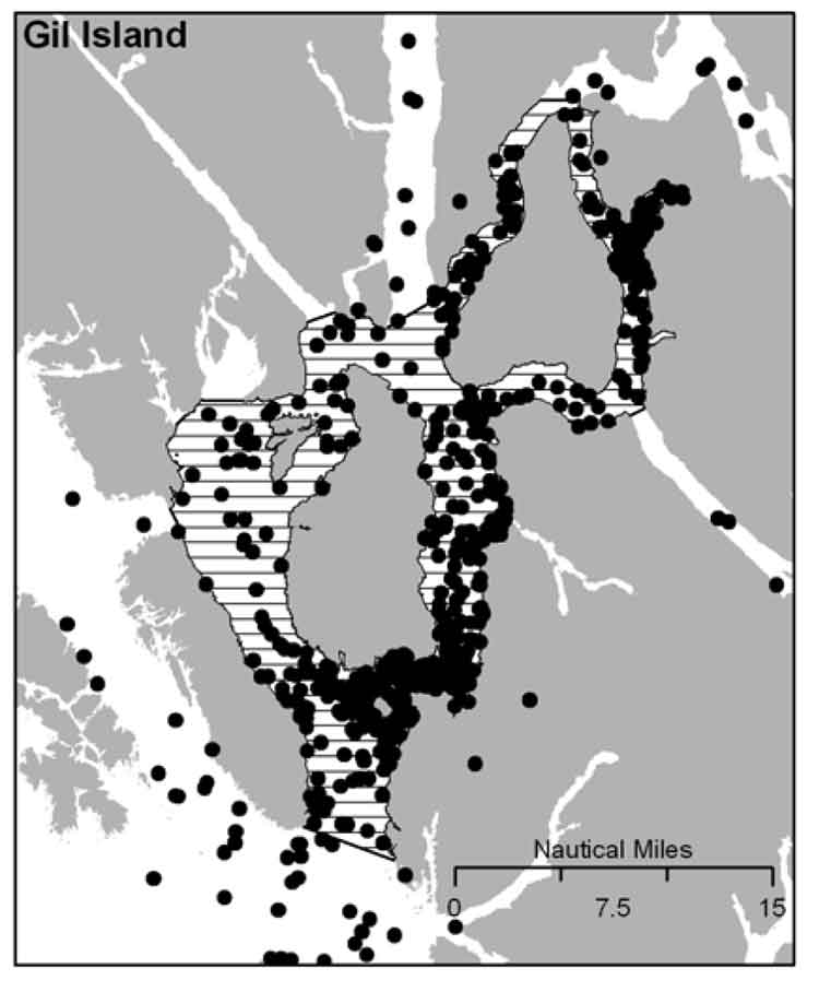
It is DFO policy to assist the humpback whale population to recover from the century of whaling that almost drove the species to extinction. The report identified four areas of “critical habitat” for humpbacks. One critical habitat zone is Gil Island at the mouth of Douglas Channel.

DFO map of humpback habitat
DFO map of humpback sightings on the BC coast. (DFO)

Last week, on November 13, Smithers based environmental activist Josette Weir filed a notice of motion with the JRP requesting that the panel consider the DFO report as late evidence.

Weir acknowledged that the JRP proceedings closed on June 24, after final arguments in Terrace, but she noted that rules allow the Board to override the final closure. She argued that the humpback report fell within the JRP’s mandate since the DFO report is “is likely to assist the Panel.”

Weir noted in her motion that there was insufficient information before the JRP that would identify critical humpback habitat.

She argued:

Three of the four critical known habitats are on the proposed tanker routes, and the Recovery Strategy acknowledges that other areas have not been identified. Without such information, it is impossible to assess the potential effects of the marine transport of bitumen on this endangered species.Activities likely to destroy or degrade critical habitat include vessel traffic, toxic spills, overfishing, seismic exploration, sonar and pile driving (i.e., activities that cause acoustic disturbance at levels that may affect foraging or communication, or result in the displacement of whales).

The report clearly identifies vessel traffic and toxic spills, which are associated with the Project as potential causes for destruction or degradation of the Humpback Whales’ critical habitat.

Weir went on to argue that the JRP had “insufficient information to develop relevant protection measures” because the humpback studies are ongoing, “meaning their results will not be available before decision.”

The Panel must consider this significant risk to an endangered listed species for which no meaningful protection measure can be offered against the risks associated with the Project.

Weir also noted that “No similar submission has been made by others, but I cannot predict if others will not see fit to do so.”

The JRP didn’t take long to reject Weir’s request, replying the next day, November 14.

In its response, the JRP cited the amended Joint Review Panel Agreement, signed after the passage of of the Jobs, Growth and Long-term Prosperity Act, the Omnibus Bill C-38, that “provides that the Panel’s recommendation report is to be submitted to the Minister of Natural Resources by 31 December 2013.”

The JRP then told Weir it didn’t have jurisdiction over endangered species (even if those species inhabit the tanker route) saying:

The Panel notes that the Recovery Strategy has been released in accordance with the provisions of the Species At Risk Act, as part of a legislative scheme that operates independently of this joint review process.

It goes on to say: “In this case, the Panel also notes that the Recovery Strategy was not authored by or for Ms. Wier.”

Map of Gil Island
Humpback whale sightings at the Gil Island critical habitat. (DFO)

The executive summary of the DFO report noted:

Critical habitat for Humpback Whales in B.C. has been identified to the extent possible, based on the best available information. At present, there is insufficient information to identify other areas of critical habitat or to provide further details on the features and attributes present within the boundaries of identified critical habitat. Activities likely to destroy or degrade critical habitat include vessel traffic, toxic spills, overfishing, seismic exploration, sonar and pile driving (i.e., activities that cause acoustic disturbance at levels that may affect foraging or
communication, or result in the displacement of whales). A schedule of studies has been included to address uncertainties and provide further details on the critical habitat feature(s), as well as identify additional areas of critical habitat. It is anticipated that results from these studies will also assist in development of relevant protection measures for the critical habitat feature(s).

In the part of the report on the danger of toxic spills to humpbacks, the DFO report mentions that sinking of the BC ferry Queen of the North:

Toxic spills have occurred impacting marine habitat along the B.C. coast. For example, the Nestucca oil spill (1988) resulted in 875 tonnes of oil spilled in Gray’s Harbor, Washington. Oil slicks from this spill drifted into Canadian waters, including Humpback Whale habitat. In 2006, a tanker ruptured in Howe Sound, B.C. spilling approximately 50 tonnes of bunker fuel into coastal waters. In 2007, a barge carrying vehicles and forestry equipment sank near the Robson Bight-Michael Bigg Ecological Reserve within the critical habitat for Northern Resident Killer Whales, spilling an estimated 200 litres of fuel. The barge and equipment (including a 10,000L
diesel tank) were recovered without incident. When the Queen of the North sank on March 22, 2006, with 225,000 L of diesel fuel, 15,000 L of light oil, 3,200 L of hydraulic fluid, and 3,200 of stern tube oil, it did so on the tanker route to Kitimat, which is currently the subject of a pipeline and port proposal and within the current boundaries of Humpback Whale critical habitat

The DFO report also takes a crtical look at vessel strikes

In B.C. waters, Humpback Whales are the most common species of cetacean struck by vessels, as reported to the Marine Mammal Response Network. Between 2001 and 2008, there were 21 reports of vessel strikes involving Humpback Whales. Of these, 15 were witnessed collision events while the remaining 6 were of live individuals documented with fresh injuries consistent with recent blunt force trauma or propeller lacerations from a vessel strike.

Overall, vessel strikes can cause injuries ranging from scarring to direct mortality of individual whales. Some stranded Humpback Whales that showed no obvious external trauma, have been shown from necropsy to have internal injuries consistent with vessel strikes… It is unknown how many whales have died as a result of vessel strikes in B.C. waters. To date, only one reported dead Humpback Whale presented with evidence consistent with blunt force trauma and lacerations resulting from a vessel strike…

There are no confirmed reports of Humpback Whale collisions in B.C. waters attributed to shipping, cruise ship or ferry traffic. However, larger ships are far less likely to detect the physical impact of a collision than smaller vessels, and this could account for the lack of reported strikes. Collisions with large vessels may be more common than reported, especially in areas where larger vessel traffic is concentrated.

Despite the fact that collisions may only affect a small proportion of the overall Humpback Whale population, vessel strikes may be a cause for concern for some local and seasonal areas of high ship traffic.. In B.C., areas of high probability of humpback-vessel interaction include Johnstone Strait off northeast Vancouver Island, Juan de Fuca Strait off southwest Vancouver Island, Dixon Entrance and the “Inside Passage” off the northern B.C. mainland which include portions of two of the identified critical habitat areas..

The JRP also said

As the Panel has mentioned previously during the hearing, the later in the joint review process that new evidence is sought to be filed the greater the likelihood of the prejudice to parties. The Panel is of the view that permitting the Recovery Strategy to be filed at this late stage in the hearing process would be prejudicial to the joint review process.

Weir’s submission to the JRP did not mention an academic study published on September 11, 2013, that also identified Gil Island as critical humpback habitat.

RELATED:

“Conservatives’ hatred for science intentional part of their environmental policy,” Cullen says

DOCUMENTS:

DFO report on Humpback Recovery strategy  (PDF)

Josette Weir notice of motion on Humpback Whales (PDF)

Panel Commission Ruling on Humpback Whales (PDF)


Special report: Clio Bay cleanup: Controversial, complicated and costly

Special report: Clio Bay cleanup: Controversial, complicated and costly

Log booming at Clio Bay
Log booming operations at Clio Bay, August 21, 2013. (Robin Rowland/Northwest Coast Energy News)

Chevron, the company operating the KM LNG project at Bish Cove and the Haisla Nation have proposed that marine clay from the Bish Cove construction site be used to cap more than 10,000 sunken and rotting logs in Clio Bay. Haisla Chief Counsellor Ellis Ross says he hopes that using clay to cover the logs will help remediate the environmentally degrading sections of the Bay. The proposal has brought heated controversy over the plan, both among residents of Kitimat and some members of the Haisla Nation, who say that Clio Bay is full of life and that the capping will cause irreparable damage.

An investigation by Northwest Coast Energy News shows that capping thousands of sunken logs is a lot more complicated and possibly costly than anyone has considered. It is also clear that many of the comments both supporting and opposing the Clio Bay project are based on guesses rather than the extensive scientific literature available on the subject.

Northwest Coast Energy News findings include:

  • In 1997, the Department of Fisheries and Oceans surveyed sunken log sites in Douglas Channel. The results, published in 2000, identified 52 sites just on Douglas Channel and the Gardner Canal that had various levels of enviromental degradation due to sunken logs. Clio Bay was not the list. The DFO scientists recomended followup studies that never happened.
  • Scientific studies show that degradation from sunken logs can vary greatly, even within one body of water, due to depth, currents, number of logs, and other factors. So one part of a bay can be vibrant and another part environmentally degraded due to low levels of dissolved oxygen and decaying organic material.
  • If  KM LNG wasn’t paying for the remediation of Clio Bay, it could be very expensive. Capping sunken logs at a cove near Ketchikan, Alaska, that is the same size and shape as Clio Bay cost the US and Alaska governments and the companies involved $2,563,506 in 2000 US dollars. The total cost of the cleanup of the site which was also contaminated with pulp mill effluent was $3,964,000. The estimated cost of capping the logs in the Alaska project was $110 per cubic yard.
  • The Alaska project shows that a remediation project means while most of the logs in a bay or cove can be capped, in some parts of a water body, depending on currents, contamination and planned future use, the logs have to be removed and the area dredged.
  • Agencies such as the State of Alaska, the US Environmental Protection Agency and the US Army Corps of Engineers all recommend using “clean sand” for capping operations. Although “clay balls” have been used for capping in some cases, the US officials contacted say they had no record of large amounts of marine clay ever being used for capping. They also noted that every log capping project they were aware of happened in sites that had other forms of contamination such as pulp mill effluent.
  • Chevron only recently retained the environmental consulting firm Stantec to study Clio Bay. The Department of Fisheries and Oceans has told District of Kitimat Council it recently completed mapping of the seafloor at Clio Bay. The Alaska project was preceded by five years of monitoring and studies before capping and cleanup began.
  • A letter from Fisheries and Oceans to the District of Kitimat says that Clio Bay has been mapped and the department is planning to monitor any capping operations. However, it appears from the Department of Fisheries and Oceans website that the department has no current policies on remediation since the Conservative government passed two omnibus which weakened the country’s environmental laws. According to the website, new remediation policies are now being drafted. That means that although DFO will be monitoring the Clio Bay operation, it is uncertain what standards DFO will be using to supervise whatever happens in Clio Bay.

Northwest Coast Energy News is continuing its investigation of the sunken logs problem.  Expect more stories in the days to come.

[rps-include post=5057]

Clio Bay: What happens to sunken logs?

Special report: Clio Bay cleanup: Controversial, complicated and costly

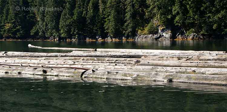
Logs at Clio Bay
Floating logs at Clio Bay, September 14, 2013. (Robin Rowland/Northwest Coast Energy News)

The forest industry has been operating on the Pacific coast from Oregon to Alaska for more than a century. Over that time, it is likely that millions of logs from booms and other operations have sunk to the bottom of bays, cove, estuaries and inlets along the coast.

During that century, scientists in both Canada and the United States have been studying the effects of the those sunken logs on the sea bottom. It is only in recent years that the cumulative effect of all those logs has become an environmental concern.

As well as logs on the sea bottom, ranging, depending on location, from a couple of hundred to the tens of thousands of logs, there are wood chips, wood fibre and discarded log parts and bark. Often metal cables, bolts, ropes, and other manufactured material either dropped accidentally or deliberately discarded are also found among the old logs, further contaminating the seabed. Compounding the problem of the sea bottom is organic material that would occur naturally on the seabed, including tree trunks, roots, branches, conifer needles, deciduous leaves and other material from terrestrial plants.

Anyone who sails Douglas Channel after a storm can see with all the floating tree trunks in the Channe. That means that storms and spring run off ads debris to the natural pile up of old logs and debris. At logging sites, this natural material, brought in by creeks and rivers, piles up on the already sunken logs.

Over the years, depending on the salinity, teredos, more popularly known as ship worms  eat the wood, often leaving a tube of bark that eventually collapses. The rotting wood, bark and other material is often, depending on conditions, pounded into fragments by the action of waves, currents and outflow from rivers. Some species of teredo can live in brackish water, but since teredos are not a fresh water species, that means that logs in fresh or mostly fresh water last longer.

A DFO report on sunken log sites on Douglas Channel, published in 2000, noted:

very few comprehensive, quantitative field studies describing the effects of wood and bark have been published and those that did focused on log handling and storage sites which handled high volumes of more than one million cubic metres.

The DFO report said that thick bark and wood debris deposits resulting from log handling can cause substantial, long-term negative impacts to benthic (sea bottom) ecosystems. Under the worst conditions, the cumulative debris can deprive an area of oxygen and, according to DFO, “virtually eliminate aerobic” sea bottom animal life.

The report noted that studies had shown that “negative biological impacts were localized,” but added that “the cumulative effect of several hundred sites located on the B.C. coast is currently unknown.”

Studying the problem has been a low priority for DFO and other agencies and that meant a limited budget and few studies. Other problems is that, according to the DFO, parts of BC fjords are steep and “much of the likely impacted habitat is beyond diver range.” There is also pressure to study the effect on “economically or socially important species.” Although the use of remotely operated vehicles has increased since the 2000 report, using an ROV can also be a budget buster for a low priority project.

As the ready timber supply in British Columbia particularly old growth forest declined in the last part of the twentieth century, the DFO report says “forest companies have harvested areas where access is more difficult and cut-blocks are smaller.” That meant many smaller dump sites were developed that were used for only one to five years. Plans for log handling at the time, DFO said, were evolving to ensure ensure that fisheries resources and overall fish production capability were not adversely affected by development of log handling facilities and planning was focused on ensuring that sites for log handling facilities did “not have sensitive fish habitats or fisheries resources (such as eel grass beds or shellfish resources) which may be affected by the log handling,”

One of the reasons for the disagreements over Clio Bay is that while some people call it “dead” saying there are no halibut and fewer cod, others say that Clio Bay is very much alive, pointing out that it is easy to catch crab and rock cod.

The studies that have looked at life on the bottom of log dumps sites have shown that it can be highly variable even within one bay or cove, with many factors creating small local ecosystems, including depth, nature of the sea bottom, for example sand, mud, clay or a mixture, whether or not the sea bottom sediment is “enriched,” the flow of currents, fresh water flow into the site, the percentage of wood on the bottom, the percentage of bark on the bottom, whether the wood and/or bark debris is “continuous’ or “discontinuous,” whether or not the seabed is contaminated as was the case with the cleanup of pulp mill sites at Ward Cove and Sitka, Alaska.

Ward Cove had been so polluted for decades by pulp mill effluent that it was eligible for US Superfund clean up funding and was estimated to hold 16,000 sunken logs. At the same time, an EPA report on Ward Cove noted that at the point Ward Creek emptied into Ward Cove was “a popular sport fishing location during salmon season, including commercially guided fishing. Some sport fishing and personal-use crab pot fishing has taken place in the past and may continue in the waters of the cove.” At the same time of the cleanup, the EPA identified that the degradation of Ward Cove put at risk eight species of salmon, 75 “non-salmonid esturine and marine fish species and benthic invertebrate fauna.”  (The EPA says Ward Cove is recovering after the reclamation and fishing is continuing)

In other words, those say Clio Bay is in danger and those who say Clio Bay is a rich source of life are likely both right.

For example, while Chris Picard’s (then with the University of Victoria, now with the Gitga’at First Nation) study of Clio Bay said: “Dungeness crabs were observed five times more often in the unimpacted Eagle Bay than in Clio Bay,” and tied that to log dumping and low oxygen.
Picard’s study noted that both Dungeness crabs and sunflower seastars, while more abundant in Eagle Bay, in Clio Bay “both species were several-fold less abundant in wood-dominated habitats in Clio Bay than in non-wood habitats in that bay.”

Several people have pointed out that since Clio Bay is one of the closest crabbing spots to both Kitimat and Kitamaat Village, while Eagle Bay is further down Douglas Channel, overfishing at Clio may be a factor in the reported species decline.

The DFO study noted

The dumping of logs into water down skids can result in the generation of a considerable amount of bark and wood debris. The abrasive action of boom boats and waves during the sorting and storage of bundles can also generate quantities of wood debris. Bark and wood lost during dumping often forms thick, continuous, anoxic fibre mats extended from the base of the dump skids. The debris mat tends to dissipate with distance from the entry point; however, wood debris can often be observed substantial.” distances from the dump skids as seen at all four of the sites sampled. Debris deposits can also be generated as logs resting on the sea floor decay. Wood boring organisms (e.g., Toredo) quickly reduce the wood fibre content of logs, but the bark of some species (e.g., western red cedar (Thuja plicata) which has a high lignin content) is left relatively untouched. The amount of wood debris generated during handling and storage can be different depending on tree species, tidal levels, and dumping methods. Debris accumulation, distribution, and the resulting biological impacts are affected by physical factors including depth, sea floor slope, dump site aspect, water currents, and wind or wave exposure.

One of the main problems with log dumping is that it has the potential to deplete vital oxygen, especially at deeper levels. Seasonal variations can mean that, even if there are thousands of logs at the bottom, the levels of dissolved oxygen can vary. Years of studies at the cleanup site at Ward Cove, Alaska showed how the oxygen levels can vary by season. In Minette Bay, near Kitimat, a DFO study showed that the Minette is somewhat stagnant and therefore has naturally occurring low oxygen levels, but also that the low levels usually last from May to November and are worst in July.

The DFO study went on to say that oxygen poor thick anoxic bark or wood fibre deposits are likely to cause damage to bottom dwelling species, although in the short term, logs may not cause any impacts. It says that some studies have indicated that large pieces of wood debris can, for a time, increase diversity by providing suitable base for some filter feeders as well as food and cover for epifauna and wood boring organisms. Several species not normally found in sand-bed have occasionally been found in log and rock debris.

(Studies have shown that salmon the ability to detect low oxygen areas and avoid them and some active  invertebrate species can migrate away from a low oxygen area.)

In the long term, logs do decay and the wood and bark left behind can contribute to the wood debris accumulation. One study cited by the DFO survey of Douglas Channel found found that crabs avoided bark deposits when given a choice but when they were forced to live among bark deposits, they were had fewer offspring, had lower feeding rates, and had a decreased survivorship.

One theory is that the decaying organic material produces hydrogen sulphide in combination with ammonia and other unmeasured toxicants. One study of Dungeness crabs, living at a log dump in southeast Alaska with elevated hydrogen sulphide and ammonia concentrations in the bark debris, shows the colony had less than half as many reproducing females as a control population.

The EPA and Alaska reports from Ward Cove show that sand capping does help restore the seabed environment.
[rps-include post=5057]

Clio Bay: Links and Documents

Links and documents relating to sunken logs and site remediation

Note many, not all, external links are to pdf files.

Canada

DFO study of sunken log sites in Douglas Channel

DFO Study Dissolved oxygen cycle in Minette Bay

Impact of Wood debris in British Columbia estuaries

Chris Picard’s study of Clio and Eagle Bays as posted on the University of Laval website

United States

Links

Alaska Department of Environmental Conservation

Environmental Protection Agency

Ketchikan Paper Company
This is the EPA Web site on the Ward Cove cleanup and remediation with numerous documents.

EPA capping guidance
EPA contaminated sediment capping guidance

US Army Corps of Engineers

US Army Corps of Engineers capping guidance

Documents

Alaska log site remediation guide  (pdf)

EPA study of dissolved oxygen in Ward Cove (pdf)

Marine Log Transfer Facilities and Wood Waste (pdf)

Academic paper by Ward Cove consultants Geramano & Associates on sediments in Ward Cove and Thorne  Bay, Alaska.

Ward Cove Sediment Remediation Project Revisited

Academic paper by Ward Cove consultants Integral Consulting


 Other Links

Kitimat LNG (KM LNG)

Stantec

Stantec remediation project page

Integral Consulting

Integral Consulting Ward Cove web page

Exponent 

Exponent Ward Cove web page

Exponent LNG Safety web page

Germano & Associates

(Note not all documents used in this report are available online. Some sent to NWCEN are too large to upload)


[rps-include post=5057]

Gil Island “critical habitat” as humpbacks double at the mouth of Douglas Channel. New study says tanker traffic could threaten key spots

Humpback whale at Bish Cove
A humpback whale, seen here by its small dorsal fin, swims past the Chevron Apache KM LNG site at Bish Cove on Douglas Channel, August 21, 2013. (Robin Rowland/Northwest Coast Energy News)


Updated with comments from Gitga’at First Nation, Nathan Cullen and Shell Canada.

Gil Island is a “critical habitat” for the world’s humpback whales, whose numbers are increasing in Douglas Channel, Wright Sound, Estevan Sound and Camano Sound and nearby waters, according to a study released Wednesday, September 11, 2013. The study also goes on to warn that potential tanker traffic through the “geographic bottleneck” on Douglas Channel to and from Kitimat could threaten that crucial “pit stop” for the humpback whales.

The study, “Abundance and Survival of Pacific Humpback Whales in a Proposed Critical Habitat Area,” by Erin Ashe, of the University of St. Andrews, in Scotland, Janie Wray of Oceans Initiative on Pearse Island, Christopher Picard of the North Coast Caetacian Society in Hartley Bay and Rob Williams of the Gitga’at Nation Lands and Marine Resources Deptartment, is published in the jourrnal PLOS One.

The research team estimated the abundance of Pacific humpback whales by using photo-identification surveillance of adult humpbacks. They found that the number of humpback whales in this region increased each year, and doubled from 2004 to 2011, resulting in a total of 137 identifiable whales in 2011. The survey was conducted year-round. Abundance was estimated only during the summer months of July to September, when the migrating whale population is largest.

The survey focused on summer feeding regions in the northwestern BC coastal fjords that serve as a “pit stop” for whales between migrations. Migrating whales travel to the BC coast from calving grounds as far away as Mexico, Hawaii or Japan. After several months without feeding, the humpbacks arrive in BC, and, the study says, show “strong site fidelity to local feeding grounds” around the entrance to Douglas Channel.

The authors estimated that “survivorship,” the average probability of an adult whale surviving from one year to the next on the northwest coast of British Columbia is among the highest reported anywhere for the species. During “this critical refueling stage in these waters, the whales are more vulnerable to environmental stressors, such as those potentially created by increasing tourism and industrial development in the region.”

The study also says that study area has also been identified as candidate critical habitat for northern resident killer whales and notes the region “has been recolonized by fin whales in recent years.” (With details on the fin whales to come in future studies)

The study estimates there were once about 15,000 humpback whales in the North Pacific when whalers began hunting the animals. That number was down to 1,400 when whale hunting was stopped in Canada in 1966. “It is therefore good news that the segment of the population using our study area is growing and adult survival is near the limit that one would expect for this species. That said, although the population is recovering, there is no evidence that it has yet fully recovered to pre-exploitation levels in BC and we do not wish to become complacent.” the study says.

It goes on to say:

Humpback whales may be facing increasing threats in at least one of their proposed critical habitats in BC. Numerous port facility expansions and new terminal proposals, including numerous crude oil and liquefied natural gas (LNG) export proposals, could substantially increase deep-sea shipping traffic through BC’s north and central coast waters. Such developments could exacerbate oil spill, acoustic disturbance, and ship strike risks to humpbacks. In particular, the Gil Island proposed critical habitat area where our work was conducted, spatially corresponds with all shipping routes leading to Kitimat, BC port facilities that are currently being considered by regulatory agencies for high-volume crude oil and LNG tanker traffic and other increased shipping activities.

The monitoring program showed that “a relatively large fraction of BC’s humpback whales rely on the waters around Gil Island, given the small size of the study area.”


Humpback whale in Douglas Channel
The tail fins of a humpback whale are seen in Douglas Channel near Bish Cove, as a fishing boat speeds toward Kitimat harbour in a rain storm on Aug. 21, 2013. (Robin Rowland/Northwest Coast Energy News)

The study warns:

This high reliance on relatively small fractions of available habitat has important implications for conservation and management. It lends support to the proposal to designate the current study area as part of the population’s critical habitat…

This also suggests that area-based management for cetaceans can effectively target small areas if these areas are chosen carefully. The corollary to this, though, is that a tendency for animals to be concentrated or aggregated in small areas lends them vulnerable to catastrophic events like oil spills and ship strikes. Critical habitats like the Gil Island waters are therefore a mixed blessing when high densities of whales are found in geographic bottlenecks that also funnel and concentrate shipping traffic. Anthropogenic threats to this must be evaluated not only in terms of the proportion of available habitat that this area represents, but also in terms of its critical importance to large numbers of whales for critical life-history processes. The risk and ecological consequences of an oil spill in this region would increase substantially if proposals were approved to ship large volumes of oil and LNG traffic through the Gil Island waters. Studies in Pacific waters similar to our study area suggest that oil spills can have severe and chronic impacts to cetacean populations and it is uncertain whether affected populations can recover from such perturbations.

One reason for the study is that while the humpback is considered an endangered species in the United States, in Canada it is listed as “threatened” under Canada’s Species at Risk Act and the increasing numbers could mean that the humpback is downgraded to “special concern.”

The study was based on what is called “community based science,” a cost-effective partnership between scientists, the Gitga’at Nation and other First Nations, NGOs and the Department of Fisheries and Oceans.

As part of its Pacific humpback whale recovery strategy, DFO has proposed four areas as candidate critical habitat. One criterion for designating critical habitats within northern BC coast feeding grounds is that inlets are used for specialized ‘‘bubble-net’’ feeding behaviour (where the humpbacks create a fishing net of bubbles to catch their prey).

Map of study areaAt the start of the study, the team had noted that “mainland inlets have been somewhat under-represented in habitat studies” and so they began working on the photo-identification of the humpbacks, using two research groups, the North Coast Cetacean Society and the Gitga’at Lands and Marine Resources Department. Surveys were conducted as weather permitted throughout the year from April to November (with occasional trips in February, March and December), from 2004 to 2011.

The aim of the study was to “collect as many high-quality photographs of individually recognizable humpback whales as possible within the study area [referred to in the study  as ‘Gil Island waters’’] from Estevan Sound in the west to Ursula Channel in the east. One 27 foot and one 18 foot boat were used to conduct the surveys. A total of 374 photo- identification surveys conducted over 47 months resulted in a catalogue of 177 high-quality, unique identifications of individual humpback whales.

Information also came from “an informal sightings network including local fishermen and tourism operators who reported humpback and killer whale sightings over VHF radio;” hydrophones monitored for vocalizing humpback whales; and visual monitoring from the land-based Cetacealab facility on the south end of Gil Island.

When a humpback was sighted, they were identified by the fingerprint like tail flukes and the numbers cataloged.

The study was funded by grants to Cetacealab and Gitga’at First Nation from Julie Walters and Sam Rose, and from Fisheries and Oceans Canada (Cetacean Research Program, Species at Risk Program). There was also support from King Pacific Lodge.

Updates


In a news release, the Gitga’at First Nation said:

“The importance of our territorial waters for humpback and other species of whales, should give pause to those who would propose tanker routes through the Douglas Channel,” said Arnold Clifton, Chief Councillor of the Gitga’at First Nation. “The increase in whales in our territory coincides with low shipping traffic, however current proposals would increase shipping traffic to unprecedented levels. We remain resolute in our determination to protect whales and the natural heritage of our territory from tankers and other developments that would put them at risk.”
“Our study shows that while still vulnerable, humpback whales are recovering, and this area plays an important role in supporting their numbers,” said lead author, Erin Ashe, a PhD candidate at the University of St. Andrews and a co-founder of Oceans Initiative. “Identifying and protecting critical habitat is one of the most effective ways to support endangered species recovery.”
The waters around Gil Island are especially rich habitat for humpback whales, due to high abundance of their preferred foods, such as krill and herring and due to the remote nature of the coastal fjords. Humpbacks, which rely on acoustic communication, are sensitive to noise pollution from ship traffic.
“It is Cetacea Lab’s contention that all levels of government must collaborate with the Gitga’at First Nation and others in protecting humpback whales from the risk of increased tanker traffic,” said Janie Wray, whale researcher with Cetacea Lab. “This study represents the best available scientific information about the importance of this area to humpback whales. Over the course of our study, we have observed the population more than double, with mothers returning year after year with their calves, introducing the next generation of juvenile whales to the nutrient-rich feeding grounds of Douglas Channel to Caamano Sound.”


In his biweekly conference call with Northwest BC reporters, Skeena Bulkley Valley MP Nathan Cullen said: “I don’t get a sense from the way that the federal government has designed this [referring to Enbridge Northern Gateway] project, that on the marine side, any of these things are important to Mr. Harper. When you start to place down the most important values and certainly for British Columbians and Canadians, protecting a humpback feeding ground would seem like an important value in the Great Bear Rainforest, you start to see where the limits and the restrictions are on any idea of moving oil super tankers through such a narrow place. It’s just another bit of evidence, a bit of science that says this is difficult, if not impossible, and Enbridge’s project has made so many of those arguments more and more clear as we start to bring science to the table.

“It’s so frustrating for people that evidence, our opinions and our values just don’t seem to matter to the federal government. They already said yes to this thing years ago and damn the science, damn anything that comes their way. That’s not going to work, not going to work for us and not going to work for the humpback whales.”

A spokesperson for Shell’s LNG Canada project, noting that the company officials had not yet read the study, said, “It’s early days for the proposed project and the start of a thorough regulatory process. We welcome contributions and thoughts on important matters. We will look at this study. As with any project in Canada we work with local First Nations and local communities to minimize the impact of our activities.”

Neither Enbridge Northern Gateway nor Apache, a partner in the KM LNG project, responded to a request for comment.

Transport Canada promises consultation on Kitimat port five days after announcement it will become public

Five days after the announcement that the private port of Kitimat will become a public port under federal jurisdiction,  Transport Canada is now promising to consult District of Kitimat officials as the Douglas Channel waterfront transitions to a public port.

Both Kitimat Mayor Joanne Monaghan and Economic Development Officer Rose Klukas, after numerous calls and attempts over the past few days, finally spoke to different Transport Canada officials Friday.

According to the mayor, both were told that Kitimat will not become a public port for at least one year because the change from a private port to a public port requires a change in legislation. (Something Transport Canada may only just be realizing since Bill C-57, introduced Monday to cover all the changes for what the Harper government calls a “world-class” tanker policy makes no mention of Kitimat).

Transport Canada is now promising “extensive public and stakeholder consultation will occur before the legislation is changed,” the mayor was told.

On this Mayor Monaghan commented, “It seems to me that now they want to do consultation….sort of like closing the barn door after all of the cows got out!”

Transport Canada says that beause there are no federal lands in the Kitimat harbour, the amending legislation will only cover navigable waters in Kitimat.

Transport Canada will appoint a harbour master and the cost of that office will be “paid by offsetting fees charged to ships coming into the harbour.”

But it looks like the fees charged to incoming ships by the federal government could be causing a headache for Rio Tinto Alcan.  Claudine Gagnon, an RTA spokesperson based in Shawnigan, Quebec, told Radio Canada, the French language network of the CBC, that the company is trying to assess the impact of the announcement on its operations in Kitimat. Among other things, the change in the port’s status could result in higher transportation costs for the company.

Ottawa surprend Kitimat avec l’annonce de la nationalisation de son port

Google translate of Radio Canada story.

At this point, Transport Canada officials told the District is unlikely that there will be Port Authority in Kitimat like the one in Prince Rupert.

Cullen surprised

Asked about the port announcement during a post budget news conference on Thursday, Skeena Bulkley Valley MP and NDP House Leader Nathan Cullen said, “I’m as surprised as everybody in Kitimat is. I’ve been phoning around to local leaders to find out if anyone had been consulted or spoken to about this. And it’s a shock for everyone including people from Alcan.

“This doesn’t make any sense at all. The conversation around a public port is a good one and one we need to have and we’re open to the idea, but what a terrible start to the process, when a minister flies in from Ottawa, announces something, doesn’t tell any of the local government about it and then expects everyone to pop the champagne corks. You want to get this thing right. You want to make sure the public interests are met.

“There’s a real arrogant feeling, when a minister flies in from Toronto and says this is how it’s going to be and there’s no need to talk to anyone in the region about it.

Related
Mayor Joanne Monaghan interviewed by Andrew Kurjata on CBC Daybreak North (Friday morning before Transport Canada returned calls to Kitimat)

Cullen was also asked about the provisions in the safe tankers announcement on Monday by Transport Minister Denis Lebel and Natural Resources Minister Joe Oliver that the federal government appears to be taking over responsibility for navigation aids on the British Columbia coast, something that until now, Enbridge Northern Gateway has said they will pay for.

“Suddenly taking costs away from a multi-billion dollar oil company, seems to be what this Conservative Canadian government wants to do. It’s so wrong, I can’t describe it any better than that,”Cullen said, “that we’re supposed to be picking up the tab for Enbridge’s project, while all the while running huge deficits and not getting the training support and cuts to health care programs that continue.”

Previous stories

Kitimat port announcement surprise to Rio Tinto Alcan, District of Kitimat

Oliver confirms Kitimat to become a public port

Harper government outlines new tanker safety measures for west coast

How “On the Waterfront” could decide the fate of Enbridge’s Kitimat terminal

Water, not oil, is the hot issue this summer in Kitimat

Rio Tinto Alcan reopens access to Kitimat waterfront