Clio Bay: Haisla desire to clean up bay led to proposal to cap Clio with marine clay, Ross says

Special report: Clio Bay cleanup: Controversial, complicated and costly

Clio Bay
Clio Bay, looking toward Douglas Channel, September 14, 2013. (Robin Rowland/Northwest Coast Energy News)


Haisla First Nation Chief Counsellor Ellis Ross says the Haisla made the proposal to the KM LNG project, a partnership of Chevron and Apache, to use the marine clay to cover the thousands of logs at the bottom of Clio Bay after years frustration with the Department of Fisheries and Oceans and the BC provincial government, which for decades ignored requests for help in restoring almost fifty sunken log sites in Haisla traditional territory.

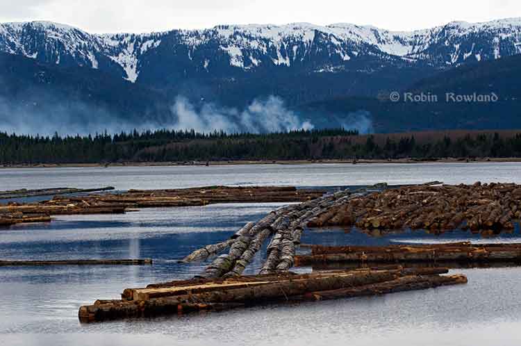
The problem is that remediation of the hundreds of sites on Canada’s  west coast most containing tens of thousands of sunken logs has been so low on DFO’s priority list that even before the omnibus bills that gutted environmental protection in Canada, remediation of sunken log sites by DFO could be called no priority.

Now that the KM LNG has to depose of a total of about 3.5 million cubic metres of marine clay and possibly other materials from the Bish Cove site, suddenly log remediation went to high priority at DFO.

The controversy is rooted in the fact that although the leaders of the Haisla and the executives at Chevron knew about the idea of capping Clio Bay, people in the region, both many residents of Kitimat and some members of the Haisla were surprised when the project was announced in the latest KM LNG newsletter distributed to homes in the valley.

Chevron statement

In a statement sent to Northwest Coast Energy News Chevron spokesperson Gillian Robinson Ridell said:

The Clio Bay Restoration Project  proposed by Chevron, is planned to get underway sometime in early 2014. The proposal is fully supported by the Federal Department of Fisheries and Oceans and the Haisla First Nation Council.  The project has been put forward as the best option for removal of the marine clay that is being excavated from the Kitimat LNG site at Bish Cove. Chevron hired Stantec, an independent engineering and environmental consulting firm with extensive experience in many major habitat restoration projects that involve public safety and environmental conservation.  The Haisla, along with Stantec’s local marine biologists, identified Clio Bay as a site that has undergone significant environmental degradation over years of accumulation of underwater  wood debris caused by historic log-booming operations. The proposal put forward by the marine biologists was that restoration of the marine ecosystem in the Bay could be achieved  if marine clay from Chevron’s facility site, was used to cover the woody debris at the bottom of the Bay. The process outlined by the project proposal is designed to restore the Clio Bay seafloor to its original soft substrate that could sustain a recovery of biological diversity.

Kitimat worried

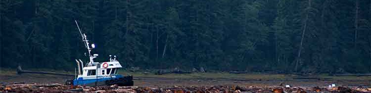
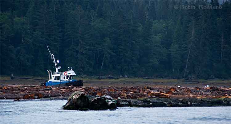
Non-aboriginal residents of Kitimat are increasingly worried about being cut off from both Douglas Channel and the terrestrial back country by industrial development. These fears have been heightened by reports that say that Clio Bay could be closed to the public for “safety reasons” for as much as 16 months during the restoration project.

The fact that Clio is known both as a safe anchorage during bad weather and an easy to get to location for day trips from Kitimat has made those worries even more critical.

There is also a strong feeling in Kitimat that the residents were kept out of the loop when it came to the Clio Bay proposal.

In a letter to the District of Kitimat, DFO said:

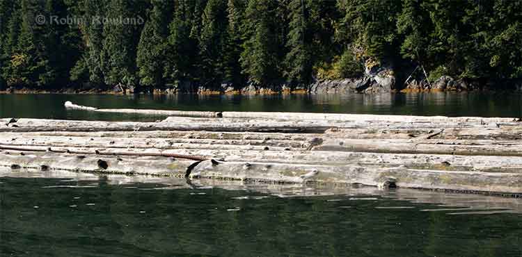
Clio Bay has been used as a log handling site for decades which has resulted in areas of degraded habitat from accumulations of woody debris materials on the sea floor. The project intends to cap impacted areas with inert materials and restore soft substrate seafloor. The remediation of the seafloor is predicted to enhance natural biodiversity and improve the productivity of the local fishery for Dungeness crab. The project area does support a variety of life that will be impact and therefore the project will require authorization from Fisheries and Oceans Canada for the Harmful Alteration, Disruption or Destruction (HADD) of fish and fish habitat.

The letter avoids the controversy over the use of marine clay but saying “inert material” will be used. That can only increase the worries from residents who say that not only clay but sand, gravel and other overburden from Bish Cove and the upgrade of the Forest Service Road may be used in Clio Bay. (The use of “inert material” also gives DFO an out if it turns out the department concludes the usual practice of using sand is better. That, of course, leaves the question of what to do with the clay).

Although Ellis Ross has said he wants to see large numbers of halibut and cod return to Clio Bay, the DFO letter only mentions the Dungeness Crab.

DFO website cites pending changes after the passage of the omnibus bills.

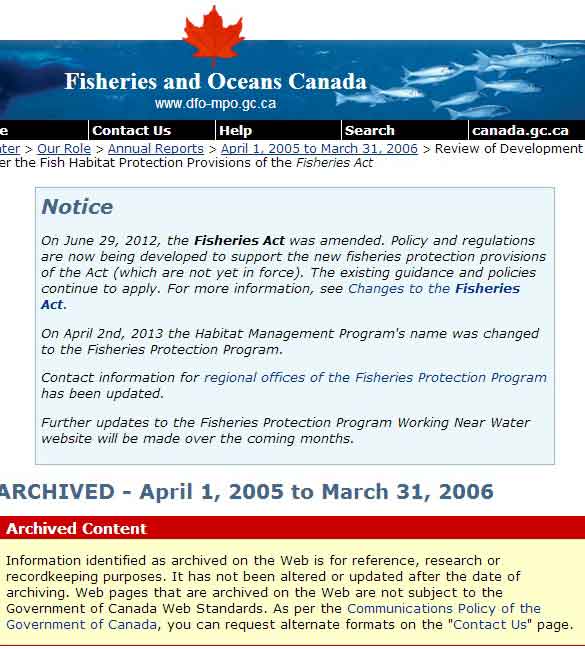
Try to search “remediation” on the DFO site and the viewer is redirected to a page that cites the omnibus bills passed by the Conservative government and says

On June 29, 2012, the Fisheries Act was amended. Policy and regulations are now being developed to support the new fisheries protection provisions of the Act (which are not yet in force). The existing guidance and policies continue to apply. For more information, see Changes to the Fisheries Act.

On April 2nd, 2013 the Habitat Management Program’s name was changed to the Fisheries Protection Program.

So, despite what communications officers for DFO and the Harper government may say, there was no policy then and there is no policy now on remediation of log sites. Given Harper’s attitude that LNG and possibly bitumen export must proceed quickly with no environmental barriers, it is likely that environmental remediation will continue to be no priority—unless remediation becomes a problem that the energy giants have to solve and pay for.

Alaska studies

On the other hand, the State of Alaska and the United States Environmental Protection Agency spent a decade at a site near Ketchikan studying the environmental problems related to sunken logs at transfer sites

Those studies led Alaska to issue guidelines in 2002 with recommended practices for rehabilitating ocean log dump sites and for the studies that should precede any remediation project.

The Alaska studies also show that in Pacific northwest coast areas, the ecological effects of decades of log dumping, either accidental or deliberate, vary greatly depending on the topography of the region, the topography of the seabed, flow of rivers and currents as well as industrial uses along the shoreline.

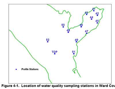
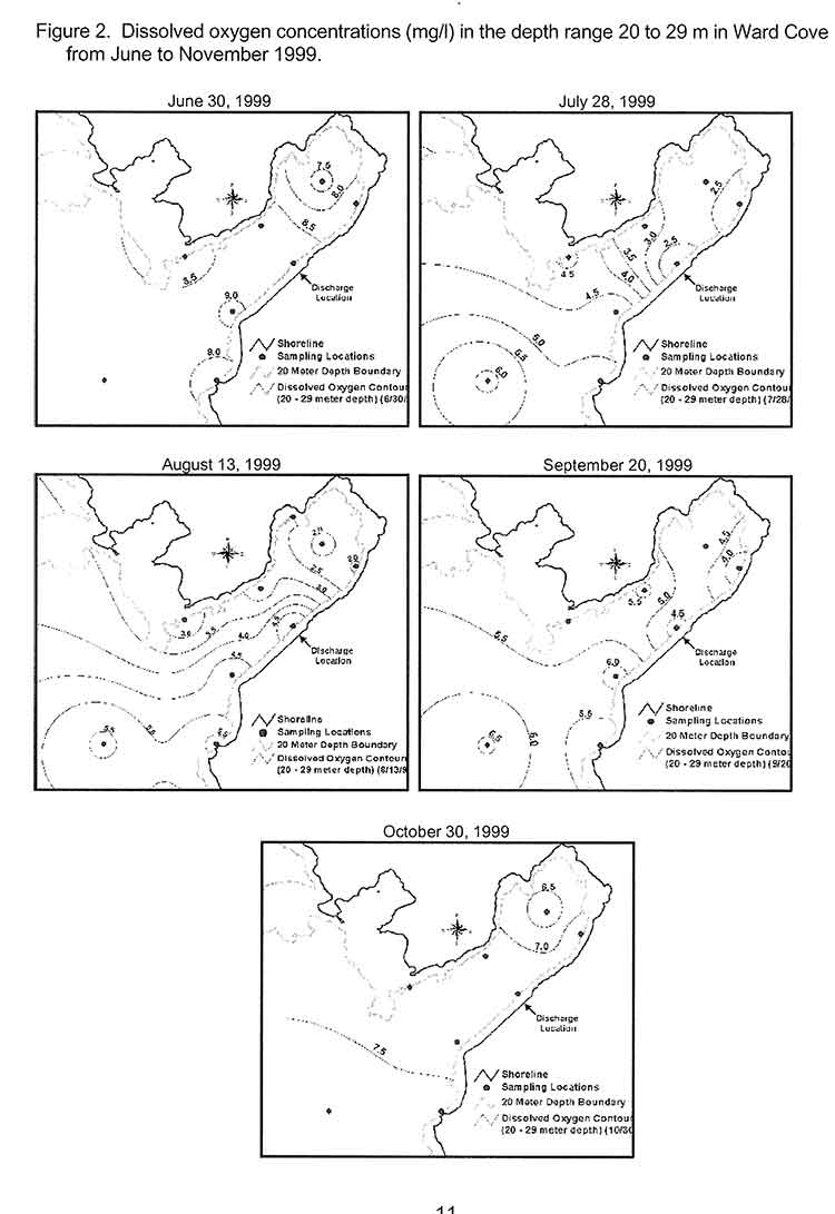
The Alaska policy is based on studies and a remediation project at Ward Cove, which in many ways resembles Clio Bay, not far from Kitimat, near Ketchikan.

The Alaska policy follows guidelines from both the US Environmental Protection Agency and the US Army Corps of Engineers that recommend using thin layers of “clean sand” as the best practice method for capping contaminated sites. (The Army Corps of Engineers guidelines say that “clay balls” can be used to cap contaminated sites under some conditions. Both a spokesperson for the Corps of Engineers and officials at the Alaska Department of Environmental Conservation told Northwest Coast Energy News that they have no records or research on using marine clay on a large scale to cap a site.)

The EPA actually chose Sechelt, BC, based Construction Aggregates to provide the fine sand for the Ward Cove remediation project. The sand was loaded onto 10,000 tonne deck barges, hauled up the coast to Ward Cove, offloaded and stockpiled then transferred to derrick barges and carefully deposited on the sea bottom using modified clam shell buckets.

The EPA says

Nearly 25,000 tons of sand were placed at the Ward Cove site to cap about 27 acres of contaminated sediments and 3 other acres. In addition, about 3 acres of contaminated sediments were dredged in front of the main dock facility and 1 acre was dredged near the northeast corner of the cove. An additional 50 acres of contaminated sediments have been left to recover naturally.

A report by Integral Consulting, one of the firms involved at the project estimated that 17,800 cubic metres of sand were used at Ward Cove.

In contrast, to 17,800 cubic metres of sand used at Ward Cove, the Bish Cove project must dispose of about 1.2 million cubic metres of marine clay at sea (with another 1.2 million cubic metres slated for deposit in old quarries near Bees Creek).

Studies at Ward Cove began as far back as 1975. In 1990 Alaska placed Ward Cove on a list of “water-quality limited sites.” The studies intensified in 1995 after the main polluter of Ward Cove, the Ketchikan Paper Company, agreed in a consent degree on a remediation plan with the Environmental Protection Agency in 1995. After almost five years of intensive studies of the cove, the sand-capping and other remediation operations were conducted from November 2000 to March 2001. A major post-remediation study was carried out at Ward Cove in 2004 and again in 2009. The next one is slated for 2015.

Deaf ears at DFO

“We need to put pressure on the province or Canada to cleanup these sites. We’ve been trying to do this for the last 30 years. We got nowhere,” Ellis Ross says. “Before when we talked [to DFO] about getting those logs and cables cleaned up, it fell on deaf ears. They had no policy and no authority to hold these companies accountable. So we’re stuck, we’re stuck between a rock and hard place. How do we fix it?”

Ross says there has been one small pilot project using marine clay for capping which the Haisla’s advisers and Chevron believe can be scaled up for Clio Bay.

Douglas Channel studies

The one area around Kitimat that has been studied on a regular basis is Minette Bay. The first study occurred in 1951, before Alcan built the smelter and was used as a benchmark in future studies. In 1995 and 1996, DFO studied Minette Bay and came to the conclusion that because the water there was so stagnant, log dumping there had not contributed to low levels of dissolved oxygen although it said that it could not rule out “other deleterious effects on water quality and  habitat`from log dumping.”

That DFO report also says that there were complaints about log dumping at Minette Bay as far back as 1975, which would tend to confirm what Ross says, that the Haisla have been complaining about environmentally degrading practices for about 30 years.

Ross told Northwest Coast Energy News that if the Clio Bay remediation project is successful, the next place for remediation should be Minette Bay.

A year after the Minette Bay study, DFO did a preliminary study of log transfer sites in Douglas Channel, with an aerial survey in March 1997 and on water studies in 1998. The DFO survey identified 52 locations with sunken logs on Douglas Channel as “potential study sites.” That list does not include Clio Bay. On water studies were done at the Dala River dump site at the head of the inlet on Kildala Arm, Weewanie Hotsprings, at the southwest corner of the cove, the Ochwe Bay log dump where the Paril River estuary opens into the Gardner Canal and the Collins Bay log dump also on the Gardner Canal.

In the introduction to its report, published in 2000, the DFO authors noted “the cumulative effect of several hundred sites located on BC coast is currently unknown.”

DFO list of sunken log sites on Douglas Channel   (pdf)

Since there appears to have been no significant follow-up, that cumulative effect is still “unknown.”

In 2000 and 2001, Chris Picard, then with the University of Victoria, now Science Director for the Gitga’at First Nation did a comparison survey of Clio Bay and Eagle Bay under special funding for a “Coasts Under Stress” project funded by the federal government. Picard’s study found that Eagle Bay, where there had been no log dumping was in much better shape than Clio Bay. For example, Picard’s study says that “Dungeness crabs were observed five times more often in the unimpacted Clio Bay.”

Although low oxygen levels have been cited as a reason for capping Clio Bay, Picard’s study says that “near surface” oxygen levels “did not reliably distinguish Clio and Eagle Bay sediments.” While Clio Bay did show consistent low oxygen levels, Eagle Bay showed “considerable interseasonal variation” which is consistent with the much more intensive and ongoing studies of oxygen levels at Wards Cove.

Chevron’s surprise

It appears that Chevron was taken by surprise by the controversy over the Clio Bay restoration. Multiple sources at the District of the Kitimat have told Northwest Coast Energy News that in meetings with Chevron, the company officials seemed to be scrambling to find out more about Clio Bay.

This is borne out by the fact, in its communications with Northwest Coast Energy News, Chevron says its consulting firm, Stantec has cited just two studies, Chris Picard’s survey of Clio Bay and a 1991 overview of log-booming practices on the US and Canadian Pacfic coasts. So far, Chevron has not cited the more up-to-date and detailed studies of Ward Cove that were conducted from 1995 to 2005.

Chevron says that Stantec marine biologists are now conducting extensive field work using divers and Remote Operated Vehicle surveys to “observe and record all flora and fauna in the bay and its levels of abundance. Stantec’s observations echoed the previous studies which determined that the massive amount of wood has harmed Clio Bay’s habitat and ecosystem.”

In its statement to Northwest Coast Energy News, Chevron cited its work on Barrow Island,  in Western Australia, where the Chevron Gordon LNG project is on the same island as a highly sensitive ecological reserve. Chevron says the Australian site was chosen only after a thorough assessment of the viability of other potential locations, and after the implementation of extensive mitigation measures, including a vigorous quarantine program for all equipment and materials brought on to the Barrow island site to prevent the introduction of potentially harmful alien species.

Reports in the Australian media seem to bare out Chevron’s position on environmental responsibility. Things seem to be working at Barrow Island.

Robinson went on to say:

Those same high environmental standards are being applied to the Kitimat LNG project and the proposed Clio Bay Restoration project. The proposed work would be carried out with a stringent DFO approved  operational plan in place and would be overseen by qualified environmental specialists on-site.

The question that everyone in the Kitimat region must now ask is just how qualified are the environmental specialists hired by Chevron and given staff and budget cuts and pressure from the Prime Minister’s Office to downgrade environmental monitoring just how stringent will DFO be monitoring the Clio Bay remediation?

Alaska standardsIn the absence of comprehensive Canadian studies, the only benchmark available is that set by Alaska which calls for:Capping material, typically a clean sand, or silty to gravelly sand, is placed on top of problem sediments. The type of capping material that is appropriate is usually determined during the design phase of the project after a remediation technology has been selected. Capping material is usually brought to the site by barge and put in place using a variety of methods, depending on the selected remedial action alternative.

Thick Capping

Thick capping usually requires the placement of 18 to 36 inches of sand over the area. The goal of thick capping is to isolate the bark and wood debris and recreate benthic habitat that diverse benthic infauna would inhabit.

Thin Capping

Thin capping requires the placement of approximately 6 – 12 inches of sand on the project area. It is intended to enhance the bottom environment by creating new mini-environments, not necessarily to isolate the bark and wood debris. With thin capping, surface coverage is expected to vary spatially, providing variable areas of capped surface and amended surface sediment (where mixing between capping material and problem sediment occurs) as well as limited areas where no cap is evident.

Mounding

Mounding places small piles of sand or gravel dispersed over the waste material to create habitat that can be colonized by organisms. Mounding can be used where the substrate will not support capping.

[rps-include post=5057]

Clio Bay: Dead or alive?

Special report: Clio Bay cleanup: Controversial, complicated and costly

Log booming at Clio Bay
Log booming operations at Clio Bay, August 21, 2013 (Robin Rowland/Northwest Coast Energy News)

Updated October 3, 2013, with DFO statement

One of the major concerns about Clio Bay is the possible lack of oxygen to support sealife. While some people have called Clio Bay “dead,” others have pointed to catches of crab, cod and salmon to dispute that.

The experience at Ward Cove, Alaska, even though it was more polluted than Clio Bay, shows that oxygen levels are highly variable, depending on season, location and depth.

In 1995, the DFO`s Institute of Ocean Siences studied dissolved oxygen levels in Minette Bay, and concluded, according to a report posted on the DFO website, that because Minette Bay was stagnant from May to November” and those conditions existed even before industrial development in the Kitimat Valley:

Examination of all the dissolved oxygen  data showed that conditions before  or early in the industrial  development  of  the  region  were  not  significantly different from those observed in the 1995 to 1996  study.  On the basis  of these analyses we concluded that log storage and handling  activities in the bay do not appear to have exacerbated the naturally occurring low dissolved oxygen conditions.

Ward Cove

The US Enviromental Protection Agency studied disolved oxygen levels at Ward Cove during water quality monitoring from 1998 to 2002. The monitoring found that dissolved oxygen levels of less than 4 milligrams per litre commonly occurred in Ward Cove during the summer and early fall. “During this time, hypoxic  conditions (dissolved oxygen less than 2 milliggrams per litre) occurred occasionally at and near the bottom and less frequently in midwater areas. Hypoxia can be dangerous to both fish and bottom dwelling species.

The EPA study showed that water circulation is restricted within Ward cove. A counter-clockwise circulation brings ocean water from Tongass Narrow into the cove along the south shore. That water usually exits after 15 days.

The EPA studied dissolved oxygen in Ward Cove from November 1995 to October 2002, using 13 monitoring stations, nine inside the cove and four outside in Tongass Narrows.

Water monitoring stations at Ward Cove, Alaska
Map of water quality sampling stations in Ward Cove, Alaska (EPA)

This monitoring found that the water column is strongly stratified during the summer resulting in poor mixing of bottom water. The EPA says during the monitoring period:

dissolved oxygen levels between 2 and 4 mg/1 were commonly observed in Ward Cove. These conditions began at water depths greater than approximately 20 metres in mid to late July and continued until early October, but oxygen levels between 2 and 4 mg/1 may also occur in water as shallow as 15 metres.

The EPA says the normal oxygen level for the surface waters of Ward Cove is approximately 8 mg/1 at 10°C. Under natural conditions and vertical stratification, dissolved oxygen levels in deeper waters can vary considerably and be reduced significantly below 8 mg/1 by respiration and the decay of organic materials, including sunken logs.

Since Clio Bay is deeper than Ward Cove, that means dissolved oxygen levels could be decreased at the greater depths.

Map of oxygen levels in Ward Cove
Maps showing differing levels of dissolved oxygen during monitoring at Ward Cove. Alaska (EPA)

Salmon

The Ward Cove study also confirmed laboratory studies that showed that salmon can detect and avoid areas of low oxygen. Coho, pink, sockeye, chum, steelhead, Dolly Varden and Cutthroat trout are all native to the cove. Introduced Chinook are also found at Wards Cove.

A Ward Cove report says:

Depressed dissolved oxygen conditions are unlikely to significantly affect the growth of juvenile or adult salmonids migrating through or feeding in or near Ward Cove. Some minor indirect effects, however, may occur as a result of hypoxia-induced changes to food chain organisms inhabiting the cove and adjacent waters.
The growth cycles of the adult stage of all seven anadromous salmon and trout species native to Ward Creek should be completed prior to their arrival in the cove from the ocean. Some feeding by adult cutthroat trout and Dolly Varden may occur in or near the cove as they hold in preparation for entering Ward Creek. The growth of subadult chinook salmon, a fish species not native to Ward Creek, is also not likely affected by exposures to these conditions.
Returning adult salmonids may be present in the cove when the lowest dissolved oxygen and highest water temperatures occur in late summer and early fall. Adult salmonids will usually avoid hypoxic conditions, except when staging to enter freshwater during the latter part of their annual spawning migrations. Severe depressed DO levels at this time in combination with low flows and high water temperatures in Ward Creek can result in adult mortality. Fish kills have not been observed recently in the cove, likely because the depressed DO conditions have not extended into a greater portion of the water column in combination with low flows in Ward Creek.

As for other species, the report says reaction varies, with species that are able to swim often leaving areas of depressed oxygen. Previous studies have shown that bottom dwelling species may be able to tolerate low oxygen for a short time and become susceptible if they don’t swim out of the area. Those species who are are not mobile, have weak swimming abilities, or live within the sediment are more likely to be susceptible.

That means that changes in oxygen level could mean that deaths or migration of mobile bottom dwelling species at a location, leaving the impression that species are no longer around, even though the changes may be seasonal. Scientific studies show that low oxygen levels can also make all species in that area vulnerable to disease due to stress. Low oxygen also limits swimming ability and makes a species more prone to predation.

Minette Bay

Log boom at Minette Bay
Log boom at Minette Bay. April 14, 2013. (Robin Rowland/Northwest Coast Energy News)

From August 1995  until October 1996, the Department of Fisheries and Oceans (Institute of Ocean Sciences and the North Coast Division  of Habitat  Management)  with  the support local companies studied the water quality in Minette Bay.

A 1961 study of oceanography of the BC fjords and a second study of in 1968 had already reported finding low dissolved oxygen levels in Minette Bay.

As far back as 1975, the report says:

Concerns have been raised that the poor water quality of the bay is exacerbated if not caused directly by the log handling practices there.  Other habitat disruptions have been attributed to the industrial activities associated with log handling practices in this bay, e.g. bottom scouring, bark litter, and sinkers.

The DFO report says that the purpose of our study of Minette Bay was to determine if log handling in the bay “significantly contributed  to  low dissolved oxygen concentrations.”

The study of Minette Bay was similar to the one then starting at Ward Cove, but on a much smaller scale, checking salinity, temperature and levels of dissolved oxygen.

The report says:

The renewal of Minette Bay deep waters occurs annually during the winter and early spring months.  Renewal occurs in the form of multiple events, some of which penetrate to the bottom while others only affect the intermediate waters.  These events are caused by the outbreaks of the Arctic air mass over the region.   The cold air temperatures reduce run-off thereby increasing  surface salinity while at the same time the strong outflow winds push the surface layer away from the head of Kitimat Arm and bring denser water closer to the surface. The cold outflow winds also cool and mix the surface waters.  In the stagnant period from May to November, dissolved oxygen concentrations in the deep waters decline rapidly to near zero conditions by July and remain low until the late fall.

The 1995 study concluded, based on surveys and reports from the previous 45 years, that measurements of dissolved oxygen in 1951 before the Alcan smelter was built, through measurements in the 1960, were not different from the 1995 measurements in the deep waters.`and concluded  “that log handling practices in the bay have not exacerbated the naturally occurring low DO conditions in the bay.”
`
It goes on to say while log storage and handling at Minette Bay had no apparent effect on dissolved oxygen:

other deleterious effects on water quality and  habitat  are  possible.  These impacts might include: the disruption of animal and plant ‘life on and in the sediments by the grounding of log booms or scouring  of the bottom  sediments   by  the  movement  of  log  booms;  the  alteration  of  the  natural composition of the sediments and the benthic community by the accumulation of bark, whole logs and other wood debris on the sediments underneath the log storage areas and in the log dump zone; anoxia in sediments due to an increased organic load; and toxic concentrations of leachates from the logs and other wood debris.

It called for further studies of Minette Bay such as using an underwater camera, could provide  a cost effective  way to visually inspect and classify the bottom sediments. Those sediments could then be sampled

based on the preliminary  mapping  of  sediment  characteristics,  log  handling  impacts  and  visual ·surveys. At these locations the benthic community should be sampled for diversity and species composition.  This information by itself or in conjunction with historical surveys in the bay and Kitimat Arm may give a sense of the degree of impact that log handling operations are having on the ecology of Minette Bay.

It also called for studies for “two small inlets that have very shallow sills; Foch Lagoon which has a 4 metre deep sill at low water and the other is Kiskosh Inlet which has a 2 metre deep sill.”

It notes

Kiskosh Inlet has a maximum depth of about 53m and is more like Minette Bay than Foch Lagoon which has a much deeper basin (250m).  Their very shallow sills suggest that the deep basin waters in these two inlets may be oxygen depleted.  A comparison with Minette Bay may be instructive as there are no log storage or handling activities in either of these inlets.

In 1997, DFO created a list of 52 sites on Douglas Channel that were used as active, abandoned or potential log dump sites, as targets for studies. The east and west sides of Minette Bay were two items on the list. Clio Bay, Foch Lagoon and Kiskosh Inlet were not on that list.

Haisla Chief Counsellor Ellis Ross says that if the Clio Bay capping project works, Minette Bay should be next.

Dissolved oxygen standards

The state of Alaska has set standards for dissolved oxygen in marine water with a minimum of six milligrams per litre in the one metre surface layer for coastal water and 5 milligrams per litre in estuaries, “except where natural conditions cause this value to be depressed,” with an additional standard of a minimum of 4 milligrams per litre at any one point in both coastal waters and estuaries.

In a statement to Northwest Coast Energy News, DFO spokesperson Carrie Mishima said, “Site-specific standards for dissolved oxygen levels will be developed for the enhanced site by sampling a control site having similar habitat parameters.”

It appears from documents posted on the DFO website that dissolved oxygen monitoring has been dismissed by DFO as too expensive until the issue became important to fish farming.

A 2005 DFO report on the Bay of Fundy noted

The time has therefore arrived for Canada to proceed seriously and rapidly toward the development and implementation of adequate dissolved oxygen standards and management protocols for the marine coastal zone and aquaculture. Such an effort will enable us to avoid the serious eco-socio-economic consequences associated with poor water quality. From a risk analyses perspective the dissolved oxygen issue might be classified as manageable. Aquaculture takes place in a relatively small proportion of the Canadian coastline and it is only within some of these areas that aquaculture is intense enough to pose potential problems. Hence, the likelihood of a major aquaculture induced depletion of dissolved oxygen is probably low to moderate and the impact of reductions is also probably low to moderate.

Another 2005 DFO report, again on aquaculture, based on meetings in Ottawa noted:

Dissolved oxygen is not yet an easily applied regulatory tool on a specific case-by-case basis, and views were mixed regarding its promise as a candidate for monitoring environmental quality in the coastal zone. However, it is one of the few options available for monitoring over hard bottoms. It is also a useful tool for predicting and assessing far-field effects in environments where oxygen levels may be a concern.

This despite the fact that Alaska and the EPA had been monitoring dissolved oxygen and setting standards for the previous decade.

Canada does not yet have national standards for dissolved oxygen levels in coastal waters. DFO says “site specific” standards will be applied at Clio Bay, but so far there are no details of what those standards will be.

[rps-include post=5057]

Clio Bay: What happens to sunken logs?

Special report: Clio Bay cleanup: Controversial, complicated and costly

Logs at Clio Bay
Floating logs at Clio Bay, September 14, 2013. (Robin Rowland/Northwest Coast Energy News)

The forest industry has been operating on the Pacific coast from Oregon to Alaska for more than a century. Over that time, it is likely that millions of logs from booms and other operations have sunk to the bottom of bays, cove, estuaries and inlets along the coast.

During that century, scientists in both Canada and the United States have been studying the effects of the those sunken logs on the sea bottom. It is only in recent years that the cumulative effect of all those logs has become an environmental concern.

As well as logs on the sea bottom, ranging, depending on location, from a couple of hundred to the tens of thousands of logs, there are wood chips, wood fibre and discarded log parts and bark. Often metal cables, bolts, ropes, and other manufactured material either dropped accidentally or deliberately discarded are also found among the old logs, further contaminating the seabed. Compounding the problem of the sea bottom is organic material that would occur naturally on the seabed, including tree trunks, roots, branches, conifer needles, deciduous leaves and other material from terrestrial plants.

Anyone who sails Douglas Channel after a storm can see with all the floating tree trunks in the Channe. That means that storms and spring run off ads debris to the natural pile up of old logs and debris. At logging sites, this natural material, brought in by creeks and rivers, piles up on the already sunken logs.

Over the years, depending on the salinity, teredos, more popularly known as ship worms  eat the wood, often leaving a tube of bark that eventually collapses. The rotting wood, bark and other material is often, depending on conditions, pounded into fragments by the action of waves, currents and outflow from rivers. Some species of teredo can live in brackish water, but since teredos are not a fresh water species, that means that logs in fresh or mostly fresh water last longer.

A DFO report on sunken log sites on Douglas Channel, published in 2000, noted:

very few comprehensive, quantitative field studies describing the effects of wood and bark have been published and those that did focused on log handling and storage sites which handled high volumes of more than one million cubic metres.

The DFO report said that thick bark and wood debris deposits resulting from log handling can cause substantial, long-term negative impacts to benthic (sea bottom) ecosystems. Under the worst conditions, the cumulative debris can deprive an area of oxygen and, according to DFO, “virtually eliminate aerobic” sea bottom animal life.

The report noted that studies had shown that “negative biological impacts were localized,” but added that “the cumulative effect of several hundred sites located on the B.C. coast is currently unknown.”

Studying the problem has been a low priority for DFO and other agencies and that meant a limited budget and few studies. Other problems is that, according to the DFO, parts of BC fjords are steep and “much of the likely impacted habitat is beyond diver range.” There is also pressure to study the effect on “economically or socially important species.” Although the use of remotely operated vehicles has increased since the 2000 report, using an ROV can also be a budget buster for a low priority project.

As the ready timber supply in British Columbia particularly old growth forest declined in the last part of the twentieth century, the DFO report says “forest companies have harvested areas where access is more difficult and cut-blocks are smaller.” That meant many smaller dump sites were developed that were used for only one to five years. Plans for log handling at the time, DFO said, were evolving to ensure ensure that fisheries resources and overall fish production capability were not adversely affected by development of log handling facilities and planning was focused on ensuring that sites for log handling facilities did “not have sensitive fish habitats or fisheries resources (such as eel grass beds or shellfish resources) which may be affected by the log handling,”

One of the reasons for the disagreements over Clio Bay is that while some people call it “dead” saying there are no halibut and fewer cod, others say that Clio Bay is very much alive, pointing out that it is easy to catch crab and rock cod.

The studies that have looked at life on the bottom of log dumps sites have shown that it can be highly variable even within one bay or cove, with many factors creating small local ecosystems, including depth, nature of the sea bottom, for example sand, mud, clay or a mixture, whether or not the sea bottom sediment is “enriched,” the flow of currents, fresh water flow into the site, the percentage of wood on the bottom, the percentage of bark on the bottom, whether the wood and/or bark debris is “continuous’ or “discontinuous,” whether or not the seabed is contaminated as was the case with the cleanup of pulp mill sites at Ward Cove and Sitka, Alaska.

Ward Cove had been so polluted for decades by pulp mill effluent that it was eligible for US Superfund clean up funding and was estimated to hold 16,000 sunken logs. At the same time, an EPA report on Ward Cove noted that at the point Ward Creek emptied into Ward Cove was “a popular sport fishing location during salmon season, including commercially guided fishing. Some sport fishing and personal-use crab pot fishing has taken place in the past and may continue in the waters of the cove.” At the same time of the cleanup, the EPA identified that the degradation of Ward Cove put at risk eight species of salmon, 75 “non-salmonid esturine and marine fish species and benthic invertebrate fauna.”  (The EPA says Ward Cove is recovering after the reclamation and fishing is continuing)

In other words, those say Clio Bay is in danger and those who say Clio Bay is a rich source of life are likely both right.

For example, while Chris Picard’s (then with the University of Victoria, now with the Gitga’at First Nation) study of Clio Bay said: “Dungeness crabs were observed five times more often in the unimpacted Eagle Bay than in Clio Bay,” and tied that to log dumping and low oxygen.
Picard’s study noted that both Dungeness crabs and sunflower seastars, while more abundant in Eagle Bay, in Clio Bay “both species were several-fold less abundant in wood-dominated habitats in Clio Bay than in non-wood habitats in that bay.”

Several people have pointed out that since Clio Bay is one of the closest crabbing spots to both Kitimat and Kitamaat Village, while Eagle Bay is further down Douglas Channel, overfishing at Clio may be a factor in the reported species decline.

The DFO study noted

The dumping of logs into water down skids can result in the generation of a considerable amount of bark and wood debris. The abrasive action of boom boats and waves during the sorting and storage of bundles can also generate quantities of wood debris. Bark and wood lost during dumping often forms thick, continuous, anoxic fibre mats extended from the base of the dump skids. The debris mat tends to dissipate with distance from the entry point; however, wood debris can often be observed substantial.” distances from the dump skids as seen at all four of the sites sampled. Debris deposits can also be generated as logs resting on the sea floor decay. Wood boring organisms (e.g., Toredo) quickly reduce the wood fibre content of logs, but the bark of some species (e.g., western red cedar (Thuja plicata) which has a high lignin content) is left relatively untouched. The amount of wood debris generated during handling and storage can be different depending on tree species, tidal levels, and dumping methods. Debris accumulation, distribution, and the resulting biological impacts are affected by physical factors including depth, sea floor slope, dump site aspect, water currents, and wind or wave exposure.

One of the main problems with log dumping is that it has the potential to deplete vital oxygen, especially at deeper levels. Seasonal variations can mean that, even if there are thousands of logs at the bottom, the levels of dissolved oxygen can vary. Years of studies at the cleanup site at Ward Cove, Alaska showed how the oxygen levels can vary by season. In Minette Bay, near Kitimat, a DFO study showed that the Minette is somewhat stagnant and therefore has naturally occurring low oxygen levels, but also that the low levels usually last from May to November and are worst in July.

The DFO study went on to say that oxygen poor thick anoxic bark or wood fibre deposits are likely to cause damage to bottom dwelling species, although in the short term, logs may not cause any impacts. It says that some studies have indicated that large pieces of wood debris can, for a time, increase diversity by providing suitable base for some filter feeders as well as food and cover for epifauna and wood boring organisms. Several species not normally found in sand-bed have occasionally been found in log and rock debris.

(Studies have shown that salmon the ability to detect low oxygen areas and avoid them and some active  invertebrate species can migrate away from a low oxygen area.)

In the long term, logs do decay and the wood and bark left behind can contribute to the wood debris accumulation. One study cited by the DFO survey of Douglas Channel found found that crabs avoided bark deposits when given a choice but when they were forced to live among bark deposits, they were had fewer offspring, had lower feeding rates, and had a decreased survivorship.

One theory is that the decaying organic material produces hydrogen sulphide in combination with ammonia and other unmeasured toxicants. One study of Dungeness crabs, living at a log dump in southeast Alaska with elevated hydrogen sulphide and ammonia concentrations in the bark debris, shows the colony had less than half as many reproducing females as a control population.

The EPA and Alaska reports from Ward Cove show that sand capping does help restore the seabed environment.
[rps-include post=5057]

Clio Bay: Links and Documents

Links and documents relating to sunken logs and site remediation

Note many, not all, external links are to pdf files.

Canada

DFO study of sunken log sites in Douglas Channel

DFO Study Dissolved oxygen cycle in Minette Bay

Impact of Wood debris in British Columbia estuaries

Chris Picard’s study of Clio and Eagle Bays as posted on the University of Laval website

United States

Links

Alaska Department of Environmental Conservation

Environmental Protection Agency

Ketchikan Paper Company
This is the EPA Web site on the Ward Cove cleanup and remediation with numerous documents.

EPA capping guidance
EPA contaminated sediment capping guidance

US Army Corps of Engineers

US Army Corps of Engineers capping guidance

Documents

Alaska log site remediation guide  (pdf)

EPA study of dissolved oxygen in Ward Cove (pdf)

Marine Log Transfer Facilities and Wood Waste (pdf)

Academic paper by Ward Cove consultants Geramano & Associates on sediments in Ward Cove and Thorne  Bay, Alaska.

Ward Cove Sediment Remediation Project Revisited

Academic paper by Ward Cove consultants Integral Consulting


 Other Links

Kitimat LNG (KM LNG)

Stantec

Stantec remediation project page

Integral Consulting

Integral Consulting Ward Cove web page

Exponent 

Exponent Ward Cove web page

Exponent LNG Safety web page

Germano & Associates

(Note not all documents used in this report are available online. Some sent to NWCEN are too large to upload)


[rps-include post=5057]

Gil Island “critical habitat” as humpbacks double at the mouth of Douglas Channel. New study says tanker traffic could threaten key spots

Humpback whale at Bish Cove
A humpback whale, seen here by its small dorsal fin, swims past the Chevron Apache KM LNG site at Bish Cove on Douglas Channel, August 21, 2013. (Robin Rowland/Northwest Coast Energy News)


Updated with comments from Gitga’at First Nation, Nathan Cullen and Shell Canada.

Gil Island is a “critical habitat” for the world’s humpback whales, whose numbers are increasing in Douglas Channel, Wright Sound, Estevan Sound and Camano Sound and nearby waters, according to a study released Wednesday, September 11, 2013. The study also goes on to warn that potential tanker traffic through the “geographic bottleneck” on Douglas Channel to and from Kitimat could threaten that crucial “pit stop” for the humpback whales.

The study, “Abundance and Survival of Pacific Humpback Whales in a Proposed Critical Habitat Area,” by Erin Ashe, of the University of St. Andrews, in Scotland, Janie Wray of Oceans Initiative on Pearse Island, Christopher Picard of the North Coast Caetacian Society in Hartley Bay and Rob Williams of the Gitga’at Nation Lands and Marine Resources Deptartment, is published in the jourrnal PLOS One.

The research team estimated the abundance of Pacific humpback whales by using photo-identification surveillance of adult humpbacks. They found that the number of humpback whales in this region increased each year, and doubled from 2004 to 2011, resulting in a total of 137 identifiable whales in 2011. The survey was conducted year-round. Abundance was estimated only during the summer months of July to September, when the migrating whale population is largest.

The survey focused on summer feeding regions in the northwestern BC coastal fjords that serve as a “pit stop” for whales between migrations. Migrating whales travel to the BC coast from calving grounds as far away as Mexico, Hawaii or Japan. After several months without feeding, the humpbacks arrive in BC, and, the study says, show “strong site fidelity to local feeding grounds” around the entrance to Douglas Channel.

The authors estimated that “survivorship,” the average probability of an adult whale surviving from one year to the next on the northwest coast of British Columbia is among the highest reported anywhere for the species. During “this critical refueling stage in these waters, the whales are more vulnerable to environmental stressors, such as those potentially created by increasing tourism and industrial development in the region.”

The study also says that study area has also been identified as candidate critical habitat for northern resident killer whales and notes the region “has been recolonized by fin whales in recent years.” (With details on the fin whales to come in future studies)

The study estimates there were once about 15,000 humpback whales in the North Pacific when whalers began hunting the animals. That number was down to 1,400 when whale hunting was stopped in Canada in 1966. “It is therefore good news that the segment of the population using our study area is growing and adult survival is near the limit that one would expect for this species. That said, although the population is recovering, there is no evidence that it has yet fully recovered to pre-exploitation levels in BC and we do not wish to become complacent.” the study says.

It goes on to say:

Humpback whales may be facing increasing threats in at least one of their proposed critical habitats in BC. Numerous port facility expansions and new terminal proposals, including numerous crude oil and liquefied natural gas (LNG) export proposals, could substantially increase deep-sea shipping traffic through BC’s north and central coast waters. Such developments could exacerbate oil spill, acoustic disturbance, and ship strike risks to humpbacks. In particular, the Gil Island proposed critical habitat area where our work was conducted, spatially corresponds with all shipping routes leading to Kitimat, BC port facilities that are currently being considered by regulatory agencies for high-volume crude oil and LNG tanker traffic and other increased shipping activities.

The monitoring program showed that “a relatively large fraction of BC’s humpback whales rely on the waters around Gil Island, given the small size of the study area.”


Humpback whale in Douglas Channel
The tail fins of a humpback whale are seen in Douglas Channel near Bish Cove, as a fishing boat speeds toward Kitimat harbour in a rain storm on Aug. 21, 2013. (Robin Rowland/Northwest Coast Energy News)

The study warns:

This high reliance on relatively small fractions of available habitat has important implications for conservation and management. It lends support to the proposal to designate the current study area as part of the population’s critical habitat…

This also suggests that area-based management for cetaceans can effectively target small areas if these areas are chosen carefully. The corollary to this, though, is that a tendency for animals to be concentrated or aggregated in small areas lends them vulnerable to catastrophic events like oil spills and ship strikes. Critical habitats like the Gil Island waters are therefore a mixed blessing when high densities of whales are found in geographic bottlenecks that also funnel and concentrate shipping traffic. Anthropogenic threats to this must be evaluated not only in terms of the proportion of available habitat that this area represents, but also in terms of its critical importance to large numbers of whales for critical life-history processes. The risk and ecological consequences of an oil spill in this region would increase substantially if proposals were approved to ship large volumes of oil and LNG traffic through the Gil Island waters. Studies in Pacific waters similar to our study area suggest that oil spills can have severe and chronic impacts to cetacean populations and it is uncertain whether affected populations can recover from such perturbations.

One reason for the study is that while the humpback is considered an endangered species in the United States, in Canada it is listed as “threatened” under Canada’s Species at Risk Act and the increasing numbers could mean that the humpback is downgraded to “special concern.”

The study was based on what is called “community based science,” a cost-effective partnership between scientists, the Gitga’at Nation and other First Nations, NGOs and the Department of Fisheries and Oceans.

As part of its Pacific humpback whale recovery strategy, DFO has proposed four areas as candidate critical habitat. One criterion for designating critical habitats within northern BC coast feeding grounds is that inlets are used for specialized ‘‘bubble-net’’ feeding behaviour (where the humpbacks create a fishing net of bubbles to catch their prey).

Map of study areaAt the start of the study, the team had noted that “mainland inlets have been somewhat under-represented in habitat studies” and so they began working on the photo-identification of the humpbacks, using two research groups, the North Coast Cetacean Society and the Gitga’at Lands and Marine Resources Department. Surveys were conducted as weather permitted throughout the year from April to November (with occasional trips in February, March and December), from 2004 to 2011.

The aim of the study was to “collect as many high-quality photographs of individually recognizable humpback whales as possible within the study area [referred to in the study  as ‘Gil Island waters’’] from Estevan Sound in the west to Ursula Channel in the east. One 27 foot and one 18 foot boat were used to conduct the surveys. A total of 374 photo- identification surveys conducted over 47 months resulted in a catalogue of 177 high-quality, unique identifications of individual humpback whales.

Information also came from “an informal sightings network including local fishermen and tourism operators who reported humpback and killer whale sightings over VHF radio;” hydrophones monitored for vocalizing humpback whales; and visual monitoring from the land-based Cetacealab facility on the south end of Gil Island.

When a humpback was sighted, they were identified by the fingerprint like tail flukes and the numbers cataloged.

The study was funded by grants to Cetacealab and Gitga’at First Nation from Julie Walters and Sam Rose, and from Fisheries and Oceans Canada (Cetacean Research Program, Species at Risk Program). There was also support from King Pacific Lodge.

Updates


In a news release, the Gitga’at First Nation said:

“The importance of our territorial waters for humpback and other species of whales, should give pause to those who would propose tanker routes through the Douglas Channel,” said Arnold Clifton, Chief Councillor of the Gitga’at First Nation. “The increase in whales in our territory coincides with low shipping traffic, however current proposals would increase shipping traffic to unprecedented levels. We remain resolute in our determination to protect whales and the natural heritage of our territory from tankers and other developments that would put them at risk.”
“Our study shows that while still vulnerable, humpback whales are recovering, and this area plays an important role in supporting their numbers,” said lead author, Erin Ashe, a PhD candidate at the University of St. Andrews and a co-founder of Oceans Initiative. “Identifying and protecting critical habitat is one of the most effective ways to support endangered species recovery.”
The waters around Gil Island are especially rich habitat for humpback whales, due to high abundance of their preferred foods, such as krill and herring and due to the remote nature of the coastal fjords. Humpbacks, which rely on acoustic communication, are sensitive to noise pollution from ship traffic.
“It is Cetacea Lab’s contention that all levels of government must collaborate with the Gitga’at First Nation and others in protecting humpback whales from the risk of increased tanker traffic,” said Janie Wray, whale researcher with Cetacea Lab. “This study represents the best available scientific information about the importance of this area to humpback whales. Over the course of our study, we have observed the population more than double, with mothers returning year after year with their calves, introducing the next generation of juvenile whales to the nutrient-rich feeding grounds of Douglas Channel to Caamano Sound.”


In his biweekly conference call with Northwest BC reporters, Skeena Bulkley Valley MP Nathan Cullen said: “I don’t get a sense from the way that the federal government has designed this [referring to Enbridge Northern Gateway] project, that on the marine side, any of these things are important to Mr. Harper. When you start to place down the most important values and certainly for British Columbians and Canadians, protecting a humpback feeding ground would seem like an important value in the Great Bear Rainforest, you start to see where the limits and the restrictions are on any idea of moving oil super tankers through such a narrow place. It’s just another bit of evidence, a bit of science that says this is difficult, if not impossible, and Enbridge’s project has made so many of those arguments more and more clear as we start to bring science to the table.

“It’s so frustrating for people that evidence, our opinions and our values just don’t seem to matter to the federal government. They already said yes to this thing years ago and damn the science, damn anything that comes their way. That’s not going to work, not going to work for us and not going to work for the humpback whales.”

A spokesperson for Shell’s LNG Canada project, noting that the company officials had not yet read the study, said, “It’s early days for the proposed project and the start of a thorough regulatory process. We welcome contributions and thoughts on important matters. We will look at this study. As with any project in Canada we work with local First Nations and local communities to minimize the impact of our activities.”

Neither Enbridge Northern Gateway nor Apache, a partner in the KM LNG project, responded to a request for comment.

Seaspan keeping an eye open for opportunities in Kitimat, CEO says

Seaspan ULC, the large BC-based marine transportation and shipbuilding company is keeping its on eye on future opportunities in Kitimat and along Douglas Channel, chief executive officer Jonathan Whitworth said Tuesday.

Jonathan Whitworth, CEO of Seaspan ULC, at the RCM SAR 63 boathouse.  (Robin Rowland)
Jonathan Whitworth, CEO of Seaspan ULC, at the RCM SAR 63 boathouse. (Robin Rowland)

Whitworth was in Kitimat to meet members of the Royal Canadian Marine Search and Rescue Unit 63, which operates from the Nechako Dock.

He also met with members of the Haisla Nation while he was in town.

Kitimat SAR 63 is one of six stations which will receive $8,500 a year for three years, to help cover operating expenses, from the Dennis and Phyllis Washington Foundation, based in Missoula, MT. Seaspan is part of the Washington group of companies, that has holdings on the west coast of Canada and the United States, owned principally by Dennis Washington.

At the moment, Whitworth said, Seaspan operates the HaiSea in partnership with the Haisla Nation. “It’s a boat that you will see up and down the Channel, she does a lot of work for RTA as well as some of the others, mainly from the construction and the up and coming constrution from the new projects. We take a lot of time and effor to make sure our equipment looks good as well as operates well. That’s the kind of pride our crew puts in the vessels and the company supports.” he said. Seaspan barges are also used for the construction projects currently under way in Kitimat.

Whitworth said that while Douglas Channel is not yet “packed on the water,” shipping will likely increase in the coming years. “There are two big dominoes to fall, the first one is any of these big projects being talked about that are going to increase shipping in the Douglas Channel, be
it Chevron or Shell or the BC LNG project. They need to get approval first, that hasn’t happened yet. We understand it may be within the next six to twelve months before we hear some announcements. When that goes ahead, we can start looking at building new boats, be it escort tugs, or docking vessels, or additional vessels… That will help up us to know the time for when we need to deliver new boats for the Douglas Channel.”

Seaspan has always had a close relationship with the Canadian Coast Guard, Whitworth said and that relationship is even closer now that the Seaspan’s Vancouver Shipyards, was chosen by the federal government for the National Shipbuilding Procurement Strategy for non combat vessels. In February, the federal government announced (pdf) a series of preliminary contracts valued at a total of $15.7 million for the joint support ships, the CCGS John G. Diefenbaker polar icebreaker and the offshore fisheries science vessels.

The Washington Foundation is giving a multi-year donation of $1.1 million to three British Columbia marine and port community charitable organizations. Partnering with Sail and Life Training Society (SALTS), Vancouver Maritime Museum (VMM) and Royal Canadian Marine Search & Rescue (RCM-SAR).

Royal Canadian Marine Search and Rescue received $300,000 over three years. “Half of it $150,000 when to Royal Canadian Marine Search and Rescue Sooke training facility on Vancouver Island, that benefits all of the different stations in BC, they all get a chance to go train and at that training centre,” Whitworth said. “The remaining funds, the $150,000 was spread between six stations that are closely associated with Seaspan, so two in Vancouver harbour, North Vancouver, West Vancouver, two on the Fraser River, one at Delta and one at Richmond, one at Victoria and one right here in Douglas Channel in Kitimat.” The $8,500 covers approximately 35 per cent of the operating costs for Kitimat’s SAR 63 station every year for three years.

A July 25 news release from the foundation   (pdf) says:

The Dennis and Phyllis Washington Foundation’s charitable donations are the organization’s first direct donation of their kind in Canada. Since its inception, the Washington Foundation has donated more than $144 million in the United States to hundreds of organizations that focus on education, health and human services, arts and culture, and community service.

Mike Halligan, Executive Director of the Washington Foundation, says today’s announcementis the start of an exciting inaugural collaboration with Canadian charitable organizations in British Columbia.

RCM SAR 63
Members of RCM SAR Unit 63, on board “Snowflake Responder” with Seaspan CEO Jonathan Whitworth. (Robin Rowland)

Kitimat’s SAR 63 operates along Douglas Channel and down the Inside Passage as far as Butedale. Training takes place every Wednesday evening at the SAR 63 boathouse at the Nechako Dock. The unit will be recruiting new members in September. Anyone interested can contact training officer Duncan Peacock.


Kinder Morgan files last minute objection to Joint Review’s proposed conditions for Northern Gateway

Kinder Morgan logoKinder Morgan has filed a last minute objection to the Northern Gateway Joint Review Panel’s preliminary conditions for the Enbridge project.

One of the objections from Kinder Morgan is the provision in the JRP’s proposed Gateway conditions for “purpose built tugs” to escort tankers (a measure that Enbridge has proposed for the Gateway project). Another provision Kinder Morgan objects to is “secondary containment facilities at marine terminals” likely to become an issue if the Vancouver terminal is expanded by Kinder Morgan.

Overall, Kinder Morgan warns that if the JRP imposes some of the proposed conditions on the Northern Gateway, it could adversely affect future pipeline projects in British Columbia.

As well, Kinder Morgan, it appears, is already concerned that if the proposed oversight of Northern Gateway goes ahead, the Kinder Morgan plan to twin the pipeline from Alberta to Vancouver and expand terminal operations in Vancouver could face ongoing scrutiny and possible delays.

The Kinder Morgan document, from the company’s Calgary lawyer, Shawn Denstedt, of Osler, Hoskins and Harcourt, filed May 31, appeared among all the final arguments filed on Friday by intervenors and governments to the Joint Review Panel on Northern Gateway.

Kinder Morgan’s letter to the JRP comes long after the final deadline for such comments.

Kinder Morgan is a registered intervenor in the Northern Gateway hearings, but has only filed four previous documents during the entire multi-year process. The company does not appear on the list of intervenors scheduled to appear for oral final arguments in Terrace beginning on June 17.

On April 12, 2013, the JRP issued a preliminary list of 199 conditions for the planning, construction and operation of the Northern Gateway project.

Now Kinder Morgan is worried. Denstedt’s letter notes:

we believe a number of the proposed conditions may have a material impact on pipeline and infrastructure development in Canada and consideration should be given to the conditions from this perspective.

Diplomatically, Denstedt goes on to tell the panel:

Our comments are intended to assist the JRP in understanding the potential outcomes of the proposed conditions if they become generally applicable to industry.

Commercial considerations

Under what Detstadt calls “Commercial considerations”, Kinder Morgan says “we observe that several of the proposed conditions are likely to affect the manner and risks involved in procuring pipeline facilities and services.

The list points to

Three layer composite coating or high performance composite coating is required for the entire pipeline although other pipeline coatings are commonly used in the pipeline industry depending upon ground conditions encountered
.
Complementary leak detection systems must be identified that can be practically deployed over extended distances of pipeline.

The construction of purpose-built tugs involves significant cost and lead time

A volume is prescribed for the secondary containment facilities at the marine terminal without reference to existing codes.

The letter goes on to say that if the conditions proposed by the JRP for the Northern Gateway come into effect, in Kinder Morgan’s opinion, it could adversely affect other pipeline projects in the future.

If broadly applied to industry, such conditions may limit the ability of pipeline companies to obtain competitive quotes because there are few sources of the required materials or services. The effect of conditions that require the use of a particular material or service may be to grant commercial benefits to certain suppliers through the regulatory process beyond the requirements of existing codes. Since several export pipelines are currently proposed, there will be a heightened demand for labour and materials in the coming years. The commercial effect of conditions that may exacerbate shortages of labour and materials should be a relevant consideration for the JRP.

Timing


One of Kinder Morgan’s objections is to the timing the JRP proposes for the Northern Gateway project if it applies to other pipelines.

Several of the proposed conditions contain NEB approval requirements and filings deadlines several years prior to operations. For example, plans related to the marine terminal and research programs must be filed for NEB approval three years prior to operations.

We are concerned that requiring reports to be filed for approval several years before operations can create significant schedule risks for infrastructure development projects. For example, a project with a two year construction schedule could take three years to complete with such conditions. Any changes to the construction schedule and anticipated date of operations would affect the filing deadline. Project proponents need sufficient schedule certainty in order to plan major expenditures on labour and materials.

To mitigate such risks, it is relevant for regulators to consider whether the filing deadlines and approval requirements prescribed in conditions could materially alter a project’s schedule. Filing deadlines should be set at a reasonable time before operations in order to minimize the risk that such deadlines materially affect the critical path for a project.

Many of the conditions require NEB approval, and in some cases the participation of other parties in the approval process, in order to be satisfied. Fulfillment of those conditions will require additional time, a Board process and potentially litigation. For example, certain reports must be filed with the NEB for approval prior to commencing construction activities. Other conditions require reports to be filed for approval by the NEB prior to construction with a summary of how concerns from other government agencies and Aboriginal groups were addressed.

So Kinder Morgan says:

In our view, conditions that require subsequent board approvals and that attract the potential for additional regulatory processes should be the exception and not a new standard or norm. There must be clear, well understood rationales given as to why additional approvals are in the public interest.

And so Kinder Morgan asks:

As an alternative, the NEB may utilize its existing powers and processes to ensure that when filings are made to satisfy imposed conditions an additional approval process is not required.

Overall the company sees the rules for Northern Gateway as a step back to the days before deregulation.

A number of the conditions may be interpreted as reflecting a return to a prescriptive approach to regulation. These conditions prescribe detailed audit requirements instead of setting a goal oriented approach to allow the proponent flexibility in mitigating any adverse effects. Such conditions tend to focus on operational aspects that are covered by existing codes and regulations rather than setting goals for the proponent to mitigate any significant adverse effects.

Denstedt, again diplomatically, concludes by saying:

Kinder Morgan wishes to thank the JRP for the opportunity to present these high level perspectives regarding its proposed conditions. Our comments are intended to ensure that the wider implications of the proposed conditions on the pipeline industry and infrastructure development are given appropriate consideration in the deliberations and final recommendations of the JRP.

Kinder Morgan letter to JRP

SFU study says spill hazards for Kitimat from tankers and pipelines much greater than Enbridge estimate

A study by two scholars at Simon Fraser University says that the Enbridge Northern Gateway project is much more hazardous to Kitimat harbour, Douglas Channel and the BC Coast than Enbridge has told the Joint Review Panel.

The study by Dr. Thomas Gunton, director of the School of Resource and Environmental Management at SFU and Phd student Sean Broadbent, released Thursday May 2, 2013 says there are major methodological flaws in the way Enbridge has analyzed the risk of a potential oil spill from the bitumen and condensate tankers that would be loaded (bitumen) or unloaded (condensate) at the proposed terminal at Kitimat.

Enbridge Northern Gateway responded a few hours after the release of the SFU study with a statement of its own attacking the methedology used by the two SFU scholars and also calling into question their motivation since Gunton has worked for Coastal First Nations on their concerns about the tanker traffic.

Combination of events

One crucial factor stands out from the Gunton and Broadbent study (and one which should be confirmed by independent analysis). The two say that Enbridge, in its risk and safety studies for the Northern Gateway project and the associated tanker traffic, consistently failed to consider the possibility of a combination of circumstances that could lead to either a minor or a major incident.

Up until now, critics of the Northern Gateway project have often acknowledged that Enbridge’s risk analysis is robust but has consistently failed to take into consideration the possibilty of human error.

As most accidents and disasters happen not due to one technical event, or a single human error, the SFU finding that Enbridge hasn’t taken into consideration a series of cascading events is a signficant criticism.

Overall the SFU study says there could be a tanker spill every 10 years, not once in 250 years, as calculated by Enbridge.

It also says there could be 776 oil and condensate spills from pipelines over 50 years, not 25 spills over 50 years as projected by Enbridge. (And the life of the project is estimated at just 30 years, raising the question of why the 50 year figure was chosen)

Enbridge track record

The study also bases its analysis of the possibility of a spill not on Enbridge’s estimates before the Joint Review Panel but on the company’s actual track record of pipeline spllls and incidents and concludes that there could be between one and 16 spills (not necessarily major) each year along the Northern Gateway pipeline.


Findings for Kitimat

Among the key findings for Kitimat from the SFU study are:

  • Enbridge said the possibility of tanker spill was 11.3 to 47.5 per cent over the 30 year life of project. The SFU study says the possibility of a spill within the 30 years is 99.9 per cent.
  • The SFU study says it is likely there will be a small spill at the Kitimat Enbridge terminal every two years.
  • The SFU study estimates that there will be eight tanker transits each week on Douglas Channel if the Northern Gateway project goes ahead and more if it is expanded.  (This, of course, does not include LNG tankers or regular traffic of bulk carriers and tankers for Rio Tinto Alcan)
  • The SFU study says that while Endridge did study maneuverability of tankers, it paid little attention to stopping distance required for AfraMax, SuezMax tankers and Very Large Crude Carriers.
  • The SFU study says Enbridge inflated effectiveness of the proposed tethered tugs and maintains the company did not study ports and operations that use tethered tugs now to see how effective tethering is.
  • The SFU says Enbridge’s risk analysis covered just 233 nautical miles of the British Columbia coast, where as it should have covered entire tanker route both to Asia and California, raising the possibility of a tanker disaster outside British Columbia that would be tied to the Kitimat operation.
  • Based on data on tanker traffic in Valdez, Alaska, from 1978 to 2008, the SFU study estimates probability of a 1,000 barrel spill in Douglas Channel at 98.1 per cent and a 10,000 barrel spill at 74.2 per cent over 30 year Gateway life. The Valdez figures account for introduction of double hulls after Exxon Valdez spill in 1989 and notes that spill frequency is much lower since the introduction of double hulled tankers.
  • According to a study by Worley Parsons for Enbridge in 2012, the Kitimat River is the most likely area affected by an unconstrained rupture due to geohazards in the region. According to the Worley Parsons study, geohazards represent the most significant threat to the Northern Gateway pipeline system.

Flawed studies

The SFU scholars list a series of what they say are major methological or analytic flaws in the information that Enbridge has presented to the Joint Review Panel, concluding that “Enbridge significantly understates the risk of of spills from the Northern Gatway.

Enbridge’s spill risk analysis contains 28 major deficiencies. As a result of these deficiencies, Enbridge underestimates the risk of the ENGP by a significant margin.
Some of the key deficiencies include:

  • Failure to present the probabilities of spills over the operating life of the ENGP
  • Failure to evaluate spill risks outside the narrowly defined BC study area
  • Reliance on LRFP data that significantly underreport tanker incidents by between 38 and 96%.
  • Failure to include the expansion capacity shipment volumes in the analysis
  • Failure to provide confidence ranges of the estimates
  • Failure to provide adequate sensitivity analysis
  • Failure to justify the impact of proposed mitigation measures on spill likelihood
  • Potential double counting of mitigation measures
  • Failure to provide an overall estimate of spill likelihood for the entire ENGP
  • Failure to disclose information and data supporting key assumptions that were used to reduce spill risk estimates
  • Failure to use other well accepted risk models such as the US OSRA model


SFU reports that Enbridge provides separate estimates of the likelihood of spills for each of the three major components of the project:

      • tanker operations,
      • terminal operations,
      • the oil and condensate pipelines.

The SFU scholars say Enbridge does not combine the separate estimates to provide an overall estimate of the probability of spills for the entire project and therefore does not provide sufficient information to determine the likelihood of adverse environmental effects……

It notes that “forecasting spill risk is challenging due to the many variables impacting risk and the uncertainties in forecasting future developments affecting risk. To improve the accuracy of risk assessment, international best practices have been developed.”

Part of the problem for Enbridge may be that when the company appeared before the Joint Review Panel it has repeatedly said that will complete studies long after approval (if the project is approved), leaving large gaps in any risk analysis.

The SFU study may have one example of this when it says Enbridge did not complete any sensitivity analysis for condensate spills at Kitimat Terminal or the condensate pipeline.

Enbridge response

Enbridge responded by saying

Our experts have identified a number of omissions, flawed assumptions and modeling errors in the study and have serious concerns with its conclusions:
The spill probability numbers are inflated: The author uses oil throughput volumes that are nearly 40 per cent higher than those applied for in this project which also inflates the number of tanker transits using these inflated volumes
The pipeline failure frequency methodology adopted by Mr. Gunton is flawed, and does not approximate what would be deemed a best practices approach to the scientific risk analysis of a modern pipeline system
Mr. Gunton based his failure frequency analysis on a small subset of historical failure incident data. Why would he limit the source of his data to two pipelines with incidents not reflective of the industry experience and not reflective of the new technology proposed for Northern Gateway?
The study results are not borne out by real world tanker spill statistics. Based on Mr. Gunton’s estimates we should expect 21 to 77 large tanker spills every year worldwide while in reality after 2000 it has been below 3 per year and in 2012 there were zero.

Most of Enbridge’s rebuttal is a personal attack on Gunton, noting

We are very concerned about the misleading report released by Mr. Gunton, who was a witness for the Coastal First Nations organization during the Northern Gateway Joint Review Panel process.
Mr. Gunton should have made his study available to the JRP process, the most thorough review of a pipeline that’s ever taken place in Canada. All of Northern Gateway’s conclusions have been subject to peer review, information requests and questioning by intervenors and the Joint Review Panel.

In response, Gunton told the Globe and Mail “the report took over a year to complete and it was not ready in time to be submitted as evidence before the federal Joint Review Panel which is now examining the proposed pipeline.”

Enbridge’s statement also ignores the fact under the arcane rules of evidence, any study such as  the  one from Simon Fraser had to be submitted to the JRP early in the process, while evidence was still being submitted.

The recent ruling by the JRP for closing arguments also precludes anyone using material that was not entered into evidence during the actual hearings.

That means that the SFU study will be ignored in the final round of the Joint Review Panel, which can only increase the disillusionment and distrust of the process that is already common throughout northwest British Columbia.

“No need to scare people” about tanker disasters, Transport Minister tells Commons

“There is no need to scare people,” about tankers, Transport Minister Denis Lebel told the House of Commons on Thursday, March 28.

Lebel was answering a question from Skeena Bulkley Valley MP and NDP House Leader Nathan Cullen.

The official transcript from Hansard records Cullen’s question about the federal government’s unexpected declaration that Kitimat would become a public port.

Mr. Speaker, last week, in their panic to ram a bitumen pipeline through to British Columbia’s north coast, the Conservatives simply decreed that they would take over the Port of Kitimat. Rather than picking up the phone and talking with the local council or the Haisla Nation, the government parachuted in a minister from Toronto to make the announcement. There was no consultation, no respect, just bulldozers.
We see again the fundamental disrespect the government has for first nations here today. Now the Conservatives are scrambling, saying that they will consult after they have clearly made up their minds, the exact approach they take on the pipeline. When will the government start to respect the people of the northwest?

Lebel replied in French, and as is usual in Question Period did not answer Cullen’s question.

The official translation in Hansard reads.

Mr. Speaker, last week we announced the creation of an expert panel. These people will work together to think of how to improve things.
We have a very good system for dealing with oil spills. We will continue to move forward and keep everyone safe.
Canada has not had any major oil spills in its history. There is no need to scare people. We will continue to work on measures.
I thank all members of the panel led by Mr. Houston for their ability to find solutions.

This Youtube video shows Cullen’s question and Lebel’s response. The live translation is a little different, but the effect is the same.


Cullen later issued a news release commenting

Cullen’s question came on the heels of reports that neither Kitimat Council nor the Haisla Nation were consulted in advance of the federal government’s decision to take over the Kitimat port. The move represents an apparent ongoing tendency by the Conservative federal government to offer consultation with communities and First Nations, but only after they’ve already made their decision.

Cullen later reflected that, regardless of one’s position on the Northern Gateway pipeline, open and prior consultation is crucial to fostering good governance and the trust of the general public. By contrast, said Cullen, “the Conservatives are writing the book on how to ignore communities and First Nations, and damage public faith. This is just the latest chapter.”

Denis Lebel represents that land locked Quebec riding of  Roberval—Lac-Saint-Jean. The riding does have Lac St. Jean which is described in Wikipedia as

a large, relatively shallow lake in south-central Quebec, Canada, in the Laurentian Highlands. It is situated 206 kilometres north of the Saint Lawrence River, into which it drains via the Saguenay River. It covers an area of 1,053 km2 (407 sq mi), and is 63.1 m (207 ft) at its deepest point.

It is unlikely there will ever be a Very Large Crude Carrier on Lac St. Jean.

In its earliest statements the Harper Conservatives were careful to say that there had never been a tanker disaster on the west coast. Now, in its Orwellian fashion, the government is now saying “Canada has not had any major oil spills in its history.”

That statement, of course, ignores the Arrow tanker disaster off  Chedabucto Bay, Nova Scotia on  February 4, 1970, which the Environment Canada website, (as of April 1, 2013), describes this way

the calamity had reached catastrophic proportions. Out of the 375 statute miles of shoreline in the Bay area, 190 miles had been contaminated in varying degrees.

The Maritime Musem of the Atlantic wreck site describes a double barreled disaster where the oil was transferred to the Irving Whale, which later sank

There is also this report from a student at St Francis Xavier university.

 Related:

Analysis: The Harper government’s week of history-making blunders

Analysis: The Harper government’s week of history-making blunders

The Panama registered bulk carrier  Azuma Phoenix is seen tied up at Kitimat harbour seen on the afternoon of Jan 9, 201. In March 2013. the federal government announced it was making the private port of Kitimat into a public port,  (Robin Rowland)
The Panama registered bulk carrier Azuma Phoenix is seen tied up at Kitimat harbour on the afternoon of Jan 9, 2012. In March 2013. the federal government announced it was making the private port of Kitimat into a public port. (Robin Rowland)

When the story of the Stephen Harper government is told, historians will say that the week of March 17 to 23, 2013, is remembered, not for the release of a lacklustre federal budget, but for day after day of political blunders that undermined Harper’s goal of making a Canada what the Conservatives call a resource superpower.

It was a week where spin overcame substance and spun out of control.

The Conservative government’s aim was, apparently, to increase support for the Enbridge Northern Gateway pipeline project with a spin campaign aimed at moving the middle ground in British Columbia from anti-project to pro-project and at the same time launching a divide and conquer strategy aimed at BC and Alberta First Nations.

It all backfired. If on Monday, March 17, 2013, the troubled and controversial Enbridge Northern Gateway project was on the sick list, by Friday, March 23, the Enbridge pipeline and tanker scheme was added to the Do Not Resuscitate list, all thanks to political arrogance, blindfolded spin and bureaucratic incompetence. The standard boogeymen for conservative media in Canada (who always add the same sentence to their stories on the Northern Gateway) “First Nations and environmentalists who oppose the project” had nothing to do with it.

Stephen Harper has tight control of his party and the government, and in this case the billion bucks stop at the Prime Minister’s Office. He has only himself to blame.

All of this happened on the northern coast of British Columbia, far out of range of the radar of the national media and the Ottawa pundit class (most of whom, it must be admitted, were locked up in an old railway station in the nation’s capital, trying interpret Finance Minister Jim Flaherty’s spreadsheets).

The story begins early on that Monday morning, at my home base in Kitimat, BC, the proposed terminal for Northern Gateway, when a news release pops into my e-mail box, advising that Natural Resources Minister Joe Oliver would be in nearby Terrace early on Tuesday morning for an announcement and photo op.

I started making calls, trying to find out if anyone in Kitimat knew about Oliver’s visit to Terrace and if the minister planned to come to Kitimat.

Visitors to Kitimat

I made those calls because in the past two years, Kitimat has seen a parade of visitors checking out the town and the port’s industrial and transportation potential. The visitors range from members of the BC provincial Liberal cabinet to the staff of the Chinese consulate in Vancouver to top executives of some of the world’s major transnational corporations (and not just in the energy sector). Most of these visits, which usually include meetings with the District of Kitimat Council and District senior staff as well as separate meetings with the Council of the Haisla Nation, are usually considered confidential. There are no photo ops or news conferences. If the news of a visit is made public, (not all are), those visits are usually noted, after the fact, by Mayor Joanne Monaghan at the next public council meeting.

It was quickly clear from my calls that no one in an official capacity in Kitimat knew that, by the next morning, Oliver would be Terrace, 60 kilometres up Highway 37. No meetings in Kitimat, on or off the record, were scheduled with the Minister of Natural Resources who has been talking about Kitimat ever since he was appointed to the Harper cabinet.

I was skeptical about that afternoon’s announcement/photo op in Vancouver by Transport Minister Denis Lebel and Oliver about the “world class” tanker monitoring.

After all, there had been Canadian Coast Guard cutbacks on the northwest coast even before Stephen Harper got his majority government. The inadequacy of oil spill response on the British Columbia coast had been condemned both by  former Auditor General Sheila Fraser and in the United States Senate. The government stubbornly closed and dismantled the Kitsilano Coast Guard station. It’s proposing that ocean traffic control for the Port of Vancouver be done remotely from Victoria,  with fixed cameras dotted around the harbour.  Leaving controllers in Vancouver would, of course, be the best solution, but they must be sacrificed (along with any ship that get’s into trouble in the future, on the altar of a balanced budget).

The part of the announcement that said there would be increased air surveillance is nothing more than a joke (or spin intended just for the Conservative base in Alberta, Saskatchewan and the Toronto suburbs,that is not anyone familiar with BC coastal waters). Currently the Transport Canada surveillance aircraft are used on the coasts to look for vessels that are illegally dumping bilge or oil off shore. As CBC’s Paul Hunter reported in 2010, Transport Canada aircraft were used after the Gulf of Mexico oil disaster to map where the oil was going after it erupted from the Deepwater Horizon. 

Given the stormy weather on the west coast (when Coast Guard radio frequently warns of “hurricane force winds”) it is highly unlikely that the surveillance aircraft would even be flying in the conditions that could cause a major tanker disaster. Aerial surveillance, even in good weather, will never prevent a tanker disaster caused by human error.

I got my first chance to look at the Transport Canada website in late afternoon and that’s when a seemingly innocuous section made me sit up and say “what is going on?” (I actually said something much stronger).

Public port

Public port designations: More ports will be designated for traffic control measures, starting with Kitimat.

(Transport Canada actually spelled the name wrong—it has since been fixed—as you can see in this screen grab).

Screengrab from Transport Canada website

Kitimat has been one of the few private ports in Canada since the Alcan smelter was built and the town founded 60 years ago (the 60th anniversary of the incorporation of the District of Kitimat is March 31, 2013).

The reasons for the designation of Kitimat as a private port go back to a complicated deal between the province of British Columbia and Alcan in the late 1940s as the two were negotiating about electrical power, the aluminum smelter, the building of the town and the harbour.

For 60 years, Alcan, later Rio Tinto Alcan, built, paid for and operated the port as a private sector venture. For a time, additional docks were also operated by Eurocan and Methanex. After Eurocan closed its Kitimat operation that dock was purchased by the parent company Rio Tinto. The Methanex dock was purchased by Royal Dutch Shell last year for its proposed LNG operation.

The announcement that Kitimat was to become a public port was also something that the national media would not recognize as significant unless they are familiar with the history of the port. That history is known only to current and former residents of Kitimat and managers at Rio Tinto Alcan.

The port announcement came so much out of left field; so to speak, that I had doubts it was accurate. In other words, I couldn’t believe it. I went to Monday evening’s meeting of District of Kitimat Council and at the break between the open and in-camera sessions, I asked council members if they had heard about Kitimat being redesignated a public port. The members of the district council were as surprised as I had been.

Back from the council meeting, I checked the Transport Canada news release and backgrounders. I also checked the online version of Bill C-57, the enabling act for the changes announced earlier that day. There was no mention of Kitimat in Bill C-57.

Harper government outlines new tanker safety measures for west coast

Confirmation

Tuesday morning I drove to Terrace for Joe Oliver’s 9 am photo op and the announcement at Northwest Community College (NWCC) that the government had appointed Douglas Eyford as a special envoy to First Nations for energy projects, an attempt on the surface to try and get First Nations onside for the pipeline projects, an appointment seen by some First Nations leaders as an attempt by the Harper government to divide and conquer.

As an on site reporter, I got to ask Oliver two questions before the news conference went to the national media on the phones.

In answer to my first question, Oliver confirmed that the federal government had decided to make Kitimat a public port, saying in his first sentence: “What the purpose is to make sure that the absolute highest standards of marine safety apply in the port of Kitimat.” He then returned to message track saying, “we have as I announced yesterday and I had spoken about before at the port of Vancouver we have an extremely robust marine safety regime in place but we want to make sure that as resource development continues and as technology improves, we are at the world class level. As I also mentioned there has never been off the coast of British Columbia a major tanker spill and we want to keep that perfect record.”

For my second question, I asked Oliver if he planned to visit Kitimat.

He replied. “Not in this particular visit, I have to get back [to Ottawa] There’s a budget coming and I have to be in the House for that but I certainly expect to be going up there.”

The question may not have registered with the national media on the conference call. For the local reporters and leaders in the room at Waap Galts’ap, the long house at Terrace’s Northwest Community College, everyone knew that Kitimat had been snubbed.

Oliver confirms Kitimat to become a public port

Back in Kitimat, I sent an e-mail to Colleen Nyce, the local spokesperson for Rio Tinto Alcan noting that Joe Oliver had confirmed that the federal government intended to make the RTA-run port a public port. I asked if RTA had been consulted and if the company had any comment.

Nyce replied that she was not aware of the announcement and promised to “look into this on our end.” I am now told by sources that it is believed that my inquiry to Nyce was the first time Rio Tinto Alcan, one of Canada’s biggest resource companies, had heard that the federal government was taking over its port.

The next day, Kitimat Mayor Joanne Monaghan told local TV news on CFTK the Kitimat community was never consulted about the decision and she added that she still hadn’t been able to get anyone with the federal government to tell her more about the plan.

Who pays for the navigation aids?

Meanwhile, new questions were being raised in Kitimat about two other parts of the Monday announcement.

New and modified aids to navigation: The CCG will ensure that a system of aids to navigation comprised of buoys, lights and other devices to warn of obstructions and to mark the location of preferred shipping routes is installed and maintained.
Modern navigation system: The CCG will develop options for enhancing Canada’s current navigation system (e.g. aids to navigation, hydrographic charts, etc) by fall 2013 for government consideration.

Since its first public meeting in Kitimat, in documents filed with the Northern Gateway Joint Review Panel, in public statements and advertising, Enbridge has been saying for at least the past four years that the company would pay for all the needed upgrades to aids to navigation on Douglas Channel, Wright Sound and other areas for its tanker traffic. It is estimated that those navigation upgrades would cost millions of dollars.

Now days before a federal budget that Jim Flaherty had already telegraphed as emphasizing restraint, it appeared that the Harper government, in its desperation to get approval for energy exports, was going to take over funding for the navigation upgrades from the private sector and hand the bill to the Canadian taxpayer.

Kitimat harbour

RTA not consulted

On Thursday morning, I received an e-mail from Colleen Nyce with a Rio Tinto Alcan statement, noting:

This announcement was not discussed with Rio Tinto Alcan in advance. We are endeavoring to have meetings with the federal government to gain clarity on this announcement as it specifically relates to our operations in Kitimat.

Nyce also gave a similar statement to CFTK and other media. A Francophone RTA spokesperson in Quebec did the same for Radio Canada.

On Friday morning, Mayor Monaghan told Andrew Kurjata on CBC’s Daybreak North that she had had at that time no response to phone calls and e-mails asking for clarification of the announcement. Monaghan also told CBC that Kitimat’s development officer Rose Klukas had tried to “get an audience with minister and had been unable to.” (One reason may be that Oliver’s staff was busy. They ordered NWCC staff to rearrange the usual layout of the chairs at Waap Galts’ap, the long house, to get a better background for the TV cameras for Oliver’s statement).

Joe Oliver
Natural Resources Minister Joe Oliver (front far right) answers questions after his news conference at the Northwest Community College Long House, March 19, 2013. (Robin Rowland)

Monaghan told Kurjata, “I feel like it’s a slap in the face because we’re always being told that we’re the instrument for the whole world right now because Kitimat is supposed to be the capital of the economy right now. So I thought we’d have a little more clout by now and they’d at least tell us they were going to do this. There was absolutely no consultation whatsoever.”

By Friday afternoon, five days after the announcement, Transport Canada officials finally returned the calls from Mayor Monaghan and Rose Klukas promising to consult Kitimat officials in the future.

Monaghan said that Transport Canada told her that it would take at least one year because the change from a private port to a public port requires a change in legislation.

Transport Canada is now promising “extensive public and stakeholder consultation will occur before the legislation is changed,” the mayor was told.

On this Mayor Monaghan commented, “It seems to me that now they want to do consultation….sort of like closing the barn door after all of the cows got out!”

Transport Canada promises consultation on Kitimat port five days after announcement it will become public


Blunder after blunder after blunder

Blunder No 1. Pulling the rug out from Northern Gateway

Joe Oliver and the Harper government sent a strong political signal to Kitimat on Tuesday; (to paraphrase an old movie) your little town doesn’t amount of a hill of beans in this crazy world.

Not that attitude is new for the people of Kitimat. The Northern Gateway Joint Review panel snubbed the town, bypassing Kitimat for Prince George and Prince Rupert for the current questioning hearings. Publisher David Black has been touting a refinery 25 kilometres north of Kitimat to refine the bitumen, but has never bothered to meet the people of Kitimat.

There are a tiny handful of people in Kitimat openly in favour of the Northern Gateway project. A significant minority are on the fence and some perhaps leaning toward acceptance of the project. There is strong opposition and many with a wait and see attitude. (Those in favour will usually only speak on background, and then when you talk to them most of those “in favour” have lists of conditions. If BC Premier Christy Clark has five conditions, many of these people have a dozen or more).

Oliver was speaking in Terrace, 60 kilometres from Kitimat. It is about a 40 to 45 minute drive to Kitimat over a beautiful stretch of highway, with views of lakes, rivers and mountains.

Scenic Highway 37 is the route to the main location not only for the controversial Northern Gateway pipeline but three liquefied natural gas projects, not to mention David Black’s proposed refinery half way between Terrace and Kitimat.

Why wouldn’t Kitimat be a must stop on the schedule for the Minister of Natural Resources? In Terrace, Oliver declared that Kitimat was to become a public port, run by the federal government. Although technically that would be the responsibility of Denis Lebel, the Minister of Transport, one has to wonder why the Minister of Natural Resources would not want to see the port that is supposedly vital to Canada’s economy? You have to ask why he didn’t want to meet the representatives of the Haisla Nation, the staff and council of the District of Kitimat and local business leaders?

Oliver has been going across Canada, the United States and to foreign countries promoting pipelines and tanker traffic, pipelines that would terminate at Kitimat and tankers that would send either bitumen or liquefied natural gas to customers in Asia.

Yet the Minister of Natural Resources is too important, too busy to take a few hours out of his schedule, while he is in the region,  to actually visit the town he has been talking about for years.

He told me that he had to be in Ottawa for the budget. Really? The budget is always the finance minister’s show and tell (with a little help from whomever the Prime Minister is at the time). On budget day, Oliver would have been nothing more than a background extra whenever the television cameras “dipped in” on the House of Commons, between stories from reporters and experts who had been in the budget lockup.

According to the time code on my video camera, Oliver’s news conference wrapped at 9:50 a.m., which certainly gave the minister and his staff plenty of time to drive to Kitimat, meet with the representatives of the District, the Haisla Nation and the Chamber of Commerce and still get to Vancouver for a late flight back to Ontario.

On Tuesday, Joe Oliver’s snub pulled the political rug out from under the Northern Gateway supporters and fence sitters in Kitimat. Oliver’s snub showed those few people in Kitimat that if they do go out on a limb to support the Northern Gateway project, the Conservatives would saw off that limb so it can be used as a good background prop for a photo op.

Prince Rupert, Terrace and Smithers councils have all voted against the Northern Gateway project. Kitimat Council, despite some clear divisions, has maintained a position of absolute neutrality.  Kitimat Council will continue to be officially neutral until after the Joint Review report, but this week you could hear the air slowly leaking out of the neutrality balloon.

Oliver may still believe, as he has frequently said, that the only people who oppose Northern Gateway are dangerous radicals paid by foreign foundations.

What he did on Tuesday was to make the opposition to Northern Gateway in Kitimat into an even more solid majority across the political spectrum.

Blunder No 2. Rio Tinto Alcan

It doesn’t do much for the credibility of a minister of natural resources to thoroughly piss off, for no good reason, the world’s second largest mining and smelting conglomerate, Rio Tinto. But that’s just what Joe Oliver did this week.

I am not one to usually have much sympathy with rich, giant, transnational corporations.

But look at this way, over the past 60 years Alcan and now Rio Tinto Alcan have invested millions upon millions of dollars in building and maintaining the Kitimat smelter and the port of Kitimat. RTA is now completing the $3.3 billion Kitimat Modernization Project. Then without notice, or consultation, the Conservative government—the Conservative government—announces it is going to take over RTA’s port operations. What’s more, if what Transport Canada told Mayor Joanne Monaghan is correct, the federal government is going to start charging RTA fees to use the port it has built and operated for 60 years.

Construction at Rio Tinto Alcan

There are problems between the people of Kitimat and RTA to be sure; the closing of the town’s only beach last summer was one problem (a problem that was eventually resolved.)

Too often RTA’s London headquarters acts like it is still the nineteenth century and the senior executives are like British colonialists dictating to the far reaches of the Empire on what do to do.

No matter what you think of RTA, it boggles the mind, whether you are right wing, left wing or mushy middle, that the federal government simply issues a press release–a press release– with not even a phone call, not even a visit (even to corporate headquarters) saying “Hey RTA, we’re taking over.”

There’s one thing that you can be sure of, Rio Tinto Alcan’s lobbyists are going to be earning their fees in the coming weeks.

(One more point, even if there wasn’t a single pipeline project planned for Kitimat you would think that the Minister of Natural Resources would want to see what is currently the largest and most expensive construction project in Canada, a project that comes under his area of political responsibility).

Blunder No 3. The Haisla Nation

Douglas Channel is in the traditional territory of the Haisla Nation. The KM LNG project at Bish Cove is on Haisla Reserve No. 6  legally designated an industrial development by the federal government. Any changes to that project and to the Kitimat waterfront as a whole will require intensive negotiations with the Haisla Nation.

Blunder No 4. The state of Canadian democracy

It took five days, from the time of the minister’s news conference on Monday until Friday afternoon, for officials in Transport Canada to return phone calls from Mayor Joanne Monaghan and Rose Klukas, to explain what was going to happen to the Port of Kitimat.

This week was yet another example of the decay of Canadian democracy under Stephen Harper. Executives from Tokyo to Houston to the City of London quickly return phone calls from the District of Kitimat, after all Kitimat is where the economic action is supposed to be. At the same time, the federal government doesn’t return those calls, it shows that something really is rotten in our state.

Blunder No 5. LNG

There are three liquefied natural gas projects slated for Kitimat harbour, the Chevron-Apache partnership in KM LNG, now under construction at Bish Cove; the Royal Dutch Shell project based on the old Methanex site and the barge based BC LNG partnership that will work out of North Cove.

None of these projects have had the final go ahead from the respective company board of directors. So has the federal government thrown the proverbial monkey wrench into these projects? Will making Kitimat a public port to promote Enbridge, help or hinder the LNG projects? Did the Ministry of Natural Resources even consider the LNG projects when they made the decision along with Transport Canada to take over the port?

And then there’s…..

Kitimat has a marina shortage, especially since RTA closed the Moon Bay Marina. The only one left, the MK Bay Marina, which is straining from overcapacity, is owned by the Kitimat-Stikine Regional District. That means there will be another level of government in any talks and decisions on the future of the Kitimat harbour. There are also the controversial raw log exports from nearby Minette Bay.

Although Transport Canada has promised “extensive public and stakeholder consultation,” one has to wonder how much input will be allowed for the residents of Kitimat and region, especially the guiding and tourism industries as well as recreational boaters. After all, the Harper government is determined to make Kitimat an export port for Alberta and the experience of the past couple of years has shown that people of northwest count for little in that process. Just look at the Northern Gateway Joint Review, which more and more people here say has no credibility.

Big blunder or more of the same?

I’ve listed five big blunders that are the result of the decision by the Harper government to turn Kitimat into a public port.

Are they really blunders or just more of the same policies we’ve seen from Stephen Harper since he became a majority prime minister?

This is a government that has muzzled scientific research and the exchange of scientific ideas. The minister who was in the northwest last week, who has demonized respect for the environment, is now squeezing the words “science” and “environment” anywhere into any message track or speech anyway he can.

The government closes the busiest and most effective coast guard station at Kitsilano without consulting a single municipal or provincial official in British Columbia. The government closes two of Canada’s crown jewels of scientific research, the Experimental Lakes Area in Ontario and the Polar Environmental Research Laboratory in Nunavut. Keeping the coast guard station and the two science projects open and funded would be a drop in the deficit bucket at a time that the government is spending countless millions of taxpayers’ dollars in promoting itself on every television channel in Canada.

That’s just the point. Joe Oliver’s fly-in, fly-out trip to Terrace was not supposed to have any substance. Changing the chairs at the Waap Galts’ap long house showed that it was more important to the Harper government to have some northwest coast wall art behind Joe Oliver for his photo op than it was to engage meaningfully with the northwest, including major corporations, First Nations and local civic and business leaders.

Joe Oliver’s visit to Terrace was an example of government by reality television. The decision to change the private port of Kitimat into a public port was another example of Harper’s government by decree without consulting a single stakeholder. The problem is, of course, that for decades to come, it will be everyone in northwest British Columbia who will be paying for those 30 second sound bites I recorded on Tuesday.


Epilogue: Alcan’s legacy for the socialist Prime Minister, Stephen Harper

If an NDP or Liberal government had done what Harper and Oliver did on Monday, every conservative MP, every conservative pundit, every conservative media outlet in Canada would be  hoarse from screaming about the danger from the socialists to the Canadian economy.

That brings us to the legacy left by R. E. Powell who was president of Alcan in the 1940s and 50s as the company was building the Kitimat project.

As Global Mission, the company’s official history, relates, in 1951, Alcan signed an agreement with the British Columbia provincial government, that “called upon the company to risk a huge investment, without any government subsidy or financial backing and without any assured market for its product.”

According to the book, Powell sought to anticipate any future problems, given the tenor of the times, the possible or even likely nationalization of the smelter and the hydro-electric project.

So Powell insisted that the contract signed between Alcan and the province include preliminary clauses acknowledging that Alcan was paying for Kitimat without a single cent from the government:

Whereas the government is unwilling to provide and risk the very large amounts of money required to develop those water powers to produce power for which no market now exists or can be foreseen except through the construction of the facilities for the production of aluminum in the vicinity and….

Whereas the construction of the aluminum plant at or near the site of the said waterpower would accomplish without risk or to the GOVERNMENT the development power, the establishment of a permanent industry and the new of population and….

(Government in all caps in the original)

…the parties hereto agree as follows (the agreement, water licence and land permit)

Powell is quoted in the book as saying:

I asked the political leaders of BC if the government would develop the power and sell the energy to Alcan and they refused. We had to do it ourselves. Someday, perhaps, some politician will try to nationalize that power and grab it for the state. I will be dead and gone but some of you or your successors at Alcan may be here, and I hope the clauses in the agreement, approved by the solemn vote of the BC legislature, will give those future socialists good reason to pause and reflect.

In the late 1940s and early 1950s, the federal government had very little to do with the Kitimat project. With the declaration that Kitimat will be a public port, the federal government comes to the party 60 years late. But one has to wonder if the late Alcan president, R.E. Powell, ever considered that the “future socialists” he hoped would “pause and reflect” would be members of Canada’s Conservative party, Stephen Harper, Joe Oliver and Denis Lebel?