So that’s why the EIS took a couple of looks at Kitimat, with two possibilities for replacing the Keystone XL with a Kitimat terminal.
• Rail to Vancouver or Kitimat, British Columbia and tanker to the Gulf Coast area refineries
• The proposed Nothern Gateway Pipeline project.
The study doesn’t just include various forms of diluted bitumen from the Alberta bitumen sands, but petroleum products from the Western Canadian Sedimentary Basin (WCSB) and crude oil from the Bakken shale shipped to the refineries on the US Gulf Coast which would be served by the Keystone XL pipeline if it was not approved.
The EIS examined the Northern Gateway project and rejected the Enbridge pipeline as a possibility for Alberta bitumen and crude because of the continuing controversy.
However, a reading of the report shows that there could be pressure in the future for a bitumen or crude export terminal at Kitimat that would be served by the existing CN rail line (even though the State Department report prefers Prince Rupert as the best choice as an alternative to Keystone).
Enbridge is proposing to construct the Northern Gateway pipeline, which would transport up to 525,000 bpd of crude oil 1,177 km from Bruderheim, Alberta, to the Port of Kitimat, British Columbia. The port would be improved with two dedicated ship berths and 14 storage tanks for crude oil and condensate. Enbridge intends for the pipeline to be operational around 2017. A regulatory application was submitted in 2010, which is undergoing an independent review process led by the Canadian National Energy Board and the Canadian Environmental Assessment Agency. The pipeline would traverse First Nation traditional lands and important salmon habitat. The project has been controversial and has encountered opposition from some
First Nation bands and other organizations. Opposition to the project remains strong as evidenced by media reports of the January 2013 public hearings in Vancouver on the permit application. It remains uncertain at this time if the project would receive permits and be constructed, and therefore the option of moving additional crude to Kitimat was eliminated from detailed analysis.
The report goes on to say that Enbridge is moving the target for the Northern Gateway due the controversy and the longer than expected Joint Review Panel hearings
Enbridge is now stating in investor presentations that the Northern Gateway pipeline
(525,000 bpd expandable to 800,000 bpd) may be operational by “2017+”
However the State Department report does seriously consider transportation of WCSB crude by rail to Vancouver, Kitimat and Prince Rupert. The report takes an in-depth look at the railway to Prince Rupert option.
One reason is that even if it is transported by rail, the market in Asia is still more attractive to the energy industry than using Kitimat or Prince Rupert as a possible terminal for export to the US Gulf.
The transportation costs of shipping to Asia via the Canadian or U.S. West Coasts
would be significantly cheaper than trying to export it via the U.S. Gulf Coast.
The total per barrel cost of export to Asia via pipeline to the Canadian West Coast and onward on a tanker is less than just the estimated pipeline tariff to the U.S. Gulf Coast for the proposed Project, and is less than half the cost of the Gulf Coast route to Asia. If pipelines to the Canadian West coast are not expanded or approved, even incurring the additional cost of rail transport to the West Coast ports (Vancouver, Kitimat, or Prince Rupert), estimated at $6 per barrel, results in a total transport cost to Asia that is still 40 percent cheaper than going via the Gulf Coast Absent a complete block on crude oil exports from the Canadian West Coast, there would be little economic incentive to use the proposed project as a pass through. The high costs of onward transport to other potential destinations tend to mitigate against WCSB heavy/oil sands crudes being exported in volume from the Gulf Coast.
The EnSys 2011 study found that the rail systems of the United States and Canada were not at that time running at capacity, that there is significant scope to expand capacity on existing tracks through such measures as advanced signaling, and that adequate cross-border Canada/U.S. capacity exists to accommodate growth in rail traffic that would be associated with movements at the level of 100,000 bpd cross-border increase per year or appreciably higher. In addition, rail lines exist to ports on the British Columbia coasts (notably Prince Rupert, Kitimat, and Vancouver), which could be used for export of Western Canadian crudes.
And later in the report:
both of these proposed pipeline projects to Canada’s West Coast face significant
resistance and uncertainty, but there are strong cost advantages when compared with moving WCSB crude to the Gulf Coast even if rail were used to access the Canadian West Coast In fact, using rail and tanker to ship crude oil from the WCSB via the West Coast to China is comparable to the pipeline rate to reach the U.S. Gulf Coast. An increase in the transport costs to the Gulf Coast (utilizing alternative transport options such as rail) would have a tendency to increase the
economic incentive to utilize any West Coast export options, if they are available.
The report also notes the change in Canadian laws in the omnibus bills pushed through by Stephen Harper’s Conservative government:
Also not examined above, are more speculative political impacts that might occur as a result of a decision on the permit application for the proposed Project. In 2012, the Canadian government enacted new laws changing the way some major infrastructure projects, such as pipelines, are reviewed. Among the changes made were limits on the amount of time for such reviews. A declared intent was to promote alternative routes for the export of WCSB crude oils, especially
ones that would reduce reliance on the United States as, essentially, the sole market option.
In other words, even if Northern Gateway is stopped, there could be considerable pressure to export bitumen and crude oil from Alberta not only through Prince Rupert, the site preferred by the State Department EIS, but though Kitimat as well.
That might just open the door for David Black’s proposed $16 billion refinery at Onion Flats near Kitimat. As noted elsewhere on the site Black has possible investors for construction of a new oil refinery approximately 25 kilometers to the north of Kitimat BC on a 3,000 hectare site.
Black’s Kitimat Clean website says the refinery would process 550,000 barrels per day (87,445 cubic meters per day) of diluted bitumen from the oilsands region of Alberta delivered to the site by pipeline or by rail. The diluent will be extracted at the refinery and returned to Alberta if needed there. If not, it would be processed into gasoline. The bitumen will be converted into fuel products, primarily for export.
Black’s plans call for connecting the Northern Gateway bitumen Pipeline to the site. From the refinery six dedicated product pipelines will run to a marine terminal on the Douglas Channel. The Douglas Channel is a wide and deep fjord. VLCC (Very Large Crude Carrier) tankers will transport the refined fuels to markets around the Pacific Rim.
If the Northern Gateway is stopped, Black’s plans call for 12 additional 120 car trains running through every day. (Six in each direction) Northwest Coast Energy News Special report links
There have always been commentators who believe that if the Northern Gateway Pipeline is rejected by the Joint Review Panel or stopped by other means, that the bitumen from Alberta should be carried by rail to Prince Rupert.
A pipeline to Prince Rupert has already been rejected by Enbridge as impractical given the mountainous terrain and the narrow footprint along the Skeena River from Terrace to Prince Rupert.
That means taking bitumen by rail to Prince Rupert has not been seriously studied—until now.
That’s because under its mandate the State Department had to consider alternatives to Keystone. The detailed look at carrying crude to the west coast is contained in the “No Action Alternatives” section of the Keystone report (that is telling President Barack Obama what might happen if he takes no action on Keystone)
The EIS took a brief look at the possibilities of rail to Kitmat, but concentrates mostly on Prince Rupert.
As for sending bitumen to the Gulf,via rail and tanker, the Keystone report concludes, as have most analysts that even if bitumen was shipped by rail to Prince Rupert, it would be cheaper to send it to markets in Asia than through the Panama Canal to the US Gulf Coast.
If pipelines to the Canadian West coast are not expanded or approved, even incurring the additional cost of rail transport to the West Coast ports (Vancouver, Kitimat, or Prince Rupert), estimated at $6 per barrel, results in a total transport cost to Asia that is still 40 percent cheaper than going via the Gulf Coast.
Absent a complete block on crude oil exports from the Canadian West Coast, there would belittle economic incentive to use the proposed project as a pass through. The high costs of onward transport to other potential destinations tend to mitigate against WCSB [Western Canada Sedimentary Basin] heavy/oil sands crudes being exported in volume from the Gulf Coast.
As an alternative to Keystone, the State Department examined a scenario where bitumen and possibly Bakken shale crude oil would be:
• Loaded onto rail in Lloydminster and transported to Prince Rupert, British Columbia;
• Transferred to a new/expanded marine terminal at Prince Rupert; and
• Shipped via Suezmax vessels to the Gulf Coast area (Houston/Port Arthur) through the Panama Canal.
If the tanker cars are hauling bitumen, they would be actually loading “railbit” which the report says is “similar to dilbit but with less diluent added” (Dilbit is the standard diluted bitumen in pipelines) There is also, according to the EIS, a possibility that the tank cars would carry raw bitumen without dilutent (although this requires insulated rail cars with steam coils)
New facilities in Prince Rupert would consist of a large rail terminal complex, most likely on themainland, where off-loaded crude oil would be stored until it could be loaded onto tankers, and an expanded port. The entire facility would cover 4,700 acres (1,900 hectares), including 3,500 acres (1,400 hectares) for storage and off-loading/on-loading facilities at the rail terminal and approximately 1,200 acres (487 hectares) of land at the expanded port.
The new tank terminal construction would consist of the following:
• Fourteen petroleum storage tanks (11 oil and three condensate);
• A security fence to encompass the tank terminal;
• A 180-foot-wide (55 metre) firebreak area around the outside perimeter of the terminal;
• Electrical supply and distribution (this terminal would be serviced by the Texada Island
Reactor substation); and
• Buildings (control center and civil infrastructure including roads).
The scenario calls for adding approximately 13 trains with 100 tanker cars per day on the 1,100 miles (1,770 kilometres) of CN and Canadian Pacific rail lines between Lloydminster and Prince Rupert.
(On the other hand, media mogul David Black who has proposed a refinery at Onion Flats half way between Kitimat and Terrace is considering a rail link to Kitimat if the Northern Gateway pipeline is stopped. Black estimates there would be six trains per day, 120 cars in each direction. While there is usually only one train a day to Kitimat or less, that idea would increase traffic along the Skeena and in his news release Black says
If BC remains set against a pipeline the oil will come to the refinery by rail. CN and the oil companies are keen on this. A great deal of crude in North America is being moved by rail now. The costs are not that different in this case and no permits are required. Rail tankering is, however, not as safe and it is more disruptive. Small towns along the route with level crossings would rue having 12 more trains running through every day.
The State Department scenario says that if the Prince Rupert option actually happened there would be “one to two additional Suezmax tanker vessels per day (430 tankers per year) would travel between Prince Rupert and the Gulf Coast area refinery ports via the Panama Canal.”
The concept of the Suezmax tankers is critical to the west coast, even if none of the scenarios eventually happen, because the State Department report notes that the Panama Canal is now being expanded, so that larger ships, including tankers, can go through the canal after 2014.
The current size is Panamax (maximum size for the current Panama Canal) to Suezmax (the maximum size for the Suez Canal), and, according to the State Department that means even if the even bigger Very Large Crude Carriers are not calling at west coast ports, the newer, larger Suezmax tankers may be.
It should be noted, however, that if WCSB crude oil reaches a Pacific port, regardless of whether by rail or by pipeline, the economics for movement via tanker would favor shipping the oil to Asia rather than the Gulf Coast area. The cost of transporting crude oil via tanker from Prince Rupert to Houston and Port Arthur is estimated to be approximately $4.70/bbl, whereas the transport cost via tanker from Prince Rupert to refinery ports in Asia (e.g., Ulsan, South Korea and Dalian, China), is estimated to be only approximately $1.70 and $2.00/bbl, respectively. The lower transport cost to Asia versus the Gulf Coast area is attributable to shorter trip duration (30 to 37 days to Asia versus about 45 days to the Gulf Coast area), avoiding the Panama Canal toll(about $0.70/bbl), and being able to use a larger tanker because it would not be constrained by the Panama Canal (a VLCC tanker to China would have a capacity of almost 2 million bbl versus a Suezmax tanker to the Gulf Coast area with a capacity of about 884,000 bbl).
So what would happen if there was a scheme to truck bitumen and crude to Prince Rupert and ship via the Panama Canal to the Gulf?
The State Department EIS says:
the transport of the crude oil via tankers from Prince Rupert to the Gulf Coast area refineries would not have any effects on geology, soils, groundwater, wetlands, vegetation, land use, socioeconomics, noise, or cultural resources, other than in the event of a spill.
It goes on to note:
The Gulf Coast area refineries already receive crude oil shipments via tankers from Mexico, Venezuela, and other locations; the Rail/Tanker Scenario is expected to simply displace these sources of crude oil with WCSB crude oil. Therefore, no new construction or new operational impacts are expected to occur as a result of this scenario at the Gulf Coast area refineries or surrounding habitats or communities.
In its study of a possible expanded Prince Rupert terminal that would welcome tankers, the State Department says:
The proposed Northern Gateway terminal at Kitimat, British Columbia was used as a surrogateto estimate the marine facilities needed at Prince Rupert. The Northern Gateway facility isdesigned to handle about 525,000 bpd of crude delivered by pipeline for loading on vessels to theWest Coast and Asia. In addition, it is designed to receive about 193,000 bpd of diluent (a verylight oil obtained from natural gas production) from cargoes arriving by water and discharging into storage at the terminal and moving back to Alberta via a parallel pipeline. The total volumeof about 718,000 bpd approximates the volume of WCSB heavy crude oil that would be loaded at Prince Rupert.
More Details: Northwest Coast Energy News Special report links
Here are edited portions of the EIS assessment for a major oil terminal at Prince Rupert
Environmental Setting
The EIS says “the local surface geology at the Prince Rupert site consists of bedrock (granitic rocks) overlain by glacial outwash and a thin soil cover.” and goes on to note that “Prince Rupert is located along the coastal region of Canada, which is seismically active.”
Potential Impacts
At Prince Rupert, depth to bedrock is expected to be relatively shallow, so rock ripping and some blasting could be necessary. The impacts of rock ripping and blasting are limited to the immediate area and would not result in any significant impacts to the underlying or nearby geology. Excavation activities, erosion of fossil beds exposed due to grading, and unauthorized collection can damage or destroy paleontological resources during construction.
(The report notes that The potential for finding paleontological resources in the areas that would be disturbed is unknown. But the area of the coast has been heavily metamorphisized and most fossils, so far, have been found further inland, largely along the Copper River near Terrace)
In terms of geologic hazards, the Prince Rupert terminals would be located along the coastal region of Canada, which is seismically active. In addition, the presence of steep slopes increases the risk of landslides and the port’s coastal location increases the risk of flooding…. The Prince Rupert rail terminals and port facilities would be designed to withstand potential seismic hazards and flooding…
Construction of the proposed terminals and port expansion in Prince Rupert would result in the disturbance of approximately 3,500 acres (1,400 hectares) of land for the construction of the rail terminal complex and approximately 1,200 acres (487 hectares) for the expansion of the port. Potential impacts to the soils resources of the area could result from vegetation clearance, landscape grading, and recontouring to ensure proper drainage, the installation of storm water drainage systems, construction of the required infrastructure, and other construction activities.
One of the primary concerns during construction activities is soil erosion and sedimentation.
Potential impacts to soils from erosion are expected to occur in areas where the slopes are greater than 20 per cent and where the erosion potential due to their nature is high. Based on available landscape and soils information, the soils found in the area are not highly erodible and the required infrastructure would be located in areas that are relatively flat. Therefore, the impact of the proposed terminal complex and port construction activities on soil erosion would be minor.
Groundwater Environmental Setting
The Prince Rupert Terminals and port expansion would occur in British Columbia on Kaien Island, which receives about 102 inches of rainfall per year. The terminals would be located on an inlet that is part of the eastern Pacific Ocean on the Venn Passage near the much larger Inland Passage, which extends from Washington State to Alaska along the islands and mainland of British Columbia, Canada. Venn and Inland Passages are marine (salt water) waterbodies. The islands consist of bedrock (granitic rocks) overlain by glacial outwash and a thin soil cover.
Groundwater is shallow, poor quality, and unused. Drinking water is derived from lakes on the mainland. Water quality in the terminal complex area is seawater and inland brackish.
Potential Impacts
During construction of the facilities at Prince Rupert, the primary potential impacts to groundwater would be spills or leaks from construction equipment. Mitigation for these impacts includes having in place appropriate plans in place and appropriate cleanup materials available.
During operations of the facilities at Prince Rupert, the primary potential impacts to groundwater would again most likely be spills or leaks from operation equipment or associated with crude oil unloading of railcars. Although the initial impacts of potential releases or spills may be contained or limited to soil, potential impacts to groundwater may occur depending on the depth to groundwater, soil characteristics (e.g., porosity, permeability), spill volume and extent, and whether the spill reaches surface water bodies, some of which are interconnected to groundwater.
Surface Water Environmental Setting
The upland character surrounding the potential Prince Rupert terminal area is dominated by bog forest uplands and the flowing surface water bodies are predominantly precipitation- and shallow groundwater-fed intermittent streams. Some open waterbodies are present in the southeast portion of Kaien Island. Tidal shore zones are of a rugged and rocky nature and receive wave energy generated by naturally occurring fetch and large wakes from marine traffic. Winter winds are strong and from the southeast to southwest, with surface currents predominantly northward from the Hecate Strait. Lighter summer winds have less influence on currents and allow freshwater runoff from land and deep water tidal effects to exert more control and provide variation in summer current patterns. Significant wind and tidal mixing tend to occur where waters are shallow and around islands and rocky points of land. The coastal landscape is predominantly fjords carved into the granitic Coast Mountains, created by the last of several glacial periods approximately 12,000 years ago. Shores tend to be rocky and steep with beaches restricted to sheltered areas adjacent to estuaries and the navigable straits and channels provide a wide variety of exposures and habitats.
Potential Impacts
Construction of the facilities at Prince Rupert would disturb approximately 4,700 acres. The primary potential impacts to surface waters include erosion and sedimentation and spills/leaks of hazardous materials. Mitigation for these impacts includes having in place appropriate SPCC plans in place and appropriate cleanup materials available.
During operations, the primary potential impacts to surface waters include storm water runoff, spills, or leaks from operation equipment or associated with crude oil unloading of railcars.
Provision of storm water management measures would mitigate the impacts of stormwater runoff.
Terrestrial Vegetation Environmental Setting
The Prince Rupert terminals and port facilities would be located in the Coastal Gap Level III Ecoregion. The vegetation immediately adjacent to the Pacific Ocean includes stunted, opengrowing western red cedar, yellow cedar, and western hemlock with some stunted shore pine and Sitka spruce . There are also open areas present within the affected areas. It is unclear if biologically unique landscapes or vegetation communities of concern exist within the proposed Prince Rupert terminal complex boundary.
Potential Impacts
The proposed rail terminal complex and port facilities at Prince Rupert would require the clearing of up to 4,700 acres of natural vegetation, most of which is forested based on aerial photo interpretation. There does not appear to be any biologically unique landscapes or communities of conservation concern within the terminal complex boundary. Nearly all of these impacts would be permanent as natural habitats are converted for use as rail terminals and port facilities.
Wildlife Environmental Setting
Many wildlife species use this coastal area for hunting, foraging, roosting, breeding, and nesting (Tourism Prince Rupert 2012). Wildlife characteristic of this ecoregion include grizzly bear (Ursus arctos horribilis), black bear (Ursus americanus), mountain goat (Oreamnos americanus), black-tailed deer (Odocoileus hemionus
columbianus), wolf (Canis lupus), moose (Alces alces), mink (Mustela sp.), bald eagle
(Haliaeetus leucocephalus), seabirds, shorebirds, waterfowl, and grouse (Tetraoninae)
The Prince Rupert terminal complex would be located in the Northern Pacific Rainforest(Region 5) bird conservation region, which is an ecologically distinct region in North America…
The coast of the Northern Pacific Rainforest is characterized by river deltas
and pockets of estuarine and freshwater wetlands set within steep, rocky shorelines. These wetlands provide critical nesting, wintering, and migration habitat for internationally significant populations of waterfowl and other wetland-dependent species. The area includes major stopover sites for migrating shorebirds, especially western sandpipers (Calidris mauri) and dunlins (Calidris alpina). Black oystercatchers (Haematopus bachmani), rock sandpipers (Calidris
ptilocnemis), black turnstones (Arenaria melanocephala), and surfbirds (Aphriza virgata) are common wintering species. Nearshore marine areas support many nesting and wintering sea ducks. Many seabirds breed on offshore islands, including important populations of ancient murrelet (Synthliboramphus antiquus), rhinoceros auklet (Cerorhinca monocerata), tufted puffin (Fratercula cirrhata), common murre (Uria aalge), western gull (Larus occidentalis), glaucouswinged gull (Larus glaucescens), and Leach’s storm-petrel (Oceanodroma leucorhoa). Pelagic
waters provide habitat for large numbers of shearwaters (Calonectris spp. and Puffinus spp.), storm-petrels (Hydrobatidae), and black-footed albatross (Phoebastria nigripes)
Potential Impacts
Direct impacts could occur due to vegetation removal or conversion, obstructions to movement patterns, or the removal of native habitats that may be used for foraging, nesting, roosting, or other wildlife uses (Barber et al. 2010). Indirect impacts to wildlife are difficult to quantify and are dependent on the sensitivity of the species, individual, type and timing of activity, physical parameters (e.g., cover, climate, and topography), and seasonal use patterns of the species (Berger 2004). Most of these impacts would be essentially permanent.
Fisheries Environmental Setting
Prince Rupert is an important deepwater port and transportation hub of the northern coast of British Columbia. It is located on the northwest shore of Kaien Island, which is connected to the mainland by a short bridge. The town of Prince Rupert is just north of the mouth of the Skeena River, a major salmon-producing river. Key commercial fisheries include Pacific salmon, halibut, herring, and groundfish, which are processed from Prince Rupert.
Prince Rupert area supports a high density of streams and rivers that host an array of valuable recreational fisheries for salmon, steelhead (anadromous rainbow trout), rainbow trout, lake trout, cutthroat trout, char, Arctic grayling, and northern pike .
Potential Impacts
New impacts to commercial and recreational fisheries’ habitats from the construction and operation of the facilities in Prince Rupert could include marine intertidal zones as well as fish spawning zones (e.g., herring), if present. There would likely be short-term impacts to the benthic (bottom dwelling) community during construction of the berths and mooring facilities. Bottom-dwelling
fish (i.e., halibut, flounder, and rockfish) and marine invertebrates (i.e., clams, mussels, crabs, and other bivalves and crustaceans) could potentially be impacted during construction as well, but these affects are expected to be minor and temporary or short-term in duration.
Additional shipping traffic would increase underwater sound because large vessels, including tankers, put out relatively high noise levels. Fish and other aquatic organisms (including invertebrates and marine mammals) use sound as a means of communication and detection within the marine acoustic environment. Increased shipping traffic could mask natural sounds by increasing the ambient noise environment from Prince Rupert Harbor and along the marine route to the Gulf Coast area. Long-lasting sounds, such as those caused by continuous ship operation, can cause a general increase in background noise and there is a risk that such sounds, while not causing immediate injury, could mask biologically important sounds, cause hearing loss in affected organisms, and/or have an impact on stress levels and on the immune systems of aquatic species.
Exotic and invasive species are sometimes transferred in the ballast water of tanker ships.
Monitoring and controls would need to be implemented to treat ballast water discharged into Prince Rupert Harbor such that invasive or exotic species would not be released into the marine environment.
Threatened and Endangered Species
This section focuses on animal and plant species present in the Prince Rupert area that are Canada SARA protected. As a coastal area along the Pacific Migratory Bird Route, and an area that receives a lot of precipitation and is heavily forested, many wildlife species inhabit the area, as discussed in Section 5.1.3.6, Wildlife. According to the British Columbia (B.C.) Conservation Data Centre (2012), only one SARA threatened/endangered species is known to occur in Prince Rupert—the green sturgeon (Acipenser medirostris), a Pacific Ocean inhabitant. In addition, several SARA special concern species occur in Prince Rupert, including western toad (Anaxyrus boreas), coastal tailed frog (Ascaphus truei), North American racer (Coluber constrictor), grey whale (Eschrichtius robustus), and Stellar sea lion (Eumetopias jubatus)
Potential Impacts
The green sturgeon is typically found along nearshore marine waters, but is also commonly observed in bays and estuaries. The expansion of the proposed port facility could have minor adverse effects on the green sturgeon, but the sturgeon could readily avoid the port area.
Increased shipping traffic at Prince Rupert and as the vessels transit to the Gulf Coast area refineries may affect the feeding success of marine mammals (including threatened and endangered species) through disturbance, because the noise generated by tankers could reduce the effectiveness of echolocation used by marine mammals to forage for food. Whales use underwater vocalizations to communicate between individuals while hunting and while engaged in other behaviors. Increased underwater noise from additional shipping traffic could disrupt these vocalizations and alter the behavior of pods of whales. Moreover, additional boat and
tanker traffic could also increase the potential for collisions between marine mammals and shipping vessels. These effects would be additive in nature and could potentially add to existing disturbance effects and collision risks caused by the current level of shipping traffic, commercial and recreational fishing, and cruise ship passage.
Land Use, Recreation, and Visual Resources Environmental Setting
Land use, recreation, and visual resources for the Prince Rupert area where the new terminals and expanded port facilities would be built differ sharply from the other terminal sites. Prince Rupert is located on an inlet of the Pacific Ocean in a heavily forested area of British Columbia.
Urban land use is generally limited to the communities in and around the city of Prince Rupert, with some small outlying communities and villages in the area. Given Prince Rupert’s role as a terminus of the Alaska Ferry System, many people see the port and surrounding areas in a recreational context. The area is largely undeveloped and would be sensitive to changes in the visual landscape.
Potential Impacts
If constructed on previously undeveloped land, the new facilities would primarily impact mixed forest… The construction and operational impacts on land use, recreation, and visual resources at the Lloydminster, Epping, and Stroud terminal complex sites and along the Cushing pipeline route would be the same as for the Rail/Pipeline Scenario.
Socioeconomics Environmental Setting
Population/Housing
Construction and operations activities are not expected to have a significant effect on population and housing for this scenario. Because construction and operations job estimates have not yet been determined for this scenario, worker requirements for Prince Rupert, Lloydminster, and Epping are assumed to be minor..additional temporary housing could be needed in Prince Rupert… Prince Rupert only has about 740 hotel/motel rooms
Local Economic Activity
Tanker infrastructure and operations would be affected as ships transport crude oil from Prince Rupert through the Panama Canal to Texas ports near Houston.
Direct construction expenditures for facilities at Prince Rupert would be approximately $700 million, with approximately 1,400 annual construction jobs, based on the cost estimates of the proposed Enbridge Northern Gateway marine terminal in Kitimat
Despite the large population of First Nations people in the Prince Rupert area, Canada does not have a similar definition to minorities as the Keystone report applied under US law and so it notes “Impacts to minority and low-income populations during construction and would be similar to those described for the proposed [Keystone] Project and could possibly result in increased competition for medical or health services in underserved populations. Canada does not define HPSA and MUA/P, so it is unknown whether or not the minority populations in Prince Rupert or Lloydminster exist in a medically underserved area.
Tax Revenues and Property Values
It says construction of a new terminal Prince Rupert would generate provincial sales taxes, goods and services taxes, and hotel taxes. Construction of the tank and marine terminals at Prince Rupert…would involve large numbers of road trips by heavy trucks to transport construction materials and equipment to and from the sites. Construction in Prince Rupert could also potentially involve vessel deliveries of material. This traffic could cause congestion on major roadways, and would likely require temporary traffic management solutions such as police escorts for oversize vehicles.
Cultural Resources
Despite the rich heritage of First Nations in the Prince Rupert area, the Keystone alternative study reported;
No cultural resources studies have been conducted for the Prince Rupert area. Review of aerial photographs shows that a small portion of the area that could potentially be developed has already been disturbed by development, including port facilities, structures, and roads. This preliminary review shows that most of the area appears undeveloped and would have the potential for intact buried cultural resources.
The report notes that “Any ground disturbance, especially of previously undisturbed ground, could potentially directly impact cultural resources.”
It goes on to note that the potential to
include intact buried cultural resources would require evaluation through research and cultural resources surveys. If cultural resources were identified, follow-up studies could be required. In general terms, the archaeological potential of heavily disturbed areas, such as might be found in active rail yards or within developed transportation corridors, is normally lower than in undisturbed areas.
Archaeological potential is also contingent upon factors such as access to water, soil type, and topography, and would have to be evaluated for each area to be disturbed. Aboveground facilities have the potential to indirectly impact cultural resources from which they may be visible or audible. The potential for increased rail traffic to contribute to indirect impacts would require consideration.
Air and Noise
The report also summarizes the possible green house gas emissions for the rail and tanker project as whole from Prince Rupert to the Gulf Coast refineres and notes that overall
On an aggregate basis, criteria pollutant emissions, direct and indirect GHG emissions, and noise levels during the operation phase for this scenario would be significantly higher than that of the proposed [Keystone XL] Project mainly due to the increased regular operation of railcars, tankers, and new rail and marine terminals.
Air Quality
The rail cars and tankers transporting the crudes would consume large amounts of diesel fuel and fuel oil each day….The criteria pollutant emissions would
vary by transportation segment, particularly during marine-based transit. Oil tankers traveling from the Prince Rupert marine terminal through the Panama Canal to Houston/Port Arthur pass through several different operational zones, including reduced speed zones leading into and out of the ports, North American Emission Control Areas where the use of low-sulfur marine fuel is mandated, and offshore areas where the tankers travel at cruise speeds.
During the return trip, tankers are filled with seawater (ballast) to achieve buoyancy necessary for proper operation, which affects the transit speeds of the vessel. Furthermore, the tankers spend several days loading or unloading cargo at each marine terminal with auxiliary engines running (an activity called hoteling). The tanker emissions accounted for return trips (i.e., both loaded cargo going south and unloaded cargo going north).
In aggregate, the total operational emissions (tons) estimated over the life of the project (50 years) are several times greater than those associated with the combined construction and operation of the proposed Keyston XL Project
Greenhouse Gases
Direct emissions of GHGs would occur during the construction and operation of the Rail/Tanker Scenario. GHGs would be emitted during the construction phase from several sources or activities, such as clearing and open burning of vegetation during site preparation, operation of on-road vehicles transporting construction materials, and operation of construction equipment for the new pipeline, rail segments, multiple rail and marine terminals, and fuel storage tanks.
Due to limited activity data, GHG emissions from construction of the Rail/Tanker Scenario were not quantified; however, these emissions would occur over a short-term and temporary period, so construction GHG impacts are expected to be comparable to the proposed [Keystone XL] Project.
During operation of the railcars and tankers that comprise this scenario, GHGs would be emitted directly from the combustion of diesel fuel in railcars traveling over 4,800 miles (7,725 km) and fuel oil in marine tankers traveling over 13,600 miles (21,887 km) round-trip.
The Rail/Tanker Scenario would also result in indirect emissions of GHGs due to the operation of 16 new rail terminals, an expanded port, and potential pumping stations. The new rail terminal in Prince Rupert would be projected to require 5 MW of electric power to operate, possibly bring indirect GHG emissions
Noise
Noise would be generated during the construction and operation of the Rail/Tanker Scenario. Noise would be generated during the construction phase from the use of heavy construction equipment and vehicles for the new pipeline, rail segments, and multiple rail and marine terminals, and fuel storage tanks. Due to limited activity/design data, noise levels from the construction of this scenario were not quantified; however, this noise would occur over a short term and temporary period, so construction noise impacts are expected to be comparable to those
of the proposed Project. During operation of the railcars and tanker ships that comprise this scenario, noise would be generated from the locomotives, movement of freight cars and wheels making contact with the rails as the train passes, train horns, warning bells (crossing signals) at street crossings, and tanker engines during hoteling and maneuverings at the new rail and marine terminals in Prince Rupert.
(Noise from ocean going vessels which is a concern for coastal First Nations and environmental groups is covered later on impact on wildlife)
Climate Change Effects on the Scenario Environmental Setting
The Keystone study looks at the affects of climate change, but concentrates largely on the Gulf Coast beause the most of the Rail/Tanker Scenario was outside of the boundaries of the study, but it does note that the sea levels are projected to rise due to glacial melting and thermal expansion of the water. The rate, total increase, and likelihood of the rise is in part dependent on how rapid the ice sheets warm and is a source of ongoing scientific uncertainty.
The United States Global Change Research Program (USGCRP) estimates that sea level rise could be between 3 to 4 feet by the end of the century.
Increasing sea level projected due to climate changes as described above shifts the impact of mean high tide, storm surge, and saltwater intrusion to occur further inland and this would negatively affect reliable operation of the port infrastrucure for tanker traffic. Mitigation of these climate effects could be addressed by making engineering and operational changes at the port.
Potential Risk and Safety Environmental Setting
The Rail/Tanker Option would combine the risk inherent in both pipeline and oil tanker
transport. However, the risks and consequences for using oil tankers to transport the hazardous materials are potentially greater than the proposed Project. Overall, crude oil transportation via oil tankers has historically had a higher safety incident rate than pipelines for fire/explosion, injuries, and deaths.
Spills have been reported while the vessel is loading, unloading, bunkering, or engaged in other operations
The main causes of oil tanker spills are the following:
• Collisions: impact of the vessel with objects at sea, including other vessels (allision);
• Equipment failure: vessel system component fault or malfunction that originated the release of crude oil;
• Fires and explosions: combustion of the flammable cargo transported onboard;
• Groundings: running ashore of the vessel; and
• Hull failures: loss of mechanical integrity of the external shell of the vessel.
From 1970 to 2011, historical data shows that collisions and groundings were the maincauses of oil tanker spills worldwide.
Potential Impacts
Loading and unloading of the railcars at tank farms near seaports could allow spills to migrate and impact seawaters and shorelines.
However, the loading and unloading are generally carried out under supervision and would be addressed promptly by the operators, limiting the potential migration and impacts of the spill to the immediate area.
Once the tanker is loaded and at sea, the propagation and impacts of a spill could become significant. Oil tankers may carry up to 2,000,000 bbl of oil
A release of oil at sea would be influenced by wind, waves, and current. Depending on the volume of the release, the spreading of oil on the surface could impact many square miles of ocean and oil birds, fish, whales, and other mammals and could eventually impact shorelines. Oil would also mix with particulates in sea water and degrade. As this occurs some oil will begin to sink and either be retained in the water column (pelagic) or settle to the ocean floor (sessile).
Pelagic oil could be consumed by fish or oil fauna passing though the submerged oil. Sessile oil could mix with bottom sediment and potentially consumed by bottom feeding fauna. Spills in ports-of-call could affect receptors similar to an open ocean release but also could temporarily affect vessel traffic and close ports for cleanup activities.
The identification of key receptors along the rail route alternative was not available for this evaluation. Therefore a comparison to the proposed project was not completed.
Surface Water
The Lloydminster to Prince Rupert portion of this route would begin in the western plains at the Saskatchewan/British Columbia border and travel west through an area of high-relief mountains with large valleys, referred to as the Cordillera region. From a water resource perspective, the plains region of Canada is characterized by relatively large rivers with low gradients. The plains rivers drain the Rocky Mountains to the Arctic Ocean. The Cordillera region is largely composed of northwest-southwest trending mountain ranges that intercept large volumes of Pacific
moisture traveling from the west towards the east. River systems in this region are supplied by a combination of seasonal rainfall, permanent snowfields, and glaciers.
The following are larger rivers crossed by the existing rail lines between Lloydminster and Prince Rupert:
• North Saskatchewan River, Alberta
• Pembina River, Alberta
• McLeod River, Alberta
• Fraser River, British Columbia
• Nechako River, British Columbia
• Skeena River, British Columbia
Wetlands
Spills within wetlands would most likely be localized, unless they were to occur in open, flowing water conditions such as a river or in the ocean. A crude oil spill in a wetland could affect vegetation, soils, and hydrology. The magnitude of impact would depend on numerous factors including but not limited to the volume of spill, location of spill, wetland type (i.e., tidal versus wet meadow wetland), time of year, and spill response effectiveness. The construction of additional passing lanes to accommodate increased train traffic resulting from this scenario could
result in permanent impacts to wetlands if passing lanes were constructed where wetlands occur.
However, as there is some leeway regarding the exact location of the passing lanes, it is expected that wetlands would be avoided by design.
Fisheries
The Rail/Tanker Scenario railroad route would cross numerous major streams and rivers in Canada, many of which support anadromous fish species such as salmon.
Anadromous species are those that spawn and rear in freshwater but migrate to the ocean at a certain size and age. Pacific salmon are large anadromous fish that support valuable commercial and recreational fisheries. Commercial fisheries for salmon occur in marine water and most recreational fishing for salmon occurs in freshwater. Salmon eggs are vulnerable to the effects of fine sediment deposition because female salmon deposit their eggs in stream bed gravels.
Despite this vulnerability, the overland railway route is not expected to present any new impacts to salmon unless there is a spill into its habitat, although the risk of spills does increase under this scenario due to the increase in the number of trains that would use the route.
Potential new impacts under the Rail/Tanker Scenario on commercially or recreationally significant fisheries along the route would be minor because the railroads that would be used are already built and in operation. However, the risk of an oil spill or release of oil or other materials still exists. The tanker portion of this route scenario is also subject to oil spill risk.
Threatened and Endangered Species
The rail route would cross over the Rocky Mountain region of western Alberta, which is inhabited by species such as the woodland caribou (Rangifer tarandus) (a SARA threatened species) and grizzly bear (a SARA special concern species). This region of British Columbia is home to a number of SARA threatened/endangered species, including the peregrine falcon (Falco peregrinus anatum) (SARA threatened), salish sucker (Catostomus sp.) (SARA endangered), white sturgeon (Acipenser transmontanus) (SARA endangered), caribou (southern mountain population) (SARA threatened), northern goshawk (Accipiter gentilis laingi) (SARA threatened), and Haller’s apple moss (Bartramia halleriana) (SARA threatened).
A number of additional SARA special concern species inhabit the regions of Canada that would be traversed by the Rail/Tanker Scenario, including but not limited to those special concern species expected to occur in the Prince Rupert region, and discussed above (B.C. Conservation Centre 2012).
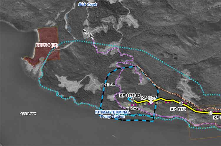
Enbridge filed a revised map of Kitimat harbour with the revised route for the Northern Gateway Pipeline and terminal in December 2012.
Enbridge Northern Gateway wants a much larger tank farm at its proposed Kitimat terminal, the company says in documents filed with the Joint Review Panel on December 28, 2012.
On that date, Enbridge filed its fifth revision of the Northern Gateway pipeline route and plans with the JRP. While for Enbridge engineers the filing may be a routine update, as surveys and planning continue, Smithers based enviromentalist Josette Weir has filed an objection with the JRP challenging the revised plans because, she says, the JRP has closed off any opportunity for intenvenors to make their own updates, calling into question once again the fairness of the JRP process.
From the documents filed with the JRP, it appears that Enbridge wants not only to expand the tank farm and adjacent areas but also to have a potentially much larger area on the shores of Douglas Channel for even more expansion in the future.
At the Kitimat terminal, Enbridge says there will now be 16 oil tanks, up from the original 11. The company also says: “The terminal site will also have some limited additional civil site development to allow for potential future site utilization.” While Enbridge proposes to keep the number of condensate tanks at three, their capacity would be increased.
In addition, Enbridge wants an enlarged “remote impoundment reservoir” to comply with the BC Fire Code, so that it would be:
• 100% of the volume of the largest tank in the tank farm, plus
• 10% of the aggregate volume of the 18 remaining tanks, plus
• an allowance for potential future tanks, plus
• 100% of the runoff from the catchment area for a 1 in 100 year, 24 hour storm event, plus
• the amount of fire water generated from potential firefighting activities at the tank farm.
Enbridge goes on to note:
An update to 16 oil tanks at the Kitimat Terminal is not expected to alter overall visibility of the marine terminal and therefore impact visual or aesthetic resources.
In her news release, Josette Wier, who describes herself as “an independent not funded intervenor in the hearing process,” says she filed a notice of motion on January 17, 2013, noting “there are numerous embedded proposed changes which have nothing to do with the route revision,” including the fact that “the tank farm in Kitimat is considerably increased from 11 to 16 tanks for the oil tanks with an almost doubled working capacity, while the condensate tanks capacity is increased by 29 per cent.”
“What does this have to do with a route revision?” she asks in the news release.
In the news release, Wier says: “that this is an abuse of process when engineering and design question period ended in Prince George last November. Not withstanding the underhanded way of presenting new evidence, re-questioning on those issues doubles the amount of work and expenses for intervenors.
“Abuse of process”
She asked the Joint Review Panel to order Northern Gateway to re-submit their proposed changes indicating clearly the ones unrelated to the route changes and describing them along with their rationale.
Wier goes on to say: “It is everyone’s guess why there is a doubling of the tank farm capacity, but certainly points out to the larger pipeline shipping volumes the company had indicated would be a possible Phase II of the project.” She says: “It looks like Northern Gateway is quietly moving into the 850,000 barrels a day proposal, twice the volume the application has been cross-examined about. It is clearly an abuse of process.”
In her actual notice of motion, Wier goes further by taking aim at the JRP itself by saying that “the Applicant [Enbridge] can make changes to the Application whenever they want. We have already seen in their July submissions inclusion of new evidence which conveniently escaped information requests. The added work and cost imposed on intervenors and the Panel seem irrelevant to the Applicant.” She complains that her requests for more information in an earlier notice of motion “was dismissed by the Panel on the grounds that my request ‘would require an unreasonable amount of effort (both by Northern Gateway and other parties reviewing the material’ …. If this argument applied to my Notice of Motion, I suggest it should apply to embedded changes buried in the Applicant’s filings of December 28, 2012.”
Rerouting at Burns Lake
A number of the other changes appear to show continued strained relations between Enbridge and First Nations, for example it says:
There is a possibility of relocating the pipeline route… further north of the Burns
Lake area to avoid proposed Indian Reserve lands that would overlap the pipeline route,.. This revision will be evaluated when further information on the proposed Indian Reserve lands is available and when further consultation with the relevant Aboriginal groups has taken place.
On the other hand the revisions also show that the pipeline will be now routed through an existing right of way through the Alexander First Nation, near Morinville, Alberta, as part of an agreement with the Alexander First Nation.
Another route change is near the Morice River, where Enbridge says
The Morice River Area alternate will generally have less effect on wildlife riparian habitat since it is located away from the Morice River and floodplain. This revision is also farther from the proposed Wildlife Habitat Area for the Telkwa caribou herd and no longer intersects any primary and secondary goat ungulate winter range polygons. However, this revision no longer parallels the Morice West Forestry Service Road (FSR) and Crystal Creek FSR and offers fewer opportunities to use existing rights-of-way. This may increase linkages between cutblock road networks and increase human access locally but does not preclude Northen Gateway from applying other methods to minimize linear feature density in this region.
Wier also complains that the Enbridge did not properly file its latest documents, asking the panel to rule that it order Northern Gateway to re-submit their last revisions submitted in December
using proper JRP evidence numbering system and “Adobe pages numbers.” The huge number of documents in the JRP system is confusing and improper filing makes it harder for intervenors and others to sort their way through new information.
A revised map of the Kitimat harbour as filed by Enbridge with the JRP in December 2012.Revised route map for the Northern Gateway pipeline as filed with Enbridge with the JRP on Dec. 28, 2012.
Kitimat, BC and New York City had one thing in common this week, the misuse and use of social media, Twitter and Facebook, that spread both accurate warnings and dangerous misinformation about an impending disaster. In the case of New York and the surrounding area, it was Superstorm Sandy that caused widespread devastation. For Kitimat it was the tsunami warning after the 7.7 earthquake off Haida Gwaii and no damage but a lot of worry for residents.
New York has a population of millions, it is the media centre for the United States, and much of the U.S. Northeast coast is still recovering from the horrendous damage from Superstorm Sandy.
Kitimat has a population of about 8,000 and my home town is off the media radar except when the Enbridge Northern Gateway pipeline issue pops up on the national assignment desks. If the October 27, 2012 tsunami from the Haida Gwaii earthquake did come up Douglas Channel to Kitimat harbour, it was so minimal that any water rise was scarcely noticed.
In one way New York (the state and the city) plus New Jersey and other states were ahead of Kitimat. In the US, there were numerous official sources on Twitter and Facebook, as well as those ubiquitous live TV news conferences with New York Mayor Michael Bloomberg or various state governors.
On October 27, neither Kitimat nor the nearby town of Terrace had any official emergency outlets on social media. In Kitimat, that may change as early as this Monday when District Council considers what happened last Saturday night.
It has been documented that there was no official response from Emergency Management British Columbia (still largely known under its former name Provincial Emergency Program) until an hour after the first earthquake report from the US Geological Survey. Only sometime later did BC’s provincial emergency officials hold a short conference call with reporters. (At the time the BC Liberals were holding a policy convention at Whistler. After the conference call, TV reporters at the convention in Whistler were doing live reports with taped clips of Attorney General Shirley Bond. It should have been easy for Bond and other senior government officials, including Premier Christy Clark–who is plummeting the polls– to hold a live news conference just as US state governors and mayors did later in the week when it came to Superstorm Sandy)
So in that hour of silence from the BC government, one question that has to be raised is: Were the tsunami warnings so completely uncoordinated–at least as far as the public is concerned– that that was one cause of the misinformation and inaccurate information on Twitter and Facebook? Or did confusing information from authorities simply compound and amplify the social media misinformation that was already spreading across British Columbia and around the world?
Here in the northwest, the two area fire chiefs Trent Bossence of Kitimat and John Klie of Terrace have said after the quake that landline phones and some cell phones were out, in some areas up to an hour after the first shock. Klie told CFTK’s Tyler Noble on Open Connection that after the landline phones came back up the Terrace fire department was flooded with calls from people “who wanted it now.” The ability of firefighters to get information was then delayed “because so many people were trying to get through.”
Kitimat has the advantage of being a small town. Emergency services already had scheduled a volunteer recruiting session last Monday night (October 29) for Emergency Social Services–the folks who run, coordinate and work in reception centres during an emergency–so it was easy to turn that meeting into a earthquake/tsunami warning post mortem. (Imagine that happening in New York?)
The most important issue on Saturday night was the false information on both Facebook and Twitter that the Kildala neighbourhood was being evacuated due to the tsunami warning. Other false information on social media indicated that the giant Bechtel work camp at the Rio Tinto Alcan Kitimat Modernization Project was also being evacuated.
As Kitimat’s Emergency Plan Coordinator Bob McLeod told the earthquake post mortem about the information on Facebook and Twitter:
Kitimat Emergency Coordinator Bob McLeod at the earthquake postmortem Oct. 29, 2012 (Robin Rowland/Northwest Coast Energy News)
“Your aim is to be saving people, and you’re not saving people. There was one case where someone was going around banging on doors in Kildala, telling them to get out. I think it was over when he was in the lockup that night. But this is the type of foolishness that goes on. You have people going on Facebook saying ‘Alcan’s been evacuated. they’re evacuating Kildala.’ I am going to be generous and say it is misinformation… It was a blatant lie. And that does not help.”
(For those outside Kitimat you can check the town on Google maps) As seen on this screen grab, Kildala is a low lying part of town. The area north of Highway 37 is higher on a hill. Closer to the ocean at Douglas Channel are the Bechtel/RTA Kitimat Modernization Project work camps.
After driving from the village to the town, McFarlane told the meeting that he stopped at the town viewpoint where “people were telling me they had already been evacuated out of the Kildala neighbourhood, so my first stop after that was the fire department.” The fire hall is about a couple of blocks from the viewpoint, so it was easy to get accurate information from the fire department.
McFarlane continued, “I found the night of the earthquake that no information is just as bad as wrong information. People were calling me on my cell saying why does the Kitimat Daily say we have to evacuate.” That is because the Daily republished a warning from the Pacific Tsunami Warning Centre that “said tsunami warning, evacuation for the north coast. People were saying we’re on the north coast, we got to go.”
I was about fifteen to twenty minutes behind McFarlane in reaching town. (I did not leave Kitamaat Village until after we heard the first tsunami warning.) As soon as I got to back in cell range, my cell phone started to beep with saved messages from my TV and radio news clients calling for information. When I got to my home office, my landline was still dead and would be for about another twenty minutes. The only source of information at that point was Google News, Facebook and Twitter.
I saw the initial, and it turns out general, warning from the Pacific Tsunami Warning Center. Soon I was also getting what I hoped was more specific information on my marine radio from the Canadian Coast Guard Prince Rupert communications station.
But that, too was somewhat confusing. That Coast Guard advisory mentioned various zones, for example, Zone A and Zone B, but there was little specific context and that point I had no idea what Zone A meant. Prince Rupert Coast Guard Radio then went on to say evacuate low lying coastal areas. (transcript below)
With that confusion, and mindful of “when in doubt, leave it out,” I did not mention the zone system in any information I posted on Facebook and Twitter that night. I only retweeted official information or tweets from reporters I knew and trusted (and I did not see any tweeted official information from the province with a link to the page that identifies the official tsunami zones)
From the interview on CFTK, it appears that both the Kitimat and Terrace fire departments were also getting inadequate information.
“We went to our normal place to look EM BC (Emergency Management BC) and there was nothing there,so we went to Plan B to get information and went on from there,” Bossence told Tyler Noble.
Klie said: “We struggle with that every disaster big or small. Social media, I think emergency organizations are trying to tap into more and more. Up north we may be a little behind the eight ball but sure enough Twitter and Facebook information is out there instantly. Looking at Facebook with my son, I saw that they were evacuating whole cities and I knew that was not true. Because of my experience I can filter some of the information, but there is so much information out there that it’s hard to filter what’s real and not real. It’s an area where emergency coordinators have to get into because its the fastest way of getting information out.”
“Once the phone system came back online at the Fire Hall we got a flood of phone calls,” Bossence told CFTK, “it was nonstop and it was people wanting to know. ‘What’s going on? What are we going to do? Are we leaving?’ and they’re giving us ‘This is what is what I’m reading, this is what I’m being texted, on Facebook they’re saying we’re supposed to evacuate’ adding to that we had an individual going around claiming he was a fire department, he was going door to door and telling people to evacuate. That was the added issue we had to deal with. It was definitely misinformation and a sense of urgency that was coming out through the social network (and eventually the media) was big problem for us.”
In Kitimat, I was told about the man going door to door with inaccurate information and as soon as I confirmed it with reliable official sources, I posted that on both Twitter and Facebook, emphasizing there was, at that time, no evacuation order.
But every situation is different. In contrast, in Superstorm Sandy, another story about men going door to door in Williamsburg, a section of Brooklyn was not true, as can be seen in an article summing problems with Twitter in New York, where Jared Keller of Bloomberg reported
I experienced this firsthand during Hurricane Sandy. After retweeting a message warning about muggers in Williamsburg dressed as Con Ed workers as an experiment, I received two sceptical responses checking the claim within 15 minutes, both from people who work in the media industry and spend a significant amount of time on Twitter. Within an hour, I received a mass text message from friends of mine who aren’t completely plugged into the social Web with the same warning: “I just read a news alert of two separate reports of people posing as coned workers, knocking on people’s door and robbing them at gunpoint in Williamsburg. I just want to pass along the info. Stay safe and maybe don’t answer your door.” Two other friends responded with thanks.
Keller goes on to stay “I know a lot of people, especially on Facebook, who end up believing whatever they see first,” says Kate Gardiner, a social media journalist. “It’s almost impossible to track something back to its point of origin there.”
With the earthquake and tsunami warning Saturday night, Twitter misinformation spread internationally. The first hashtag I saw was #bcquake, but as the the tsunami warning gained traction (especially after the warning was extended from BC and Alaska to Washington, Oregon and California and then to Hawaii) the more common hashtag #tsunami became prominent. As people outside BC began tweeting, they began using #Canadaquake and soon #prayforcanada also began to trend. Completely inaccurate information spread on #prayforcanada (believed to have originated in Indonesia) that it was Vancouver, not the north coast that had been hit by the 7.7 magnitude earthquake.
Are you in the Zone?
At this point, one question has to be asked. The spread of information, first the well-intended but wrong, second just rumour and third, the deliberately misleading, has been seen in social media not only during the earthquake and tsunami on the West Coast last weekend, and during Superstorm Sandy on the East Coast but all the way back to the 2004 Christmas tsunami in Southeast Asia.
For the west coast in 2012, however, how much of the problem of misinformation on social media during the earthquake and tsunami warning was the fault of confusing information from the authorities? Just how were people going to interpret such general terms as “north coast” and “low lying areas.”?
From the BC Provincial Emergency Program you have to ask “What is Zone A?” It turns out by checking a day or so later that the province of British Columbia has created Tsunami Identification Zones.
Before October 27, it is likely no one outside of the provincial bureaucracy had ever heard of the provincial tsunami zones. At that time no one in BC, either on Twitter or Facebook or through the media was identifying the BC Tsunami Zones for the public. Later on, the television networks put up maps showing Zones A and B —but that was only good if you had power and were watching the right channel. Kitimat Daily and Terrace Daily posted an official update at 10:42 long after the danger was past explaining the Zone system. It was no good at all if you were listening to news reports on radio or to Prince Rupert Coast Guard Radio on a fishing boat and had no access to the actual maps.
Compounding the confusion is that the US system appears to be very different from the Canadian.
Also the US system has two levels of warning. The Pacific Tsunami Warning Center sends out general warnings but hands over for a more specific warning map from the Alaska -based West Coast and Alaska Pacific Tsunami warning centre. It uses its own system of lettered and numbered zones for the west coast of North America. (See the Oct 27 tsunami advisory here Note it is a Google maps plugin.)
Fisheries management zones as defined by the Department of Fisheries and Oceams (DFO)
So in case of a tsunami warning, Kitimat is in Zone B for the province of British Columbia and the Provincial Emergency Program and in Zone BZ921 for the West Coast and Alaska Tsunami Warning Centre. For the much more familiar fisheries management areas Kitimat is in Zone 6 (which of course has nothing to do with a tsunami, it’s simply the coastal zone system everyone is familiar with)
Adding to the confusion is the fact that the EM British Columbia map shows Terrace, far inland up the Skeena River is considered in Zone A, along with Prince Rupert for tsunami warnings (if a tsunami was big enough to reach Terrace along the Skeena River valley, then I can only assume that much of the west coast of North America would have already been wiped out).
The Monday Post mortem
At the Monday, October 29 post mortem, when McLeod outlined the events of October 27, he began by looking back three weeks, saying, “I have feeling of frustration about a couple of things. October 7, I took 4,000 brochures [How Prepared Are you if Disaster Strikes?] down to the post office to mail out to the residents of Kitimat, They were all delivered by the post office. On Sunday, I had people coming to me and saying what are we supposed to do in the case of an earthquake? It is really, really difficult to get people interested.”
McLeod said that after he felt the earthquake, he went online to check information and then went up to the fire hall, which is Kitimat’s emergency coordination centre. There he met Fire Chief Bossence, his deputy, the RCMP detachment commander Staff Sergeant Steve Corp and representatives from Bechtel and the Rio Tinto Alcan modernization project.
“For the first little while we were going on line trying to get information. The usual method of dissemination getting information it comes from the West coast and Alaska tsunami warning system, then it goes to Victoria, Victoria gives it to the geophysical specialists and they will confirm or deny what ever the information and then it goes to the Provincial Emergency Program and they shoot it out to coastal communities.
“While in this case you’re working with what you find out from different sources and you are trying to determine how reliable these sources are.”
“In our case, for me the first thing you do when you get word of an impending tidal wave [tsunami] action is check the tide. If you’re on a high tide, it’s a different situation than a low tide
“The movie version of a tidal wave is this 50 foot mountain of water roaring along and this is not what is going to happen particularly in Douglas Channel because of the depth. So you are going to see a surge such as we saw in Japan and it will be an increasing surge of water.
“We were told that potentially some sort of surge hitting Langara [the northern most island in Haida Gwaii) at 9:16, 9:16 came and went and there was no notification of a noticeable surge of water. So were down to a non event and we were on a receding tide.” (See advisory below)
“Misinformation going out is not helpful,” McLeod said. “You’ve got to set up a stream of how you get information out to people and it’s a valid point. The District Website, the Facebook page, something like that can get information out. But again if you lose power where do get it? Text can work even locally with cell phones. if you’re in a dead area with a cell phone, you can still get text”
McLeod then asked the audience, mainly people ranging from their thirties to seventies if they text. Only four or five people put up their hands. “You people are going to be saved, the rest of us…” McLeod quipped.
If a conclusion can be drawn from the earthquake and tsunami warning in the Kitimat region on October 27, it’s not just that in an emergency inaccurate, incomplete or malicious information can spread a the speed of light on social media, it’s worse that incomplete, inadequate and confusing information from the authorities is amplified and distorted by rapid posting on social media. That concept is not new for anyone who has tried the phone chain game where the outcome is often completely different from the start.
If Gardiner is correct when she says “I know a lot of people, especially on Facebook, who end up believing whatever they see first,” the BC government delays made everything worse. People Tweeted the first thing they saw and the first thing people saw came from multiple and often conflicting sources. Add that to those Tweets that were exaggeration, rumour and lies.
The problem in 2012 it is not one person talking to one person talking to one person, it is a Tweet or Facebook posting that go out to thousands, or millions of people and that’s a lot more dangerous.
McLeod said the post mortem who said emergency services is trying to get more information out to public, but he added. “The unfortunate part is that if you publish it this week, by Christmas no one will remember. If you start throwing it out every week, it becomes like a stop sign at the end of the street. Nobody sees it.”
(Coming next. If Kitimat had to evacuate)
Transcript of Prince Rupert Coast Guard Radio tsunami warning.
Pan pan. Pan pan. This is Prince Rupert Coast Guard Radio, Prince Rupert Coast Guard Radio. Warning for coastal British Columbia issued by Environment Canada on behalf of the British Columbia Provincial Emergency Program at 2057 Pacific Daylight Time Saturday 27 October. Tsunami warning for Zone A, the north coast and Haida Gwaii,Zone B, the central coast and including Bella Coola, Bella Bella and (unintelligible). A tsunami warning has been issued, if you are in a low-lying area coastal area, you are at risk and must move to higher ground or inland now.
Do not return until directed to do so. Closely monitor local radio stations for additional information from local authorities. Please minimize phone use in affected areas, for further information contact the provincial emergency program at website www. papa echo papa period bravo charlie period charlie alpha.Prince Rupert Coast Guard Radio over.
TSUNAMI BULLETIN NUMBER 003
PACIFIC TSUNAMI WARNING CENTER/NOAA/NWS
ISSUED AT 0341Z 28 OCT 2012
THIS BULLETIN APPLIES TO AREAS WITHIN AND BORDERING THE PACIFIC
OCEAN AND ADJACENT SEAS…EXCEPT ALASKA…BRITISH COLUMBIA…
WASHINGTON…OREGON AND CALIFORNIA.
… TSUNAMI INFORMATION BULLETIN …
THIS BULLETIN IS FOR INFORMATION ONLY.
THIS BULLETIN IS ISSUED AS ADVICE TO GOVERNMENT AGENCIES. ONLY
NATIONAL AND LOCAL GOVERNMENT AGENCIES HAVE THE AUTHORITY TO MAKE
DECISIONS REGARDING THE OFFICIAL STATE OF ALERT IN THEIR AREA AND
ANY ACTIONS TO BE TAKEN IN RESPONSE.
AN EARTHQUAKE HAS OCCURRED WITH THESE PRELIMINARY PARAMETERS
ORIGIN TIME – 0304Z 28 OCT 2012
COORDINATES – 52.9 NORTH 131.9 WEST
DEPTH – 10 KM
LOCATION – QUEEN CHARLOTTE ISLANDS REGION
MAGNITUDE – 7.7
EVALUATION
NO DESTRUCTIVE WIDESPREAD TSUNAMI THREAT EXISTS BASED ON
HISTORICAL EARTHQUAKE AND TSUNAMI DATA.
HOWEVER – THE WEST COAST/ALASKA TSUNAMI WARNING CENTER HAS
ISSUED A REGIONAL WARNING FOR COASTS LOCATED NEAR THE EARTHQUAKE.
THIS CENTER WILL CONTINUE TO MONITOR THE SITUATION BUT DOES NOT
EXPECT A WIDER THREAT TO OCCUR.
THIS WILL BE THE ONLY BULLETIN ISSUED FOR THIS EVENT UNLESS
ADDITIONAL INFORMATION BECOMES AVAILABLE.
THE WEST COAST/ALASKA TSUNAMI WARNING CENTER WILL ISSUE PRODUCTS
FOR ALASKA…BRITISH COLUMBIA…WASHINGTON…OREGON…CALIFORNIA.
BULLETIN
PUBLIC TSUNAMI MESSAGE NUMBER 2
NWS WEST COAST/ALASKA TSUNAMI WARNING CENTER PALMER AK
834 PM PDT SAT OCT 27 2012
THE MAGNITUDE IS UPDATED TO 7.7. THE WARNING ZONE REMAINS THE
SAME.
…THE TSUNAMI WARNING CONTINUES IN EFFECT FOR THE COASTAL
AREAS OF BRITISH COLUMBIA AND ALASKA FROM THE NORTH TIP OF
VANCOUVER ISLAND BRITISH COLUMBIA TO CAPE DECISION
ALASKA/LOCATED 85 MILES SE OF SITKA/…
…THIS MESSAGE IS INFORMATION ONLY FOR COASTAL AREAS OF
CALIFORNIA – OREGON – WASHINGTON AND BRITISH COLUMBIA FROM
THE CALIFORNIA-MEXICO BORDER TO THE NORTH TIP OF VANCOUVER
ISLAND BRITISH COLUMBIA…
…THIS MESSAGE IS INFORMATION ONLY FOR COASTAL AREAS OF
ALASKA FROM CAPE DECISION ALASKA/LOCATED 85 MILES SE OF
SITKA/ TO ATTU ALASKA…
A TSUNAMI WARNING MEANS… ALL COASTAL RESIDENTS IN THE WARNING
AREA WHO ARE NEAR THE BEACH OR IN LOW-LYING REGIONS SHOULD MOVE
IMMEDIATELY INLAND TO HIGHER GROUND AND AWAY FROM ALL HARBORS AND
INLETS INCLUDING THOSE SHELTERED DIRECTLY FROM THE SEA. THOSE
FEELING THE EARTH SHAKE… SEEING UNUSUAL WAVE ACTION… OR THE
WATER LEVEL RISING OR RECEDING MAY HAVE ONLY A FEW MINUTES BEFORE
THE TSUNAMI ARRIVAL AND SHOULD MOVE IMMEDIATELY. HOMES AND
SMALL BUILDINGS ARE NOT DESIGNED TO WITHSTAND TSUNAMI IMPACTS.
DO NOT STAY IN THESE STRUCTURES.
ALL RESIDENTS WITHIN THE WARNED AREA SHOULD BE ALERT FOR
INSTRUCTIONS BROADCAST FROM THEIR LOCAL CIVIL AUTHORITIES.
EARTHQUAKES OF THIS SIZE ARE KNOWN TO GENERATE TSUNAMIS.
AT 804 PM PACIFIC DAYLIGHT TIME ON OCTOBER 27 AN EARTHQUAKE WITH
PRELIMINARY MAGNITUDE 7.7 OCCURRED 25 MILES/40 KM SOUTH OF
SANDSPIT BRITISH COLUMBIA.
EARTHQUAKES OF THIS SIZE ARE KNOWN TO GENERATE TSUNAMIS.
IF A TSUNAMI HAS BEEN GENERATED THE WAVES WILL FIRST REACH
LANGARA ISLAND BRITISH COLUMBIA AT 916 PM PDT ON OCTOBER 27.
ESTIMATED TSUNAMI ARRIVAL TIMES AND MAPS ALONG WITH SAFETY RULES
AND OTHER INFORMATION CAN BE FOUND ON THE WEB SITE
WCATWC.ARH.NOAA.GOV.
TSUNAMIS CAN BE DANGEROUS WAVES THAT ARE NOT SURVIVABLE. WAVE
HEIGHTS ARE AMPLIFIED BY IRREGULAR SHORELINE AND ARE DIFFICULT TO
FORECAST. TSUNAMIS OFTEN APPEAR AS A STRONG SURGE AND MAY BE
PRECEDED BY A RECEDING WATER LEVEL. MARINERS IN WATER DEEPER
THAN 600 FEET SHOULD NOT BE AFFECTED BY A TSUNAMI. WAVE HEIGHTS
WILL INCREASE RAPIDLY AS WATER SHALLOWS. TSUNAMIS ARE A SERIES OF
OCEAN WAVES WHICH CAN BE DANGEROUS FOR SEVERAL HOURS AFTER THE
INITIAL WAVE ARRIVAL. DO NOT RETURN TO EVACUATED AREAS UNTIL AN
ALL CLEAR IS GIVEN BY LOCAL CIVIL AUTHORITIES.
PACIFIC COASTAL REGIONS OUTSIDE CALIFORNIA/ OREGON/ WASHINGTON/
BRITISH COLUMBIA AND ALASKA SHOULD REFER TO THE PACIFIC TSUNAMI
WARNING CENTER MESSAGES FOR INFORMATION ON THIS EVENT AT
PTWC.WEATHER.GOV.
THIS MESSAGE WILL BE UPDATED IN 30 MINUTES OR SOONER IF
THE SITUATION WARRANTS. THE TSUNAMI MESSAGE WILL REMAIN
IN EFFECT UNTIL FURTHER NOTICE. FOR FURTHER INFORMATION STAY TUNED
TO NOAA WEATHER RADIO… YOUR LOCAL TV OR RADIO STATIONS… OR SEE
THE WEB SITE WCATWC.ARH.NOAA.GOV.
$$
Did the media over react to the earthquake and tsunami warning?
There were also numerous Tweets on October 27, accusing the media of over reacting. The Haida Gwaii quake was 7.7 magnitude. Compare that to the Haiti earthquake on January 12, 2010 which was 7.0. The Christ Church, New Zealand earthquake on February 27, 2011 which caused major damage was 6.3 magnitude. So the Haida Gwaii earthquake was a major event. The tsunami warning that eventually reached as far off as Hawaii had to be taken seriously.
Fortunately Haida Gwaii is sparsely populated and there was minimal damage largely because most of the houses and buildings are wood and can absorb some of the shaking from an earthquake.
Given the tsunami damage in Southeast Asia in 2004 and in Japan in 2011, no media organization could ignore the developing story.
If there is justifiable criticism, it is that some media over hyped the story in the beginning, rather acting to reassure the public in a responsible manner. But the media that over hyped the earthquake and tsunami are the kind that would over hype any story. That is generally the result of management listening to “TV doctors” and media consultants who urge over hyping to increase ratings. (It often works). But those who, quite early in the event, who tweeted that the media was overreacting, were themselves guilty of overreaction in their Tweets.
A map from the Geological Survey of Canada showing the line of a possible seismic fault on Douglas Channel (Geological Survey of Canada)
Updates with statement from Natural Resources Canada, new filings by Enbridge Northern Gateway and the Attorney General of Canada (in box below)
The Geological Survey of Canada has identified a tsunami hazard and a possible seismic fault in Douglas Channel near Kitimat. A scientific paper by the Geological Survey and the Department of Fisheries and Oceans says there were once two giant landslides on Douglas Channel that triggered major tsunamis and that the landslides were possibly caused by an earthquake on the fault line.
Kitimat is the proposed site of the Enbridge Northern Gateway project and at least three liquified natural gas projects.
If the projects go ahead, hundreds of supertankers with either bitumen or LNG will be sailing in the channel for years to come.
A filing by the Attorney General of Canada with the Northern Gateway Joint Review Panel is asking the JRP for leave to file late written evidence long after the original deadline of December 2011. The Attorney General’s motion was filed on August 17, but went unnoticed until the Kitimat environmental group Douglas Channel Watch brought the matter up with District of Kitimat Council tonight (Sept. 17).
Appended to the Attorney General’s motion is a copy of a scientific paper from the Geological Survey “Submarine slope failures and tsunami hazards in coast British Columbia: Douglas Channel and Kitimat Arm” by Kim W Conway, J.V. Barrie of the Geological Survey and Richard E. Thomson of the Department of Fisheries and Oceans.
The report says the scientists discovered “evidence of large submarine slope failures in southern Douglas Channel.”
It goes on to say: “The failures comprise blocks of bedrock and related materials that appear to have been detached directly from the near shore off Hawkesbury Island.” Hawkesbury Island and many of the other islands in Douglas Channel are built up with material left over from the ice age glaciers and thus are vulnerable to displacement and landslides.
The research identified two slides, one estimated at 32 million cubic metres and a second of 31 million cubic metres. The report goes on to say that the discovery of an “apparently active fault presents the possibility that they may have been triggered by ground motion or surface rupture of the fault during past earthquake events.”
The slope failure landslides are covered with thick layers of mud, and that, the scientists say, could mean that the failures could be ancient, possibly occurring 5.000 to 10,000 years ago. Further research is needed to confirm the date of the giant slides.
What is worrying about the discovery is that fact that there were two recent submarine slope failures on the Kitimat Arm of Douglas Channel. both creating tsunamis. The first slope failure occurred on October 17, 1974, triggering a 2.4 metre tsunami at low tide. Then on April 27, 1975 there was a second slope failure near low tide on the northeast slope of the Kitimat Arm that generated an 8.2 metre tsunami. The 1975 tsunami destroyed the Northland Navigation dock near Kitimat and damaged the Haisla First Nation docks at Kitamaat Village.
The paper says that “Additional geological research is required to better delineate the age of the submarine failures, their triggers, and their mechanisms of emplacement.”
Urgent new research is underway and the filing by the Attorney General says when the Department of Justice requested leave to file late evidence says it anticipates that the further research by DFO is expected to be completed by November 1. The Natural Resources Canada Earth Sciences Sector began a national assessment of submarine slope failures in Canada in late 2011 and completion of the Pacific portion of this assessment is targeted for December of 2012.
The Attorney General’s filing says that DFO is now modelling “potential wave heights and speeds that may have resulted from the two previously unrecognized submarine slope failures in the Douglas Channel.” The model will use high resolution scans of the Douglas Channel seafloor to create the models.
The survey of Douglas Channel in 2010 suggests the possible existence of a fault immediately to the south of the second ancient slide on Hawkesbury Island.
The GSC paper says that evidence for a continuous fault was observed by aligned stream beds and fractures on the south end of Hawkesbury Island, about four kilometers from the site of the second ancient slide. The possible fault then appears to terminate far to the south near Aristazabal Island on the Inside Passage. The Geological Survey says that eleven small earthquakes, all less than magnitude three, have appeared with 20 kilometres of the suspected fault over the past 25 years.
The paper says that the scientists conclude that the slides appear to have left very steep slopes at or near the shoreline that could be susceptible to future failure events.
A large potential slope failure has been identified near one of the ancient slides….
in the absence of additional evidence, the fault must be considered a potential trigger for the submarine failure events….the triggers for the failures have not been defined; however, their proximity to a potentially active fault represents one potential source. The failures probably generated tsunamis during emplacement and conditions exist for similar failures and associated tsunamis to occur along this segment of Douglas Channel in the future.
The scientists say that detailed tsunami modelling is underway to
provide an improved understanding of the generation, propagation, attenuation, and likely coastal inundation of tsunami waves that would have been created by slides… or that could be generated from similar future events. Only through the development and application of this type of tsunami modelling will it be possible to gauge the level of hazard posed by the identified submarine slope failures to shore installations and infrastructure, or to devise ways to effectively mitigate the impacts of future such events.
The filing by the Attorney General offers to bring the scientists to the Joint Review Panel to appear as witnesses sometime during the final hearings.
The filing notes that the current evidence tendered to the JRP by Enbridge, and other parties does demonstrate the potential for marine geohazards and associated tsunami events. Enbridge’s design of the proposed Northern Gateway marine terminal and its operational plans took into consideration the current state of knowledge of geohazards including earthquakes and tsunamis at the time of filing. Enbridge has said it would undertake further geological survey during the detailed design phase for the terminal.
At the time Natural Resources Canada noted that the information provided for the Environmental Review was sufficient at that time, now the Attorney General says:
the geographic scope for potential landslide induced tsunami hazards is now better understood to extend beyond the Kitimat Arm. NRCan and DFO seek by this motion to ensure that this Panel, and the Parties before the Panel, have the most up to date information on geohazards in the Douglas Channel.
Updates: DFO report in October will clarify the tsunamis in Douglas Channel.
Statement from Natural Resources Canada
Natural Resources Canada sent this statement to Northwest Coast Energy News on September 20, 2012.
In reference to the opening paragraph of your September 18th editorial entitled Geological Survey of Canada identifies tsunami hazard: Possible fault line on Douglas Channel, we would like to clarify the following. Although the ancient large submarine slope failures which our scientists have identified may have caused tsunamis, this is not a certainty. It is important to note that Fisheries and Oceans Canada is currently studying this information to model potential wave heights and speeds.
As our report states, only through the development and application of this type of tsunami modelling will it be possible to gauge the level of hazard posed by the identified submarine slope failures to shore installations and infrastructure, or to devise ways to effectively mitigate the impacts of future such events.
Northern Gateway response filed on August 31, 2012
Enbridge Northern Gateway filed this response to the Attorney General’s motion on August 31.
This motion of the Federal Government Participants requests permission to file late evidence consisting of a report entitled “Submarine Slope Failures and
Tsunami Hazard in Coastal British Columbia: Douglas Channel and Kitimat Arm” regarding tsunami hazard and additional modelling work based on that report.
Northern Gateway does not object to the filing of this late intervenor evidence.
It may be relevant and Northern Gateway accepts that theevidence could not be filed earlier. However, Northern Gateway would like the opportunity to conductits own additional modelling work which it would be prepared to provide to DFO for comment prior to the filing of any modelling work by DFO in this proceeding.
Attorney General response to Enbridge on September 10, 2012.
The Attorney General of Canada responded to Enbridge by saying:
Attorney General responds DFo is prepared to await filing its subseqent modelling work in these proceedings until such time as it has received, reviewed and commented upon additional modelling work as proposed by NGP Inc.
DFO nots howeverand wishes to alert the JRP that the NGP INc proposed may occasion a delay in the filing of the DFO moedling work which is now proposed for filing on or about October 31, 2012. Delivery of DFO comments as requested will depend on when DFO received the NGP Inc modelling work, the time and resources required by DFO to study and provide comments on the NGP modelling work and unforeseen factors which may have an impact upon completion the commentary. As such,
DFO is prepared to file its modeling work on or about October 31, 2012, but subject to any further direction or request by the panel.
Geological Survey of Canada map of Douglas Channel showing the area surveyed which discovered the landslides and possible fault line. (Geological Survey of Canada)
;
;
Map from the Geological Survey of Canada showing the landslides on the Kitimat Arm which triggered tsunamis in 1974 and 1975 (Geological Survey of Canada)
;
;
Map from the Geological Survey of Canada showing the giant slide on the southern tip of Hawkesbury Island. (Geological Survey of Canada)
;
Map from the Geological Survey of Canada showing the second giant slide on the coast of Hawkesbury Island on Douglas Channel (Geological Survey of Canada)
There’s one question about the Enbridge Northern Gateway project that many people ask and few can answer: Who is responsible for the port of Kitimat? Who would be liable should there be a disaster in the port? Nobody really knows.
Unlike many harbours in Canada, the port of Kitimat is “private,” although as the District of Kitimat says, “Transport Canada and other federal agencies continue to regulate navigation, security and environmental safety.” Kitimat has promoted that private status as an economic advantage.
If there’s a dispute, the question of responsibility and liability would probably end up in the Supreme Court of Canada, with the justices sorting out a historic puzzle. Or perhaps that historical puzzle could mean that the future of the port of Kitimat might be decided by the next B.C. provincial election.
Most of the other harbours in Canada are the responsibility of Ports Canada, a branch of Transport Canada or run by (usually not-for-profit) semi-public port corporations or local harbour commissions.
To find out why Kitimat is one of the few private ports in Canada, the first thing to do is watch Eliza Kazan and Bud Schulberg’s classic 1954 multiple Oscar winning movie, On the Waterfront, starring Marlon Brando, about how the mob ran the New York docks.
What has On the Waterfront got to do with Kitimat? It goes back to when the then Aluminum Company of Canada/Alcan (now Rio Tinto Alcan) was planning the Kitimat project; much of that work was done in New York both by employees and consultants. It was in 1949, that Malcolm Johnson, a New York Sun reporter, wrote a Pulitzer Prize winning series of investigative reports called “Crime on the Waterfront,” exposing corruption and Mafia involvement with the docks and the longshoremans’ union. The movie was based, in part, on that investigative series.
So in its planning, Alcan was determined that the longshore unions would not be involved in running the docks in Kitimat. The publicly stated reason has always been that Alcan wanted a seamless 24/7 operation that would be integrated with the aluminum smelter. Alcan would sign a collective agreement with the United Steelworkers that covered both the smelter and the docks. (CAW 2301 now represents most of the workers at the Kitimat smelter.)
When the Kitimat project was being finalized in 1949 and 1950 at the height of the Cold War, aluminum was a strategic commodity, security was high on the agenda, and it was not just the Soviet bloc but the mob as well that worried the authorities.
Add two factors. First, in 1949 the province of British Columbia was anxious to promote what would today be called a “mega-project.” Second, in the post-war era when corporations were relatively enlightened compared to today, Alcan was determined not to create the traditional “company town.”
To promote private-sector development of both hydro-electricity and aluminum, B.C. signed a rather loosely worded agreement with Alcan, noting that the project was going on “without investment by or risk to the government.” That agreement was implemented by the Legislative Assembly of B.C. by an equally wide open Industrial Development Act. One aim of both was try to ensure that future “socialists” would not expropriate the project.
Industrial township
With the province handing over the Crown land at the head of Douglas Channel at a very nominal price to Alcan, next came the creation of the District of Kitimat. With the town under construction, with few buildings and a small population, under normal B.C. practice, the area would be “unincorporated” and would not have a municipal government. But Alcan and the province came up with a new concept, which they called “an industrial township,” which would allow a municipal government to be established in anticipation of future growth.
The act that established the District of Kitimat put the boundaries outside the land owned by Alcan (excluding land reserved for the Haisla Nation).
The District of Kitimat has some legal responsibility for “wharfs” at the port of Kitimat. At council meetings, the environmental group, Douglas Channel Watch, has raised the question of the district’s responsibility and liability in case of an Enbridge incident but there’s been no definitive response from district staff. There is no municipal harbour commission as there is in other jurisdictions.
Up until recently, it was a convenient arrangement for everyone involved. Alcan, Eurocan and Methanex ran their dock operations without any interference, beyond standard Transport Canada oversight.
Things began to change in 2007, when the Rio Tinto Group bought Alcan, creating Rio Tinto Alcan. A couple of years ago, a senior staff source in the Canadian Auto Workers explained it to me it this way. “Alcan was a big corporation, but Alcan was a corporation with a big stake in Canada. As a union, we could do business with them. Rio Tinto is a transnational corporation with businesses in lots of countries but no stake in any of them. So it’s a lot harder now.”
With the Rio Tinto acquisition of Alcan, things tightened up in Kitimat. Negotiations between the District and RTA for the District to obtain more land stalled. Access to the estuary and other RTA lands that had been somewhat open under Alcan became more restrictive. In 2010, the Eurocan paper mill shut down along with its dock. In 2011, Rio Tinto bought the dock from West Fraser, owner of Eurocan. The Kitimat community noted that when the dock was repainted, it said just “Rio Tinto.” not “Rio Tinto Alcan” and that led to lots of gossip and wondering about what the Rio Tinto Group really plans for Kitimat. Last fall, Shell Canada purchased the former Methanex dock for part of its liquified natural gas operations.
With the Enbridge Northern Gateway project, the BC LNG project at North Cove and the KM LNG project at Bish Cove all along the shore of Douglas Channel and within the boundaries of the District of Kitimat which extends as far south as Jesse Lake, the question that has to be asked is, what happens now? If the Enbridge project is built, it will start just beyond the boundaries of the land owned by Rio Tinto Alcan.
That old arrangement between Alcan and the District of Kitimat is facing many new challenges.
The district once had a harbour master, but the position was eliminated because he had nothing to do. Alcan owned its docks, Alcan managed the docks and Alcan union employees worked on the docks. Later came the Eurocan (now owned by Rio Tinto) and Methanex (now owned by Shell) docks, again owned and operated by private corporations.
The District of Kitimat, nominally in charge, was content to sit back and collect taxes.
With the Enbridge Northern Gateway project, the B.C. LNG project at North Cove and the KM LNG project at Bish Cove all along the shore of Douglas Channel and within the boundaries of the District of Kitimat, the question that has to be asked is, what happens now? If the Enbridge project is built, it will start just beyond the boundaries of the land owned by Rio Tinto Alcan.
In Canada, ports and harbours are normally under federal jurisdiction and Transport Canada has oversight. But Alcan’s “private port” and the District of Kitimat were created by acts passed by the B.C. government.
The original agreement between the province and Alcan mentions an “aluminum plant” and “low-cost electrical power,” it doesn’t mention bitumen or liquified natural gas. Those provincial acts do not cover bitumen, supertankers and liquified natural gas.
B.C. Opposition Leader Adrian Dix has made it clear that his New Democratic Party opposes the Northern Gateway project. The federal government has said the province can’t really do anything to stop Enbridge Northern Gateway once Stephen Harper has decided that the pipeline project is in the national interest.
At this moment, Dix is a “contender” for the premiership, with Christy Clark and the B.C. Liberals dropping in the polls and with key members of her government deciding not to run in the election next spring.
So, if, as expected, Adrian Dix becomes the next B.C. premier, he has one very strong hand to play. Any act can, with proper legal advice, be amended by the B.C. legislature. That means the “socialists” so feared by Alcan and the premier of the day, Byron “Boss” Johnson, could alter the 1949 law. That in turn may upset the decades-old arrangement that created the private port which Enbridge is banking on.
Kitimat’s “Hospital Beach” on March 17, 2012, with the construction at the Rio Tinto Alcan plant in the background, before the area was closed to the public. (Robin Rowland)
The hottest issue in Kitimat this summer is water, not oil. For us, this summer can be summed up by saying: “Water, water everywhere, but you can’t get there from here.”
Even with David Black’s proposal for an oil refinery on a hill 25 kilometres north of Kitimat, residents here know that the Enbridge Northern Gateway debate has gone on for years and will go on for many years to come.
As environmentalists worldwide celebrate the beauty of Douglas Channel, and decry the dangers that tanker traffic could pose to the channel, many people in Kitimat are cut off from the waterfront.
At the District of Kitimat Council meeting on August 7, Coun. Mario Feldhoff introduced a motion calling for a study in an effort to find ways to launch kayaks into the ocean. Yes that’s right, according to members of council, you can’t even drop a kayak into the waters of Douglas Channel unless you pay the kind marina a launch fee usually charged for larger fishing boats. Kitimat is down to only one expensive boat launch.
In 2010, there were three marinas in Kitimat: one privately operated at a place called Moon Bay, a large marina owned by the Kitimat Stikine Regional District at MK Bay and a small marina at Minette Bay, also the site of a log export operation. There was also a boat launch on land known as “Alcan beach” or “Hospital Beach” on property owned by Rio Tinto Alcan (RTA) near the aluminum smelter. Hospital Beach is the only beach in Kitimat (named because it is on the site of the town’s original hospital in the 1950s). Moon Bay was located on land owned by RTA, and in April 2010, it ordered the marina shut down.
Some people who moored their boats at Moon Bay moved to MK Bay (if there was room). Others hauled their boats out of the water and parked them in their driveways. In the ensuing two years, there have been increasing stories about mismanagement at MK Bay and complaints about moorageand launching fees that are much higher than elsewhere in the province.
This spring, citing construction at the smelter, RTA closed public access to Hospital Beach for picnics, kids’ play and just looking at the water. That meant the boat launch was also off-limits. RTA spokesperson Nyce said:
The Rio Tinto Alcan site is now a full fledged construction zone with constant vehicular and heavy duty construction traffic. To that end, and as Rio Tinto Alcan representatives have always said, during construction we will take necessary steps to eliminate potential hazards to the general public on our road including access to Hospital Beach. Therefore, Hospital Beach will be closed to the public until construction is complete or until we believe it is more safe for public access.
Before access was closed, if a Kitimat resident was driving to Hospital Beach, they pass what was once a rough logging road that snaked its way along the shores of Douglas Channel toward Bish Cove. Now Bish Cove is the site of the Kitimat LNG project terminal. As part of the construction process, KM LNG upgraded the road. However, as the pace of construction increases KM LNG is now limiting access to the road and its views of the channel.
Why is there no access to the waterfront, or for that matter to the magnificent Kitimat River estuary?
It goes back to 1950 when the province of B.C., in a loosely worded agreement with what was then Alcan and in an equally non-specific Industrial Development Act, handed over the land where Kitimat is now to the company.
That included almost all the waterfront and the estuary. On the estuary, there is one small area of land that is a reserve for the Haisla Nation and one small area not in RTA domain owned by the District of Kitimat — but there is no right of way through a potential private development. Over the years, and especially since Rio Tinto took over Alcan, there have been more and more restrictions placed on access to Kitimat’s waterfront.
The fact that you can’t get to the waterfront and the estuary are a problem not only for community recreation; the inability for a resident or visitor to launch a kayak or small boat into the channel, much less larger fishing or recreational vessels, has put the brake on expansion of Kitimat’s already lucrative fishing, guiding and boating services.
There is already a lot of skepticism in Kitimat — due to the boom and bust of the industrial cycle — about all those promises of jobs and prosperity from industrial development. Restricted access to the ocean means that despite the growing number of jobs in Kitimat, corporate policy makes it hard to enjoy the benefits of living on the Douglas Channel.
It is the kind of externality that is always ignored by economists and is totally irrelevant to those business writers who claim to be experts in Kitimat but who have never been within 1,000 kilometres of the town.
You look out your window at the mountains and ocean of Douglas Channel and ask why can’t the residents and tourists go to the beach? That could be a key issue in the Enbridge Northern Gateway debate.
So far, since I returned to Kitimat, I have had few chances to “go down the Channel,” as the people of Kitimat say.
Of course, when I do go, I always have a camera with me, even in the roughest weather–and the Channel can be rough most of the year.
It is in these waters that the energy industry, both the Enbridge Northern Gateway and the Liquefied Natural Gas projects want to use supertankers to send their products to markets in Asia. Many of the photographers who come to Douglas Channel in high summer choose to capture the brilliant colours of ocean, forest and mountain, as I have on several assignments.
For this gallery, I have chosen to use black and white to show the stark beauty of the mountains, the often menacing seas and the clouds, ever changing, as the westerly winds from the Pacific drive those clouds against the mountains.
Images from this gallery are available for purchase for personal, editorial and commercial use on Photoshelter. Simply click on the image above.
Today BC Premier Christy Clark’s government outlined a series of “world leading” standards for environmental protection on the ocean and on land, if pipeline projects like the Northern Gateway and the Kinder Morgan expansion are to go ahead.
One has to wonder what Premier Clark told Prime Minister Stephen Harper when she gave him the “heads up” call on the new policy last week?
After all, the BC Liberal’s call for “world leading” standards comes just weeks after the Harper’s government, in Bill C-38, changed environmental assessment into a pro-industry process, gutted the Fisheries Act protection for habitat and severely cut back the Department of Fisheries and Oceans and Environment Canada.
So far, in the province of British Columbia, with both the governing Liberals and opposition New Democrats have been spectacularly unsuccessful in persuading the Harper government to reverse the closure of the Kitsilano Coast Guard station.
In the background paper released along with the news release on the five conditions for pipeline and tanker safety, the BC government is calling for greatly enhanced Coast Guard resources and tanker monitoring as well as payment for oil spill response.
Among the conditions for marine safety enhancement BC is asking:
Current response times and planning capacity are less stringent than other jurisdictions like Alaska and Norway. For example, for the types of tankers being proposed for Canada’s west coast, Alaska requires planning for 300,000 barrels. In Canada, response organizations are only required to maintain response plans for spills up to approximately 70,000 barrels (10,000 tonnes). Further, Alaska allows responders 72 hours to reach the spill site, while Canada allows 72 hours plus travel time, which can sometimes add days to the response.
In shared bodies of water, the United States’ requirements exceed Canada’s. For example, the United States requires escort tugs for laden tankers and mandates industry pay for designated and strategically placed emergency response tugs. Canada does not have any similar requirements.
Ensure the Canadian Coast Guard adopts a unified command/incident command structure.
The Canadian Coast Guard has a unique response system which is only used in B.C. The United States, companies and governments worldwide use a unified command/incident command response structure for a range of emergency responses, including marine spills. By bringing the Coast Guard under this system, an effective, co-ordinated response is better ensured while reducing layers of approvals that can delay critical, prompt decision-making.
At Enbridge community briefings in Kitimat last year, the company’s own marine experts said that the 72 hour response time from Vancouver and Victoria for a possible spill in the Douglas Channel was completely inadequate. In its fillings with the Joint Review Panel, Enbridge has proposed setting up and funding its own response stations along the BC coast, although so far, Enbridge has not provided any details on how the response stations would be set up and how they would work.
In 2010, the auditor general reported that Transport Canada and the Canadian Coast Guard have not used a consistent or systematic approach to tanker traffic and spills nor are there formal processes for ensuring that risks are reassessed.
Sheila Fraser found that
Procedures are not in place to verify the Canadian Coast Guard’s readiness. In other words, there is currently no process for providing assurance that the federal component of the oil spill response system is ready to respond effectively.
The Coast Guard had not conducted a comprehensive assessment of its response capacity since 2000.
The results of the Coast Guard’s response efforts—which range from identifying the source of pollution to full cleanup—are poorly documented. There are also limitations with the Coast Guard’s system for tracking oil spills and other marine pollution incidents. These gaps affect its ability to conduct reliable analysis of trends in spills and know how well it is achieving its objectives of minimizing the environmental, economic, and public safety impacts of marine pollution incidents.
In the United States Senate, Canadian Coast Guard response for an oil spill in the Strait of Juan de Fuaca was described as “call the Americans”
For some search and rescue missions the federal government has indicated that it will rely more on the all-volunteer Royal Canadian Marine Search and Rescue service (formerly the Coast Guard Auxiliary) which is already stretched thin in some areas of the Pacific Coast, rather than the full time professionals from the Coast Guard service itself.
On the industry response, BC says
The federal government should review its rules and requirements to ensure industry-funded response funds are sustainable and adequate to fully cover a major response without requiring public money. Currently, the total amount of ship owner insurance and industry funding available for spill response is $1.3 billion. By comparison, the U.S. federal government maintains a spill fund that is forecast to grow to nearly $4 billion by 2016.
Again given the government backs and the Conservative government’s close ties with the energy industry, one has to wonder what if those provisions can be enforced, especially since more and more of the energy industry in Canada is owned off shore, increasingly in China with its sorry environmental record. (Globe and MailCNOOC’s Nexen bid: A new test for Harper)
If there are to be “world-leading” standards for environmental protection in this country, it has to be paid for. So the question remains, who will pay for it? The federal government is cutting back, Alberta doesn’t want to raise the relatively small royalties it charges the energy industry and Canada is not likely to get a contribution from China.
Who pays to protect the coast and the northern interior going to be a big question for Stephen Harper in the coming months. With the polls showing Adrian Dix and the NDP leading in contention for a provincial election next year, and now with Christy Clark, apparently, demanding higher standards, will Harper open the Ottawa wallet now, will he wait until he faces a much tougher BC premier in Adrian Dix next year, or will he stubbornly hold his course of forcing Canada into his vision of a conservative, limited government nation, with, in the case of an oil spill on land or sea, that will cost the federal treasury billions, even if the energy industry picks up some of the tab?