A lesson for BC: Michigan 911 system failed during the Kalamazoo spill, NTSB says

The 911 system failed during the 2010 Marshall, Michigan, Enbridge pipeline breach, according to the full report in the incident released by the US National Transportation Safety Board.

The NTSB report says the 911 operators in Michigan dismissed eight calls reporting gas or petroleum odours over a period of 14 hours between the initial report of a bad odour and the actual discovery of diluted bitumen polluting Talmadge Creek.

The report also says the local firefighters were unfamiliar at that point with potential problems from a bitumen pipeline as opposed to a leak of a consumer natural gas pipeline.

Although the NTSB report puts most of the onus on an inadequate Enbridge “Public Awareness Program” (PAP) which failed to familiarize first responders to potential problems, the report raises questions whether British Columbia, especially the north, is properly prepared for all the energy development that is occurring. Whether or not the Enbridge Northern Gateway project proceeds, there are three active and possibly as many as three or four planned liquified natural gas projects for the northwest, ongoing exploration and production in the northeast and the proposed Kinder Morgan expansion in the lower mainland.

The NTSB says that Sunday, July 25, 2010, at 5:58 pm. EDT, a segment of a 30 inch (7.62 cm) diameter pipeline (Line 6B) operated by Enbridge ruptured in a wetland in Marshall, Michigan. The rupture occurred during the last stages of a pipeline shutdown planned by Enbridge. The leak was not discovered or addressed for over 17 hours, largely due to problems in the Enbridge control room in Edmonton.

During the time lapse, the NTSB says, Enbridge twice pumped additional oil (81 percent of the total release) into Line 6B during two pipeline start ups; the total release was estimated to be 843,444 gallons or 3.192 million litres of crude oil. The oil saturated the surrounding wetlands and flowed into the Talmadge Creek and the Kalamazoo River.

According to the NTSB time line, at 8:56 pm., Michigan Gas Utilities dispatched a senior service technician after residents reported a natural gas odour. At 9:25 pm. on July 25, a local resident called the Calhoun County 911 dispatch:

I was just at the airport in Marshall and drove south on Old 27 [17 Mile Road]
and drove back north again and there’s a very, very, very strong odour, either
natural gas or maybe crude oil or something, and because the wind’s coming out
of the north, you can smell it all the way up to the tanks, right across from where
the airport’s at, and then you can’t smell it anymore.

By 9:32 pm., the Marshall City Fire Department had been dispatched in response to the 9:25 pm. call to 911. The 911 dispatcher told the responders there was a report of a bad smell of natural gas near the airport. The responding firefighters were also dispatched. The firefighters checked pipelines and industrial building near the airport. “using a combustible gas indicator” to try to locate the origin of the odour, but did not detect anything.
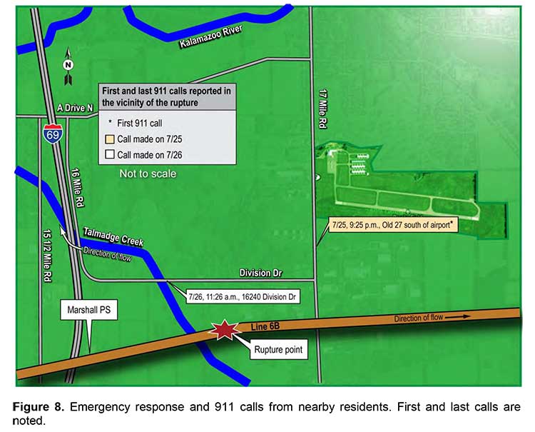
NTSB map of first responders at Kalamazoo spill
A map from the NTSB report showing where the fire department responded to the reports of a gas smell at Marshall, MIchigan, and the location of the actual pipeline break. (NTSB)

The NTSB says the service technician from Michigan Gas Utilities “crossed paths with some of the fire department personnel” but found no evidence of a gas leak.

The fire department personnel departed the scene at 10:54 pm. to return to the station.

The NTSB report says: “ a combustible gas indicator measures percentage of the lower explosive limit, it likely would not detect the oil unless it was very close to the source.”

At 11:33 pm, the area’s 911 system received the first of the seven additional calls when an employee at a business called to report a natural gas odour.

The 911 dispatcher told the caller that the fire department had already responded
to calls in the area, and no more personnel were dispatched.

A map of the incident response by the NTSB shows that the area near the airport where the firefighters responded was actually some distance from the pipeline rupture.

Over the next 14 hours, the NTSB says, 911 received seven more calls reporting strong natural gas or petroleum odours in the same vicinity. “The 911 dispatcher repeatedly informed the callers that the fire department had been dispatched to investigate the reported odours.”

Enbridge had been working on restarting the pipeline all night. In Edmonton, at 10:16 am, the Enbridge control room spoke to the regional manager based in Chicago to send someone to
walk along the pipeline, upstream and downstream of the Marshall pumping station.

According to the NTSB, the Chicago regional manager replied, “I wouldn’t think so. If it’s right at Marshall—you know, it seems like there’s something else going wrong either with the computer or with the instrumentation. …you lost column and things go haywire, right?” He went on to say, “…I’m not convinced. We haven’t had any phone calls. I mean it’s perfect weather out here—if it’s a rupture someone’s going to notice that, you know and smell it.” The Chicago regional manager told shift lead C1 that he was okay with the control centre starting Line 6B again.

At 11:17 am, a caller from a second gas utility, Consumers Energy, called the Enbridge emergency line telling the control room: “I work for Consumers Energy[30] and I’m in Marshall. There’s oil getting into the creek and I believe it’s from your pipeline. I mean there’s a lot. We’re getting like 20 gas leak calls and everything.”

At 11:18 am Enbridge closed the remote valves sealing off the rupture site within a 2.95-mile section. By 11:20 am., the shift lead had called the Chicago regional manager to tell him about the notification. By 11:37 am., another Consumers Energy employee notified 911 about the crude oil leak in a creek near Division Drive.

The Fredonia Township Fire Department was dispatched by the 911 centre shortly after the call. At 11:41 am., the Edmonton control centre received confirmation from an Enbridge crossing coordinator located at the Marshall pipeline maintenance shop confirming the oil on the ground.

The NTSB says:

The 911 operators repeatedly informed the callers that the fire department had been dispatched to investigate the issue, but the 911 operators did not contact the pipeline operator or advise the public of health and safety risks. The 911 operators never dispatched the fire department in response to the subsequent calls even though these calls occurred over several hours, indicating an ongoing problem. The actions of both the first responders and the 911 operators are consistent with a phenomenon known as confirmation bias,128 in which decision makers search for evidence consistent with their theories or decisions, while discounting contradictory evidence. Although there was evidence available to the first responders that something other than natural gas was causing noticeable odours in the Marshall area, they discounted that evidence, largely because it contradicted their own findings of no natural gas in the area. Similarly, the 911 operators, with the evidence from the first responders of no natural gas in the area, discounted subsequent calls regarding the strong odours in the Marshall area. Those calls were inconsistent with their own views that the problem causing the odours was either nonexistent or had been resolved.

The NTSB report then says:

Although Enbridge had provided training to emergency responders in the Marshall area in February 2010, the firefighters’ actions showed a lack of awareness of the nearby crude oil pipeline: they did not search along the Line 6B right-of-way, and they did not call Enbridge. The NTSB concludes that had the firefighters discovered the ruptured segment of Line 6B and called Enbridge, the two start ups of the pipeline might not have occurred and the additional volume might not have been pumped.

The NTSB reviewed Enbridge’s PAP, which was intended to inform the affected public,
emergency officials, and public officials about pipelines and facilitate their ability to recognize
and respond to a pipeline rupture.

The report says:

Although RP 1162 requires operators to communicate with audiences every 1 to 3 years, Enbridge mailed its public awareness materials to all audiences annually. However, even with more frequent mailings, this accident showed that emergency officials and the public lacked actionable knowledge.

The NTSB goes on to say:

Public knowledge of pipeline locations and the hazards associated with the materials
transported is critical for successful recognition and reporting of releases, as well as the safe response to pipeline ruptures. The transportation of hazardous materials by pipeline is unlike hazardous materials transportation by railroad or highway because a pipeline is a permanent fixture. A pipeline presents a unique challenge to awareness because it is often buried. When pipeline releases occur, a properly educated public can be the first to recognize and report the emergency.

A survey quoted by the NTSB says that of those who responded in the United States. only 23 percent of the affected public and 47 percent of emergency officials responded that they were “very well informed” about pipelines in their community.

The NTSB says Enbridge failed to properly conduct and monitor its public awareness program and management’s “review of its PAP was ineffective in identifying and correcting deficiencies. The NTSB further concludes that had Enbridge operated an effective PAP, local emergency response agencies would have been better prepared to respond to early indications of the rupture and may have been able to locate the crude oil and notify Enbridge before control centre staff tried to start the line.”

In May 2011, Enbridge revised its public awareness plan and created a public awareness
committee, but just months later, in July 2011, the US Pipeline and Hazardous Materials Safety Administration conducted an audit of Enbridge’s plans and identified several
deficiencies in the company’s program evaluation and effectiveness reviews and required that
Enbridge correct the deficiencies.

Overall, the report says:

Although Enbridge and PHMSA have taken these actions, the NTSB is concerned that
pipeline operators do not provide emergency officials with specific information about their pipeline systems. The brochures that Enbridge mailed did not identify its pipeline’s location. Instead, the brochures directed the audiences to pipeline markers and to PHMSA’s National Pipeline Mapping System. In the NTSB’s 2011 report of the natural gas transmission pipeline rupture and fire in San Bruno, California, the NTSB made the following safety recommendation to PHMSA:

Require operators of natural gas transmission and distribution pipelines and
hazardous liquid pipelines to provide system-specific information about their
pipeline systems to the emergency response agencies of the communities and
jurisdictions in which those pipelines are located. This information should include
pipe diameter, operating pressure, product transported, and potential impact
radius.

The report concludes:

The NTSB recommends that the International Association of Fire Chiefs  and the National Emergency Number Association  inform their members about the circumstances of the Marshall, Michigan, pipeline accident and urge their members to aggressively and diligently gather from pipeline operators system-specific information about the pipeline systems in their communities and jurisdictions.

In Canada, the National Energy Board, which is responsible for overseeing pipeline operations did inspect the Enbridge control room after the NTSB report.

The NEB, of course, has nothing to do with the 911 system.
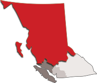
RCMP North District
RCMP map showing the extent of British Columbia’s “North District.” (RCMP)

One question for northern British Columbia is how prepared is the 911 system to handle a major pipeline incident now or in the future. For police and fire, the RCMP communications system must cover all of “North District” from Prince George. (The RCMP did not return a phone call requesting information on 911 training and procedures)

For BC Ambulance the dispatch centre is in Kamloops.

Fire departments in northwest British Columbia, so far, have had minimal training in potential pipeline problems, like the fire department in Michigan, enough to detect and deal with consumer and local industrial natural gas systems. It’s clear that the province of British Columbia, if it is going to promote liquified natural gas as a foundation of a new provincial economy, it must plan and budget for a major upgrade to the 911 system, with a new police, fire and ambulance dispatch centre.
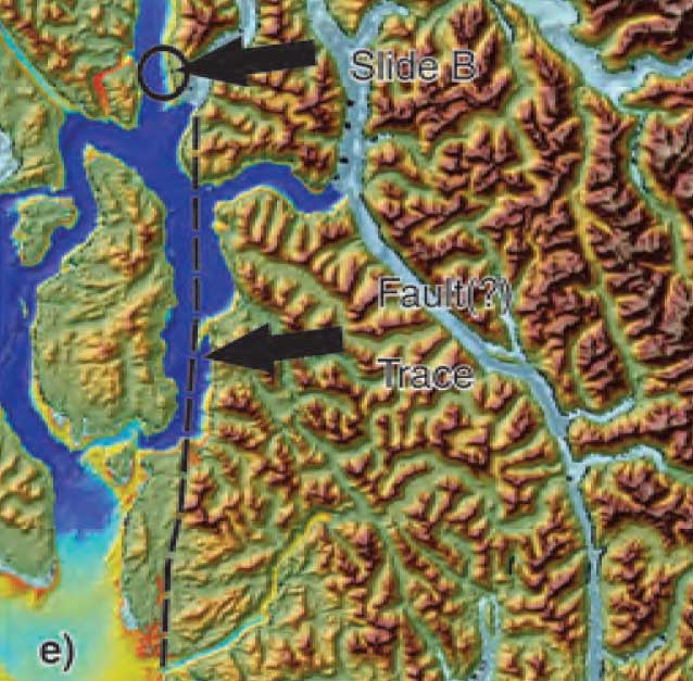


Geological Survey of Canada identifies tsunami hazard, possible fault line on Douglas Channel

Fault zone map Douglas Chanel
A map from the Geological Survey of Canada showing the line of a possible seismic fault on Douglas Channel (Geological Survey of Canada)


Updates with statement from Natural Resources Canada, new filings by Enbridge Northern Gateway and the Attorney General of Canada (in box below)

The Geological Survey of Canada has identified a tsunami hazard and a possible seismic fault in Douglas Channel near Kitimat. A scientific paper by the Geological Survey and the Department of Fisheries and Oceans says there were once two giant landslides on Douglas Channel that triggered major tsunamis and that the landslides were possibly caused by an earthquake on the fault line.

Kitimat is the proposed site of the Enbridge Northern Gateway project and at least three liquified natural gas projects.

If the projects go ahead, hundreds of supertankers with either bitumen or LNG will be sailing in the channel for years to come.

A filing by the Attorney General of Canada with the Northern Gateway Joint Review Panel is asking the JRP for leave to file late written evidence long after the original deadline of December 2011. The Attorney General’s motion was filed on August 17, but went unnoticed until the Kitimat environmental group Douglas Channel Watch brought the matter up with District of Kitimat Council tonight (Sept. 17).

Appended to the Attorney General’s motion is a copy of a scientific paper from the Geological Survey “Submarine slope failures and tsunami hazards in coast British Columbia: Douglas Channel and Kitimat Arm” by Kim W Conway, J.V. Barrie of the Geological Survey and Richard E. Thomson of the Department of Fisheries and Oceans.

The report says the scientists discovered “evidence of large submarine slope failures in southern Douglas Channel.”

It goes on to say: “The failures comprise blocks of bedrock and related materials that appear to have been detached directly from the near shore off Hawkesbury Island.” Hawkesbury Island and many of the other islands in Douglas Channel are built up with material left over from the ice age glaciers and thus are vulnerable to displacement and landslides.

The research identified two slides, one estimated at 32 million cubic metres and a second of 31 million cubic metres. The report goes on to say that the discovery of an “apparently active fault presents the possibility that they may have been triggered by ground motion or surface rupture of the fault during past earthquake events.”

The slope failure landslides are covered with thick layers of mud, and that, the scientists say, could mean that the failures could be ancient, possibly occurring 5.000 to 10,000 years ago. Further research is needed to confirm the date of the giant slides.

What is worrying about the discovery is that fact that there were two recent submarine slope failures on the Kitimat Arm of Douglas Channel. both creating tsunamis. The first slope failure occurred on October 17, 1974, triggering a 2.4 metre tsunami at low tide. Then on April 27, 1975 there was a second slope failure near low tide on the northeast slope of the Kitimat Arm that generated an 8.2 metre tsunami. The 1975 tsunami destroyed the Northland Navigation dock near Kitimat and damaged the Haisla First Nation docks at Kitamaat Village.

The paper says that “Additional geological research is required to better delineate the age of the submarine failures, their triggers, and their mechanisms of emplacement.”

Urgent new research is underway and the filing by the Attorney General says when the Department of Justice requested leave to file late evidence says it anticipates that the further research by DFO is expected to be completed by November 1. The Natural Resources Canada Earth Sciences Sector began a national assessment of submarine slope failures in Canada in late 2011 and completion of the Pacific portion of this assessment is targeted for December of 2012.

The Attorney General’s filing says that DFO is now modelling “potential wave heights and speeds that may have resulted from the two previously unrecognized submarine slope failures in the Douglas Channel.” The model will use high resolution scans of the Douglas Channel seafloor to create the models.

The survey of Douglas Channel in 2010 suggests the possible existence of a fault immediately to the south of the second ancient slide on Hawkesbury Island.

The GSC paper says that evidence for a continuous fault was observed by aligned stream beds and fractures on the south end of Hawkesbury Island, about four kilometers from the site of the second ancient slide. The possible fault then appears to terminate far to the south near Aristazabal Island on the Inside Passage. The Geological Survey says that eleven small earthquakes, all less than magnitude three, have appeared with 20 kilometres of the suspected fault over the past 25 years.

The paper says that the scientists conclude that the slides appear to have left very steep slopes at or near the shoreline that could be susceptible to future failure events.

A large potential slope failure has been identified near one of the ancient slides….

in the absence of additional evidence, the fault must be considered a potential trigger for the submarine failure events….the triggers for the failures have not been defined; however, their proximity to a potentially active fault represents one potential source. The failures probably generated tsunamis during emplacement and conditions exist for similar failures and associated tsunamis to occur along this segment of Douglas Channel in the future.

The scientists say that detailed tsunami modelling is underway to

provide an improved understanding of the generation, propagation, attenuation, and likely coastal inundation of tsunami waves that would have been created by slides… or that could be generated from similar future events. Only through the development and application of this type of tsunami modelling will it be possible to gauge the level of hazard posed by the identified submarine slope failures to shore installations and infrastructure, or to devise ways to effectively mitigate the impacts of future such events.

The filing by the Attorney General offers to bring the scientists to the Joint Review Panel to appear as witnesses sometime during the final hearings.

The filing notes that the current evidence tendered to the JRP by Enbridge, and other parties does demonstrate the potential for marine geohazards and associated tsunami events. Enbridge’s design of the proposed Northern Gateway marine terminal and its operational plans took into consideration the current state of knowledge of geohazards including earthquakes and tsunamis at the time of filing. Enbridge has said it would undertake further geological survey during the detailed design phase for the terminal.

At the time Natural Resources Canada noted that the information provided for the Environmental Review was sufficient at that time, now the Attorney General says:

the geographic scope for potential landslide induced tsunami hazards is now better understood to extend beyond the Kitimat Arm. NRCan and DFO seek by this motion to ensure that this Panel, and the Parties before the Panel, have the most up to date information on geohazards in the Douglas Channel.


Updates: DFO report in October will clarify the tsunamis in Douglas Channel.


Statement from Natural Resources Canada

Natural Resources Canada sent this statement to Northwest Coast Energy News on September 20, 2012.

In reference to the opening paragraph of your September 18th editorial entitled Geological Survey of Canada identifies tsunami hazard: Possible fault line on Douglas Channel, we would like to clarify the following. Although the ancient large submarine slope failures which our scientists have identified may have caused tsunamis, this is not a certainty. It is important to note that Fisheries and Oceans Canada is currently studying this information to model potential wave heights and speeds.

As our report states, only through the development and application of this type of tsunami modelling will it be possible to gauge the level of hazard posed by the identified submarine slope failures to shore installations and infrastructure, or to devise ways to effectively mitigate the impacts of future such events.

 Northern Gateway response filed on August 31, 2012

Enbridge Northern Gateway filed this response to the Attorney General’s motion on August 31.

This motion of the Federal Government Participants requests permission to file late evidence consisting of a report entitled “Submarine Slope Failures and
Tsunami Hazard in Coastal British Columbia: Douglas Channel and Kitimat Arm” regarding tsunami hazard and additional modelling work based on that report.

Northern Gateway does not object to the filing of this late intervenor evidence.
It may be relevant and Northern Gateway accepts that theevidence could not be filed earlier. However, Northern Gateway would like the opportunity to conductits own additional modelling work which it would be prepared to provide to DFO for comment prior to the filing of any modelling work by DFO in this proceeding.

Attorney General response to Enbridge on September 10, 2012.

The Attorney General of Canada responded to Enbridge by saying:

Attorney General responds DFo is prepared to await filing its subseqent modelling work in these proceedings until such time as it has received, reviewed and commented upon additional modelling work as proposed by NGP Inc.

DFO nots howeverand wishes to alert the JRP that the NGP INc proposed may occasion a delay in the filing of the DFO moedling work which is now proposed for filing on or about October 31, 2012. Delivery of DFO comments as requested will depend on when DFO received the NGP Inc modelling work, the time and resources required by DFO to study and provide comments on the NGP modelling work and unforeseen factors which may have an impact upon completion the commentary. As such,

DFO is prepared to file its modeling work on or about October 31, 2012, but subject to any further direction or request by the panel.


Map of Douglas Channel
Geological Survey of Canada map of Douglas Channel showing the area surveyed which discovered the landslides and possible fault line. (Geological Survey of Canada)

;

;

Map of slides at Kitimat
Map from the Geological Survey of Canada showing the landslides on the Kitimat Arm which triggered tsunamis in 1974 and 1975 (Geological Survey of Canada)

;

;

Slide at Hawkesbury Island
Map from the Geological Survey of Canada showing the giant slide on the southern tip of Hawkesbury Island. (Geological Survey of Canada)

;

Hawkesbury Island slide map
Map from the Geological Survey of Canada showing the second giant slide on the coast of Hawkesbury Island on Douglas Channel (Geological Survey of Canada)

Department_of_Justice Notice of Motion of the Attorney General of Canada Seeking to Tender Supplementary Written Evidence (pdf)

Submarine Slope Failures and Tsunami Hazard in Coastal British Columbia Douglas Channel and Kitimat Arm PDF

Kitimat-Stikine Regional District votes to oppose Enbridge Northern Gateway

Map Regional District Kitimat Stikine
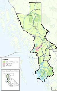
Map showing the Regional District of Kitimat Stikine (RDKS)

The Regional District of Kitimat-Stikine voted on Sept. 14, 2012, to oppose the Enbridge Northern Gateway pipeline. Eight of the twelve Regional District Directors of Kitimat Stikine voted to both to oppose the Northern Gateway project and to support resolutions of the Union of BC Municipalities (UBCM) on the pipeline.

Telegraph Creek director David Brocklebank, who originally proposed the motion, was supported by Dease Lake alternate director Joey Waite, Terrace municipal directors Dave Pernarowski (mayor) and Bruce Bidgood (councillor), Nass director (and regional district chair) Harry Nyce, Hazelton village mayor Alice Maitland, the Hazeltons and  Kispiox/Kitwanga director Linda Pierre and Diana Penner (who was sitting in for the director Doug McLeod) for the rural area around Terrace and Kitimat.

Brocklebank had proposed the motion at the August meeting. It was tabled to allow for the directors who represent the various regions and municipalities time for consultation.
Voting against were Kitimat municipal director Corinne Scott, New Hazelton mayor Gail Lowry, Thornhill’s Ted Ramsey and Stewart municipal director Billie Ann Belcher.

Scott said she was voting against the motion, continuing the Kitimat council’s position that it remain neutral until the report of the Northern Gateway Joint Review panel. Ramsey also said Thornhill wanted to also remain neutral.

Other directors pointed to what they called the politicization of the Joint Review and how they believed it had been influenced by Prime Minister Stephen Harper.

While the District of Kitimat remains neutral, the Skeena Queen Charlotte Regional District, Prince Rupert, Terrace and Smithers have all voted to oppose the Northern Gateway.

Haisla, BC government sign agreement for third LNG facility at Kitimat

Updated with map, agreement details

Map of Haisla Framework Agreement
A map, released by the BC government, shows the area of Crown land covered by the Haisla Framework agreement that could lead to another LNG project in Kitimat. (Govt of BC)

The Haisla Nation and the BC government have signed an agreement that will lead to a third liquified natural gas project near Kitimat.

The “Haisla Framework Agreement” allows for the lease or sale of up to approximately 700 hectares of Crown land near the Douglas Channel, and for the foreshore lease of submerged lands of up to 102 hectares for a berthing facility.


The area is just north of the Haisla Reserve land  at Bish Cove where the KM LNG project will be located, but south of the proposed BC LNG and Enbridge terminals.  It is all undeveloped and unserviced land within the boundaries of the District of Kitimat.

That could mean, if all projects go ahead there the west side of Douglas Channel from Kitimat almost to Jesse Falls would see three, perhaps fourm hydrocarbon facilities and terminals.

The agreement provides the Haisla with the options for up to a 60-year lease or the possibility of purchasing of the land outright.

The agreement also commits both parties to start work on land-use planning for areas around the Douglas Channel, which, the BC government says, has tremendous potential as a marine port.

A news release from the BC government today does not specify the backer of the terminal, While the most obvious candidate could be the  Shell project LNG project (last fall Shell purchased the old Methanex site and the associated marine terminal at Kitimat) there is now media speculation that there could be other players involved, possibly another giant Exxon Mobile.

A news release from the BC government says that the “framework agreement” is a “significant step toward government’s commitment to have three terminals and their connecting pipelines operating by 2020, creating more than 1,400 ongoing jobs and generating an estimated $600 billion in economic activity over 30 years.”

The release says the agreement “provides the structure for a land purchase or lease that will Haisla Framework agreement logoallow the Haisla to partner with industry to develop a liquefied natural gas (LNG) facility and marine export terminal on the west side of the Douglas Channel in the areas around Haisla Reserve #6.”

The release quotes, Ida Chong,  BC Minister of Aboriginal Relations and Reconciliation  as saying:

Our government is working with First Nations like the Haisla to create new jobs and opportunities throughout British Columbia. This agreement builds on our strong partnership with the Haisla Nation, and it is the key to unlocking the vast potential of a whole new natural gas export industry in British Columbia which will provide long-term stability for families and communities.

It also  quotes Ellis Ross, Chief Councillor of the Haisla Nation: –

This agreement allows the Haisla to look at the land on the west side of the Douglas Channel in a different light. This gives the Haisla and associated projects the certainty needed for the LNG proposals and other projects coming forward for our territory. If we are able to do this, the Haisla people will benefit, as will all British Columbians and Canadians.

Ida Chong and Ellis Ross sign agreement
Ida Chong and Ellis Ross sign the Haisla Framework Agreement in Vancouver, Sept.14, 2012 (Govt of BC photo)

The release goes on to say that the agreement signals a closer working relationship between the Haisla and BC in and around the Kitimat and Douglas Channel area. It commits both parties to start work on land-use planning for areas around the Douglas Channel, which has tremendous potential as a marine port. This certainty will allow other development projects in the area to proceed.

The agreement says the Haisla will work independently to find a suitable partner for the development of the land. Details of the lease or sale are expected to be finalized this fall.

Spectra Energy, BG Group propose natural gas pipeline to Prince Rupert, creating fourth NW BC LNG project

Spectra Energy Corp of Houston, Texas, today announced that the company has signed a Project Development Agreement with BG Group PLC, based in the United Kingdom, to jointly develop plans for a natural gas transportation system from northeast B.C. to serve BG Group’s potential liquefied natural gas (LNG) export facility in Prince Rupert.

The BG group signed an agreement last February with the Prince Rupert Port Authority  for a feasibility study to develop an LNG terminal at the port.

Spectra Energy BC project map
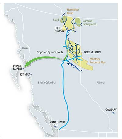
A map released by Spectra Energy shows the proposed pipeline project from the shale gas fields of northeastern BC to Prince Rupert (Spectra Energy)


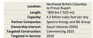
A release from Spectra Energy and BG Groupsays each company will initially own a 50 per cent interest in the proposed transportation project. Spectra Energy will be responsible for construction and operation and BG Group has agreed to contract for all of the proposed capacity.

The approximately 850-kilometre, large diameter natural gas transportation system will begin in northeast B.C. and end at BG Group’s potential LNG export facility in Prince Rupert.

A fact sheet released by Spectra says the project would provide 50 to 60 permanent jobs on completion and about 4,000 jobs during construction.

BC Group logoThe Spectra BG project will be the fourth using BC’s strategic position on the Great Circle Route to Asia to export liquified natural gas. TransCanada has signed a deal with Shell for a pipeline, Coastal GasLink, that would initially carry up to 1.7-billion cubic feet a day of gas to the Shell Canada project at Kitimat The Pacific Trails pipeline, could carry more than 1-billion cubic feet a day to the KM LNG partners ship where Apache, EOG and Encana are building a terminal at Bish Cove, south of Kitimat. The fourth project, BC LNG, would use either existing pipelines or share one of the proposed Kitimat pipelines to produce LNG for customers at a barge-based floating terminal at what is sometimes called North Cove, between the KM LNG project at Bish Cove and the proposed Enbridge Northern Gateway project which would be close to the Rio Tinto Alcan smelter.

Spectra Energy LogoThe Spectra release says the new transportation system will be capable of transporting up to 4.2 billion cubic feet per day of natural gas. The project will connect with the Spectra Energy facility at Fort St. John, the centre of the still growing shale gas production and exploration in the northeastern BC.

Greg Ebel, president and chief executive officer, Spectra Energy says in the release:

We are excited to be partnering with BG Group, a recognized world leader in natural gas and more specifically, LNG. This project offers B.C. a unique opportunity to access new markets, strengthen its energy infrastructure, engage stakeholders in economic growth and job creation, and ultimately secure the province’s position as a competitive energy leader.

Furthermore, today’s announcement initiates our next wave of investment opportunity in B.C.  We are ideally positioned to create further value for our investors by leveraging surplus B.C. natural gas supplies and facilitating its export to high-demand markets in Asia. This, in turn, will provide multiple opportunities for further investment in our gathering and processing facilities in the province.

Doug Bloom president of Spectra Energy Transmission West adds in the release:

For more than half a century, Spectra Energy has been a part of communities in B.C. This project will build on our expertise and track record of delivering natural gas responsibly, listening to the needs of Aboriginal and local communities, and protecting the environment, as we help deliver on B.C.’s energy potential.
Working together with affected stakeholders and based on preliminary assessments of environmental, historical, cultural and constructability factors, early conceptual routes have been developed. Spectra Energy and BG Group will continue engaging with interested and affected stakeholders, including Aboriginal and local communities, environmental organizations and regulatory agencies, to further refine the project route.

Spectra Energy Fact Box
Fact box from Spectra Energy on the proposed pipeline to Prince Rupert (Spectra)

As is now common with proposed energy projects for northwestern British Colulmbia, Spectra  has set up a website for consultations Energy for BC.

Spectra says: “The new outreach initiative is designed to engage with stakeholders on the jobs, revenues and environmental benefits that natural gas can create in British Columbia.”
Spectra also makes the usual commitment to “spend the next several years closely conferring with stakeholders and working through the permitting process for the proposed transportation system.”

Spectra Energy Project Fact Sheet
  PDF

What is it about Douglas Channel islands? Now a US agency has added a “Douglas Island”

US FERC Map of LNG terminals in North America
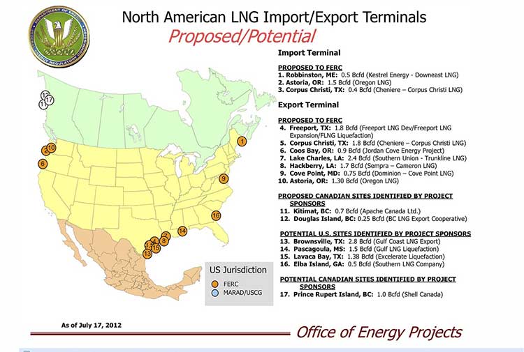
Map from the United States Federal Energy Regulatory Commission showing LNG export terminal projects in North America (FERC)

What is it about the islands in Douglas Channel? First, Enbridge gets in to a lot of hot water, so to speak, for erasing the islands in Douglas Channel in an animation promoting the Northern Gateway Pipeline.  See for example The Vancouver Sun on back on Aug. 16, 2012, when it picked up a story from the Times Colonist – Enbridge map sinks islands, angers critics.   The controversial video segment showed Douglas Channel wide open for navigation, rather than marked with about one thousand square kilometres of mountainous islands. Map of Douglas Channel Islands from Leadnow.ca This map, created by the Leadnow.ca and  Sumofus.org websites was widely used by the media to show the difference.  Enbridge later amended its video with a disclaimer that it is “broadly representational.” A video by Shortt and Epic Productions “This is Not An Enbridge animation” showing the beauty of northwestern BC quickly went viral.

As this was happening, the United States government Federal Energy Regulatory Commission issued a map that shows Liquified Natural Gas import and export terminals across North America, a map that adds an island to the Channel–“Douglas Island.”

In fact, the map manages to get a lot about Canadian LNG projects wrong. It locates the BC LNG project on the non-existent Douglas Island. The company’s name Douglas Channel Energy Partnership actually gives the proper location this way

 south of the Moon Bay Marina, within the District of Kitimat and the asserted traditional territory of the Haisla Nation. The site is approximately 10 km southwest of Kitimat and 7 km north of Bees Cove Indian Reserve 6 (Bish Cove)

The small cove where BCLNG will put its barges to create the LNG is often locally called North Cove.

The FERC map also misplaces the Shell LNG project, now known as LNGCanada, in Prince Rupert, even though Shell confirmed the Kitimat location on May 15, 2012. It also calls it Prince Rupert Island, although the town of Prince Rupert is actually located on Kaien Island.

The map does apparently get the KM LNG project somewhat correct, attributing it to Apache Canada, but leaving off Apache’s partners, Encana and EOG.

The map recently also appeared on the website of Oregon Public Broadcasting in an article Five Keys To The Pacific Northwest’s Natural Gas Export Debate by reporter Amelia Templeton, which outlines the growing controversy over the plans to export US LNG through Coos Bay, Oregon via the Jordan Cove Project.

It appears that in Oregon, the Coos Bay LNG project is becoming as controversial as the Northern Gateway project is in Canada.

The issues outlined by Templeton include the threat of expropriation (called “eminent domain” in the US and also a key issue in the debate over the Keystone XL pipeline on the plains).  There are arguments on jobs versus the environment, especially the perceived threat to wild rivers and salmon spawning grounds. Finally one issue that is lower on the agenda in northwestern BC but a big worry in Oregon, the potential for a devastating earthquake along the Cascadia fault.

During the NEB hearings on the KM LNG (Apache/EOG/Encana) project in June, 2011, many of the  “expert” witnesses urged that that first Kitimat project go ahead quickly because of perceived competition from Oregon.

Unlike in Oregon, LNG projects are generally perceived positively in the northwest and all three are going ahead, although not as quickly as originally planned due to market volatility among prime potential customers in Asia.


How “On the Waterfront” could decide the fate of Enbridge’s Kitimat terminal

There’s one question about the Enbridge Northern Gateway project that many people ask and few can answer: Who is responsible for the port of Kitimat? Who would be liable should there be a disaster in the port? Nobody really knows.

Unlike many harbours in Canada, the port of Kitimat is “private,” although as the District of Kitimat says, “Transport Canada and other federal agencies continue to regulate navigation, security and environmental safety.” Kitimat has promoted that private status as an economic advantage.

If there’s a dispute, the question of responsibility and liability would probably end up in the Supreme Court of Canada, with the justices sorting out a historic puzzle. Or perhaps that historical puzzle could mean that the future of the port of Kitimat might be decided by the next B.C. provincial election.

Most of the other harbours in Canada are the responsibility of Ports Canada, a branch of Transport Canada or run by (usually not-for-profit) semi-public port corporations or local harbour commissions.

To find out why Kitimat is one of the few private ports in Canada, the first thing to do is watch Eliza Kazan and Bud Schulberg’s classic 1954 multiple Oscar winning movie, On the Waterfront, starring Marlon Brando, about how the mob ran the New York docks.

What has On the Waterfront got to do with Kitimat? It goes back to when the then Aluminum Company of Canada/Alcan (now Rio Tinto Alcan) was planning the Kitimat project; much of that work was done in New York both by employees and consultants. It was in 1949, that Malcolm Johnson, a New York Sun reporter, wrote a Pulitzer Prize winning series of investigative reports called “Crime on the Waterfront,” exposing corruption and Mafia involvement with the docks and the longshoremans’ union. The movie was based, in part, on that investigative series.

So in its planning, Alcan was determined that the longshore unions would not be involved in running the docks in Kitimat. The publicly stated reason has always been that Alcan wanted a seamless 24/7 operation that would be integrated with the aluminum smelter. Alcan would sign a collective agreement with the United Steelworkers that covered both the smelter and the docks. (CAW 2301 now represents most of the workers at the Kitimat smelter.)

When the Kitimat project was being finalized in 1949 and 1950 at the height of the Cold War, aluminum was a strategic commodity, security was high on the agenda, and it was not just the Soviet bloc but the mob as well that worried the authorities.

Add two factors. First, in 1949 the province of British Columbia was anxious to promote what would today be called a “mega-project.” Second, in the post-war era when corporations were relatively enlightened compared to today, Alcan was determined not to create the traditional “company town.”

To promote private-sector development of both hydro-electricity and aluminum, B.C. signed a rather loosely worded agreement with Alcan, noting that the project was going on “without investment by or risk to the government.” That agreement was implemented by the Legislative Assembly of B.C. by an equally wide open Industrial Development Act. One aim of both was try to ensure that future “socialists” would not expropriate the project.

Industrial township

With the province handing over the Crown land at the head of Douglas Channel at a very nominal price to Alcan, next came the creation of the District of Kitimat. With the town under construction, with few buildings and a small population, under normal B.C. practice, the area would be “unincorporated” and would not have a municipal government. But Alcan and the province came up with a new concept, which they called “an industrial township,” which would allow a municipal government to be established in anticipation of future growth.

The act that established the District of Kitimat put the boundaries outside the land owned by Alcan (excluding land reserved for the Haisla Nation).

Alcan began selling off the land in the planned areas of the town and other land it didn’t need. Individuals bought houses and businesses bought the land for their own use. Alcan retained ownership of the harbour and estuary lands and the small “Hospital Beach.”

The District of Kitimat has some legal responsibility for “wharfs” at the port of Kitimat. At council meetings, the environmental group, Douglas Channel Watch, has raised the question of the district’s responsibility and liability in case of an Enbridge incident but there’s been no definitive response from district staff. There is no municipal harbour commission as there is in other jurisdictions.

Up until recently, it was a convenient arrangement for everyone involved. Alcan, Eurocan and Methanex ran their dock operations without any interference, beyond standard Transport Canada oversight.

Things began to change in 2007, when the Rio Tinto Group bought Alcan, creating Rio Tinto Alcan. A couple of years ago, a senior staff source in the Canadian Auto Workers explained it to me it this way. “Alcan was a big corporation, but Alcan was a corporation with a big stake in Canada. As a union, we could do business with them. Rio Tinto is a transnational corporation with businesses in lots of countries but no stake in any of them. So it’s a lot harder now.”

With the Rio Tinto acquisition of Alcan, things tightened up in Kitimat. Negotiations between the District and RTA for the District to obtain more land stalled. Access to the estuary and other RTA lands that had been somewhat open under Alcan became more restrictive. In 2010, the Eurocan paper mill shut down along with its dock. In 2011, Rio Tinto bought the dock from West Fraser, owner of Eurocan. The Kitimat community noted that when the dock was repainted, it said just “Rio Tinto.” not “Rio Tinto Alcan” and that led to lots of gossip and wondering about what the Rio Tinto Group really plans for Kitimat. Last fall, Shell Canada purchased the former Methanex dock for part of its liquified natural gas operations.

With the Enbridge Northern Gateway project, the BC LNG project at North Cove and the KM LNG project at Bish Cove all along the shore of Douglas Channel and within the boundaries of the District of Kitimat which extends as far south as Jesse Lake, the question that has to be asked is, what happens now? If the Enbridge project is built, it will start just beyond the boundaries of the land owned by Rio Tinto Alcan.

That old arrangement between Alcan and the District of Kitimat is facing many new challenges.

The district once had a harbour master, but the position was eliminated because he had nothing to do. Alcan owned its docks, Alcan managed the docks and Alcan union employees worked on the docks. Later came the Eurocan (now owned by Rio Tinto) and Methanex (now owned by Shell) docks, again owned and operated by private corporations.

The District of Kitimat, nominally in charge, was content to sit back and collect taxes.

With the Enbridge Northern Gateway project, the B.C. LNG project at North Cove and the KM LNG project at Bish Cove all along the shore of Douglas Channel and within the boundaries of the District of Kitimat, the question that has to be asked is, what happens now? If the Enbridge project is built, it will start just beyond the boundaries of the land owned by Rio Tinto Alcan.

In Canada, ports and harbours are normally under federal jurisdiction and Transport Canada has oversight. But Alcan’s “private port” and the District of Kitimat were created by acts passed by the B.C. government.

The original agreement between the province and Alcan mentions an “aluminum plant” and “low-cost electrical power,” it doesn’t mention bitumen or liquified natural gas. Those provincial acts do not cover bitumen, supertankers and liquified natural gas.

B.C. Opposition Leader Adrian Dix has made it clear that his New Democratic Party opposes the Northern Gateway project. The federal government has said the province can’t really do anything to stop Enbridge Northern Gateway once Stephen Harper has decided that the pipeline project is in the national interest.

At this moment, Dix is a “contender” for the premiership, with Christy Clark and the B.C. Liberals dropping in the polls and with key members of her government deciding not to run in the election next spring.

So, if, as expected, Adrian Dix becomes the next B.C. premier, he has one very strong hand to play. Any act can, with proper legal advice, be amended by the B.C. legislature. That means the “socialists” so feared by Alcan and the premier of the day, Byron “Boss” Johnson, could alter the 1949 law. That in turn may upset the decades-old arrangement that created the private port which Enbridge is banking on.

Water, not oil, is the hot issue this summer in Kitimat

Kitimat's "Hospital Beach" on March 17, 2012, with the construction at the Rio Tinto Alcan plant in the background, before the area was closed to the public. (Robin Rowland) (Robin Rowland)
Kitimat’s “Hospital Beach” on March 17, 2012, with the construction at the Rio Tinto Alcan plant in the background, before the area was closed to the public. (Robin Rowland)


The hottest issue in Kitimat this summer is water, not oil. For us, this summer can be summed up by saying: “Water, water everywhere, but you can’t get there from here.”

Even with David Black’s proposal for an oil refinery on a hill 25 kilometres north of Kitimat, residents here know that the Enbridge Northern Gateway debate has gone on for years and will go on for many years to come.

As environmentalists worldwide celebrate the beauty of Douglas Channel, and decry the dangers that tanker traffic could pose to the channel, many people in Kitimat are cut off from the waterfront.

At the District of Kitimat Council meeting on August 7, Coun. Mario Feldhoff introduced a motion calling for a study in an effort to find ways to launch kayaks into the ocean. Yes that’s right, according to members of council, you can’t even drop a kayak into the waters of Douglas Channel unless you pay the kind marina a launch fee usually charged for larger fishing boats. Kitimat is down to only one expensive boat launch.

In 2010, there were three marinas in Kitimat: one privately operated at a place called Moon Bay, a large marina owned by the Kitimat Stikine Regional District at MK Bay and a small marina at Minette Bay, also the site of a log export operation. There was also a boat launch on land known as “Alcan beach” or “Hospital Beach” on property owned by Rio Tinto Alcan (RTA) near the aluminum smelter. Hospital Beach is the only beach in Kitimat (named because it is on the site of the town’s original hospital in the 1950s). Moon Bay was located on land owned by RTA, and in April 2010, it ordered the marina shut down.

According to RTA spokesperson Colleen Nyce, that was largely due to concerns about how the marina was being operated.

Some people who moored their boats at Moon Bay moved to MK Bay (if there was room). Others hauled their boats out of the water and parked them in their driveways. In the ensuing two years, there have been increasing stories about mismanagement at MK Bay and complaints about moorageand launching fees that are much higher than elsewhere in the province.

This spring, citing construction at the smelter, RTA closed public access to Hospital Beach for picnics, kids’ play and just looking at the water. That meant the boat launch was also off-limits. RTA spokesperson Nyce said:

The Rio Tinto Alcan site is now a full fledged construction zone with constant vehicular and heavy duty construction traffic. To that end, and as Rio Tinto Alcan representatives have always said, during construction we will take necessary steps to eliminate potential hazards to the general public on our road including access to Hospital Beach. Therefore, Hospital Beach will be closed to the public until construction is complete or until we believe it is more safe for public access.

Before access was closed, if a Kitimat resident was driving to Hospital Beach, they pass what was once a rough logging road that snaked its way along the shores of Douglas Channel toward Bish Cove. Now Bish Cove is the site of the Kitimat LNG project terminal. As part of the construction process, KM LNG upgraded the road. However, as the pace of construction increases KM LNG is now limiting access to the road and its views of the channel.

Why is there no access to the waterfront, or for that matter to the magnificent Kitimat River estuary?

It goes back to 1950 when the province of B.C., in a loosely worded agreement with what was then Alcan and in an equally non-specific Industrial Development Act, handed over the land where Kitimat is now to the company.

That included almost all the waterfront and the estuary. On the estuary, there is one small area of land that is a reserve for the Haisla Nation and one small area not in RTA domain owned by the District of Kitimat — but there is no right of way through a potential private development. Over the years, and especially since Rio Tinto took over Alcan, there have been more and more restrictions placed on access to Kitimat’s waterfront.

Restricted access has become such an important issue that it came up during the National Energy Board hearings on the Kitimat LNG project and was part of the NEB ruling granting KM LNG its export licence. Access to Kitimat’s waterfront is also a factor in the Enbridge Northern Gateway project, although that part is lost in all the bigger issues.

The fact that you can’t get to the waterfront and the estuary are a problem not only for community recreation; the inability for a resident or visitor to launch a kayak or small boat into the channel, much less larger fishing or recreational vessels, has put the brake on expansion of Kitimat’s already lucrative fishing, guiding and boating services.

There is already a lot of skepticism in Kitimat — due to the boom and bust of the industrial cycle — about all those promises of jobs and prosperity from industrial development. Restricted access to the ocean means that despite the growing number of jobs in Kitimat, corporate policy makes it hard to enjoy the benefits of living on the Douglas Channel.

It is the kind of externality that is always ignored by economists and is totally irrelevant to those business writers who claim to be experts in Kitimat but who have never been within 1,000 kilometres of the town.

You look out your window at the mountains and ocean of Douglas Channel and ask why can’t the residents and tourists go to the beach? That could be a key issue in the Enbridge Northern Gateway debate.

Douglas Channel in Black and White

[photoshelter-gallery g_id=”G000034M5Z2_lI4Q” g_name=”Douglas-Channel-in-black-and-white” f_show_caption=”t” img_title=”iptch” pho_credit=”iptc” f_link=”f” f_send_to_friend_btn=”t” f_fullscreen=”t” f_topbar=”t” f_bbar=”t” f_htmllinks=”t” f_mtrx=”t” fsvis=”f” width=”615″ height=”461″ f_constrain=”t” bgcolor=”#AAAAAA” btype=”new” bcolor=”#CCCCCC” crop=”f” trans=”xfade” tbs=”10000″ f_ap=”t” bgtrans=”f” linkdest=”c” twoup=”f” f_bbarbig=”” f_enable_embed_btn=”f” f_show_watermark=”f” f_show_slidenum=”f” f_smooth=”f” f_up=”f” target=”_self” wmds=”llQ6QNgpeC.p1Ucz7U.Y5p9TTphsaUCWglrsuG3u3BJwmfV6PzC2SqyK_HnEz4rFhVjU4A–” ]

Photogallery. For full screen mode with captions, click on the box to the right of the bottom menu bar.

The long, magnificent fjord known as Douglas Channel was carved by a glacier thousands of years ago, some of the islands are rock uplifted by tectonic forces, others piled up by retreating glaciers.

So far, since I returned to Kitimat, I have had few chances to “go down the Channel,”  as the people of Kitimat say.

Of course, when I do go,  I always have a camera with me, even in the roughest weather–and the Channel can be rough most of the year.

It is in these waters that the energy industry, both the Enbridge Northern Gateway and the Liquefied Natural Gas projects want to use supertankers to send their products to markets in Asia. Many of the photographers who come to Douglas Channel in high summer choose to capture the brilliant colours of ocean, forest and mountain, as I have on several assignments.

For this gallery, I have chosen to use black and white to show the stark beauty of the mountains, the often menacing seas and the clouds, ever changing, as the westerly winds from the Pacific drive those clouds against the mountains.

Images from this gallery are available for purchase for personal, editorial and commercial  use on Photoshelter. Simply click on the image above.

Romney endorses Harper’s environmental fast track policy–if oil goes to the United States

Mitt Romney, the Republican candidate for president of the United States today issued his “white paper” on energy policy. It calls for an integrated energy market with Canada, the United States and Mexico. Romney also endorses Prime Minister Stephen Harper’s environmental fast track “one project one review” policy.

The PDF version of The Romney Plan for a Stronger Middle Class Energy Independence is posted on his campaign site.

In the Executive Summary Romney says:

A crucial component of Mitt Romney’s Plan for a Stronger Middle Class is to dramatically increase domestic energy production and partner closely with Canada and Mexico to achieve North American energy independence by 2020. While resident Obama has described his own energy policy as a “hodgepodge,” sent billions of taxpayer dollars to green energy projects run by political cronies, rejected the Keystone XL Pipeline as not in “the national interest,” and sought repeatedly to stall development of America’s domestic resources, Romney’s path forward would establish America as an energy superpower in the 21st century.

It’s key recommendations are:

• Approve the Keystone XL pipeline;

• Establish a regional agreement to facilitate cross-border energy investment,
infrastructure, and sales;

• Promote and expand regulatory cooperation between governments to encourage
responsible energy production, including the creation of a forum for sharing best
practices and technologies; and

• Institute fast-track regulatory approval processes for cross-border pipelines and other infrastructure.

While the white paper is supposed to be the foundation of Republican energy policy, it is itself a “hodgepdge,” mostly a cut and paste job of various reports in the US and Canadian media. While the paper does cite those many sources, it is the kind of compiliation that would get a university freshman a fail, for lack of original content. It also get the name of Canada’s finance minister wrong in one reference, calling him correctly Jim Flaherty in the headline but “Jay Flaherty” in the story credit.

Romney’s paper also seems to be worried that the fact from the prime minister, many economists and policy analysts are saying that it is imperative that Canada diversify its market away from the United States.

Some key highlights of Romney’s white paper of quotes includes:

Obama’s Rejection Of Keystone Will Force Canada To Ship Its Vast Supplies Of Oil To China. “Ronald Liepert, the energy minister in Alberta, said that while Canada would prefer to sell its oil to the United States, ‘this commodity will go someplace.’ In particular, he said, China is already a major consumer of other Canadian natural resources and a small investor in the oil sands. ‘I can predict confidently that at some point China will take every drop of oil Canada can produce.’” (Ian Austen, “Oil Sands Project in Canada Will Go On If Pipeline Is Blocked,” The New York Times, 6/6/11)

Romney then quotes SunMedia:

Canadian PM Harper: “Look, the very fact that a ‘no’ could even be said underscores to our country that we must diversify our energy export markets…We cannot be, as a country, in a situation where our one and, in many cases, only energy partner could say no to our energy products. We just cannot be in that position.” (Bryn Weese, “Harper Determined To Get Canadian Oil To Asia,” Sun News, 4/3/12)

So while Romney wants to approve the Keystone XL pipeline, there is no mention of the Northern Gateway project, but it is clear they don’t want bitumen oil going outside of the continent.

However, the Republicans seem to like quoting Harper’s fast track approach which has caused an uproar here in Canada, quoting the Wall Street Journal:

Compare The Canadian Approach: “One Project, One Review.” “The budget also treats Canada’s energy resources as national assets to be exploited—with as few delays as possible. Thus the budget proposes to eliminate overlapping federal and provincial environmental reviews for major projects. It proposes firm review timelines, including for projects that are already underway, such as the Northern Gateway pipeline from northern Alberta to the Pacific coast. Mr. Flaherty’s catch phrase is ‘one project, one review.’” (Editorial, “Canada Beats America,” The Wall Street Journal, 4/3/12)

and also appearing to endorse downloading to the provinces (or in the case of the US, the states), while warning Americans about Finance Minister Jim Flaherty’s statement in the Commons about diversifying Canada’s markets.

Compare The Canadian Approach: “Respect Provincial Jurisdiction … Streamline The
Review Process.” CANADIAN FINANCE MINISTER JIM FLAHERTY: “Canada’s resource industries offer huge potential to create even more jobs and growth, now and over the next generation. This potential exists in every region of the country–natural gas in British Columbia, oil and minerals on the Prairies, the Ring of Fire in Ontario, Plan Nord in Quebec, hydro power in Atlantic Canada, and mining in Canada’s North. Recently it has become clear that we must develop new export markets for
Canada’s energy and natural resources, to reduce our dependence on markets in the United States.
The booming economies of the Asia- Pacific region are a huge and increasing source of demand, but Canada is not the only country to which they can turn. If we fail to act now, this historic window of opportunity will close. We will implement responsible resource development and smart regulation for major economic projects, respecting provincial jurisdiction and maintaining the highest standards of environmental protection. We will streamline the review process for such projects, according to the following principle: one project, one review, completed in a clearly defined time period. We will ensure that Canada has the infrastructure we need to move our exports to new markets.” (Canadian Finance Minister Jay Flaherty, The House Of Commons, Remarks, 3/29/12)

One has to wonder if Mitt Romney’s other policies are also cut and paste jobs and, if elected, how often he will be calling Stephen Harper for advice.