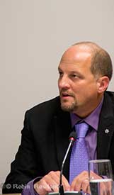
Councillor Phil Germuth questions Northern Gateway officials about their plans for leak detection, Feb. 17, 2014 (Robin Rowland/Northwest Coast Energy News)
Enbridge Northern Gateway officials are loath (to put it mildly) to speak to the media but sometimes they let things slip. Earlier this summer, at a social event, I heard an Enbridge official (probably inadvertently) reveal that when the company’s engineers came before District of Kitimat Council earlier this year they were surprised and somewhat unprepared to fully answer the detailed technical questions from Councillor Phil Germuth on pipeline leak detection.
The results of the municipal election in Kitimat, and elsewhere across BC show one clear message; voters do want industrial development in their communities, but not at any price. Communities are no longer prepared to be drive by casualties for giant corporations on their road to shareholder value.
The federal Conservatives and the BC provincial Liberals have, up until now, successfully used the “all or nothing thinking” argument. That argument is: You either accept everything a project proponent wants, whether in the mining or energy sectors, or you are against all development. Psychologists will tell you that “all or nothing thinking” only leads to personal defeat and depression. In politics, especially in an age of attack ads and polarization, the all or nothing thinking strategy often works. Saturday’s results, however, show that at least at the municipal level, the all or nothing argument is a political loser. Where “all politics is local” the majority of people are aware of the details of the issues and reject black and white thinking.
Northern Gateway’s Ray Philpenko gives a presentation on pipeline leak detection to Kitimat Council, Feb. 17. 2014. (Robin Rowland/Northwest Coast Energy News)
The Enbridge official went on to say that for their company observers, Germuth’s questions were a “what the…..” moment. As in “what the …..” is this small town councillor doing challenging our expertise?
But then Enbridge (and the other pipeline companies) have always tended to under estimate the intelligence of people who live along the route of proposed projects whether in British Columbia or elsewhere in North America, preferring to either ignore or demonize opponents and to lump skeptics into the opponent camp. The Northern Gateway Joint Review Panel also lost credibility when it accepted most of Northern Gateway’s arguments at face value while saying “what the ……” do these amateurs living along the pipeline route know?
Pro Development
“I am pro-development,” Germuth proclaimed to reporters in Kitimat on Saturday night after his landslide victory in his campaign for mayor.
On the issue of leak detection, over a period of two years, Germuth did his homework, checked his facts and looked for the best technology on leak detection for pipelines. That’s a crucial issue here where pipelines cross hundreds of kilometres of wilderness and there just aren’t the people around to notice something is amiss (as the people of Marshall, Michigan wondered at the time of the Line 6B breach back in 2010). Enbridge should have been prepared; Germuth first raised public questions about leak detection at a public forum in August 2012. In February 2014, after another eighteen months of research, he was ready to cross-examine, as much as possible under council rules of procedure. Enbridge fumbled the answers.
So that’s the kind of politician that will be mayor of Kitimat for the next four years, technically astute, pro-development but skeptical of corporate promises and determined to protect the environment.
Across the province, despite obstacles to opposition set up by the federal and provincial governments, proponents are now in for a tougher time (something that some companies will actually welcome since it raises the standards for development).
We see similar results in key votes in British Columbia. In Vancouver, Gregor Roberston, despite some problems with policies in some neighborhoods, won re-election on his green and anti-tankers platform. In Burnaby, Derek Corrigan handily won re-election and has already repeated his determination to stop the twinning of the Kinder Morgan pipeline through his town. In Prince Rupert, Lee Brain defeated incumbent Jack Musselman. Brain, who has on the ground experience working at an oil refinery in India, supports LNG development but has also been vocal in his opposition to Northern Gateway.
The new mayor in Terrace Carol Leclerc is an unknown factor, a former candidate for the BC Liberal party, who campaigned mainly on local issues. In the Terrace debate she refused to be pinned down on whether or not she supported Northern Gateway, saying, “Do I see Enbridge going ahead? Not a hope,” but later adding, “I’d go with a pipeline before I’d go with a rail car.”
Kitimat election signs. (Robin Rowland/Northwest Coast Energy News)
Plebiscite confirmed
Kitimat’s mayor and council elections also confirm that Northern Gateway plebiscite vote last April. Kitimat wants industrial development but not at the price of the community and the environment. The unofficial pro-development slate lost. A last minute attempt to smear Germuth on social media was quickly shot down by people from all sides of the Kitimat debate. Smears don’t usually work in small towns where everyone knows everyone.
Larry Walker, an environmentalist with a track record in municipal politics as an alderman in Spruce Grove, Alberta, won a seat. Together with Rob Goffinet and Germuth, that is three solid votes for the environment. The other new councillor is Claire Rattee who will be one to watch. Will the rookie be the swing vote as Corinne Scott was?
Mario Feldhoff who came to third to Goffinet in the overall vote (Edwin Empinado was second) is a solid councillor with a strong reputation for doing his homework and attention to detail and the unofficial leader of the side more inclined to support development. Feldhoff got votes from all sides in the community.
During the debates, Feldhoff repeated his position that he supports David Black’s Kitimat Clean refinery. But as an accountant, Feldhoff will have to realize that Black’s plan, which many commentators say was economically doubtful with oil at $110 a barrel, is impractical with oil at $78 a barrel for Brent Crude and expected to fall farther. Any idea of a refinery bringing jobs to Kitimat will have to be put on hold for now.
LNG projects are also dependent on the volatility and uncertainty in the marketplace. The companies involved keep postponing the all important Final Investment Decisions.
There are also Kitimat specific issues to deal with. What happens to the airshed, now and in the future? Access to the ocean remains a big issue. RTA’s gift of land on Minette Bay is a step in the right direction, but while estuary land is great for camping, canoeing and nature lovers, it is not a beach. There is still the need for a well-managed marina and boat launch that will be open and available to everyone in the valley.
Germuth will have to unite a sometimes contentious council to ensure Kitimat’s future prosperity without giving up the skepticism necessary when corporations sit on a table facing council on a Monday night, trying to sell their latest projects. That all means that Germuth has his job cut out for him over the next four years.
On Monday, October 20, 2014, the Minister of Fisheries and Oceans, Gail Shea, stood in the House of Commons during Question Period and proved she is not up for the job.
Answering questions from Opposition MPs about the incident of the Russian container ship, Simushir, which drifted dangerously close to the coast of Haida Gwaii, Shea got up and read a prepared script, a script with answers which ignored centuries of the laws and custom of the sea, as well as Canada’s own laws and treaty obligations, answers probably written by what are now known as “the kids in short pants” in the Prime Minister’s Office.
There was a time in this country when some ministers of the Crown took their responsibilities seriously. That idea that has decayed over the years and now has been gutted by the adminstration of Stephen Harper. As Ottawa pundits have noted recently, only a small handful of cabinet ministers in the Harper government have any real responsibility and only those are permitted to answer questions by themselves in the Commons. According to most Ottawa insiders, the less important ministers, like Shea, are basically told what to do by the prime minister’s office.
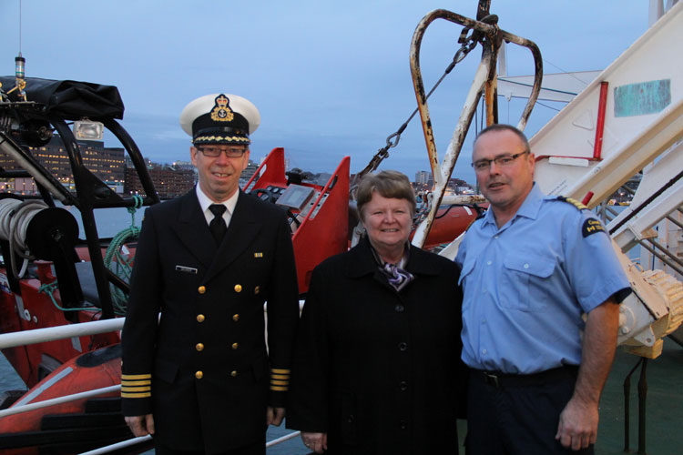
Gail Shea, Minister of Fisheries and Oceans, visited the Canadian Coast Guard Ship Leonard J. Cowley on Friday, December 6, 2013, to examine the fast rescue craft launching mechanism for offshore fishery patrols with Regional Director, Fleet, Stephen Decker and Captain Kerry Evely, Commanding Officer. The Cowley conducts fisheries patrols and monitors fishing activities under Canada’s commitment to the Northwest Atlantic Fisheries Organization. (DFO)
If the House of Commons under Harper could fall any lower, Shea’s attitude (or more likely the PMO’s attitude) on ship and coastal safety takes the Commons and ministerial responsibility to a new low—the bottom of the sea.
Nathan Cullen, NDP MP for Skeena Bulkley Valley, who represents Haida Gwaii first asked. “Mr. Speaker, on Friday, a Russian ship carrying more than 500 million litres of bunker fuel lost all power just off the coast of Haida Gwaii.The Canadian Coast Guard vessel, the Gordon Reid, was hundreds of kilometres away, and it took almost 20 hours for it to reach the drifting ship. Thankfully, favourable winds helped keep the ship from running aground, and a private American tugboat eventually towed it to shore. Is the minister comfortable with a marine safety plan that is based on a U.S. tugboat and blind luck in order to keep B.C.’s coast safe?”
Shea responded.
“Mr. Speaker, luck had nothing to do with the situation. The Russian ship lost power outside Canadian waters in very rough weather. The private sector provides towing service to the marine industry. We are grateful that the Canadian Coast Guard was able to keep the situation under control in very difficult conditions until the tug arrived from Prince Rupert.”
Cullen tried again:
“Mr. Speaker, if the government really wanted to show its gratitude to the Canadian Coast Guard maybe it would not have cut $20 million and 300 personnel from its budget. Even after the Gordon Reid arrived, its tow cable snapped three times. The Russian ship was only about a third as big as the huge supertankers that northern gateway would bring to the very same waters off the west coast. How can Conservatives, especially B.C. Conservatives, back their government’s plan to put hundreds of oil supertankers off the B.C. coast when we do not even have the capacity to protect ourselves right now?”
Shea replied: “Mr. Speaker, this Russian ship lost power outside of Canadian waters. The Canadian Coast Guard responded and kept the situation under control, under very difficult conditions, until the tug arrived from Prince Rupert.
We as a government have committed $6.8 billion through the renewal of the Coast Guard fleet, which demonstrates our support for the safety and security of our marine industries and for our environment.”
Next to try was Liberal MP Lawrence MacAulay from Cardigan.
“Mr. Speaker, the Russian container ship that drifted off the west coast raises serious concerns about the response capability of the Canadian Coast Guard. This serious situation was only under control when a U.S. tugboat arrived.”
Again Shea read her script: “This Russian ship lost power outside Canadian waters. On the west coast, the private sector provides towing services to the marine industry.’
The final attempt by Liberal Joyce Murray, from Vancouver Quadra, also led to a scripted answer. “ this was a private towing vessel that came to tow the vessel that was in trouble.”
Shea’s answers, especially her repeated reference to “territorial waters” set off a series of “What the…?” posts on Twitter from west coast mariners and sailors, wondering if Shea knew anything about maritime law.
The first question one must ask was Shea actually not telling the whole truth to the House of Commons (which is forbidden by House rules) when she said the Simushir was outside Canadian waters? The Haida Nation, in a news release, (pdf) says the Simushir was “drifting about 12 Nautical Miles North West of Gowgaia Bay located off Moresby Island off Haida Gwaii.”
International law defines territorial waters as a belt of coastal waters extending at most 12 nautical miles (22.2 km; 13.8 mi) from the baseline (usually the mean low-water mark) of a coastal state.
As Shea’s own DFO website says Canada has exercised jurisdiction over the territorial sea on its east and west coasts out to 12 nautical miles since 1970, first under the Territorial Sea and Fishing Zones Act and now under the Oceans Act. The baselines for measuring the territorial sea were originally set in 1967. While the exact position can and should be confirmed by the ship’s navigation logs and GPS track, it is clear that the container vessel could have been at one point after it lost power within Canada’s territorial waters.
Even if the Simushir wasn’t exactly within territorial waters, the ship was in what again Shea’s own DFO website calls the “contiguous zone “an area of the sea adjacent to and beyond the territorial sea. Its outer limit measures 24 nautical miles from the normal baseline zone.” In any case, the Simushir was well within what Canada says is its “exclusive economic zone” which extends 200 nautical miles from the coastal baseline.
Law of the Sea
So here is the first question about Shea’s competence.
How could she not know that the Simushir was well within Canadian jurisdiction, as defined by her own department’s website? Even if the minister hadn’t read the departmental website, wasn’t she properly briefed by DFO officials?
The second point, is that whether or not the Simushir was in actually in Canada’s territorial waters is irrelevant. Custom going back centuries, and now the United Nations Convention on the Law of the Sea and even the Canada Shipping Act all require the master of a capable vessel to render assistance once that vessel receives a distress call or sees that another vessel is in distress.
… the master of a ship at sea which is in a position to be able to provide assistance, on receiving a signal from any source that persons are in distress at sea, is bound to proceed with all speed to their assistance, if possible informing them or the search and rescue service that the ship is doing so.
And the Canada Shipping Act requires
Every qualified person who is the master of a vessel in any waters, on receiving a signal from any source that a person, a vessel or an aircraft is in distress, shall proceed with all speed to render assistance and shall, if possible, inform the persons in distress or the sender of the signal.
The master of a vessel in Canadian waters and every qualified person who is the master of avessel in any waters shall render assistance to every person who is found at sea and in danger of being lost.
Note the phrase any waters. Not just in Canadian territorial waters as the Shea, the minister responsible for the ocean seemed to imply in her Commons answers.
That once again calls into question Shea’s fitness to be a minister of the Crown.
If she did not know about the UN conventions on the law of the sea, of which Canada is signatory, or the Canada Shipping Act, she is not up for the job as Minister of Fisheries and Oceans.
If, as the minister responsible for oceans, she knew the law and was told by the PMO to mislead the House of Commons, she is is irresponsible and MPs should ask the Speaker if she actually broke the rules of the House.
Regulation Seven of the Annex on Search and Rescue Services states
Each Contracting Government undertakes to ensure that necessary arrangements are made for distress communication and co-ordination in their area of responsibility and for the rescue of persons in distress at sea around its coasts. These arrangements shall include the establishment, operation and maintenance of such search and rescue facilities as are deemed practicable and necessary, having regard to the density of the seagoing traffic and the navigational dangers, and shall, so far as possible, provide adequate means of locating and rescuing such persons.
Note that the regulation does not say within territorial waters, but “around its coasts.”
Rendering assistance
Canada has always rendered assistance to distressed vessels not just up and down the coast but around the world. Take the case of HMCS Chartlottetown. On February 3, 2008, HMCS Chartlottetown on anti-piracy and anti-terrorist patrol in the North Arabian Sea, spotted a rusty barge with some men stranded on the deck. It turned out the men were from Pakistan and that the vessel towing the barge had sunk with all hands, leaving only the men on the barge alive. The North Arabian Sea is far out side Canadian territorial waters.
In February, 2008. the crew of HMCS Charlottetown rescued the crew of a Pakistani barge that was drifting in the North Arabian sea after the tug that was hauling the barge sank. (Cpl Robert LeBlanc,/Canadian Forces Combat Camera)
On must wonder then if the Harper Government, or at least Minister Shea is suggesting that this country ignore centuries of maritime law and custom and, in the future, pass that barge by because it was not in Canadian waters?
Perhaps buried in the next omnibus bill we will see the Harper Government restrict rescue at sea to Canadian territorial waters. Farfetched? Well that is what Minister Shea’s answer in the Commons seems to suggest.
Given the cutbacks to the Coast Guard services over the past few years, and if there are going to be large tankers, whether LNG or bitumen, on the west coast, it is an open question whether or not the Harper government has actually made those “arrangements shall include the establishment, operation and maintenance of such search and rescue facilities as are deemed practicable and necessary, having regard to the density of the seagoing traffic and the navigational dangers, and shall, so far as possible, provide adequate means of locating and rescuing such persons.”
Now comes the question of the use of the tug Barbara Foss and the two Smit tugs that later joined to tow the Simushir into Prince Rupert harbour.
It is the responibility of the owner or manager of a disabled vessel, large or small, to contract with a tug or towing service to safely take it back to port. But, and it’s a big but, the tow begins only when it is safe to do so, if there is a danger of the ship foundering, sinking or running aground, it is the obligation of all the responding vessels to render assistance, not just the tug contracted to do the job.
(There are reports that the Simushir owners chose to hire the Barbara Foss rather than the heavy duty Smit tugs available at Prince Rupert. Jonathan Whitworth, CEO of Seaspan told Gary Mason of The Globe and Mail that there are about 80 boats on the west coast, capable of heavy-duty towing, but noted that as in the case of the Simushir, those vessels may not be available when needed)
While around the Lower Mainland of BC, even a small boat that has run out of gas or has engine trouble can get commercial assistance from many service providers, the same is not true of the north coast, or at Haida Gwaii, where are no such regular services. Seapan’s Whitworth told The Globe and Mail there is often a 6,000 horsepower log hauling tug that works off Haida Gwaii. but he also noted that it would be too expensive to have a tug permanently moored on the archipelago.
That means mariners who run out of gas or have engine trouble, say on Douglas Channel, have to call Prince Rupert Coast Guard radio and request assistance either from nearby vessels or from the volunteer Royal Canadian Marine Search and Rescue service. RCMSAR policy says that a the rescue boat will not tow a vessel if “commercial assistance is reguarly available.” If commercial assistance is not available RCMSAR is only obligated to tow the boat as far as a “safe haven,” where the boat can tie up safely or contract for that “commercial assistance.”
Here on Douglas Channel the safe haven is usually Kitimat harbour and thus during the summer frequently either a good Samaritan vessel or RCMSAR take the disabled vessel all the way to MK Bay.
Shea’s pat answer to the Opposition questions only betrayed the fact that the east coast minister is woefully ignorant of conditions on the northern coast of British Columbia.
In the old days, a minister who screwed up so badly would be asked to resign. That never happens any more. Ministerial responsibility has sunk to the bottom of the sea.
The bigger picture question seems to be. Why, if the Harper government is so anxious to get hydrocarbons, whether bitumen or natural gas to “tide water” does it keep going out of its way to show its contempt for the people who live on Canada’s west coast?
A note for the voters of Prince Edward Island, where Shea is the member for Egmont. Consider this, if a ship gets into trouble outside the 12 mile limit, trouble that could threaten your beautiful red sandy beaches, you’re likely on your own.
There’s a dumb, dumb, really dumb idea that just won’t go away—that Enbridge could solve all its problems if only, if only, it would send the Northern Gateway Pipeline to Prince Rupert.
Enbridge long ago rejected the idea. Before Enbridge updated its website to make Gateway Facts, to make it slick and more attractive, the old website had an FAQ where Enbridge explained why it wasn’t going to Prince Rupert.
Did you consider running the pipeline to Prince Rupert where a major port already exists?
We considered Prince Rupert and Kitimat as possible locations. We carried out a feasibility study that took into account a number of considerations. The study found that the routes to Prince Rupert were too steep to safely run the pipeline, and that Kitimat was the best and safest option available.
Current proposed route for the Northern Gateway pipeline. (Enbridge)
Here in the northwest even the supporters of the Northern Gateway roll their eyes when they hear the old Prince Rupert story come up again and again – and it’s not just because these people support the Kitimat plans for Northern Gateway, it’s because those supporters (not to mention the opponents) have driven along the Skeena from Terrace to Prince Rupert.
There just isn’t any room for a pipeline. It’s a game of centimetres.
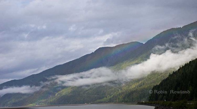
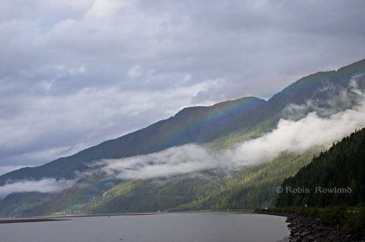
A rainbow hugs the mountains near the Telegraph Point rest area on the Skeena River between Terrace and Prince Rupert, Sept. 29, 2014. Traffic is seen on the narrow corridor between the mountains and the river (Robin Rowland/Northwest Coast Energy News)
Alternatives to Kitimat?
Now the new premier of Alberta, Jim Prentice, who should know better if he’s going to lead that province, is hinting that Kitimat isn’t the only possible solution for the Northern Gateway.
Without specifying Prince Rupert, according to Gary Mason reporting in The Globe and Mail, Prentice was speculating about an alternative to Kitimat.
Asked whether he believes the Gateway terminus should be relocated to Prince Rupert or another destination, Mr. Prentice said, “Everything I’ve heard from the Haisla who live there is they don’t agree with the terminal being in Kitimat.” Is it possible to get First Nations approval if there is no support at the planned terminus site? “It’s pretty tough,” the Premier said.
Prince Rupert has a thriving local fishing industry that employs hundreds of people and is critically important to the local First Nations. He is convinced the community would not be willing to put that at risk.
“Overwhelmingly people in my community are much more comfortable with liquefied natural gas, with wood pellets, with coal, than any oil product,” he said.
The Prince Rupert Port Authority also rejected the idea
A spokesman for the Prince Rupert Port Authority said Wednesday there is currently no room for Enbridge to build at the port even if it wanted to. “We are fully subscribed,” Michael Gurney said. There are two large vacant lots within the port authority’s jurisdiction, but both are locked by other energy companies, earmarked for LNG projects.
So not only is there no room on the road to Prince Rupert, there is no room in Prince Rupert.
Shovel-ready?
Let’s just consider for a moment that if Prince Rupert was the ideal location for the Northern Gateway terminal (which it is not), what would be needed to get the project going today.
The Northern Gateway Joint Review Panel would have be reconstituted or a new JRP created by the National Energy Board. That’s because the bitumen comes from Bruderheim, Alberta, crossing provincial boundaries and thus it’s in federal jurisdiction.
Even under the fast track rules imposed on the NEB by Stephen Harper’s Conservative government, new environmental and social impact studies would be required, starting from scratch. So add another five years of paperwork before a single shovel goes into the ground.
The pipeline would have to cross the traditional territory of First Nations that, so far, have not been part of the negotiations, mostly the Tsimshian First Nation as well as the Nisga’a First Nation which has a treaty establishing local rule over their territory.
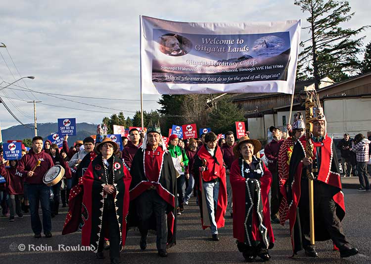
Traditional leaders of the Gitga’at First Nation lead a protest march through the streets of Prince Rupert, February 4, 2012. (Robin Rowland/Northwest Coast Energy News)
In February 2012, the largest anti-Enbridge demonstration outside of the Lower Mainland took place in Prince Rupert, with the elders of the Tsimshian First Nation welcoming the elders and members of the Gitga’at First Nation, at Hartley Bay, which had organized the protest.
When I say there isn’t room for a pipeline along the Skeena, it also means that there isn’t any room for the pipeline corridor right-of-way. Enbridge, in its submissions to the Joint Review Panel, said it requires a 25 metre wide right of way for the pipeline corridor. (For the record that’s just over 82 feet).
Along that highway, as you will see, there’s barely enough room for the CN mainline and Highway 16 (also known as the Yellowhead Highway) and on a lot of places both the highway and the railway roadbed are built on fill along the side of a cliff.
Albertans’ desperate desire to see the Northern Gateway go to anywhere to what they call “tide water” keeps coming up like the proverbial bad penny. The latest came when Jim Prentice speculated about a new route for the Northern Gateway.
I knew I had an appointment coming up in Prince Rupert on Monday, September 29. So I decided that only way to prove to people sitting in Calgary, Edmonton and Fort McMurray playing with Google Maps that the pipeline to Prince Rupert was a really dumb idea was to shoot photographs to show just why the Northern Gateway will never go to Prince Rupert—at least along the Skeena.
As you drive out of Terrace, you pass two large swing gates (also called by some “Checkpoint Charlie” gates after the Cold War era crossing in Berlin.) At the first rest stop west of Terrace, there are another set of gates at the Exstew. There’s a third set of gates just outside Prince Rupert.
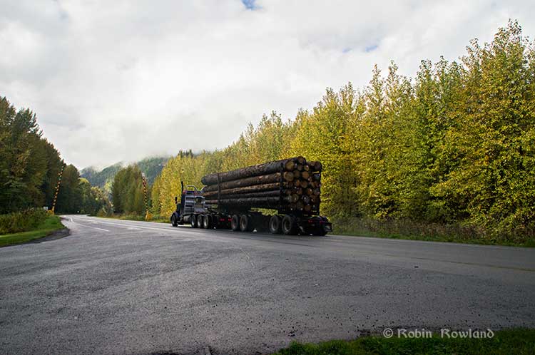
A logging truck passes the avalanche gates at Exstew on Highway 16, Sept. 29, 2014. (Robin Rowland)
The swing gates are avalanche gates and, in the winter, Highway 16 can be shut down if an avalanche closes the highway or the danger from avalanche is too great to allow motorists to proceed. When you drive the highway from Terrace to Prince Rupert in the winter (the signs were covered up when I drove Monday) you are warned “Avalanche danger Next 13 kilometres. No stopping.”
The Exstew avalanche gates, (Robin Rowland/Northwest Coast Energy News)
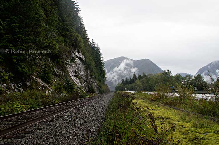
The drive along the Skeena from just west of Exchamsiks River Provincial Park all the way to Tyee where the highway turns inland to reach northwest to Prince Rupert on Kaien Island is one of the most spectacular drives on this planet. The highway snakes along a narrow strip of land with steep mountain cliffs on one side and the vast river on the other.
The problem is that apart from locals and tourists, none of the “experts” whether journalist, think tanker, bureaucrat or politician have, apparently ever driven from Prince Rupert to Terrace.
When both Opposition Leader Tom Mulcair and Liberal Leader Justin Trudeau were in the northwest earlier this summer to “engage” with the local people, apart from short boat trips down Douglas Channel, they flew everywhere. Scheduling you know. Stephen Harper has never visited northwest BC and probably never intends to. His cabinet members fly in for photo ops and then are on the next plane out of town.
Of all the visiting journalists who have come to the northwest only a couple have bothered to drive around the region. Most fly-in fly-out. These days, most often budget-strapped reporters never leave their offices, interviewing the same usual suspects by phone on every story.
On Monday, I took most of the photographs on my way back from Prince Rupert to Terrace after my appointment, so the sequence is from west to east. There are also very few places along the river where you can safely stop. There are concrete barricades on both sides of the highway to prevent vehicles either going into the river or onto the narrow CN right-of-way.
There are, however, two rest stops and a number of small turnoffs on the highway, the turnoffs mainly intended for use by BC Highways, but which are also used by tourists, fishers and photographers.
The first image was taken at one of those highway turnoffs just east of Aberdeen Creek. This is what the highway and rail corridor are like all along the Skeena, the highway, bounded by concrete barricades, the CN rail line and then the towering mountains. Note where the telegraph and telephone lines are—further up the cliffside.
A closer view of the highway and rail corridor just east of Aberdeen Creek.
Here is the view of the Skeena River from the Aberdeen Creek turnoff. You can see to the east, a mountain and the narrow strip of fill land that supports the highway and the rail line.
You see the broad width of the mighty Skeena, the Misty River, as it is called by the Tsimshian First Nation and by everyone else who lives in the northwest and on the right side of the image, the highway and rail corridor built on fill.
Any room for a pipeline?
There’s another turnoff on the other side of the headland east of Aberdeen Creek, looking back the way we came.
The final small turnoff is just by the Kylex River. Again you can see how narrow the highway and rail corridor are.
A few kilometres further along—as I said the highway snakes and curves its way along the riverbank– you come to the Basalt Creek rest area. So this telephoto image shows a logging truck heading west, taken from Basalt Creek, looking back at the highway.
Again you can see both the highway and CN line are built on fill. Is there any room for a pipeline?
Any room for a 25 metre pipeline right-of-way?
Between Basalt Creek and Telegraph Point, a few kilometres to the east, again the highway and rail line hug the narrow strip between the river and mountains.
This shot, taken from Telegraph Point, in October 2013, shows a CN intermodal container train heading to Prince Rupert. The container trains and the coal trains usually have between 150 and 180 cars. If a winter avalanche took out a train, there would be environmental damage, but that damage would be insignificant from coal or containers compared to a train of railbit tankers carrying diluted bitumen.
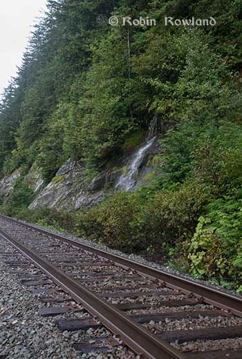
At Telegraph Point, the second of the three rest stops between Prince Rupert and Terrace, again there is just a narrow strip between the mountain, the highway and the river.
Across the highway from the rest stop, you can again see the narrow corridor, the first shot looking west the rail line close to the cliff face, the second, east, with the waterfall, which you don’t see during the rest of the year, fed by the fall monsoon.
Two shots from the same location, Telegraph Point, taken in March, 2013, of a CN locomotive hauling empty coal cars back to the fields around Tumbler Ridge. (No waterfall in March)
Alternative routes
Everyone has assumed that if Northern Gateway changed its route, the most likely choice given the configuration of the pipeline at the moment is to follow the Skeena.
There are alternatives. The Petronas LNG project and its partner TransCanada Pipelines have proposed a more northern cross-country route, which would go north from the Hazeltons, avoiding the Skeena
If Enbridge wanted to try a northern route, similar to the one TransCanada contemplates for Petronas, Northern Gateway would again run into trouble.
It would require reopening or creating a new Joint Review Panel, many more years of environmental and social impact studies of the route, even under Stephen Harper’s fast track system. The TransCanada/Petronas pipeline would also cross the traditional territory of the Gitxsan First Nation and if Enbridge tried that the company would have to deal with the fact that it signed a controversial agreement with Elmer Derrick that was immediately repudiated by most members of the Gitxsan First Nation and eventually dropped by Enbridge.
So why does this idea of a pipeline to Prince Rupert keep coming up?
In most cases, the idea of the pipeline to Prince Rupert is always proposed by Albertans, not from any credible source in British Columbia, or the suggestions come from desk bound analysts in Toronto and Ottawa both in think tanks and in the newsrooms of dying newspapers who have never seen the Skeena River apart from a tiny handful who have looked at Google Street View
(Yes you can Google Street View Highway 16 along the Skeena, I recommend it if you can’t do the drive)
Perhaps the worst example of this failure of both analysis and journalism came in the Edmonton Journal on July 7,2014, when it published a piece by Bob Russell, entitled Opinion: Make Prince Rupert the terminus, which went over the same old inaccurate arguments.
The overland route currently proposed by Enbridge is fraught with environmental issues because it goes over coastal mountains and streams before entering Kitimat’s port. This port will also be the base of perhaps as many as four liquefied natural gas terminals, which will result in the channel always busy with LNG ships outbound and returning from many Asian ports.
There are existing rights of way for the major highway, the Yellowhead, and CN Rail line from Edmonton to the Port of Prince Rupert, so this eliminates the issue of transgressing First Nations lands. The technical issues of narrow passages can be overcome with engineering. In fact, the pipeline can be buried in the roadway at some restricted locations if absolutely necessary, but two different engineers have assured me that for the most part, the right of way should be able to handle the pipeline. A vital factor, of course, is to reduce the impact by eliminating the need for two pipelines.
The clue is how the Edmonton Journal describes Russell;
Bob Russell has an extensive background in planning and was a member of the Edmonton Metro Regional Planning Commission. He has flown the Douglas Channel, visited Kitimat and toured the Port of Prince Rupert.
This is so typical of the Albertan attitude toward northwest British Columbia, people fly in for a couple of days, make a quick observation, and fly out again and present themselves as experts on the region. (Some “experts” on Kitimat, very active on Twitter have apparently never left Calgary).
It obvious that the “two engineers” who assured him “the right-of-way could handle of pipeline” have no idea what they’re talking about. As the photos show there is barely enough room for a highway and a rail line much less a 25 metre wide pipeline corridor.
If the pipeline was to be built as Russell proposed, the only highway between Prince Rupert and the rest of Canada would have to be closed for years, there are no detours. All so a pipeline can be buried under the asphalt not in solid ground, but in the fill on the side of a riverbank in an avalanche zone?
Of course, closing a highway up here won’t inconvenience anyone in Edmonton or Calgary, will it?
Would CN be happy with years of disruption of their lucrative traffic to Prince Rupert with grain and coal outbound to Asia and all those containers coming in to feed Chinese products to the North American market? (you can be sure Walmart wouldn’t be happy about that, not to mention prairie farmers including those from Alberta)
Russell’s statement
There are existing rights of way for the major highway, the Yellowhead, and CN Rail line from Edmonton to the Port of Prince Rupert, so this eliminates the issue of transgressing First Nations lands.
Is also inaccurate.
I was told by First Nations leaders during the Idle No More demonstrations in the winter of 2013, that, a century ago, when the Grand Trunk built the railway along the Skeena , they did just that, built it without consulting the First Nations along the route, sometime digging up native cemeteries and sacred spots.
While apparently CN has worked in recent years to improve relations with the First Nations along the rail line, according to those leaders some issues of right-of-way remain to be resolved.
If there were any plans to build a diluted bitumen pipeline along that route, that would likely mean another court battle adding to those already before the Federal Court, a court battle that would cost Enbridge, CN, the federal government, environmental NGOs and the First Nations more millions in lawyers’ fees.
It’s doubtful if in the long gone (and perhaps mythical) days of “get it right” journalism that the Russell opinion piece would have passed the scrutiny of an old fashioned copy editor and fact checker.
In 2012, the Edmonton Journal (in a story no longer available on their website) also cited former Alberta Premier Peter Lougheed and former Bank of Canada governor David Dodge, as also favouring Prince Rupert.
Dodge, who was in Edmonton Tuesday to deliver a speech on the global economic outlook at MacEwan University, said Enbridge’s proposed Northern Gateway pipeline to Kitimat looks like even more of a long shot.
“I think the project to Kitimat looks, objectively, more risky. So why hasn’t much greater effort gone into looking at Prince Rupert and taking (bitumen) out that way? My guess is, the easiest place to get B.C. to buy into the project would be to go to Rupert.”
Dodge’s views echo those of former Alberta Premier Peter Lougheed, who also favours looking at an alternate pipeline route to Prince Rupert, where ocean-going supertankers can navigate more easily.
Back in 2012, I finished my piece for the Huffington Post by saying:
So why do people insist, despite the evidence, that the Northern Gateway go to Prince Rupert? It’s no longer an pipeline; it’s emotion and ideology. Ideology in that opposition to the Northern Gateway is seen by conservatives as heretical opposition to free enterprise itself. Emotion among those who see promoting the oil patch as an issue of “Alberta pride” and even Canadian patriotism.
For the promoters of the pipeline to Prince Rupert, ignoring the science of geology and the study of geography across all of northwestern B.C. is no different than repeatedly knocking your head against the Paleozoic metamorphic greenstone of the mountain cliffs along the Skeena. It only gives you a headache.
Things haven’t gotten much better in the past two years. In fact they’re getting worse as opposition to pipelines mounts.
It seems that in 2014 the Alberta and the federal government policy in promoting pipelines Northern Gateway, KinderMorgan’s TransMountain, Keystone XL, Line 9 Reversal and Energy East (slick PR and smiling representatives at open houses, politicians at strictly controlled photo ops) is to ignore facts on the ground and to refuse to deal with the concerns of local people from coast to coast.
There could, perhaps, be a more inclusive and truly science-based pipeline planning process that could see pipelines go on optimum routes but that isn’t happening.
The policy for the oil patch and its politician supporters when it comes to pipelines is facts and geology don’t really matter. So they put on ruby slippers, knock their heels together three times and send pipelines down a yellow brick road to an Emerald City (while telling the locals to ignore the man behind the curtain)
The United States says acidification of the oceans means there is an already growing risk to the northwest coast fishery, including crab and salmon, according to studies released by the National Oceanic and Atmospheric Administration.
As more carbon dioxide is released into the atmosphere and absorbed by the oceans, the water is becoming more acidic and that affects many species, especially shellfish, dissolving the shells.
A NOAA study released today of environmental and economic risks to the Alaska fishery says:
Many of Alaska’s nutritionally and economically valuable marine fisheries are located in waters that are already experiencing ocean acidification, and will see more in the near future…. Communities in southeast and southwest Alaska face the highest risk from ocean acidification because they rely heavily on fisheries that are expected to be most affected by ocean acidification…
An earlier NOAA study, released in April, identified a long term threat to the salmon fishery as small ocean snails called pteropods which are a prime food source for pink salmon are already being affected by the acidification of the ocean.
This photograph from NOAA of a pteropod, important in the ocean diet of pink salmon, shows the first evidence of marine snails from the natural environment along the U.S. West Coast with signs that shells are dissolving. (NOAA)
NOAA says:
The term “ocean acidification” describes the process of ocean water becoming more acidic as a result of absorbing nearly a third of the carbon dioxide released into the atmosphere from human sources. This change in ocean chemistry is affecting marine life, particularly the ability of shellfish, corals and small creatures in the early stages of the food chain to build skeletons or shells.
Today’s NOAA study is the first published research by the Synthesis of Arctic Research (SOAR) program, which is supported by an US inter-agency agreement between NOAA’s Office of Oceanic and Atmospheric Research and the Bureau of Ocean Energy Management (BOEM) Alaska Region.
Des Nobles, President of Local #37 Fish [UFAWU-UNIFOR] told Northwest Coast Energy News that the fisheries union and other fisheries groups in Prince Rupert have asked both the Canadian federal and the BC provincial governments for action on ocean acidification. Nobles says so far those requests have been ignored,
Threat to crabs
The studies show that red king crab and tanner crab grow more slowly and don’t survive as well in more acidic waters. Alaska’s coastal waters are particularly vulnerable to ocean acidification because of cold water that can absorb more carbon dioxide and unique ocean circulation patterns which bring naturally acidic deep ocean waters to the surface.
“We went beyond the traditional approach of looking at dollars lost or species impacted; we know these fisheries are lifelines for native communities and what we’ve learned will help them adapt to a changing ocean environment,” said Jeremy Mathis, Ph.D., co-lead author of the study, an oceanographer at NOAA’s Pacific Marine Environmental Laboratory in Seattle, and the director of the University of Alaska Fairbanks School of Fisheries and Ocean Sciences Ocean Acidification Research Center.
As for Dungeness crab, Sarah Cooley, a co-author of the Alaska study, who was with the Woods Hole Oceanographic Institution at the time, told Northwest Coast Energy News, “The studies have not been done for Dungeness crab that have been done for king and tanner crab, that’s something we’re keenly aware of. There’s a big knowledge gap at this point.” She says NOAA may soon be looking at pilot study on Dungeness crab.
A healthy pteropod collected during the U.S. West Coast survey cruise. (NOAA)
Risk to Salmon, Mackerel and Herring
In a 2011-2013 survey, a NOAA-led research team found the first evidence: “that acidity of continental shelf waters off the West Coast is dissolving the shells of tiny free-swimming marine snails, called pteropods, which provide food for pink salmon, mackerel and herring.”
The survey estimated that the percentage of pteropods along the west coast with dissolving shells due to ocean acidification had “doubled in the near shore habitat since the pre-industrial era and is on track to triple by 2050 when coastal waters become 70 percent more corrosive than in the pre-industrial era due to human-caused ocean acidification.”
That study documented the movement of corrosive waters onto the continental shelf from April to September during the upwelling season, when winds bring water rich in carbon dioxide up from depths of about 120 to 180 metres to the surface and onto the continental shelf.
“We haven’t done the extensive amount of studies yet on the young salmon fry,” Cooley said. “I would love to see those studies done. I think there is a real need for that information. Salmon are just so so important for the entire Pacific Northwest and up to Alaska.”
In Prince Rupert, Barb Faggetter, an independent oceanographer whose company Ocean Ecology has consulted for the fisherman’s union and NGOs, who was not part of the study, spoke generally about the threat of acidification to the region.
She is currently studying the impact of the proposed Liquified Natural Gas terminals that could be built at Prince Rupert near the Skeena River estuary. Faggetter said that acidification could affect the species eaten by juvenile salmon. “As young juveniles they eat a lot of zooplankton including crustaceans and shell fish larvae.”
She added, “Any of the shell fish in the fishery, including probably things like sea urchins are all organisms that are susceptible to ocean acidification because of the loss of their capacity to actually incorporate calcium carbonate into their shells.”
Faggetter said her studies have concentrated on potential habitat loss near Prince Rupert as a result of dredging and other activities for liquified natural gas development, She adds that ocean acidification “has been a consideration that climate change will further worsen any potential damage that we’re currently looking at.”
Her studies of the Skeena estuary are concentrating on “rating” areas based on the food supply available to juvenile salmon, as well as predation and what habitat is available and the quality of that habitat to identify areas that “are most important for the juvenile salmon coming out of the Skeena River estuary and which are less important.”
She said that climate change and ocean acidification could impact the Skeena estuary and “probably reduce some of the environments that are currently good because they have a good food supply. If ocean acidification reduces that food supply that will no longer be good habitat for them” [juvenile salmon].
Bongo nets are deployed up to 200 meters deep to catch marine snails (pteropods), which are indicators of the progress of ocean acidification. The pteropod samples were collected during the U.S. West Coast survey cruises in 2011 and 2013. Unlike the US, Canada’s DFO is using models to track what’s happening to pteropods. (NOAA)
The August 2011 NOAA survey of the pteropods was done at sea using “bongo nets” to retrieve the small snails at depths up to 200 metres. The research drew upon a West Coast survey by the NOAA Ocean Acidification Program in that was conducted on board the R/V Wecoma, owned by the National Science Foundation and operated by Oregon State University.
Nina Bednarsek, Ph.D., of NOAA’s Pacific Marine Environmental Laboratory in Seattle, the lead author of the April pteropod paper said, “Our findings are the first evidence that a large fraction of the West Coast pteropod population is being affected by ocean acidification.
“Dissolving coastal pteropod shells point to the need to study how acidification may be affecting the larger marine ecosystem. These near shore waters provide essential habitat to a great diversity of marine species, including many economically important fish that support coastal economies and provide us with food.”
Ecology and economy
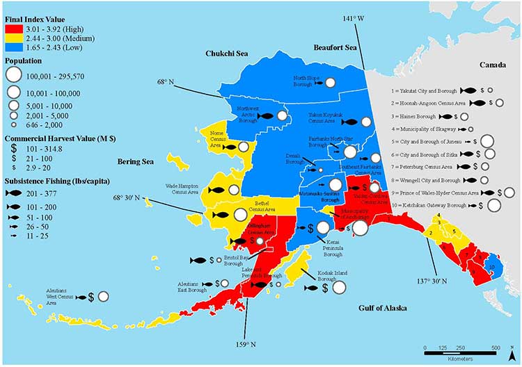
Today’s study on the effects of acidification on the Alaska fishery study examined the potential effects on a state where the fishing industry supports over 100,000 jobs and generates more than $5 billion in annual revenue. Fishery-related tourism also brings in $300 million annually to the state.
A map of Alaska shows the economic and ecological risks to parts of the state from ocean acidification. (NOAA)
The study also shows that approximately 120,000 people or roughly 17 percent of Alaskans rely on subsistence fisheries for most, if not all of their dietary protein. The Alaska subsistence fishery is open to all residents of the state who need it, although a majority of those who participate in the subsistence fishery are Alaska’s First Nations. In that way it is somewhat parallel to Canada’s Food, Ceremonial and Social program for First Nations.
“Ocean acidification is not just an ecological problem—it’s an economic problem,” said Steve Colt, Ph.D., co-author of the study and an economist at the University of Alaska Anchorage. “The people of coastal Alaska, who have always looked to the sea for sustenance and prosperity, will be most affected. But all Alaskans need to understand how and where ocean acidification threatens our marine resources so that we can work together to address the challenges and maintain healthy and productive coastal communities.”
The Alaska study recommends that residents and stakeholders in vulnerable regions prepare for environmental challenge and develop response strategies that incorporate community values and needs.
“This research allows planners to think creatively about ways to help coastal communities withstand environmental change,” said Cooley, who is now science outreach manager at Ocean Conservancy, in Washington, D.C. “Adaptations can be tailored to address specific social and environmental weak points that exist in a community.
“This is really the first time that we’ve been able to go under the hood and really look at the factors that make a particular community in a borough or census are less or more vulnerable from changing conditions resulting from acidification. It gives us a lot of power so that we don’t just look at environmental issues but also look at the social story behind that risk.”
As for the southern part of the Alaska panhandle nearest British Columbia, Cooley said, “What we found is that there is a high relative risk compared to some of the other areas of Alaska and that is because the communities there undertake a lot of subsistence fishing, There tend not be a whole lot of commercial harvests in the fisheries there but they are very very important from a subsistence stand point… And they’re tied to species that we expect to be on the front line of acidification, many of the clam species that are harvested in that area and some of the crab species.”
Long term effects
Libby Jewett, Director of the NOAA Ocean Acidification Program and author of the pteropod study said, “Acidification of our oceans may impact marine ecosystems in a way that threatens the sustainability of the marine resources we depend on.
“Research on the progression and impacts of ocean acidification is vital to understanding the consequences of our burning of fossil fuels.”
“Acidification is happening now,” Cooley said. “We have not yet observed major declines in Alaskan harvested species. In Washington and Oregon they have seen widespread oyster mortality from acidification.
“We don’t have the documentation for what’s happening in Alaska right now but there are a lot of studies staring up right now that will just keep an eye out for that sort of thing, Acidification is going to be continuing progressively over the next decades into the future indefinitely until we really curb carbon dioxide emissions. There’s enough momentum in the system that is going to keep acidification advancing for quite some time.
“What we need to be doing as we cut the carbon dioxide, we need to find ways to strength communities that depend on resources and this study allows us to think differently about that and too really look at how we can strengthen those communities.
Faggetter said. “It’s one more blow to an already complex situation here, My study has been working particularly on eel grass on Flora Bank (pdf) which is a very critical habitat, which is going to be impacted by these potential industrial developments and that impact will affect our juvenile salmon and our salmon fishery very dramatically, that could be further worsened by ocean acidification.”
She said that acidification could also be a long term threat to plans in Prince Rupert to establish a geoduck fishery (pronounced gooey-duck).
The popular large 15 to 20 centimetre clam is harvested in Washington State and southern BC, but so far hasn’t been subject to commercial fishing in the north.
NOAA said today’s study shows that by examining all the factors that contribute to risk, more opportunities can be found to prevent harm to human communities at a local level. Decision-makers can address socioeconomic factors that lower the ability of people and communities to adapt to environmental change, such as low incomes, poor nutrition, lack of educational attainment and lack of diverse employment opportunities.
NOAA’s Ocean Acidification Program and the state of Alaska are also developing tools to help industry adapt to increasing acidity.
The new NOAA study is the first published research by the Synthesis of Arctic Research (SOAR) program. which is supported by an inter-agency agreement between NOAA’s Office of Oceanic and Atmospheric Research and the Bureau of Ocean Energy Management (BOEM) Alaska Region.
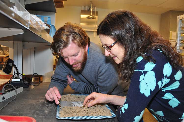
Iain McKechnie and Dana Lepofsky examine ancient herring fish bones that tell the story about how gigantic herring fisheries were for thousands of years in the Pacific Northwest. (SFU)
The herring, now dwindling on on the Pacific Coast, was once “superabundant” from Washington State through British Columbia to Alaska and that is a warning for the future, a new study says.
A team of scientists lead by Simon Fraser University argue that the archaeological record on the Pacific Coast offers a “deep time perspective” going back ten thousand years that can be a guide for future management of the herring and other fish species.
An archaeological study looked at 171 First Nations’ sites from Washington to Alaska and recovered and analyzed 435,777 fish bones from various species.
Herring bones were the most abundant and dating shows that herring abundance can be traced from about 10,700 years ago to about the mid-nineteenth century with the arrival of Europeans and the adoption of industrial harvesting methods by both settlers and some First Nations.
That means herring were perhaps the greatest food source for First Nations for ten thousand years surpassing the “iconic salmon.” Herring bones were the most frequent at 56 per cent of the sites surveyed and made up for 49 per cent of the bones at sites overall.
The study is one of many initiatives of the SFU-based Herring School, a group of researchers that investigates the cultural and ecological importance of herring.
“By compiling the largest data set of archaeological fish bones in the Pacific Northwest Coast, we demonstrate the value of using such data to establish an ecological baseline for modern fisheries,” says Iain McKechnie. The SFU archaeology postdoctoral fellow is the study’s lead author and a recent University of British Columbia graduate.
Co-author and SFU archaeology professor Dana Lepofsky states: “Our archaeological findings fit well with what First Nations have been telling us. Herring have always played a central role in the social and economic lives of coastal communities. Archaeology, combined with oral traditions, is a powerful tool for understanding coastal ecology prior to industrial development.”
The researchers drew from their ancient data-catch concrete evidence that long-ago herring populations were consistently abundant and widespread for thousands of years. This contrasts dramatically with today’s dwindling and erratic herring numbers.
“This kind of ecological baseline extends into the past well beyond the era of industrial fisheries. It is critical for understanding the ecological and cultural basis of coastal fisheries and designing sustainable management systems today,” says Ken Lertzman, another SFU co-author. The SFU School of Resource and Environmental Management professor directs the Hakai Network for Coastal People, Ecosystems and Management.
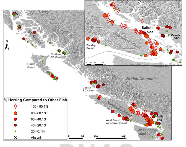
Map of First Nations’ archaeological sites with high numbers of fish bones. Herring is abundant in sites throughout the Strait of Georgia. In 71% of sites, herring makes up at least 20 per cent of the bones found at the site. (SFU/PNAS)
Heiltsuk tradition
The paper says that the abundance of herring is additionally mirrored in First Nations’ place
names and origin narratives. They give the example of the 2,400-y-old site at Nulu where herring
made up about 85 per cent of the fish found in local middens. In Heiltsuk oral tradition, it is Nulu where Raven first found herring. Another site, 25 kilometres away at the Koeye River, has only has about 10 per cent herring remains and is not associated with herring in Heiltsuk tradition.
(In an e-mail to Northwest Coast Energy News, McKechnie said “there is a paucity of archaeological data from Kitimat and Douglas Channel. There is considerable data from around Prince Rupert, the Dundas Islands and on the central coast Namu/Bella Bella/ Rivers Inlet area and in southern Haida Gwaii.”)
The study says that the archaeological record indicates that places with abundant herring were consistently harvested over time, and suggests that the areas where herring massed or spawned were more extensive and less variable in the past than today. It says that even if there were natural variations in the herring population, the First Nations harvest did not affect the species overall.
It notes:
Many coastal groups maintained family-owned locations for harvesting herring and herring roe from anchored kelp fronds, eel grass, or boughs of hemlock or cedar trees. Herring was harvested at other times of the year than the spawning period when massing in local waters but most ethnohistorical observations identify late winter and springtime spawning as a key period of harvest for both roe and fish.
The herring and herring roe were either consumed or traded among the First Nations.
Sustainable harvests encouraged by building kelp gardens,wherein some roe covered fronds were not collected, by minimizing noise and movement during spawning events, and by elaborate systems of kin-based rights and responsibilities that regulated herring use and distribution.
Industrial harvesting
Industrial harvesting and widespread consumption changed all that. Large numbers of herring were harvested to for rendering to oil or meal. By 1910, the problem was already becoming clear. In that year British Columbia prohibited the reduction of herring for oil and fertilizer. There were reports at that time that larger bays on the Lower Mainland were “being gradually deserted by the larger schools where they were formerly easily obtained.”
But harvesting continued, in 1927 the fishery on eastern Vancouver Island, Columbia, processed
31,103 tons of herring. The SFU study notes that that is roughly twice the harvest rate for 2012 and would also be about 38 per cent of the current herring biomass in the Strait of Georgia.
In Alaska, reduction of herring began in 1882 and reached a peak of 75,000 tons in 1929.
As the coastal populations dwindled, as with other fisheries, the emphasis moved to deeper water. By the 1960s, the herring populations of British Columbia and Washington had collapsed. Canada banned herring reduction entirely in 1968, Washington followed in the early 1980s.
In the 1970s, the herring population off Japan collapsed, which opened up the demand for North American roe, which targeted female herring as they were ready to spawn. That further reduced the herring population so that the roe fishery is now limited to just a few areas including parts of the Salish Sea and off Sitka and Togiak, Alaska.
The First Nations food, social and ceremonial herring fishery continues.
Government fishery managers, scientists, and local and indigenous peoples lack consensus on the cumulative consequences of ongoing commercial fisheries on herring populations. Many First Nations, Native Americans, Alaska Natives, and other local fishers, based on personal observations and traditional knowledge, hypothesize that local herring stocks, on which they consistently relied for generations, have been dramatically reduced and made more difficult to access following 20th century industrial fishing
Deep time perspective
The SFU study says that some fisheries managers are suggesting that the herring population has just shifted to other locations and other causes may be climate change and the redounding of predator populations.
But the study concludes, that:
Our data support the idea that if past populations of Pacific herring exhibited substantial variability, then this variability was expressed around a high enough mean abundance such that there was adequate herring available for indigenous fishers to sustain their harvests but avoid the extirpation of local populations.
These records thus demonstrate a fishery that was sustainable at local and regional scales over millennia, and a resilient relationship between harvesters, herring, and environmental change that has been absent in the modern era.
Archaeological data have the potential to provide a deep time perspective on the interaction between humans and the resources on which they depend.
Furthermore, the data can contribute significantly toward developing temporally meaningful ecological baselines that avoid the biases of shorter-term records.
Other universities participating in the study were the University of British Columbia, University of Oregon, Portland State University, Lakehead University, University of Toronto, Rutgers University and the University of Alberta.
Councillor Phil Germuth listens as District of Kitimat Council debates his motion that would have required Enbridge to enhance monitoring of leaks on the pipeline in the Kitimat watershed. (Robin Rowland/Northwest Coast Energy News)
District of Kitimat Council voted Monday night to hold a plebiscite on whether or not the community supports the controversial Enbridge Northern Gateway project.
District council and staff will decide the actual question for voters and the date for the plebiscite in the coming couple of weeks.
A staff report described a plebiscite as “a non-binding form of referendum,” as defined by the BC Local Government Act.
The council decision comes after the Northern Gateway Joint Review Panel released its decision on December 16, that approved the pipeline and tanker project along with 209 conditions.
After the release of the Joint Review decision, the District of Kitimat issued a news release saying, “Kitimat Council has taken a neutral stance with respect to Northern Gateway. Council will take the necessary time to review the report in order to understand the content and reasons for the decision.”
On January 16, 2012 the council adopted a resolution “that after the completion of the JRP process, the District of Kitimat survey the residents of Kitimat regarding their opinion on the Enbridge Northern Gateway project.” After the JRP decision, the District reaffrimed that it would “undertake a survey of Kitimat residents to determine their opinions of the project now that the JRP has concluded its process.”
District staff had recommended hiring an independent polling firm to conduct the survey, pointing to a pollster’s ability to craft the appropriate questions and provide quick results.
Council quickly shot down the idea. A motion by Councillor Mario Feldhoff to use a polling firm did not get a seconder.
Councillor Rob Goffinet, who made the motion for the plebiscite, noted that even as a politician he doesn’t answer phone calls from unknown numbers. He said, “People do not want a pollster to phone them and do a check list how do you feel on a project. How can we be assured if someone in or out of their home will answer a call from a pollster? I would give total responsibility to every adult citizen of Kitimat who has a point of view to express it in a yes or no ballot.”
Councillor Phil Germuth added, “Those are the same companies that went out prior to the last provincial election and said one party was going to wipe it out and we know what happened there.” Germuth was referring to BC Premier Christy Clark’s come from behind majority victory which was not predicted in the polls.
Germuth told the meeting he believed an unbiased question could be posed in the form of a referendum on the Northern Gateway project. “I have full confidence in our staff that they will be able, along with some assistance from council, to develop questions that are not going to appear biased. It should be very simple, yes means yes, no means no.”
Councillor Mario Feldhoff, who earlier in the evening had, for the first time, declared that he is in favour of the Northern Gateway project, told council that he preferred using a polling firm because it could come back with a “statistically significant” result.
Council voted six to one in favour of the plebiscite. The lone dissenter was Councillor Edwin Empinado who told his colleagues that a mail-in ballot, another of the options presented by staff, would be more inclusive. Empinado said he was concerned that a plebiscite would mean a low voter turnout.
Warren Waycheshen, the district’s deputy chief administrative officer, told council that the plebiscite would have to be held under the provisions of BC’s Local Government Act which covers elections and referenda, but with the plebiscite the council would have more flexibility in deciding how the vote would take place. The act would still cover such things as who was eligible to vote and the use of campaign signs.
Councillor Mario Feldhoff reads a statement at council, supporting the findings of the Joint Review panel on the Northern Gateway project. (Robin Rowland/Northwest Coast Energy News)
The neutrality that council had maintained for at least the previous three years began to break down during Monday’s meeting meeting when Germuth proposed a motion that would have required Enbridge to install within Kitimat’s jurisdiction a detection system capable of locating small volumes of leakage from the pipeline, a measure that is likely beyond the recommendations of the JRP decision.
It was then that Feldhoff became the first Kitimat councillor to actually declare for or against the Northern Gateway, telling council, saying he agreed with the JRP, “The overall risk was manageable and the project was in Canada’s interest. On the whole I am in favour of the conditions and recommendations of the JRP… Not only am I a District of Kitimat Councillor, I am a Canadian. To my mind, opposition to the JRP Northern Gateway report at this stage is yet another case of NIMBY-ism, not in my backyard.”
In the end, at Feldhoff’s urging, the council modified the original motion, so that it called on the District to meet with Enbridge to discuss an enhanced pipeline leak detection system where a leak could “impact the Kitimat watershed.”
It’s not clear what Council will do with the result of the plebiscite, since it is “non-binding.”
In the past two years, Terrace, Prince Rupert and Smithers councils, together with Kitimat Stikine Regional District and the Skeena Queen Charlotte Regional District, all voted to oppose Northern Gateway. Those were all council votes, taken without surveying local opinion.
Most of the decisions are in the hands of the federal government which has 180 days from the release of the JRP report to approve the project.
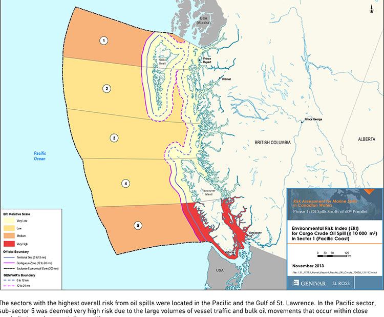
Transport Canada tanker report map shows current risk for spills in BC (Transport Canada)
Cover of Genivar tanker report (Transport Canada)
The possible effects of a bitumen spill on Pacific waters were not considered in the oil response preparedness report released last week by the Harper government, the background data study reveals.
The consulting firm that did the study for Transport Canada, Genivar Inc, had no reliable data on the effect of a bitumen tanker disaster—because, so far, there has been no major ocean disaster involving diluted bitumen.
Instead, Genivar, based its findings on potential hazards and response on existing data on crude oil spills.
The Genivar study, however, does warn, that if the Enbridge Northern Gateway project does go ahead, the spill risk from diluted bitumen carrying tankers in Douglas Channel and along the north Pacific coast will jump from “low” or “medium” to “very high.” If the twinning of the Kinder Morgan pipeline goes ahead, then the risk in Vancouver also jumps to “very high.”
The question of how bitumen might behave in the cold and choppy waters of the North Pacific was hotly debated during the Northern Gateway Joint Review hearings earlier this year. Enbridge Northern Gateway based its position on laboratory studies, studies that were challenged by environmental and First Nations intervenors, pointing both to the unknowns of the ocean environment and the continuing problems Enbridge has in cleaning up the spill in the Kalamazoo River in Michigan.
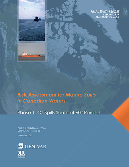
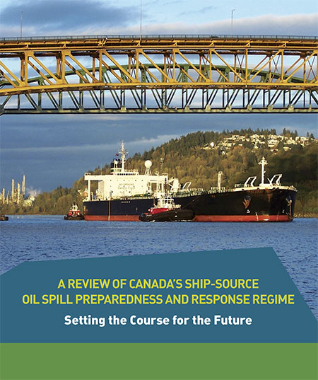
The Genivar report, Risk Assessment for Marine Spills in Canadian Waters Phase 1: Oil Spills South of 60th Parallel, was completed in November, then passed on to the “expert panel” that released their own report: A Review of Canada’s Ship-source Oil Spill Preparedness and Response Regime — Setting the Course for the Future. That second report was based not only on the data provided by Genivar but on the expertise of three panel members, their visits to some locations and input from government, industry, First Nations and municipalities.
The actual data report was not posted; it had to be requested through the Transport Canada website, which is how Northwest Coast Energy News obtained the background study.
The expert panel found “a very high risk” of oil spills in two areas of the Pacific Coast, in the north around the ports of Kitimat and Prince Rupert and in the heavy ocean traffic area of southern British Columbia, especially Port Metro Vancouver and into Washington State.
The expert panel made 45 recommendations that covered a wide range of issues including eliminating the present $161-million liability limit for each spill and replacing it with unlimited liability for polluters, annual spill training involving the Canadian Coast Guard, Environment Canada, provincial and local authorities and the private sector, increased and improved annual spill training exercises, basing risk assessment on local geography and conditions and faster emergency responses to spills.
The expert panel calls for greatly increased research on the ocean environment at a time that Harper government has been gutting environmental research across Canada, while spinning that its policies are “science based.”
The science and technology around both the movement of oil and spill response has advanced significantly over the past several decades. We feel that while some aspects of the Regime have kept pace with these developments, in some areas, Canada has fallen behind world-leading countries like Norway and France. This can be attributed to a general lack of investment in research and development as well as the lack of coordination between industry and government over research priorities.
The Government of Canada should work closely with industry to establish a national research and development program for oil spill preparedness and response. The program should be co-funded by industry and the Government, and the research priorities should be set through a collaborative process that involves academia, where possible. Like the Regime itself, we view this program as a partnership between industry and government.
We envision that this program would also seek to leverage the work being done internationally on oil spill preparedness and response. The program should seek to establish partnerships with other world-leading countries in order to stay current on international advances and new technologies.
The expert panel, however, does not say how the federal government is expected to pay for meeting BC Premier Christy Clark’s condition for a “world class” spill prevention and response system at a time that Finance Minister Jim Flaherty is determined to balance the budget and the Harper government is continuing to cut back government services.
Bitumen excluded
On bitumen, the Genivar data study says:
Modified bitumen products represent the majority of the “crude carried as cargo” in
Pacific sub-sector 5. They are not modelled as a separate category in this spill behaviour analysis but are represented as “persistent crude”.
Changes in spill behaviour depend to some extent on the environmental conditions at the time of the spill, as described in greater detail below. However, over the range of wind and sea conditions typically experienced in the Canadian marine environment, changes in oil properties are not overly sensitive to variations in climatic values, so a single set of wind and sea conditions will be used in the analysis.
The idea that “changes in oil properties” not being sensitive to variations in climate was also frequently challenged before the Joint Review Panel.
On the increase in traffic volume if the Northern Gateway project goes ahead, the Genivar report says.
Enbridge Inc. has proposed to construct a marine terminal at Kitimat, B.C. and a dual pipeline from the terminal to oil sands production in northern Alberta. The terminal would handle up to 193,000 barrels/day of imported diluents (i.e., low-gravity condensate) that would be piped to Alberta and used to dilute bitumen to enhance its flow properties. The diluted bitumen would then be piped to Kitimat at rates up to 525,000 barrels/day that would be shipped by tanker to export to markets in Asia and California.
At full capacity, the import of diluent and export of diluted bitumen would total up to 35 Mt/year. This amount is comparable to the currently-shipped volume in the Pacific sector related to volumes being exported from Vancouver and related to volumes being exported from the Alaskan to Washington State trade.
It goes on to say that the current tanker traffic on the north Pacific coast “has negligible risk in the near shore and intermediate zones, but significant potential spill frequency in the deep-sea zone related to the Alaskan trade.” Similarly, according to Genivar the environmental risk in the region “currently ranges from ‘medium’ to “very low” from near shore to deep-sea zones, respectively…. mainly driven by a combination of physical and biological features.”
The increase in traffic from Northern Gateway would likely increase the environmental risks. The the near shore risk from would jump from “very low” to “very high.” For the largest spill category, deep-sea risk would likely increase from “low” to “medium.”
No data on recreational or traditional First Nations fishery
To study the effect on an oil spill on the fishery, Genivar used data from the Department of Fisheries and Oceans as the provinces to gauge “the port value of commercial fishing and the value of the fish, shellfish and aquaculture” in each zone it studied and then compared it to the the national averages for commercial fishery. Those figures included any commercial fishery by First Nations.
But Genivar noted, there is no reliable data on either the recreational fishery or the First Nations traditional, food, social and ceremonial fishery, saying:
It is important to highlight that this indicator does not consider recreational or traditional fishing. The importance of this industry is notable and an oil spill could damage the recreational fishing stock as well. However, the absence of comparable data and the fact that this study is restricted to federal and international data, and some provincial data from Quebec and Ontario for commercial fisheries, limits the ability to include recreational fishing… Nevertheless, as an absolute index, it will provide an overall vulnerability in the event of an oil spill.
The ongoing impact of cutbacks at Fisheries and Oceans has had a continuing impact on the northwest, especially in the controversial halibut recreational fishery, where DFO has admitted that it is basically guessing the size of each year’s recreational halibut catch.
Tourism
Genivar also notes that lack of reliable data on the effect on a oil spill on tourism. The consultants go so far as to say one of the indicators they will use to measure the effect of any oil spill on tourism would come from “data extracted from the 2011 National Household Survey at the census division level and the accommodation and food services data will be used.”
The “National Household Survey” is also known as the long form census and it is the National Household Survey that the Harper government made voluntary rather mandatory, decreasing the reliability of the data. Global News recently analyzed those who had contributed to the survey and found that it poor people, the very rich and people in low population areas were least likely to fill out the voluntary census—which means the data for northwest BC is likely highly unreliable from the 2011 survey even though “The census divisions in coastal regions will be selected for each of the sub-sectors. This method will express the economic vulnerability of each sub-sector to a potential collapse in tourism following a spill.”
Despite the importance of cruise ship traffic on the west coast, Genivar notes, “In Canada, data for passenger vessels were unavailable.”
It also notes that “this study does not specifically take into account national parks and other landmarks, since their influence on tourism is indirectly included in the tourism employment
intensity index” so that Genivar could create what it calls the Human-Use Resource Index (HRI), even though that index appears to be based on incomplete data.
The list of participants in the oil spill preparedness and response study released last week by the federal government shows two glaring no shows, the District of Kitimat and Rio Tinto Alcan.
The Haisla Nation and the Gitga’at Nation did provide written submissions to the panel.
The expert panel was set up by the federal government to review “oil handling facilities and ship-source oil spill preparedness and response.” The expert panel was to review the “structure, functionality and the overall efficiency and effectiveness of the system, as well as analyzing the requirements for hazardous and noxious substances, including liquefied natural gas.”
The panel also invited any interested groups to submit documents or their own views to be taken into consideration.
Among the stakeholders interviewed by the panel were companies and organizations very familiar to Kitimat; Chevron and Shell, main partners in two of the LNG projects; Enbridge, which has proposed the Northern Gateway Pipeline and Kinder Morgan which has proposed expanding the dilbit pipeline on the Lower Mainland. Other stakeholders included Coastal First Nations, the Prince Rupert Port Authority, SMIT Marine and the Vancouver Port Authority.
As well as the Haisla and the Gitga’at, five west coast municipalities submitted their own reports to the tanker panel, both the city and districts of North Vancouver, the city of Richmond, the District of Ucluelet and the District of West Vancouver. San Juan County in Washington State also made a submission to the panel. So did the Prince Rupert and Vancouver Port authorities.
Chevron, Enbridge, Imperial Oil, Kinder Morgan, Pacific Northwest LNG, Seaspan Marine, and the Union of BC Municipalities, among others also submitted their views to the panel.
So why didn’t the District of Kitimat participate? When it came to the Enbridge Northern Gateway Joint Review, the mayor and council always maintained their neutrality motion meant that the District would not be an active participant. That was always a short sighted viewpoint. The District should have participated actively in the JRP in such a way as to protect the region’s interests where necessary while remaining neutral. If the District of Kitimat sat out the tanker panel because of the Northern Gateway neutrality policy, that was no excuse, because the expert panel’s mandate specifically included LNG.
Tanker traffic is a potential threat to the San Juan Islands (the Gulf Islands on the American side of the border). It is astounding that San Juan County would think that the Canadian tanker panel was important enough to make a submission and the District of Kitimat did not.
What about Rio Tinto Alcan? Kitimat has been a private port for 60 years, run first by Alcan and then by Rio Tinto Alcan. Why wasn’t RTA asked to participate as a stakeholder? Why didn’t RTA make a submission? Those who are pushing the Northern Gateway terminal always like to say that tankers have been calling at Kitimat for those 60 years. That is true. Of course, none of those tankers have been the Very Large Crude Carriers proposed by Northern Gateway. However, those 60 years means that RTA has the expertise on the Port of Kitimat and Douglas Channel. RTA probably has important data that could have helped both the expert panel and Genivar (which pointed out the paucity of data on small and medium sized tankers). In not participating in the tanker panel submissions and possibly not providing valuable data on Douglas Channel, RTA neglected its social responsibility both to the community of Kitimat and the rest of the province of British Columbia.
Aurora LNG, a partnership headed by Nexen, the Canadian branch of CNOOC, one of China’s largest energy companies, has applied to the National Energy Board for an export licence to ship 24 million tonnes of liquified natural gas over 25 years to Asian customers from Grassy Point near Prince Rupert.
Two Japanese companies, Inpex Corp and JGC are partners with CNNOC in the joint venture.
While the NEB is expected to grant the export licence with little difficulty, the company still has to go through environmental assessment and make a final investment decision.
So far none of the LNG projects in northwestern BC, including three in Kitimat where the NEB has already granted export licences, have been given that final go ahead from the boards of their parent companies. Tne NEB is also considering five other applications for LNG export licences.
At the time BC granted Nexen the potential tenure at Grassy Point, CEO Kevin Reinhart said: “Through project assessment and stakeholder consultation we are committed to examining the potential to build a best-in-class LNG facility – one that creates jobs, delivers lasting economic and social benefits and is developed with the environment top-of-mind.”
According to the BC government news release:
The agreement is for the northern part of Grassy Point, which covers 614.9 hectares of land, plus foreshore land equalling 158.7 hectares.
Aurora LNG will be examining the viability of constructing a liquefied natural gas (LNG) plant and export terminal at this location.
Under the agreement, Aurora LNG will pay $12 million to the Province upon signing the sole proponent agreement. Another $12 million will be paid by Aurora LNG on, or before, the first anniversary of the agreement, as long as the proponent wants the arrangement to continue.
The right to acquire the land for construction or long-term use remains a matter of future negotiations. If the land is acquired by Aurora LNG, the $24 million submitted to government will be subtracted from the final sale price.
Nexen’s plans include a natural gas liquefaction plant, LNG storage and a marine terminal to handle LNG tankers capable of carrying between 210,000 and 217,000 cubic metres of gas. The initial plans call for two trains with a possibility of two more if conditions in the always volatile LNG market warrant.
Nexen is in talks with a number of “major pipeline providers” and no pipeline route has been announced.
It is expected the first LNG shipment from Grassy Point would occur sometime between 2021 and 2023.
Media reports say that Japan Petroleum Exploration (Japex) has given final investment approval to build a liquified natural gas receiving terminal and storage facility at the Soma Port in Shinchi, Fukushima Prefecture to receive Canadian LNG, probably from Prince Rupert.
The company will also build a 40 kilometre connecting pipeline to move the natural gas to Japex’s main pipeline which will then connect with natural gas storage facilities in Natori in Miyagi Prefecture and another facility in Niigata Prefecture on the Sea of Japan.
The Soma port was severely damaged in the March, 2011, earthquake and tsunami.
“We want to help areas affected by the disaster to create employment and secure a stable supply of energy,” Shoichi Ishii, Japex senior managing director, was quoted by the Japanese newspaper Ashai Shimbum at a news conference on Nov. 27.
Japex owns 10 per cent of the planned Petronas LNG export terminal at Prince Rupert, which is expected to have an annual capacity of 12 million metric tons.
Japex plans to import 1.2 million tonnes of LNG made from Canadian shale gas a year starting in 2018. The construction of the new LNG terminal in Shinchi, is scheduled for completion in 2017 and will start in 2014, at a cost of $587 million US.
The reports say with LNG import facilities on both the east and west coasts, that means Japan is ensuring a stable supply of LNG. If an earthquake or tsunami hits one coast, the other would likely be spared.
Ashai Shimbum also reports that Japex is considering building at an LNG fired power plant near the planned import and storage facilities to sell power to the struggling and controversial Tokyo Electric Power Co, owner of the nuclear power plant in Fukushima Prefecture that was destroyed in the March, 2011, earthquake and tsunami.
The newspaper says that because Japex does not have experience operating a thermal plant, it intends to work with other companies to run the new powerhouse.