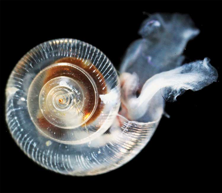
A new study concludes that British Columbia’s southern resident Orca pod is led by “post reproductively aged” females who help it survive during lean years.
According to the study, the older females serve as key leaders, directing younger members of the pod, and especially their own sons, to the best spots for landing tasty meals of salmon, helping their kin to survive. This leadership role takes on special significance in difficult years when salmon are harder to come by.
The researchers say the discovery offers the first evidence that a benefit of prolonged life after reproduction is that post-reproductive individuals act as repositories of ecological knowledge.
There are only three species on Earth where females go through menopause, human beings, killer whales and pilot whales.
Older females lead Orca pods in hard times. (Current Biology)
“Menopause is one of nature’s great mysteries,” says Lauren Brent of the University of Exeter in the United Kingdom. “Our study is the first to demonstrate that the value gained from the wisdom of elders may be one reason female killer whales continue to live long after they have stopped reproducing.”
The scientists say in their paper this also provides insights into why human women continue to live long after they can no longer have children.
Leadership by these females is especially prominent in difficult years when salmon abundance is low.
Female killer whales typically become mothers between the ages of 12 and 40, but they can live for more than 90 years. By comparison, male Orcas rarely make it past 50.
Resident pods feed mostly on Chinook salmon. Chinook make up than 90 per cent of their diet during the summer. The abundance of salmon fluctuates due to fishing by humans and weather changes such as El Nino and climate change. The study says that individual killer whales with information on where and when to find salmon provide other group members with considerable benefits.
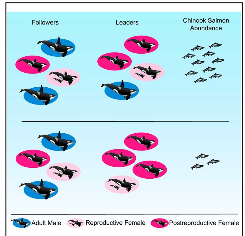
To find out who were the leaders of the Southern Resident pod, the team analyzed 751 hours of video footage taken over 35 years of as many as 102 Southern resident killer whales in the coastal waters of British Columbia and Washington engaged in directional travel , collected during nine summer salmon migrations. The scientists also used multigenerational demographic records have been recorded for the Southern resident killer whales since 1976, allowing them to know the family relationships of the Orcas.
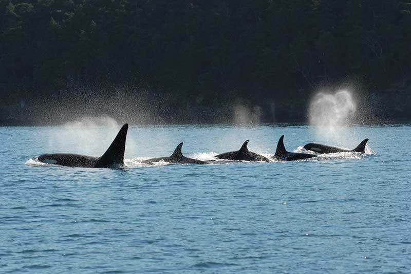
A killer whale pod swims in tight configuration. (David Ellifrit, Center for Whale Research)
The study found that in any given year, adult females were more likely to lead the pod’s group movement compared to adult males They concluded that Orca matriarchs over the age of 35 years “the mean age at last reproduction for Southern resident females that lived past the age of peak adult female mortality” were more likely to lead the pod “compared to reproductively aged females.”
The scientists then compared fisheries data on Chinook salmon abundance to whale behavior. It showed that “post-reproductively aged females were more likely to lead group movement in years when salmon abundance was low.”
The scientists concluded that shows that prolonged life after the reproductive years allows the “individuals act as repositories of ecological knowledge.”
In the case of Orcas, the post menopausal matriarchs “lead group movement in and around salmon foraging grounds, and this is exaggerated when salmon are in low supply and the selective pressure to locate food is at its highest.”
The researchers also found that females are more likely to lead their sons compared to their daughters.
Daniel Franks of the University of York explained: “Killer whale mothers direct more help toward sons than daughters because sons offer greater potential benefits for her to pass on her genes. Sons have higher reproductive potential and they mate outside the group, thus their offspring are born into another group and do not compete for resources within the mother’s matriline. Consistent with this, we find that males follow their mothers more closely than daughters.”
So how does the study of Orca elders apply to human beings?
“In humans, it has been suggested that menopause is simply an artefact of modern medicine and improved living conditions,” said Darren Croft of the University of Exeter. “However, mounting evidence suggests that menopause in humans is adaptive. In hunter-gatherers, one way that menopausal women help their relatives, and thus increase the transmission of their own genes, is by sharing food. Menopausal women may have also shared another key commodity – information.”
Recent studies show that living beyond the age of 60 is much more comon in hunter-gatherer cultures than previsouly believed.
So the study concludes that in humans:
In hunter-gatherers, one way that menopausal women help their relatives, and thus improve their own inclusive fitness, is by sharing food.
Menopausal women may also share another key commodity—information. Humans were preliterate for almost the entirety of our evolutionary history and information was necessarily stored in individuals. The oldest and most experienced individuals were those most likely to know where and when to find food, particularly during dangerous and infrequent conditions such as drought.
As for Orcas:
Wild resident killer whales do not have the benefits of medical care, but, similar to humans, females can live for more than 40 years after they have ceased reproducing. An individual resident killer whale’s ability to find salmon is crucial to their fitness; in years with low salmon abundance, resident killer whales are more likely to die and less likely to reproduce.
Our finding that postreproductively aged female killer whales are especially likely to lead group movement in years with low salmon abundance suggests that the ecological knowledge of elders helps explain why females of this species live long after they have stopped reproducing. Postreproductive female killer whales may provide other knowledge to their relatives. For example, postreproductive members of this socially complex species may have greater social knowledge that could help kin navigate social interactions.
In some other species, like African elephants, survival is enhanced in the presence of older female relatives, who are more capable of assessing social and predatory threats.
So the study asks “why is menopause restricted to some toothed whales and humans?”
The scientists believe that for evolution, menopause will only evolve when the benefits for the species outweigh the costs of terminating reproduction.
In humans, resident killer whales, and short-finned pilot whales, when a female usually stays in the immediate location of her family, that means that the benefits she can gain through helping her relatives, increases with age.
Among Southern resident Orcas, neither sex leaves the family pod and “females are born into groups with their mothers and older siblings.”
As the female resident Orca ages, her older relatives who die are replaced by “her own nondispersing sons and daughters.” In ancestral humans, resident killer whales and short-finned pilot whales, the benefits of the elders helping therefore increase with age, which is thought to predispose these three species to menopause
The study notes that Orcas have a number of different “ecotypes” or cultures “which differ in their prey specialization, morphology, and behavior, and which in some cases represent genetically distinct populations.” That means “that not all ecotypes are characterized by the same social structure as resident killer whales” where females leave their birth pod. The say more study is needed to find out if menopause occurs in those Orca pods and what the role of older females is in those pods. The study also did not look at the northern residents who frequently visit Douglas Channel.
Climate change, which will raise ocean temperatures and more carbon dioxide in the atmosphere which will increase the acidification of the oceans will have the greatest affect on the intertidal zones—and a key indicator species, crabs and similar creatures.
A study by San Fransisco State University published today in the Journal of Experimental Biology used the small (usually 15 millimetre) porcelain crab to simulate the conditions that will come to the intertidal zone and affect other species including the larger dungeness crab. ( According to Wikipedia, porcelain crabs are an example of carcinisation, whereby a non-crab-like animal,in this case a relative of a squat lobster evolves into an animal that resembles a true crab.)
A porcelain crab (Nick Hobgood via Wikipedia)
Studies have shown that as climate changes, coastal ecosystems will be see “have increased extremes of low tide-associated thermal stress and ocean acidification-associated low pH.”
The study by co-author Jonathan Stillman and his colleagues, is the first to explore intertidal zone organisms’ response to combined variation in temperature and pH, which is expected to intensify in the future due to climate change and ocean acidification.
The current and previous studies have shown that during low tide, air temperatures in the intertidal zone can fluctuate dramatically as much as 20 degrees celcius over short periods of time up to six hours. Temperatures can reach extremes when low tides coincide with hot days. Marine intertidal organisms tolerate these natural temperature fluctuations, yet it is known that they are limited in their scope to tolerate future warming.
In the simulation porcelain crabs were placed in a specially built aquarium designed to simulate the natural environment, including tidal changes. At low tide, with the crabs exposed to the air, the researchers varied the temperature to mirror day-to-day changes the crabs currently experience — such as cooler air on a cloudy day and warmer air on a sunny day — as well as conditions expected in the future. At high tide, with the crabs submerged, they adjusted pH levels in the same fashion.
As the temperature rose and pH levels dropped — conditions expected in the future due to climate change — the crabs’ ability to withstand heat increased. But at the same time, researchers found, the crabs’ metabolism decreased. In addition, the combined effect of higher temperatures and lower pH levels was greater than the effect of either of those two factors alone.
“When you combine these things together, they slow down metabolism, which means crabs become sluggish and have less overall energy to do things like growth or reproduction,” Stillman said. “If their whole energy budget is a pie, then in the future the size of the pie is going to be smaller, and a larger percentage of it is going to be taken up by survival and maintenance.”
The study says that although porcelain crabs are not particularly important to humans — they are not fishery crabs such as Dungeness — they are an important food source for coastal fish, birds and other crabs.
The results suggest “there is a potential for adverse long-term ecological consequences for intertidal ectotherms”– that is creatures that depend on the external temperatures to regulate body heat– “exposed to increased extremes in pH and temperature due to reduced energy for behavior and reproduction.”
The porcelain crabs can also be seen as a model for scientists to understand the impacts of climate change and ocean acidification on crustaceans in general, Stillman said. Future studies will look at the impact of varying temperature and pH changes on different species of porcelain crabs, juvenile crabs and crab embryos.
There’s a dumb, dumb, really dumb idea that just won’t go away—that Enbridge could solve all its problems if only, if only, it would send the Northern Gateway Pipeline to Prince Rupert.
Enbridge long ago rejected the idea. Before Enbridge updated its website to make Gateway Facts, to make it slick and more attractive, the old website had an FAQ where Enbridge explained why it wasn’t going to Prince Rupert.
Did you consider running the pipeline to Prince Rupert where a major port already exists?
We considered Prince Rupert and Kitimat as possible locations. We carried out a feasibility study that took into account a number of considerations. The study found that the routes to Prince Rupert were too steep to safely run the pipeline, and that Kitimat was the best and safest option available.
Current proposed route for the Northern Gateway pipeline. (Enbridge)
Here in the northwest even the supporters of the Northern Gateway roll their eyes when they hear the old Prince Rupert story come up again and again – and it’s not just because these people support the Kitimat plans for Northern Gateway, it’s because those supporters (not to mention the opponents) have driven along the Skeena from Terrace to Prince Rupert.
There just isn’t any room for a pipeline. It’s a game of centimetres.
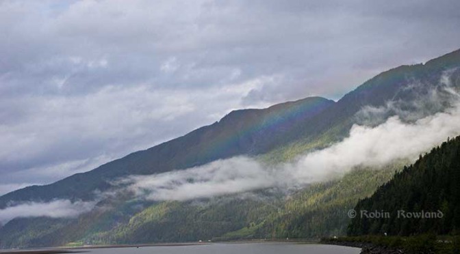
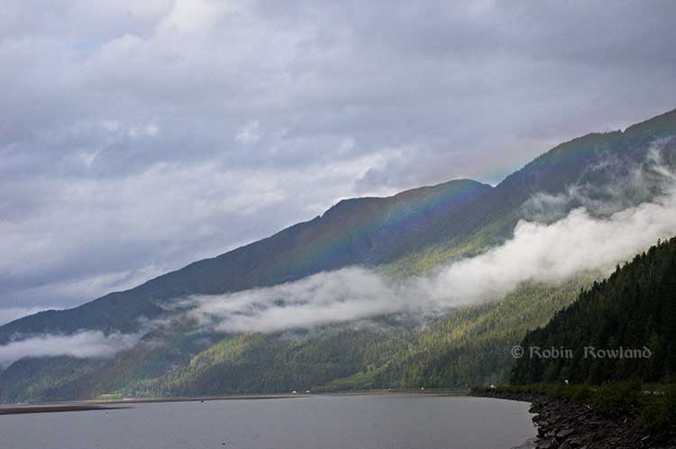
A rainbow hugs the mountains near the Telegraph Point rest area on the Skeena River between Terrace and Prince Rupert, Sept. 29, 2014. Traffic is seen on the narrow corridor between the mountains and the river (Robin Rowland/Northwest Coast Energy News)
Alternatives to Kitimat?
Now the new premier of Alberta, Jim Prentice, who should know better if he’s going to lead that province, is hinting that Kitimat isn’t the only possible solution for the Northern Gateway.
Without specifying Prince Rupert, according to Gary Mason reporting in The Globe and Mail, Prentice was speculating about an alternative to Kitimat.
Asked whether he believes the Gateway terminus should be relocated to Prince Rupert or another destination, Mr. Prentice said, “Everything I’ve heard from the Haisla who live there is they don’t agree with the terminal being in Kitimat.” Is it possible to get First Nations approval if there is no support at the planned terminus site? “It’s pretty tough,” the Premier said.
Prince Rupert has a thriving local fishing industry that employs hundreds of people and is critically important to the local First Nations. He is convinced the community would not be willing to put that at risk.
“Overwhelmingly people in my community are much more comfortable with liquefied natural gas, with wood pellets, with coal, than any oil product,” he said.
The Prince Rupert Port Authority also rejected the idea
A spokesman for the Prince Rupert Port Authority said Wednesday there is currently no room for Enbridge to build at the port even if it wanted to. “We are fully subscribed,” Michael Gurney said. There are two large vacant lots within the port authority’s jurisdiction, but both are locked by other energy companies, earmarked for LNG projects.
So not only is there no room on the road to Prince Rupert, there is no room in Prince Rupert.
Shovel-ready?
Let’s just consider for a moment that if Prince Rupert was the ideal location for the Northern Gateway terminal (which it is not), what would be needed to get the project going today.
The Northern Gateway Joint Review Panel would have be reconstituted or a new JRP created by the National Energy Board. That’s because the bitumen comes from Bruderheim, Alberta, crossing provincial boundaries and thus it’s in federal jurisdiction.
Even under the fast track rules imposed on the NEB by Stephen Harper’s Conservative government, new environmental and social impact studies would be required, starting from scratch. So add another five years of paperwork before a single shovel goes into the ground.
The pipeline would have to cross the traditional territory of First Nations that, so far, have not been part of the negotiations, mostly the Tsimshian First Nation as well as the Nisga’a First Nation which has a treaty establishing local rule over their territory.
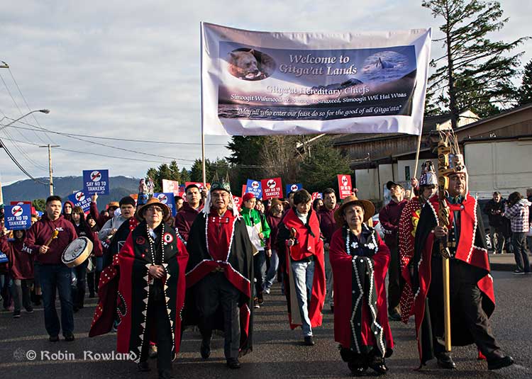
Traditional leaders of the Gitga’at First Nation lead a protest march through the streets of Prince Rupert, February 4, 2012. (Robin Rowland/Northwest Coast Energy News)
In February 2012, the largest anti-Enbridge demonstration outside of the Lower Mainland took place in Prince Rupert, with the elders of the Tsimshian First Nation welcoming the elders and members of the Gitga’at First Nation, at Hartley Bay, which had organized the protest.
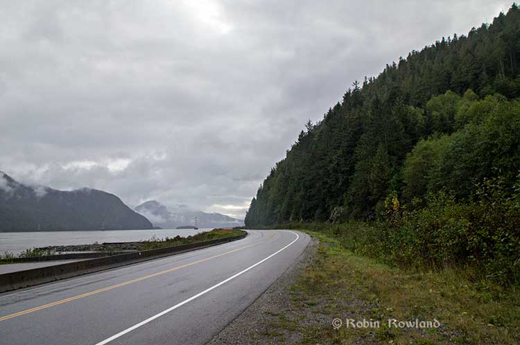
When I say there isn’t room for a pipeline along the Skeena, it also means that there isn’t any room for the pipeline corridor right-of-way. Enbridge, in its submissions to the Joint Review Panel, said it requires a 25 metre wide right of way for the pipeline corridor. (For the record that’s just over 82 feet).
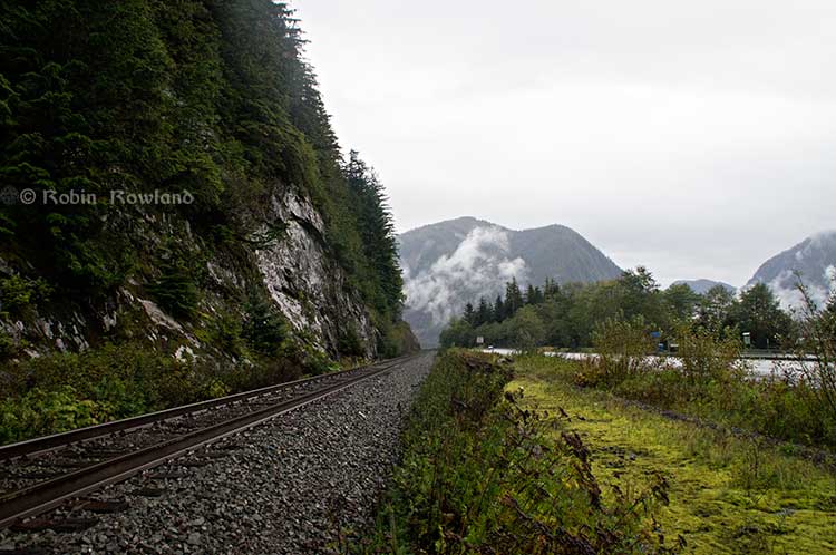
Along that highway, as you will see, there’s barely enough room for the CN mainline and Highway 16 (also known as the Yellowhead Highway) and on a lot of places both the highway and the railway roadbed are built on fill along the side of a cliff.
Albertans’ desperate desire to see the Northern Gateway go to anywhere to what they call “tide water” keeps coming up like the proverbial bad penny. The latest came when Jim Prentice speculated about a new route for the Northern Gateway.
I knew I had an appointment coming up in Prince Rupert on Monday, September 29. So I decided that only way to prove to people sitting in Calgary, Edmonton and Fort McMurray playing with Google Maps that the pipeline to Prince Rupert was a really dumb idea was to shoot photographs to show just why the Northern Gateway will never go to Prince Rupert—at least along the Skeena.
As you drive out of Terrace, you pass two large swing gates (also called by some “Checkpoint Charlie” gates after the Cold War era crossing in Berlin.) At the first rest stop west of Terrace, there are another set of gates at the Exstew. There’s a third set of gates just outside Prince Rupert.
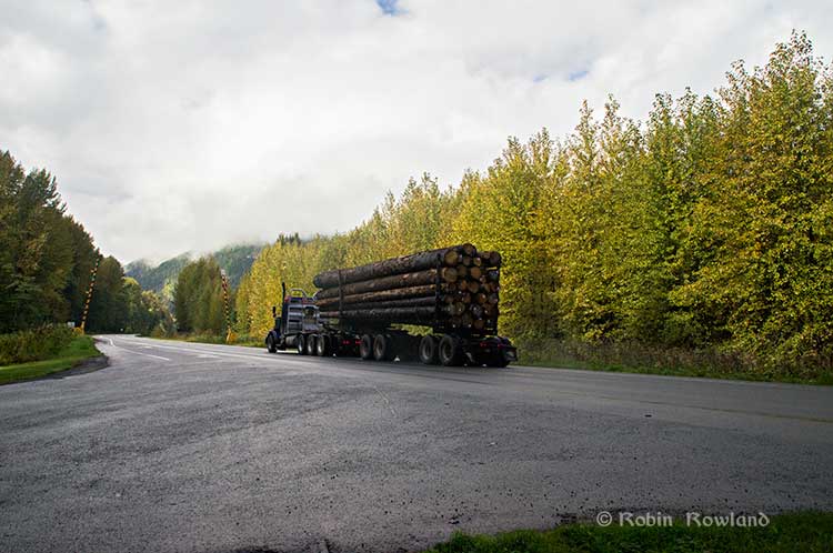
A logging truck passes the avalanche gates at Exstew on Highway 16, Sept. 29, 2014. (Robin Rowland)
The swing gates are avalanche gates and, in the winter, Highway 16 can be shut down if an avalanche closes the highway or the danger from avalanche is too great to allow motorists to proceed. When you drive the highway from Terrace to Prince Rupert in the winter (the signs were covered up when I drove Monday) you are warned “Avalanche danger Next 13 kilometres. No stopping.”
The Exstew avalanche gates, (Robin Rowland/Northwest Coast Energy News)
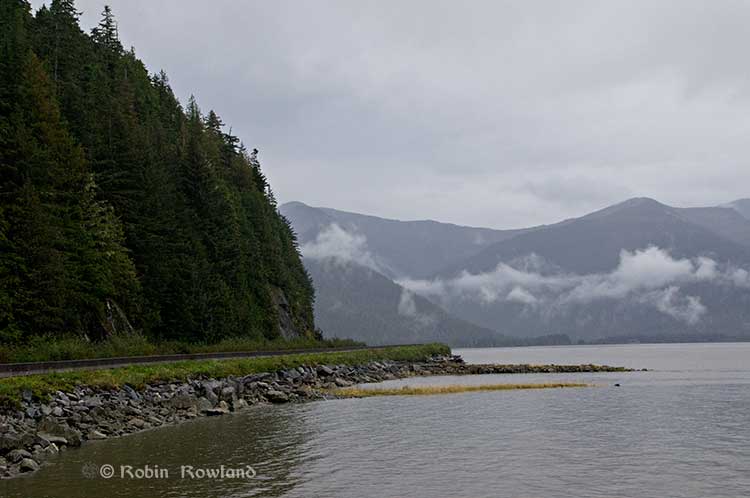
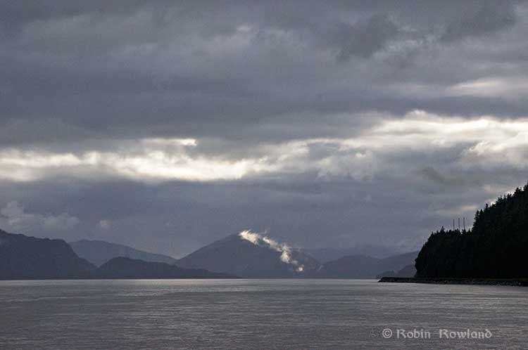
The drive along the Skeena from just west of Exchamsiks River Provincial Park all the way to Tyee where the highway turns inland to reach northwest to Prince Rupert on Kaien Island is one of the most spectacular drives on this planet. The highway snakes along a narrow strip of land with steep mountain cliffs on one side and the vast river on the other.
The problem is that apart from locals and tourists, none of the “experts” whether journalist, think tanker, bureaucrat or politician have, apparently ever driven from Prince Rupert to Terrace.
When both Opposition Leader Tom Mulcair and Liberal Leader Justin Trudeau were in the northwest earlier this summer to “engage” with the local people, apart from short boat trips down Douglas Channel, they flew everywhere. Scheduling you know. Stephen Harper has never visited northwest BC and probably never intends to. His cabinet members fly in for photo ops and then are on the next plane out of town.
Of all the visiting journalists who have come to the northwest only a couple have bothered to drive around the region. Most fly-in fly-out. These days, most often budget-strapped reporters never leave their offices, interviewing the same usual suspects by phone on every story.
On Monday, I took most of the photographs on my way back from Prince Rupert to Terrace after my appointment, so the sequence is from west to east. There are also very few places along the river where you can safely stop. There are concrete barricades on both sides of the highway to prevent vehicles either going into the river or onto the narrow CN right-of-way.
There are, however, two rest stops and a number of small turnoffs on the highway, the turnoffs mainly intended for use by BC Highways, but which are also used by tourists, fishers and photographers.
The first image was taken at one of those highway turnoffs just east of Aberdeen Creek. This is what the highway and rail corridor are like all along the Skeena, the highway, bounded by concrete barricades, the CN rail line and then the towering mountains. Note where the telegraph and telephone lines are—further up the cliffside.
A closer view of the highway and rail corridor just east of Aberdeen Creek.
Here is the view of the Skeena River from the Aberdeen Creek turnoff. You can see to the east, a mountain and the narrow strip of fill land that supports the highway and the rail line.
You see the broad width of the mighty Skeena, the Misty River, as it is called by the Tsimshian First Nation and by everyone else who lives in the northwest and on the right side of the image, the highway and rail corridor built on fill.
Any room for a pipeline?
There’s another turnoff on the other side of the headland east of Aberdeen Creek, looking back the way we came.
The final small turnoff is just by the Kylex River. Again you can see how narrow the highway and rail corridor are.
A few kilometres further along—as I said the highway snakes and curves its way along the riverbank– you come to the Basalt Creek rest area. So this telephoto image shows a logging truck heading west, taken from Basalt Creek, looking back at the highway.
Again you can see both the highway and CN line are built on fill. Is there any room for a pipeline?
Any room for a 25 metre pipeline right-of-way?
Between Basalt Creek and Telegraph Point, a few kilometres to the east, again the highway and rail line hug the narrow strip between the river and mountains.
This shot, taken from Telegraph Point, in October 2013, shows a CN intermodal container train heading to Prince Rupert. The container trains and the coal trains usually have between 150 and 180 cars. If a winter avalanche took out a train, there would be environmental damage, but that damage would be insignificant from coal or containers compared to a train of railbit tankers carrying diluted bitumen.
At Telegraph Point, the second of the three rest stops between Prince Rupert and Terrace, again there is just a narrow strip between the mountain, the highway and the river.
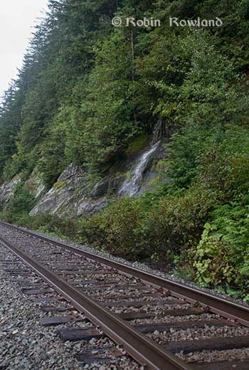
Across the highway from the rest stop, you can again see the narrow corridor, the first shot looking west the rail line close to the cliff face, the second, east, with the waterfall, which you don’t see during the rest of the year, fed by the fall monsoon.
Two shots from the same location, Telegraph Point, taken in March, 2013, of a CN locomotive hauling empty coal cars back to the fields around Tumbler Ridge. (No waterfall in March)
Alternative routes
Everyone has assumed that if Northern Gateway changed its route, the most likely choice given the configuration of the pipeline at the moment is to follow the Skeena.
There are alternatives. The Petronas LNG project and its partner TransCanada Pipelines have proposed a more northern cross-country route, which would go north from the Hazeltons, avoiding the Skeena
If Enbridge wanted to try a northern route, similar to the one TransCanada contemplates for Petronas, Northern Gateway would again run into trouble.
It would require reopening or creating a new Joint Review Panel, many more years of environmental and social impact studies of the route, even under Stephen Harper’s fast track system. The TransCanada/Petronas pipeline would also cross the traditional territory of the Gitxsan First Nation and if Enbridge tried that the company would have to deal with the fact that it signed a controversial agreement with Elmer Derrick that was immediately repudiated by most members of the Gitxsan First Nation and eventually dropped by Enbridge.
So why does this idea of a pipeline to Prince Rupert keep coming up?
In most cases, the idea of the pipeline to Prince Rupert is always proposed by Albertans, not from any credible source in British Columbia, or the suggestions come from desk bound analysts in Toronto and Ottawa both in think tanks and in the newsrooms of dying newspapers who have never seen the Skeena River apart from a tiny handful who have looked at Google Street View
(Yes you can Google Street View Highway 16 along the Skeena, I recommend it if you can’t do the drive)
Perhaps the worst example of this failure of both analysis and journalism came in the Edmonton Journal on July 7,2014, when it published a piece by Bob Russell, entitled Opinion: Make Prince Rupert the terminus, which went over the same old inaccurate arguments.
The overland route currently proposed by Enbridge is fraught with environmental issues because it goes over coastal mountains and streams before entering Kitimat’s port. This port will also be the base of perhaps as many as four liquefied natural gas terminals, which will result in the channel always busy with LNG ships outbound and returning from many Asian ports.
There are existing rights of way for the major highway, the Yellowhead, and CN Rail line from Edmonton to the Port of Prince Rupert, so this eliminates the issue of transgressing First Nations lands. The technical issues of narrow passages can be overcome with engineering. In fact, the pipeline can be buried in the roadway at some restricted locations if absolutely necessary, but two different engineers have assured me that for the most part, the right of way should be able to handle the pipeline. A vital factor, of course, is to reduce the impact by eliminating the need for two pipelines.
The clue is how the Edmonton Journal describes Russell;
Bob Russell has an extensive background in planning and was a member of the Edmonton Metro Regional Planning Commission. He has flown the Douglas Channel, visited Kitimat and toured the Port of Prince Rupert.
This is so typical of the Albertan attitude toward northwest British Columbia, people fly in for a couple of days, make a quick observation, and fly out again and present themselves as experts on the region. (Some “experts” on Kitimat, very active on Twitter have apparently never left Calgary).
It obvious that the “two engineers” who assured him “the right-of-way could handle of pipeline” have no idea what they’re talking about. As the photos show there is barely enough room for a highway and a rail line much less a 25 metre wide pipeline corridor.
If the pipeline was to be built as Russell proposed, the only highway between Prince Rupert and the rest of Canada would have to be closed for years, there are no detours. All so a pipeline can be buried under the asphalt not in solid ground, but in the fill on the side of a riverbank in an avalanche zone?
Of course, closing a highway up here won’t inconvenience anyone in Edmonton or Calgary, will it?
Would CN be happy with years of disruption of their lucrative traffic to Prince Rupert with grain and coal outbound to Asia and all those containers coming in to feed Chinese products to the North American market? (you can be sure Walmart wouldn’t be happy about that, not to mention prairie farmers including those from Alberta)
Russell’s statement
There are existing rights of way for the major highway, the Yellowhead, and CN Rail line from Edmonton to the Port of Prince Rupert, so this eliminates the issue of transgressing First Nations lands.
Is also inaccurate.
I was told by First Nations leaders during the Idle No More demonstrations in the winter of 2013, that, a century ago, when the Grand Trunk built the railway along the Skeena , they did just that, built it without consulting the First Nations along the route, sometime digging up native cemeteries and sacred spots.
While apparently CN has worked in recent years to improve relations with the First Nations along the rail line, according to those leaders some issues of right-of-way remain to be resolved.
If there were any plans to build a diluted bitumen pipeline along that route, that would likely mean another court battle adding to those already before the Federal Court, a court battle that would cost Enbridge, CN, the federal government, environmental NGOs and the First Nations more millions in lawyers’ fees.
It’s doubtful if in the long gone (and perhaps mythical) days of “get it right” journalism that the Russell opinion piece would have passed the scrutiny of an old fashioned copy editor and fact checker.
In 2012, the Edmonton Journal (in a story no longer available on their website) also cited former Alberta Premier Peter Lougheed and former Bank of Canada governor David Dodge, as also favouring Prince Rupert.
Dodge, who was in Edmonton Tuesday to deliver a speech on the global economic outlook at MacEwan University, said Enbridge’s proposed Northern Gateway pipeline to Kitimat looks like even more of a long shot.
“I think the project to Kitimat looks, objectively, more risky. So why hasn’t much greater effort gone into looking at Prince Rupert and taking (bitumen) out that way? My guess is, the easiest place to get B.C. to buy into the project would be to go to Rupert.”
Dodge’s views echo those of former Alberta Premier Peter Lougheed, who also favours looking at an alternate pipeline route to Prince Rupert, where ocean-going supertankers can navigate more easily.
Back in 2012, I finished my piece for the Huffington Post by saying:
So why do people insist, despite the evidence, that the Northern Gateway go to Prince Rupert? It’s no longer an pipeline; it’s emotion and ideology. Ideology in that opposition to the Northern Gateway is seen by conservatives as heretical opposition to free enterprise itself. Emotion among those who see promoting the oil patch as an issue of “Alberta pride” and even Canadian patriotism.
For the promoters of the pipeline to Prince Rupert, ignoring the science of geology and the study of geography across all of northwestern B.C. is no different than repeatedly knocking your head against the Paleozoic metamorphic greenstone of the mountain cliffs along the Skeena. It only gives you a headache.
Things haven’t gotten much better in the past two years. In fact they’re getting worse as opposition to pipelines mounts.
It seems that in 2014 the Alberta and the federal government policy in promoting pipelines Northern Gateway, KinderMorgan’s TransMountain, Keystone XL, Line 9 Reversal and Energy East (slick PR and smiling representatives at open houses, politicians at strictly controlled photo ops) is to ignore facts on the ground and to refuse to deal with the concerns of local people from coast to coast.
There could, perhaps, be a more inclusive and truly science-based pipeline planning process that could see pipelines go on optimum routes but that isn’t happening.
The policy for the oil patch and its politician supporters when it comes to pipelines is facts and geology don’t really matter. So they put on ruby slippers, knock their heels together three times and send pipelines down a yellow brick road to an Emerald City (while telling the locals to ignore the man behind the curtain)
The United States says acidification of the oceans means there is an already growing risk to the northwest coast fishery, including crab and salmon, according to studies released by the National Oceanic and Atmospheric Administration.
As more carbon dioxide is released into the atmosphere and absorbed by the oceans, the water is becoming more acidic and that affects many species, especially shellfish, dissolving the shells.
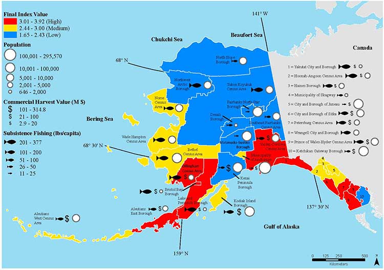
A NOAA study released today of environmental and economic risks to the Alaska fishery says:
Many of Alaska’s nutritionally and economically valuable marine fisheries are located in waters that are already experiencing ocean acidification, and will see more in the near future…. Communities in southeast and southwest Alaska face the highest risk from ocean acidification because they rely heavily on fisheries that are expected to be most affected by ocean acidification…
An earlier NOAA study, released in April, identified a long term threat to the salmon fishery as small ocean snails called pteropods which are a prime food source for pink salmon are already being affected by the acidification of the ocean.
This photograph from NOAA of a pteropod, important in the ocean diet of pink salmon, shows the first evidence of marine snails from the natural environment along the U.S. West Coast with signs that shells are dissolving. (NOAA)
NOAA says:
The term “ocean acidification” describes the process of ocean water becoming more acidic as a result of absorbing nearly a third of the carbon dioxide released into the atmosphere from human sources. This change in ocean chemistry is affecting marine life, particularly the ability of shellfish, corals and small creatures in the early stages of the food chain to build skeletons or shells.
Today’s NOAA study is the first published research by the Synthesis of Arctic Research (SOAR) program, which is supported by an US inter-agency agreement between NOAA’s Office of Oceanic and Atmospheric Research and the Bureau of Ocean Energy Management (BOEM) Alaska Region.
Des Nobles, President of Local #37 Fish [UFAWU-UNIFOR] told Northwest Coast Energy News that the fisheries union and other fisheries groups in Prince Rupert have asked both the Canadian federal and the BC provincial governments for action on ocean acidification. Nobles says so far those requests have been ignored,
Threat to crabs
The studies show that red king crab and tanner crab grow more slowly and don’t survive as well in more acidic waters. Alaska’s coastal waters are particularly vulnerable to ocean acidification because of cold water that can absorb more carbon dioxide and unique ocean circulation patterns which bring naturally acidic deep ocean waters to the surface.
“We went beyond the traditional approach of looking at dollars lost or species impacted; we know these fisheries are lifelines for native communities and what we’ve learned will help them adapt to a changing ocean environment,” said Jeremy Mathis, Ph.D., co-lead author of the study, an oceanographer at NOAA’s Pacific Marine Environmental Laboratory in Seattle, and the director of the University of Alaska Fairbanks School of Fisheries and Ocean Sciences Ocean Acidification Research Center.
As for Dungeness crab, Sarah Cooley, a co-author of the Alaska study, who was with the Woods Hole Oceanographic Institution at the time, told Northwest Coast Energy News, “The studies have not been done for Dungeness crab that have been done for king and tanner crab, that’s something we’re keenly aware of. There’s a big knowledge gap at this point.” She says NOAA may soon be looking at pilot study on Dungeness crab.
A healthy pteropod collected during the U.S. West Coast survey cruise. (NOAA)
Risk to Salmon, Mackerel and Herring
In a 2011-2013 survey, a NOAA-led research team found the first evidence: “that acidity of continental shelf waters off the West Coast is dissolving the shells of tiny free-swimming marine snails, called pteropods, which provide food for pink salmon, mackerel and herring.”
The survey estimated that the percentage of pteropods along the west coast with dissolving shells due to ocean acidification had “doubled in the near shore habitat since the pre-industrial era and is on track to triple by 2050 when coastal waters become 70 percent more corrosive than in the pre-industrial era due to human-caused ocean acidification.”
That study documented the movement of corrosive waters onto the continental shelf from April to September during the upwelling season, when winds bring water rich in carbon dioxide up from depths of about 120 to 180 metres to the surface and onto the continental shelf.
“We haven’t done the extensive amount of studies yet on the young salmon fry,” Cooley said. “I would love to see those studies done. I think there is a real need for that information. Salmon are just so so important for the entire Pacific Northwest and up to Alaska.”
In Prince Rupert, Barb Faggetter, an independent oceanographer whose company Ocean Ecology has consulted for the fisherman’s union and NGOs, who was not part of the study, spoke generally about the threat of acidification to the region.
She is currently studying the impact of the proposed Liquified Natural Gas terminals that could be built at Prince Rupert near the Skeena River estuary. Faggetter said that acidification could affect the species eaten by juvenile salmon. “As young juveniles they eat a lot of zooplankton including crustaceans and shell fish larvae.”
She added, “Any of the shell fish in the fishery, including probably things like sea urchins are all organisms that are susceptible to ocean acidification because of the loss of their capacity to actually incorporate calcium carbonate into their shells.”
Faggetter said her studies have concentrated on potential habitat loss near Prince Rupert as a result of dredging and other activities for liquified natural gas development, She adds that ocean acidification “has been a consideration that climate change will further worsen any potential damage that we’re currently looking at.”
Her studies of the Skeena estuary are concentrating on “rating” areas based on the food supply available to juvenile salmon, as well as predation and what habitat is available and the quality of that habitat to identify areas that “are most important for the juvenile salmon coming out of the Skeena River estuary and which are less important.”
She said that climate change and ocean acidification could impact the Skeena estuary and “probably reduce some of the environments that are currently good because they have a good food supply. If ocean acidification reduces that food supply that will no longer be good habitat for them” [juvenile salmon].
Bongo nets are deployed up to 200 meters deep to catch marine snails (pteropods), which are indicators of the progress of ocean acidification. The pteropod samples were collected during the U.S. West Coast survey cruises in 2011 and 2013. Unlike the US, Canada’s DFO is using models to track what’s happening to pteropods. (NOAA)
The August 2011 NOAA survey of the pteropods was done at sea using “bongo nets” to retrieve the small snails at depths up to 200 metres. The research drew upon a West Coast survey by the NOAA Ocean Acidification Program in that was conducted on board the R/V Wecoma, owned by the National Science Foundation and operated by Oregon State University.
Nina Bednarsek, Ph.D., of NOAA’s Pacific Marine Environmental Laboratory in Seattle, the lead author of the April pteropod paper said, “Our findings are the first evidence that a large fraction of the West Coast pteropod population is being affected by ocean acidification.
“Dissolving coastal pteropod shells point to the need to study how acidification may be affecting the larger marine ecosystem. These near shore waters provide essential habitat to a great diversity of marine species, including many economically important fish that support coastal economies and provide us with food.”
Ecology and economy
Today’s study on the effects of acidification on the Alaska fishery study examined the potential effects on a state where the fishing industry supports over 100,000 jobs and generates more than $5 billion in annual revenue. Fishery-related tourism also brings in $300 million annually to the state.
A map of Alaska shows the economic and ecological risks to parts of the state from ocean acidification. (NOAA)
The study also shows that approximately 120,000 people or roughly 17 percent of Alaskans rely on subsistence fisheries for most, if not all of their dietary protein. The Alaska subsistence fishery is open to all residents of the state who need it, although a majority of those who participate in the subsistence fishery are Alaska’s First Nations. In that way it is somewhat parallel to Canada’s Food, Ceremonial and Social program for First Nations.
“Ocean acidification is not just an ecological problem—it’s an economic problem,” said Steve Colt, Ph.D., co-author of the study and an economist at the University of Alaska Anchorage. “The people of coastal Alaska, who have always looked to the sea for sustenance and prosperity, will be most affected. But all Alaskans need to understand how and where ocean acidification threatens our marine resources so that we can work together to address the challenges and maintain healthy and productive coastal communities.”
The Alaska study recommends that residents and stakeholders in vulnerable regions prepare for environmental challenge and develop response strategies that incorporate community values and needs.
“This research allows planners to think creatively about ways to help coastal communities withstand environmental change,” said Cooley, who is now science outreach manager at Ocean Conservancy, in Washington, D.C. “Adaptations can be tailored to address specific social and environmental weak points that exist in a community.
“This is really the first time that we’ve been able to go under the hood and really look at the factors that make a particular community in a borough or census are less or more vulnerable from changing conditions resulting from acidification. It gives us a lot of power so that we don’t just look at environmental issues but also look at the social story behind that risk.”
As for the southern part of the Alaska panhandle nearest British Columbia, Cooley said, “What we found is that there is a high relative risk compared to some of the other areas of Alaska and that is because the communities there undertake a lot of subsistence fishing, There tend not be a whole lot of commercial harvests in the fisheries there but they are very very important from a subsistence stand point… And they’re tied to species that we expect to be on the front line of acidification, many of the clam species that are harvested in that area and some of the crab species.”
Long term effects
Libby Jewett, Director of the NOAA Ocean Acidification Program and author of the pteropod study said, “Acidification of our oceans may impact marine ecosystems in a way that threatens the sustainability of the marine resources we depend on.
“Research on the progression and impacts of ocean acidification is vital to understanding the consequences of our burning of fossil fuels.”
“Acidification is happening now,” Cooley said. “We have not yet observed major declines in Alaskan harvested species. In Washington and Oregon they have seen widespread oyster mortality from acidification.
“We don’t have the documentation for what’s happening in Alaska right now but there are a lot of studies staring up right now that will just keep an eye out for that sort of thing, Acidification is going to be continuing progressively over the next decades into the future indefinitely until we really curb carbon dioxide emissions. There’s enough momentum in the system that is going to keep acidification advancing for quite some time.
“What we need to be doing as we cut the carbon dioxide, we need to find ways to strength communities that depend on resources and this study allows us to think differently about that and too really look at how we can strengthen those communities.
Faggetter said. “It’s one more blow to an already complex situation here, My study has been working particularly on eel grass on Flora Bank (pdf) which is a very critical habitat, which is going to be impacted by these potential industrial developments and that impact will affect our juvenile salmon and our salmon fishery very dramatically, that could be further worsened by ocean acidification.”
She said that acidification could also be a long term threat to plans in Prince Rupert to establish a geoduck fishery (pronounced gooey-duck).
The popular large 15 to 20 centimetre clam is harvested in Washington State and southern BC, but so far hasn’t been subject to commercial fishing in the north.
NOAA said today’s study shows that by examining all the factors that contribute to risk, more opportunities can be found to prevent harm to human communities at a local level. Decision-makers can address socioeconomic factors that lower the ability of people and communities to adapt to environmental change, such as low incomes, poor nutrition, lack of educational attainment and lack of diverse employment opportunities.
NOAA’s Ocean Acidification Program and the state of Alaska are also developing tools to help industry adapt to increasing acidity.
The new NOAA study is the first published research by the Synthesis of Arctic Research (SOAR) program. which is supported by an inter-agency agreement between NOAA’s Office of Oceanic and Atmospheric Research and the Bureau of Ocean Energy Management (BOEM) Alaska Region.
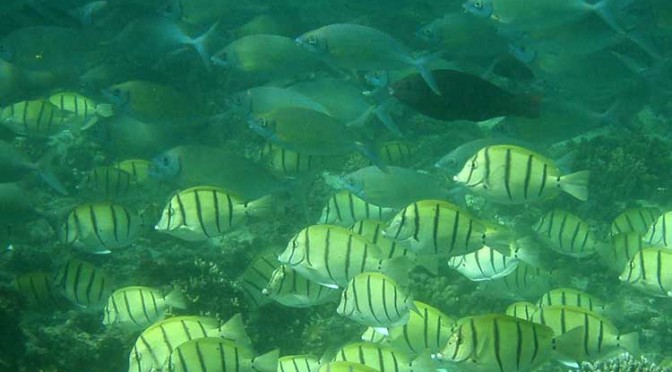
Tropical fish are migrating into what were once temperate water as a result of ocean warming and that poses a serious threat to the areas they invade, because they overgraze on kelp forests and seagrass meadows, according to a new study from the University of New South Wales in Australia
The study says the harmful impact of tropical fish is most evident in southern Japanese waters and the eastern Mediterranean, where there have been dramatic declines in kelps.
A school of tropical plant-eating fish including various species that are shifting their distribution towards temperate waters. (Adriana Verges/UNSW)
There is also emerging evidence in Australia and the US that the spread of tropical fish towards the poles is causing damage in the areas they enter.
“The tropicalisation of temperate marine areas is a new phenomenon of global significance that has arisen because of climate change,” according to the study lead author, Dr. Adriana Verges, of the University of New South Wales.
“Increases in the number of plant-eating tropical fish can profoundly alter ecosystems and lead to barren reefs, affecting the biodiversity of these regions, with significant economic and management impacts.”
The study is published in the journal Proceedings of the Royal Society B.
As the oceans have warmed and the climate has changed, hotspots are developing in regions where the currents that transport warm tropical waters towards the poles are strengthening.
Increased flow of the East Australian Current, for example, has meant waters south-east of the continent are warming at two to three times the global average.
Tropical fish are now common in Sydney Harbour during the summer months.
Japan, the east coast of the US, northern Brazil and south eastern Africa are also strongly influenced by coastal currents that transport warm tropical waters.
“In tropical regions, a wide diversity of plant-eating fish perform the vital role of keeping reefs free of large seaweeds, allowing corals to flourish. But when they intrude into temperate waters they pose a significant threat to these habitats. They can directly overgraze algal forests as well as prevent the recovery of algae that have been damaged for other reasons,” Dr Verges said.
Tropical fish expanding their ranges into temperate areas include unicornfish, parrotfish, and rabbitfish.
The study authors include researchers from Australia, the US, Spain, Singapore, the UK and Japan.
Kelp disappears in southern Japan
The study reports that more than 40 per cent of the kelp and algal beds have disappeared since the 1990s, a phenomenon known in Japan as isoyake.
Tropical species including rabbitfish and parrotfish appear to be mainly responsible.
Although these fish have been present for a long time, their annual grazing rates have increased dramatically as ocean temperatures in winter have risen. Corals now dominate the ecosystem in many locations. The changes have led to the collapse of the abalone fishery.
Rabbit fish expand in eastern Mediterranean
Tropical fish moved into the eastern Mediterranean from the Red Sea after the opening of the Suez Canal. In recent decades, rabbitfish numbers have increased, resulting in hundreds of kilometres of deforested areas and a 40 per cent decrease in the variety of marine species.
As the Mediterranean warms the rabbitfish are expanding their range westward, putting other shallow ecosystems at risk.
Gulf of Mexico
There has been a more than 20-fold increase in the number of parrotfish in the Gulf of Mexico – a species which consumes seagrass at five times the rate of native grazers. The number of plant-eating green turtles and manatees has also increased.
Australia
In Western Australia, emerging evidence suggests that increases in the number of tropical fish are preventing the recovery of kelp forest damaged by a heat wave in 2011.
In eastern Australia, kelp has disappeared from numerous reefs in the past five years and Dr Verges’ research suggests intense grazing by tropical fish on the kelp preceded this.
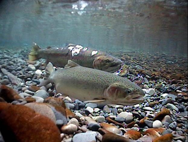
Iron and steel in hatcheries, including rebar supporting concrete structural elements, could be distorting the ability of salmon and trout to navigate using the earth’s magnetic fields according to a study released today by Oregon State University.
The exposure to iron and steel distorts the magnetic field around the young fish, affecting the fish’s “map sense” and their ability to navigate, said Nathan Putman, who led the study while working as a postdoctoral researcher in the Oregon Department of Fisheries and Wildlife, part of OSU’s College of Agricultural Sciences.
For decades, scientists have studied how salmon find their way across vast stretches of ocean.
Spawning Steelhead (Oregon State University).
In a study last year, Putman and other researchers presented evidence of a correlation between the oceanic migration patterns of salmon and drift of the Earth’s magnetic field. They confirmed the ability of salmon to navigate using the magnetic field in experiments at the Oregon Hatchery Research Center.
That earlier research confirmed that fish possess a map sense, determining where they are and which way to swim based on the magnetic fields they encounter.
“The better fish navigate, the higher their survival rate,” said Putman, who conducted the research at the Oregon Hatchery Research Center in the Alsea River basin last year. “When their magnetic field is altered, the fish get confused.”
Subtle differences in the magnetic environment within hatcheries could help explain why some hatchery fish do better than others when they are released into the wild, Putman said.
The study suggests that stabilizing the magnetic field by using alternative forms of hatchery construction may be one way to produce a better yield of fish, he said.
“It’s not a hopeless problem,” he said. “You can fix these kinds of things. Retrofitting hatcheries with non-magnetic materials might be worth doing if it leads to making better fish.”
The new findings follow the earlier research by Putman and others that confirmed the connection between salmon and the Earth’s magnetic field.
Researchers exposed hundreds of juvenile Chinook salmon to different magnetic fields that exist at the latitudinal extremes of their oceanic range.
Fish responded to these “simulated magnetic displacements” by swimming in the direction that would bring them toward the center of their marine feeding grounds.
Putman repeated that experiment with the steelhead trout and achieved similar results. He then expanded the research to determine if changes to the magnetic field in which fish were reared would affect their map sense. One group of fish was maintained in a fiberglass tank, while the other group was raised in a similar tank but in the vicinity of iron pipes and a concrete floor with steel rebar, which produced a sharp gradient of magnetic field intensity within the tank. Iron pipes and steel reinforced concrete are common in fish hatcheries.
The scientists monitored and photographed the juvenile steelhead, called parr, and tracked the direction in which they were swimming during simulated magnetic displacement experiments. The steelhead reared in a natural magnetic field adjusted their map sense and tended to swim in the same direction. But fish that were exposed to the iron pipes and steel-reinforced concrete failed to show the appropriate orientation and swam in random directions.
More research is needed to determine exactly what that means for the fish. The loss of their map sense could be temporary and they could recalibrate their magnetic sense after a period of time, Putman said. Alternatively, if there is a critical window in which the steelhead’s map sense is imprinted, and it is exposed to an altered magnetic field then, the fish could remain confused forever, he said.
“There is evidence in other animals, especially in birds, that either is possible,” said Putman, who now works for the National Oceanic and Atmospheric Administration. “We don’t know enough about fish yet to know which is which. We should be able to figure that out with some simple experiments.”
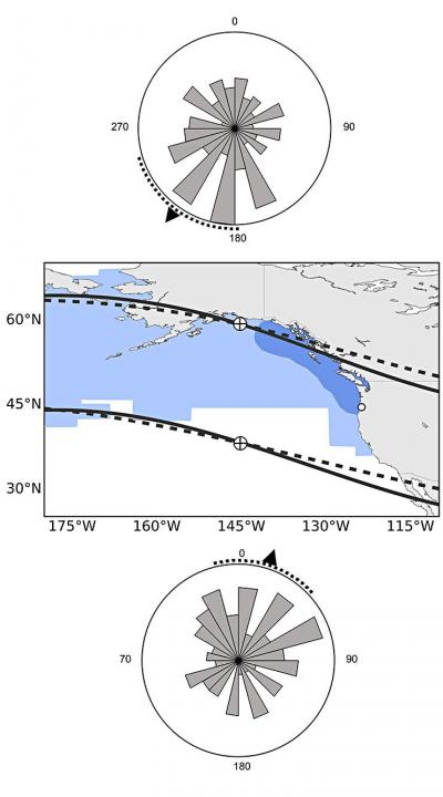
Map showing the ocean range of Chinook salmon and how the fish sense magnetic fields. Fish with a “northern orientation” swim south and vice versa. (Oregon State University)
Putman’s findings were published this week in the journal Biology Letters. The research was funded by Oregon Sea Grant and the Oregon Department of Fish and Wildlife, with support from Oregon State University. Co-authors of the study are OSU’s David Noakes, senior scientist at the Oregon Hatchery Research Center, and Amanda Meinke of the Oregon Hatchery Research Center.
Zone maps for the North Coast marine draft plan. (MAPP)
District of Kitimat Council has urged residents to turn out in large numbers for consideration of the North Coast Draft Marine Plan at the Kitimat Valley Institute Tuesday, May 13, from 5:30 to 8:30.
In introducing the motion, Mayor Joanne Monaghan said she was worried that not enough Kitimatians, especially charter operators, boaters and fishers were aware of the meeting.
Another council member privately said he was worried that the Open House and Forum weren’t publicized enough so that the town could be checked off as having “been consulted.”
MAPP stands for Marine Planning Partnership for the North Pacific Ocean.
According to the documents the purpose of the North Coast Marine Plan “is to provide recommendations for achieving a sustainable balance between ecosystem health, social and cultural well-‐being and economic development through an ecosystem-‐based approach to planning and management.”
The plan is all about managing “common First Nation and provincial interests related to marine areas.”
The parners include the province and the Skeena First Nations Stewardship Society (NCSFNSS), representing the Metlakatla, Kitsumkalum, Kitselas, Haisla, Gitga’at, and Gitxaala Nations.
According to the doucments the North Coast plan area covers 27,000 kilometres of coastline;
that is indented with deep fjords and dotted with thousands of islands. It is a region of profound beauty, significant ecological diversity and remarkable cultural richness. Prince Rupert, Terrace and Kitimat are the largest communities in the North Coast plan area, which supports an overall population of approximately 42,000.
According to the summary of the plan:
The physical complexity of the North Coast includes a range of ecosystem types, including important estuaries that support distinct marine ecosystems and species. A diverse range of economic and community activities occur within the North Coast plan area. Commercial fisheries and associated processing facilities and logging have supported communities along the coast since the early 1900s. These activities continue to be important to the well-‐being of coastal communities. Port activities centered around the communities of Prince Rupert, Kitimat and Stewart, and active recreational fishing and tourism sectors, continue to be strong economic drivers in the area. North Coast First Nations living in the region have distinct cultural and spiritual heritages that are intricately linked to the marine environment and the long-‐standing sustainable use and management of marine resources.
The plan appears to overlap some areas where there have been environmental assessments of the Northern Gateway and the numerous liquified natural gas proposals.
The plan summary goes on to say:
The draft plan brings together science and Aboriginal knowledge, input from the technical staff of NCSFNSS (representing the Gitga’at, Gitxaała, Metlakatla, Kitsumkalum, Kitselas and Haisla Nations) and the Province. Key information and direction was provided by First Nations strategic marine use plans and existing provincial planning and policy documents.
Ecological, cultural and social and economic data sources were compiled and analysed by the joint technical team and contract support. Relevant background scientific reports and technical documents from the Pacific North Coast Integrated Management Area (PNCIMA) process were also used, along with the BC Marine Conservation Analysis. Additional information was drawn from government reports and publications, academic literature, industry or sector publications, discussions with experts and local knowledge. Advice was also incorporated from the North Coast Marine Plan Advisory Committee and public and stakeholder engagement.
The Pacific North Coast Integrated Management Area process was killed by the Harper government in the fall of 2011 . The decision to kill the PNCIMA was officially for budget reasons, but general speculation at the time was that Harper and then Natural Resources Minister Joe Oliver wanted to kill PNCIMA as one way of ensuring the government could push through the Northern Gateway project. The MAPP program was set up by the province and First Nations as a reaction to Harper’s decision.
It comes down to the idea that Harper will approve Gateway “in the national interest,” count on a vote split between the NDP and Liberals in British Columbia to avoid any consequences to the Conservative majority and then leave it up to Enbridge to actually get the job of building the pipeline and terminal project done.
Mason quotes “ a senior member of Mr. Harper’s government,” and while Mason doesn’t say what part of Canada the source is from, (unlikely in my view the source is from BC) what the member told Mason reveals that the Harper government is still mired in it the Matrix-world that has always governed its policy on Northern Gateway.
The first step, apparently coming in the next few days, is that the Harper government “rigorous” new tanker protocols for traffic along the west coast.
Even if the protocols are new, just who is going to enforce those policies?
Mason says:
Even if Gateway and the Kinder Morgan expansion went ahead, he argued, B.C. would still only see about 60 per cent of the annual oil tanker traffic the neighbouring state of Washington deals with. And yet Washington has an exceptionally clean record when it comes to the safe transport of oil in and out of its harbours – this, he noted, while operating under marine safety regulations that are not as rigorous as the ones Ottawa intends to put in place for the shipment of oil along the West Coast.
There are a lot big problems with that statement.
First, there’s an organization that the Mason’s source may have heard of known as the United States Coast Guard. The United States rigorously enforces its “weak” regulations, while Canada’s Coast Guard is plagued by staff shortages and budget cuts.
Second, the State of Washington also rigorously enforces its environmental regulations, not only on the coast but across the state. I have been told by retired British Columbia forestry and environmental officials (not to mention Fisheries and Oceans) that there are often more state environmental watch dogs in most Washington State counties than in all of northern British Columbia where the Northern Gateway is supposed to be going.
The September 2013, report by the US National Oceanographic and Atmospheric Administration on the export of Canadian bitumen sands through the US shows that the Washington Department of Ecology is working on strengthening regulations for both pipelines and (where it’s in state jurisdiction) tanker traffic. The same report says the state of Alaska Department of Environmental Conservation is updating its plans and possible regulations in anticipation that bitumen filled tanker traffic from Kitimat would come close to the coast en route to Asia.
Third, the coast of northern British Columbia is more rugged and stormy than the waters off Washington.
Who pays?
The one factor that the urban media seems to ignore, is the big question.
Who pays?
Who pays to enforce the 209 conditions that the Joint Review Panel imposed on the Northern Gateway project?
If the Harper government announces new tanker regulations in the coming days, who pays to enforce those regulations?
There were no provisions in the February budget for enforcing the 209 conditions. Rather there were continuing budget cuts to the very departments that the JRP ruled must be involved in the studying, planning, implementation and enforcement of the 209 conditions, Environment Canada, Fisheries and Oceans and Transport Canada.
So while Mason says “The federal government will play its part in meeting the five conditions laid out by the B.C. government for support of the project,” the response must be “Show me the money!”
During the recent plebiscite campaign, Northern Gateway finally revealed its plans for the “super tugs” that will escort tankers along the coast and up Douglas Channel. Owen McHugh, a Northern Gateway emergency manager said, “Adding these four or five tugs to the north coast provides a rescue capability that doesn’t exist in this format. So for any large commercial vessel that is traveling on our coast, this capacity to protect the waters of the north coast.” Those tugs and Northern Gateway’s plans to station teams at small bases along the coast means that the company is, in effect, creating a parallel, private, coast guard on the BC Coast.
What about the Coast Guard itself? The Harper government has been gutting Coast Guard resources along the coast even before it had its majority. It closed and dismantled the Kitsilano Coast Guard station in Vancouver. There is more dependence on the Royal Canadian Marine Search and Rescue volunteers, who have to raise money locally for modern rescue boats which cost up to $750,000. The money that government was “generously” giving to RCMSAR had to be split up to 70 stations in 42 communities along the coast as well as its administrative and training staff.
And speaking of boats, what about Coast Guard vessels on the coast? As the Globe and Mail has reported, the government’s shipbuilding program is already over budget and behind schedule. The aim is Arctic/Offshore Patrol Ships and new destroyers. With the crippling of HMCS Protecteur that has raised the concerns about the already troubled supply ship program.
Does anyone notice what is missing from that list? What’s missing are better Coast Guard vessels just to police all the expected tanker traffic on the west coast (whether LNG or bitumen) and no mention of dedicated spill response vessels, which under the “polluter pay” policy will likely be left to private contractors (and hope that the ships are available at the time of a spill)
How will we know?
Then there is the question of how will people even know if the 209 conditions are being enforced; whether or not the reports demanded by the Joint Review Panel are going be sitting on the National Energy Board server and ignored.
There is every indication, given the government’s obsession with secrecy that until there is a disaster the Canadian public will never know what’s going on. Harper’s muzzling doesn’t just cover government scientists, it covers the lowest level of bureaucrats, as District of Kitimat Council found out when low level DFO bureaucrats refused to appear publicly before council to discuss the risk to the Kitimat River.
So the scenario is, according to Mason’s source
“I think once this decision is made, Enbridge could have shovels in the ground the next day,” the member said. “They are ready to go. This means the First Nations could start realizing profits from this right away, as opposed to the promised profits from LNG, which may never materialize. I think they need to think about that.”
First, as part of the blunders is that the Conservatives have always made is the assumption that eventually the First Nations of British Columbia can be paid off, ignoring the commitment of the First Nations, especially on the coast, to protect the environment that sustained them for thousands of years.
While the LNG market is volatile, the “member” forgets that most of the First Nations of British Columbia have opposed the Northern Gateway since Enbridge first floated the idea in 2001. The current LNG rush didn’t start until after Japan shut down its nuclear power plants after the March 2011 earthquake, The first major anti-Enbridge rally, “The Solidarity Gathering of Nations” was held at Kitamaat Village in May 2010.
Writing off BC
It appears that Conservatives, in their election strategy have already written off Gateway opponents:
Still, there is a raw political calculus that needs to be taken into account. Polls measuring support for the pr.oject in B.C. vary, but generally have shown that anywhere from 55 to 60 per cent of the province opposes Gateway and 40 to 45 per cent support it. Isn’t that enough to scare off a government that needs critical votes in B.C. to win another majority?
“Let’s say 60 per cent are against it,” he said. “And that vote splits between the Liberals and the NDP come the next election. Who are the 40 per cent going to vote for?”
Mason also speculates that Harper will approve Gateway to stick it to Barack Obama and the delays on Keystone XL. As he points out that’s a political, not an economic decision.
There are civil disobedience classes being held across northwestern BC this month. Access to Information requests by the Vancouver Observer revealed increased RCMP surveillance of the anti-Gateway movement. There has always been talk of a “war in the woods” if the pipeline project is forced on an unwilling population.
So it comes down to a question that Mason and the Conservatives are avoiding. Mason’s source says Northern Gateway is crucial to the national interest:
“At the end of the day, you have to do what’s right, not what’s politically expedient,” he said. “You have to ask: What’s in the best interests of all Canadians?”
So given all that will the Harper government leave Enbridge to tough it out on its own?
Highly unlikely.
But will the Harper government, with its bean counting obsession on balancing the budget be willing to pay for all that is needed?
Highly likely.
There’s lots of marine clay along the pipeline route, laid down by ancient oceans. That brings to mind just one word. Quagmire, not just the wet, sticky BC mud but a political quagmire.
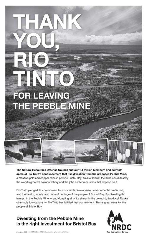
Natural Resources Defence Counsel ad in the Financial Times thanking RIo Tinto (NRDC)
The US based Natural Resources Defence Counsel environmental group, a major opponent of both the Keystone XL and Northern Gateway pipeline projects, is praising Rio Tinto for divesting its interests in the controversial Alaska Pebble Mine project.
The NRDC is, in fact, so pleased, with Rio Tinto that they took out an expensive full page ad in London’s Financial Times to congratulate the mining and smelting giant which, of course, owns Rio Tinto Alcan and the aluminum smelter in Kitimat. Related Rio Tinto donates $19 million Pebble Mine stake to charity
The National Resources Defence Counsel is often a favourite target for the Harper government and oil-patch conservatives who see it as one of the foreign environmental groups interfering in Canadian affairs.
A delegation from the NRDC and Alaska First Nations met with Rio Tinto’s top executives in London, according to a blog post on the organization’s website by Joel Reynolds, its senior lawyer and western director, Pebble Mine: Delivering Congratulations, Not Petitions, to Rio Tinto
In the blog Reynolds writes
We’ve gone each year [to corporate shareholder meetings or to meet corporate executives] to fight the Pebble Mine — a 21st Century example of what the mining industry will do if given free reign, based on promises of safety, sustainability, and technological innovation that can’t be kept and must not be believed….
In 2010, I also traveled to Tokyo to meet with leadership of Mitsubishi Corporation, a former significant Pebble shareholder that quietly sold all of its interest in the project eight months later.
This has become an essential aspect of our advocacy with multi-national corporations: meeting privately with company leadership and participating in the once-a-year public gathering of their shareholders, of which – in order to gain access — we are one. Attending the shareholder meetings is no fun, requiring immersion in a world where natural resources are for extraction and exploitation, where representatives from far-flung communities seeking remediation and redress from contamination recount the tragic impacts of mining on their daily lives.
But this year promised to be different for the residents of Bristol Bay – and for those of us supporting their cause.
NRDC director and lawyer Joel Reynolds shows a copy of the Financial Times ad to Kim Williams, Executive Director of the Alaska Nunamta Aulukestai, Rio Tinto CEO Sam Walsh, Reynolds, Rio Tinto Chair Jan de Plessis, Rio Tinto Director of Copper Jean-Sebastien Jacques and Bobby Andrew, Yupik elder and spokesperson for Nunamta Aulukestai (NRDC)
Reynolds goes on to write that a week after Rio Tinto announced the divestment, they were meeting with RT CEO Sam Walsh and senior executives in the London headquarters:
We were there to thank them for listening to the people of Bristol Bay who, by overwhelming numbers, have consistently voiced their opposition to the mine – a project that embodies the greatest threat ever posed to the economic lifeblood of the region, the Bristol Bay wild salmon fishery.
Each of us in turn – including Bobby Andrew (Yupik elder and spokesperson for Nunamta Aulukestai, an association of Bristol Bay village corporations and tribes; Kim Williams, Executive Director of Nunamta Aulukestai; and Bonnie Gestring, Circuitrider for Earthworks) — delivered a simple message: that Rio Tinto had fulfilled its commitment to Bristol Bay’s communities to act responsibly in a manner consistent with protection of the wild salmon fishery and the wishes of the people who depend on it. Given the scope of the proposed Pebble Mine and the unavoidable risks of contamination associated with its location, there is only one responsible course – divestment – and that is precisely what Rio Tinto had done. The company deserved congratulations, and we conveyed it unequivocally.
Later, meeting with Rio Tinto directors, Reynolds presented the board with a copy of the ad from the Financial Times.
In the blog, Reynolds noted that Vancouver-based Northern Dynasty Minerals is determined to proceed with the project and so the NRDC says “despite major progress against the Pebble project, our work isn’t done, and we remain committed to continuing the fight – along with our Members and activists in support of the people of Bristol Bay.”
In taking out the ad, NRDC’s Taryn Kiekow Heimer, Senior Policy Analyst, Marine Mammal Protection Project, said:
NRDC and its 1.4 million members and activists join the people from Bristol Bay, Alaska Natives, commercial fishermen, sportsmen, jewelers, chefs, restaurant and lodge owners, and conservationists in thanking Rio Tinto for showing environmental and financial leadership by divesting from Pebble Mine.
The Haisla Nation and other groups often quoted NRDC studies on pipelines in their presentations before the Northern Gateway Joint Review Panel.
There is more proof that the toxic agents in crude oil are damaging to the development of fish embryos.
A study, “Deepwater Horizon Crude Oil Impacts the Developing Hearts of Large Predatory Pelagic Fish,” to be published on March 25, shows that several Gulf of Mexico fish embryos developed serious defects in heart development following exposure to crude oil from the Deepwater Horizon oil spill.
This study is the first to analyze the effects of the primary toxic agents released from crude oil on several commercially important pelagic fish species that spawn in the Gulf of Mexico.
The research team, which included five researchers from the University of Miami Rosenstiel School of Marine and Atmospheric Science, concluded that, “losses of early life stages were therefore likely for Gulf populations of tunas, amberjack, swordfish, billfish, and other large predators that spawned in oiled surface habitats.”
“This study is the first to understand the impacts of the Deepwater Horizon oil spill on the early life development of commercially important fish in the Gulf of Mexico,” said Daniel Benetti, Rosenstiel School professor of marine affairs and policy and director of the Aquaculture Program. “The findings can be applied to fisheries management questions in marine regions where crude oil extraction is prevalent.”
The study in the March 25 issue in the journal of the Proceedings of the National Academy of Sciences (PNAS), assessed the impacts of polycyclic aromatic hydrocarbons (PAHs), a toxic agent released from crude oil, from Deepwater Horizon oil samples on embryos of bluefin tuna, yellowfin tuna, and amberjack. Embryos were exposed to two different oil samples, one collected from surface skimming operations in the Gulf of Mexico and another from the source pipe attached to the damaged Deepwater Horizon wellhead.
A vast number of the water samples collected at the Deepwater Horizon oil spill site had PAH concentrations exceeding the toxicity thresholds observed in the study, therefore researchers demonstrated the potential for losses of pelagic fish larvae during the 2010 Deepwater Horizon disaster.
“Having access to the aquaculture facility and expertise at The Rosenstiel School positioned our team of UM scientists to address questions regarding the impacts of the 2010 Deep Water Horizon oil spill on these important pelagic top predators.” said Martin Grosell, Maytag professor of ichthyology at The UM Rosenstiel School. “The present study is the first of several on the topic to emerge from efforts by scientists and graduate students at The UM Rosenstiel School.”
This is a mahi-mahi embryo approximately 36 hours post-fertilization. ( John Stieglitz, UM Rosenstiel School of Marine & Atmospheric Science)
The embryos used in the study were collected from research broodstock located at land-based fish hatcheries in Australia and Panama. Test methods were developed and designed by Dr. Grosell and Dr. Benetti’s team at The UM Rosenstiel School’s experimental hatchery facility.
Exposure to each oil type produced virtually identical defects in embryos of all three tested species. For each species, oil exposures caused serious defects in heart development, and abnormalities in cardiac function, indicating crude oil cardiotoxicity. Bluefin tuna showed the highest percentage of larvae with the entire suite of defects, and their populations are currently listed by the IUCN as endangered due to historically low levels.
The Deepwater Horizon oil spill in the northern Gulf of Mexico released more than four million barrels of crude oil into the surrounding waters during the seasonal spawning window for bluefin and yellowfin tunas, mahi mahi, king and Spanish mackerels, greater and lesser amberjack, sailfish, blue marlin, and cobia, all commercially and ecologically important open-ocean fish species.
“Vulnerability assessments in other ocean habitats, including the Arctic, should focus on the developing heart of resident fish species as an exceptionally sensitive and consistent indicator of crude oil impacts,” said the paper’s authors.
A study of an oil spill in San Francisco Bay in 2007 found “unexpected lethal impact on embryonic fish,” according to scientists from the University of California at Davis and the US National Oceanic and Atmospheric Administration who spent two years on follow-up research after the spill.