Chevron Corporation says its wholly-owned subsidiary, Chevron Canada Limited, has reached agreement to sell a 30 per cent interest in its Duvernay shale gas play to Kuwait Foreign Petroleum Exploration Company’s wholly-owned subsidiary, KUFPEC Canada Inc., for $1.5 billion.
The total purchase price includes cash paid at closing as well as a carry of a portion of Chevron Canada’s share of the joint venture’s future capital costs. The Duvernay is located in west-central Alberta, and is believed to be among the most promising shale opportunities in North America.
The agreement creates a partnership for appraisal and development of liquids-rich shale resources in approximately 330,000 net acres in the Kaybob area of the Duvernay.
“This sale demonstrates our focus on strategically managing our portfolio to maximize the value of our global upstream businesses and is consistent with our partnership strategy,” said Jay Johnson, senior vice president, Upstream, Chevron Corporation. “The transaction provides us an expanded relationship with a valued partner. It also recognizes the outstanding asset base we have assembled.”
Following the closing of the transaction, Chevron Canada will hold a 70 percent interest in the joint venture Duvernay acreage and will remain the operator. The transaction is expected to close in November 2014.
“We remain encouraged by the early results of our exploration program and view the Kaybob Duvernay as an exciting growth opportunity for the company,” said Jeff Shellebarger, president of Chevron North America Exploration and Production Company.
Chevron Canada has drilled 16 wells since beginning its exploration program, with initial well production rates of up to 7.5 million cubic feet of natural gas and 1,300 barrels of condensate per day. A pad drilling program recently commenced which is intended to further evaluate and optimize reservoir performance as well as reduce execution costs and cycle time.
There’s a dumb, dumb, really dumb idea that just won’t go away—that Enbridge could solve all its problems if only, if only, it would send the Northern Gateway Pipeline to Prince Rupert.
Enbridge long ago rejected the idea. Before Enbridge updated its website to make Gateway Facts, to make it slick and more attractive, the old website had an FAQ where Enbridge explained why it wasn’t going to Prince Rupert.
Did you consider running the pipeline to Prince Rupert where a major port already exists?
We considered Prince Rupert and Kitimat as possible locations. We carried out a feasibility study that took into account a number of considerations. The study found that the routes to Prince Rupert were too steep to safely run the pipeline, and that Kitimat was the best and safest option available.
Current proposed route for the Northern Gateway pipeline. (Enbridge)
Here in the northwest even the supporters of the Northern Gateway roll their eyes when they hear the old Prince Rupert story come up again and again – and it’s not just because these people support the Kitimat plans for Northern Gateway, it’s because those supporters (not to mention the opponents) have driven along the Skeena from Terrace to Prince Rupert.
There just isn’t any room for a pipeline. It’s a game of centimetres.
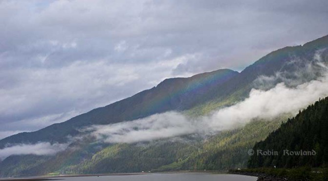
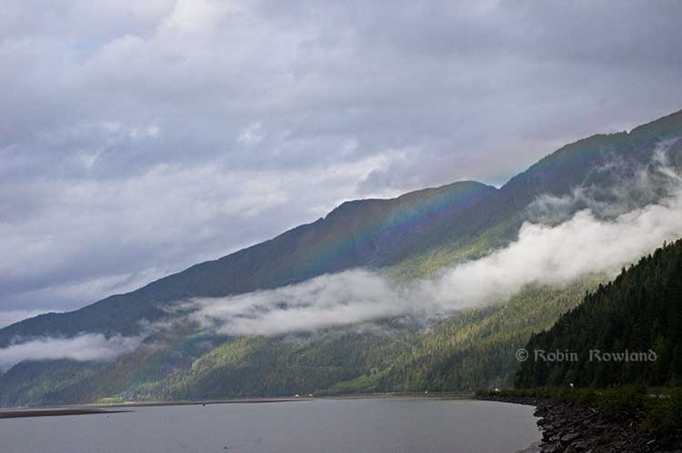
A rainbow hugs the mountains near the Telegraph Point rest area on the Skeena River between Terrace and Prince Rupert, Sept. 29, 2014. Traffic is seen on the narrow corridor between the mountains and the river (Robin Rowland/Northwest Coast Energy News)
Alternatives to Kitimat?
Now the new premier of Alberta, Jim Prentice, who should know better if he’s going to lead that province, is hinting that Kitimat isn’t the only possible solution for the Northern Gateway.
Without specifying Prince Rupert, according to Gary Mason reporting in The Globe and Mail, Prentice was speculating about an alternative to Kitimat.
Asked whether he believes the Gateway terminus should be relocated to Prince Rupert or another destination, Mr. Prentice said, “Everything I’ve heard from the Haisla who live there is they don’t agree with the terminal being in Kitimat.” Is it possible to get First Nations approval if there is no support at the planned terminus site? “It’s pretty tough,” the Premier said.
Prince Rupert has a thriving local fishing industry that employs hundreds of people and is critically important to the local First Nations. He is convinced the community would not be willing to put that at risk.
“Overwhelmingly people in my community are much more comfortable with liquefied natural gas, with wood pellets, with coal, than any oil product,” he said.
The Prince Rupert Port Authority also rejected the idea
A spokesman for the Prince Rupert Port Authority said Wednesday there is currently no room for Enbridge to build at the port even if it wanted to. “We are fully subscribed,” Michael Gurney said. There are two large vacant lots within the port authority’s jurisdiction, but both are locked by other energy companies, earmarked for LNG projects.
So not only is there no room on the road to Prince Rupert, there is no room in Prince Rupert.
Shovel-ready?
Let’s just consider for a moment that if Prince Rupert was the ideal location for the Northern Gateway terminal (which it is not), what would be needed to get the project going today.
The Northern Gateway Joint Review Panel would have be reconstituted or a new JRP created by the National Energy Board. That’s because the bitumen comes from Bruderheim, Alberta, crossing provincial boundaries and thus it’s in federal jurisdiction.
Even under the fast track rules imposed on the NEB by Stephen Harper’s Conservative government, new environmental and social impact studies would be required, starting from scratch. So add another five years of paperwork before a single shovel goes into the ground.
The pipeline would have to cross the traditional territory of First Nations that, so far, have not been part of the negotiations, mostly the Tsimshian First Nation as well as the Nisga’a First Nation which has a treaty establishing local rule over their territory.
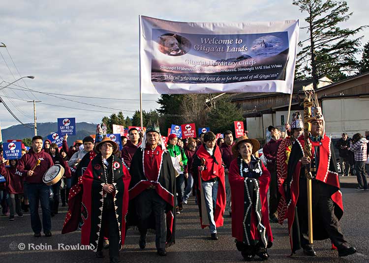
Traditional leaders of the Gitga’at First Nation lead a protest march through the streets of Prince Rupert, February 4, 2012. (Robin Rowland/Northwest Coast Energy News)
In February 2012, the largest anti-Enbridge demonstration outside of the Lower Mainland took place in Prince Rupert, with the elders of the Tsimshian First Nation welcoming the elders and members of the Gitga’at First Nation, at Hartley Bay, which had organized the protest.
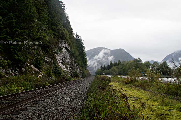
When I say there isn’t room for a pipeline along the Skeena, it also means that there isn’t any room for the pipeline corridor right-of-way. Enbridge, in its submissions to the Joint Review Panel, said it requires a 25 metre wide right of way for the pipeline corridor. (For the record that’s just over 82 feet).
Along that highway, as you will see, there’s barely enough room for the CN mainline and Highway 16 (also known as the Yellowhead Highway) and on a lot of places both the highway and the railway roadbed are built on fill along the side of a cliff.
Albertans’ desperate desire to see the Northern Gateway go to anywhere to what they call “tide water” keeps coming up like the proverbial bad penny. The latest came when Jim Prentice speculated about a new route for the Northern Gateway.
I knew I had an appointment coming up in Prince Rupert on Monday, September 29. So I decided that only way to prove to people sitting in Calgary, Edmonton and Fort McMurray playing with Google Maps that the pipeline to Prince Rupert was a really dumb idea was to shoot photographs to show just why the Northern Gateway will never go to Prince Rupert—at least along the Skeena.
As you drive out of Terrace, you pass two large swing gates (also called by some “Checkpoint Charlie” gates after the Cold War era crossing in Berlin.) At the first rest stop west of Terrace, there are another set of gates at the Exstew. There’s a third set of gates just outside Prince Rupert.
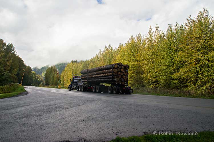
A logging truck passes the avalanche gates at Exstew on Highway 16, Sept. 29, 2014. (Robin Rowland)
The swing gates are avalanche gates and, in the winter, Highway 16 can be shut down if an avalanche closes the highway or the danger from avalanche is too great to allow motorists to proceed. When you drive the highway from Terrace to Prince Rupert in the winter (the signs were covered up when I drove Monday) you are warned “Avalanche danger Next 13 kilometres. No stopping.”
The Exstew avalanche gates, (Robin Rowland/Northwest Coast Energy News)
The drive along the Skeena from just west of Exchamsiks River Provincial Park all the way to Tyee where the highway turns inland to reach northwest to Prince Rupert on Kaien Island is one of the most spectacular drives on this planet. The highway snakes along a narrow strip of land with steep mountain cliffs on one side and the vast river on the other.
The problem is that apart from locals and tourists, none of the “experts” whether journalist, think tanker, bureaucrat or politician have, apparently ever driven from Prince Rupert to Terrace.
When both Opposition Leader Tom Mulcair and Liberal Leader Justin Trudeau were in the northwest earlier this summer to “engage” with the local people, apart from short boat trips down Douglas Channel, they flew everywhere. Scheduling you know. Stephen Harper has never visited northwest BC and probably never intends to. His cabinet members fly in for photo ops and then are on the next plane out of town.
Of all the visiting journalists who have come to the northwest only a couple have bothered to drive around the region. Most fly-in fly-out. These days, most often budget-strapped reporters never leave their offices, interviewing the same usual suspects by phone on every story.
On Monday, I took most of the photographs on my way back from Prince Rupert to Terrace after my appointment, so the sequence is from west to east. There are also very few places along the river where you can safely stop. There are concrete barricades on both sides of the highway to prevent vehicles either going into the river or onto the narrow CN right-of-way.
There are, however, two rest stops and a number of small turnoffs on the highway, the turnoffs mainly intended for use by BC Highways, but which are also used by tourists, fishers and photographers.
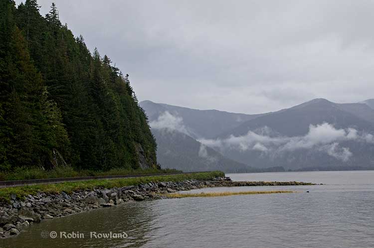
The first image was taken at one of those highway turnoffs just east of Aberdeen Creek. This is what the highway and rail corridor are like all along the Skeena, the highway, bounded by concrete barricades, the CN rail line and then the towering mountains. Note where the telegraph and telephone lines are—further up the cliffside.
A closer view of the highway and rail corridor just east of Aberdeen Creek.
Here is the view of the Skeena River from the Aberdeen Creek turnoff. You can see to the east, a mountain and the narrow strip of fill land that supports the highway and the rail line.
You see the broad width of the mighty Skeena, the Misty River, as it is called by the Tsimshian First Nation and by everyone else who lives in the northwest and on the right side of the image, the highway and rail corridor built on fill.
Any room for a pipeline?
There’s another turnoff on the other side of the headland east of Aberdeen Creek, looking back the way we came.
The final small turnoff is just by the Kylex River. Again you can see how narrow the highway and rail corridor are.
A few kilometres further along—as I said the highway snakes and curves its way along the riverbank– you come to the Basalt Creek rest area. So this telephoto image shows a logging truck heading west, taken from Basalt Creek, looking back at the highway.
Again you can see both the highway and CN line are built on fill. Is there any room for a pipeline?
Any room for a 25 metre pipeline right-of-way?
Between Basalt Creek and Telegraph Point, a few kilometres to the east, again the highway and rail line hug the narrow strip between the river and mountains.
This shot, taken from Telegraph Point, in October 2013, shows a CN intermodal container train heading to Prince Rupert. The container trains and the coal trains usually have between 150 and 180 cars. If a winter avalanche took out a train, there would be environmental damage, but that damage would be insignificant from coal or containers compared to a train of railbit tankers carrying diluted bitumen.
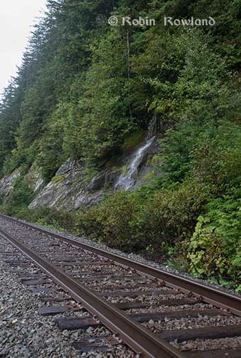
At Telegraph Point, the second of the three rest stops between Prince Rupert and Terrace, again there is just a narrow strip between the mountain, the highway and the river.
Across the highway from the rest stop, you can again see the narrow corridor, the first shot looking west the rail line close to the cliff face, the second, east, with the waterfall, which you don’t see during the rest of the year, fed by the fall monsoon.
Two shots from the same location, Telegraph Point, taken in March, 2013, of a CN locomotive hauling empty coal cars back to the fields around Tumbler Ridge. (No waterfall in March)
Alternative routes
Everyone has assumed that if Northern Gateway changed its route, the most likely choice given the configuration of the pipeline at the moment is to follow the Skeena.
There are alternatives. The Petronas LNG project and its partner TransCanada Pipelines have proposed a more northern cross-country route, which would go north from the Hazeltons, avoiding the Skeena
If Enbridge wanted to try a northern route, similar to the one TransCanada contemplates for Petronas, Northern Gateway would again run into trouble.
It would require reopening or creating a new Joint Review Panel, many more years of environmental and social impact studies of the route, even under Stephen Harper’s fast track system. The TransCanada/Petronas pipeline would also cross the traditional territory of the Gitxsan First Nation and if Enbridge tried that the company would have to deal with the fact that it signed a controversial agreement with Elmer Derrick that was immediately repudiated by most members of the Gitxsan First Nation and eventually dropped by Enbridge.
So why does this idea of a pipeline to Prince Rupert keep coming up?
In most cases, the idea of the pipeline to Prince Rupert is always proposed by Albertans, not from any credible source in British Columbia, or the suggestions come from desk bound analysts in Toronto and Ottawa both in think tanks and in the newsrooms of dying newspapers who have never seen the Skeena River apart from a tiny handful who have looked at Google Street View
(Yes you can Google Street View Highway 16 along the Skeena, I recommend it if you can’t do the drive)
Perhaps the worst example of this failure of both analysis and journalism came in the Edmonton Journal on July 7,2014, when it published a piece by Bob Russell, entitled Opinion: Make Prince Rupert the terminus, which went over the same old inaccurate arguments.
The overland route currently proposed by Enbridge is fraught with environmental issues because it goes over coastal mountains and streams before entering Kitimat’s port. This port will also be the base of perhaps as many as four liquefied natural gas terminals, which will result in the channel always busy with LNG ships outbound and returning from many Asian ports.
There are existing rights of way for the major highway, the Yellowhead, and CN Rail line from Edmonton to the Port of Prince Rupert, so this eliminates the issue of transgressing First Nations lands. The technical issues of narrow passages can be overcome with engineering. In fact, the pipeline can be buried in the roadway at some restricted locations if absolutely necessary, but two different engineers have assured me that for the most part, the right of way should be able to handle the pipeline. A vital factor, of course, is to reduce the impact by eliminating the need for two pipelines.
The clue is how the Edmonton Journal describes Russell;
Bob Russell has an extensive background in planning and was a member of the Edmonton Metro Regional Planning Commission. He has flown the Douglas Channel, visited Kitimat and toured the Port of Prince Rupert.
This is so typical of the Albertan attitude toward northwest British Columbia, people fly in for a couple of days, make a quick observation, and fly out again and present themselves as experts on the region. (Some “experts” on Kitimat, very active on Twitter have apparently never left Calgary).
It obvious that the “two engineers” who assured him “the right-of-way could handle of pipeline” have no idea what they’re talking about. As the photos show there is barely enough room for a highway and a rail line much less a 25 metre wide pipeline corridor.
If the pipeline was to be built as Russell proposed, the only highway between Prince Rupert and the rest of Canada would have to be closed for years, there are no detours. All so a pipeline can be buried under the asphalt not in solid ground, but in the fill on the side of a riverbank in an avalanche zone?
Of course, closing a highway up here won’t inconvenience anyone in Edmonton or Calgary, will it?
Would CN be happy with years of disruption of their lucrative traffic to Prince Rupert with grain and coal outbound to Asia and all those containers coming in to feed Chinese products to the North American market? (you can be sure Walmart wouldn’t be happy about that, not to mention prairie farmers including those from Alberta)
Russell’s statement
There are existing rights of way for the major highway, the Yellowhead, and CN Rail line from Edmonton to the Port of Prince Rupert, so this eliminates the issue of transgressing First Nations lands.
Is also inaccurate.
I was told by First Nations leaders during the Idle No More demonstrations in the winter of 2013, that, a century ago, when the Grand Trunk built the railway along the Skeena , they did just that, built it without consulting the First Nations along the route, sometime digging up native cemeteries and sacred spots.
While apparently CN has worked in recent years to improve relations with the First Nations along the rail line, according to those leaders some issues of right-of-way remain to be resolved.
If there were any plans to build a diluted bitumen pipeline along that route, that would likely mean another court battle adding to those already before the Federal Court, a court battle that would cost Enbridge, CN, the federal government, environmental NGOs and the First Nations more millions in lawyers’ fees.
It’s doubtful if in the long gone (and perhaps mythical) days of “get it right” journalism that the Russell opinion piece would have passed the scrutiny of an old fashioned copy editor and fact checker.
In 2012, the Edmonton Journal (in a story no longer available on their website) also cited former Alberta Premier Peter Lougheed and former Bank of Canada governor David Dodge, as also favouring Prince Rupert.
Dodge, who was in Edmonton Tuesday to deliver a speech on the global economic outlook at MacEwan University, said Enbridge’s proposed Northern Gateway pipeline to Kitimat looks like even more of a long shot.
“I think the project to Kitimat looks, objectively, more risky. So why hasn’t much greater effort gone into looking at Prince Rupert and taking (bitumen) out that way? My guess is, the easiest place to get B.C. to buy into the project would be to go to Rupert.”
Dodge’s views echo those of former Alberta Premier Peter Lougheed, who also favours looking at an alternate pipeline route to Prince Rupert, where ocean-going supertankers can navigate more easily.
Back in 2012, I finished my piece for the Huffington Post by saying:
So why do people insist, despite the evidence, that the Northern Gateway go to Prince Rupert? It’s no longer an pipeline; it’s emotion and ideology. Ideology in that opposition to the Northern Gateway is seen by conservatives as heretical opposition to free enterprise itself. Emotion among those who see promoting the oil patch as an issue of “Alberta pride” and even Canadian patriotism.
For the promoters of the pipeline to Prince Rupert, ignoring the science of geology and the study of geography across all of northwestern B.C. is no different than repeatedly knocking your head against the Paleozoic metamorphic greenstone of the mountain cliffs along the Skeena. It only gives you a headache.
Things haven’t gotten much better in the past two years. In fact they’re getting worse as opposition to pipelines mounts.
It seems that in 2014 the Alberta and the federal government policy in promoting pipelines Northern Gateway, KinderMorgan’s TransMountain, Keystone XL, Line 9 Reversal and Energy East (slick PR and smiling representatives at open houses, politicians at strictly controlled photo ops) is to ignore facts on the ground and to refuse to deal with the concerns of local people from coast to coast.
There could, perhaps, be a more inclusive and truly science-based pipeline planning process that could see pipelines go on optimum routes but that isn’t happening.
The policy for the oil patch and its politician supporters when it comes to pipelines is facts and geology don’t really matter. So they put on ruby slippers, knock their heels together three times and send pipelines down a yellow brick road to an Emerald City (while telling the locals to ignore the man behind the curtain)
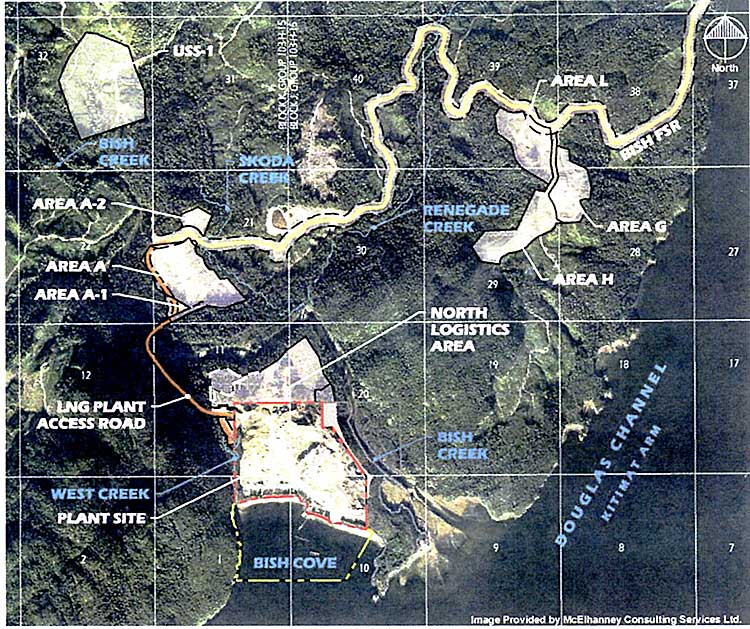
Chevron has applied to the BC Ministry of the Environment for a permit to discharge storm water from the liquified natural gas construction site at Bish Cove and along the shore of Douglas Channel.
The construction site is currently operating on a Waste Water Discharge Approval that expires on Oct. 31.
Map showing construction areas at the Kitimat LNG site at Bish Cove likely to discharge storm water into the Douglas Channel. (Chevron/ McElhanney Consulting)
The application sets new objectives that “will be protective of the receiving environment.” Various construction areas will discharge storm water (likely due to clearing of the bush cover) from areas at Bish Cove itself and the Bish Creek watershed “including the following watercourses and associated tributaries: Bish Creek, West Creek, Skoda Creek and Renegade Creek.”
The application says that the “maximum rate of effluent discharged from this project and support areas will vary based upon seasons and weather.” Areas and amounts of water may change as the construction proceeds. “The characteristics of the stormwater runoff will be water produced from precipitation, including snowmelt that contains suspended sediment from earthworks and construction.” The application adds, “The types of treatment to be applied to the discharges are: erosion prevention and sedimentation control management practices and devices which may include sedimentation ponds, oil water separators, pH adjustment, flocculent addition and sand filtration.
The public and concerned individuals or groups can provide “relevant information” to the Regional Manager, Environmental Protection, #325-1011 Fourth Ave, Prince George BC V2L 3H9 until September 20, 2014 or call Marc Douglas at 844-800-0900.
The cost of Enbridge’s cleanup from the spill at Marshall, Michigan in 2010 is now $1.157 billion the company said Friday as it released its second quarter results. That is an increase of $35 million from the estimates Enbridge released at the end of 2013 and the first quarter of 2014.
As of June, 2014, Enbridge faces possibly $30 million in fines and penalties from the United States government.
In its quarterly report Enbridge said
EEP [Embridge Energy Partners] continues to perform necessary remediation, restoration and monitoring of the areas affected by the Line 6B crude oil release. All the initiatives EEP is undertaking in the monitoring and restoration phase are intended to restore the crude oil release area to the satisfaction of the appropriate regulatory authorities.
On March 14, 2013, as previously reported, the United States Environmental Protection Agency ordered in Enbridge to undertake “additional containment and active recovery of submerged oil relating to the Line 6B crude oil release.”
Enbridge says it has “completed substantially all of the EPA order, “with the exception of required dredging in and around Morrow Lake and its delta.”
“Approximately $30 million of the increase in the total cost estimate during the three months ended June 30, 2014 is primarily related to the finalization of the MDEQ approved Schedule of Work and other costs related to the on-going river restoration activities near Ceresco,” Enbridge reported.
Enbridge also said it is working with the Michigan Department of Environmental Quality “to transition submerged oil reassessment, sheen management and sediment trap monitoring and maintenance activities from the EPA to the MDEQ, through a Kalamazoo River Residual Oil Monitoring and Maintenance Work Plan.”
Enbridge also said that costs may still go up, saying there continues to be the potential for “additional costs in connection with this crude oil release due to variations in any or all of the cost categories, including modified or revised requirements from regulatory agencies, in addition to fines and penalties and expenditures associated with litigation and settlement of claims.”
Enbridge said that “a majority of the costs incurred in connection with the crude oil release for Line 6B are covered by Enbridge’s comprehensive insurance policy…. which had an aggregate limit of $650 million for pollution liability.” So far, Enbridge has recovered $547 million of the $650 million from its insurers. Enbridge is suing its insurers to recover the rest of the money.
That means that “Enbridge and its affiliates have exceeded the limits of their coverage under this insurance policy. Additionally, fines and penalties would not be covered under the existing insurance policy,” the company said.
Insurance renewed
Enbridge said it has “renewed its comprehensive property and liability insurance programs under which the Company is insured through April 30, 2015 with a liability aggregate limit of $700 million, including sudden and accidental pollution liability, with a deductible applicable to oil pollution events of $30 million per event, from the previous $10 million.”
It adds:
In the unlikely event multiple insurable incidents occur which exceed coverage limits within the same insurance period, the total insurance coverage will be allocated among Enbridge entities on an equitable basis based on an insurance allocation agreement among Enbridge and its subsidiaries.
All Enbridge figures are in US dollars
The Northern Gateway Joint Review Panel required Enbridge that “its Northern Gateway’s Financial Assurances Plan must provide a total coverage of $950 million for the costs of liabilities for, without limitation, cleanup, remediation, and other damages caused by the Project during the operations phase. The plan should include the following components and minimum coverage levels.” (That figure in Canadian dollars)
The United States says acidification of the oceans means there is an already growing risk to the northwest coast fishery, including crab and salmon, according to studies released by the National Oceanic and Atmospheric Administration.
As more carbon dioxide is released into the atmosphere and absorbed by the oceans, the water is becoming more acidic and that affects many species, especially shellfish, dissolving the shells.
A NOAA study released today of environmental and economic risks to the Alaska fishery says:
Many of Alaska’s nutritionally and economically valuable marine fisheries are located in waters that are already experiencing ocean acidification, and will see more in the near future…. Communities in southeast and southwest Alaska face the highest risk from ocean acidification because they rely heavily on fisheries that are expected to be most affected by ocean acidification…
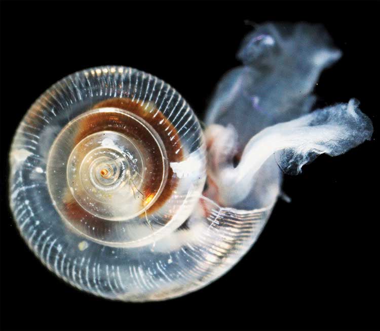
An earlier NOAA study, released in April, identified a long term threat to the salmon fishery as small ocean snails called pteropods which are a prime food source for pink salmon are already being affected by the acidification of the ocean.
This photograph from NOAA of a pteropod, important in the ocean diet of pink salmon, shows the first evidence of marine snails from the natural environment along the U.S. West Coast with signs that shells are dissolving. (NOAA)
NOAA says:
The term “ocean acidification” describes the process of ocean water becoming more acidic as a result of absorbing nearly a third of the carbon dioxide released into the atmosphere from human sources. This change in ocean chemistry is affecting marine life, particularly the ability of shellfish, corals and small creatures in the early stages of the food chain to build skeletons or shells.
Today’s NOAA study is the first published research by the Synthesis of Arctic Research (SOAR) program, which is supported by an US inter-agency agreement between NOAA’s Office of Oceanic and Atmospheric Research and the Bureau of Ocean Energy Management (BOEM) Alaska Region.
Des Nobles, President of Local #37 Fish [UFAWU-UNIFOR] told Northwest Coast Energy News that the fisheries union and other fisheries groups in Prince Rupert have asked both the Canadian federal and the BC provincial governments for action on ocean acidification. Nobles says so far those requests have been ignored,
Threat to crabs
The studies show that red king crab and tanner crab grow more slowly and don’t survive as well in more acidic waters. Alaska’s coastal waters are particularly vulnerable to ocean acidification because of cold water that can absorb more carbon dioxide and unique ocean circulation patterns which bring naturally acidic deep ocean waters to the surface.
“We went beyond the traditional approach of looking at dollars lost or species impacted; we know these fisheries are lifelines for native communities and what we’ve learned will help them adapt to a changing ocean environment,” said Jeremy Mathis, Ph.D., co-lead author of the study, an oceanographer at NOAA’s Pacific Marine Environmental Laboratory in Seattle, and the director of the University of Alaska Fairbanks School of Fisheries and Ocean Sciences Ocean Acidification Research Center.
As for Dungeness crab, Sarah Cooley, a co-author of the Alaska study, who was with the Woods Hole Oceanographic Institution at the time, told Northwest Coast Energy News, “The studies have not been done for Dungeness crab that have been done for king and tanner crab, that’s something we’re keenly aware of. There’s a big knowledge gap at this point.” She says NOAA may soon be looking at pilot study on Dungeness crab.
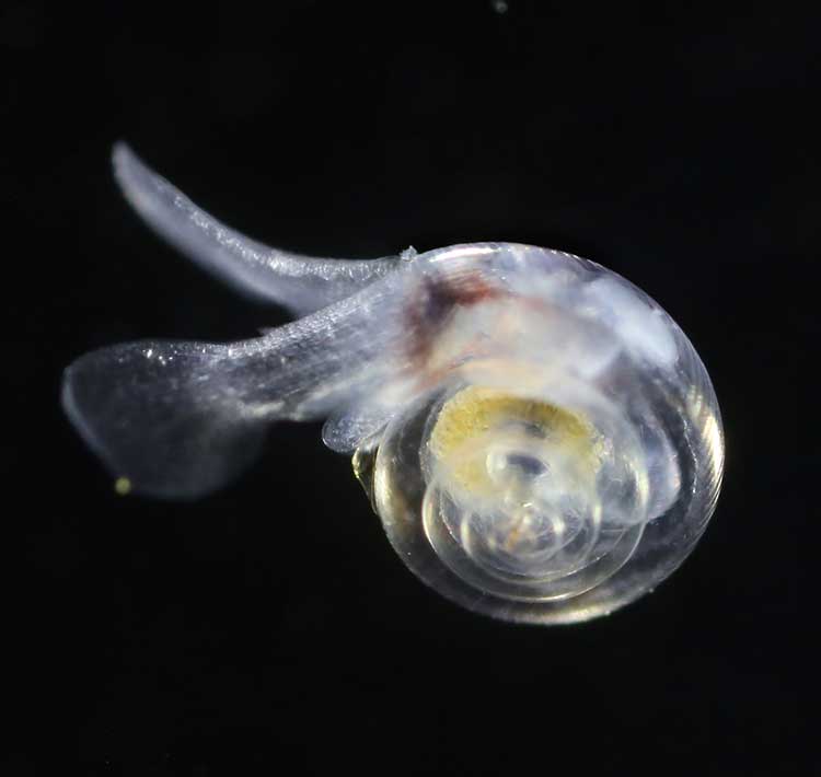
A healthy pteropod collected during the U.S. West Coast survey cruise. (NOAA)
Risk to Salmon, Mackerel and Herring
In a 2011-2013 survey, a NOAA-led research team found the first evidence: “that acidity of continental shelf waters off the West Coast is dissolving the shells of tiny free-swimming marine snails, called pteropods, which provide food for pink salmon, mackerel and herring.”
The survey estimated that the percentage of pteropods along the west coast with dissolving shells due to ocean acidification had “doubled in the near shore habitat since the pre-industrial era and is on track to triple by 2050 when coastal waters become 70 percent more corrosive than in the pre-industrial era due to human-caused ocean acidification.”
That study documented the movement of corrosive waters onto the continental shelf from April to September during the upwelling season, when winds bring water rich in carbon dioxide up from depths of about 120 to 180 metres to the surface and onto the continental shelf.
“We haven’t done the extensive amount of studies yet on the young salmon fry,” Cooley said. “I would love to see those studies done. I think there is a real need for that information. Salmon are just so so important for the entire Pacific Northwest and up to Alaska.”
In Prince Rupert, Barb Faggetter, an independent oceanographer whose company Ocean Ecology has consulted for the fisherman’s union and NGOs, who was not part of the study, spoke generally about the threat of acidification to the region.
She is currently studying the impact of the proposed Liquified Natural Gas terminals that could be built at Prince Rupert near the Skeena River estuary. Faggetter said that acidification could affect the species eaten by juvenile salmon. “As young juveniles they eat a lot of zooplankton including crustaceans and shell fish larvae.”
She added, “Any of the shell fish in the fishery, including probably things like sea urchins are all organisms that are susceptible to ocean acidification because of the loss of their capacity to actually incorporate calcium carbonate into their shells.”
Faggetter said her studies have concentrated on potential habitat loss near Prince Rupert as a result of dredging and other activities for liquified natural gas development, She adds that ocean acidification “has been a consideration that climate change will further worsen any potential damage that we’re currently looking at.”
Her studies of the Skeena estuary are concentrating on “rating” areas based on the food supply available to juvenile salmon, as well as predation and what habitat is available and the quality of that habitat to identify areas that “are most important for the juvenile salmon coming out of the Skeena River estuary and which are less important.”
She said that climate change and ocean acidification could impact the Skeena estuary and “probably reduce some of the environments that are currently good because they have a good food supply. If ocean acidification reduces that food supply that will no longer be good habitat for them” [juvenile salmon].
Bongo nets are deployed up to 200 meters deep to catch marine snails (pteropods), which are indicators of the progress of ocean acidification. The pteropod samples were collected during the U.S. West Coast survey cruises in 2011 and 2013. Unlike the US, Canada’s DFO is using models to track what’s happening to pteropods. (NOAA)
The August 2011 NOAA survey of the pteropods was done at sea using “bongo nets” to retrieve the small snails at depths up to 200 metres. The research drew upon a West Coast survey by the NOAA Ocean Acidification Program in that was conducted on board the R/V Wecoma, owned by the National Science Foundation and operated by Oregon State University.
Nina Bednarsek, Ph.D., of NOAA’s Pacific Marine Environmental Laboratory in Seattle, the lead author of the April pteropod paper said, “Our findings are the first evidence that a large fraction of the West Coast pteropod population is being affected by ocean acidification.
“Dissolving coastal pteropod shells point to the need to study how acidification may be affecting the larger marine ecosystem. These near shore waters provide essential habitat to a great diversity of marine species, including many economically important fish that support coastal economies and provide us with food.”
Ecology and economy
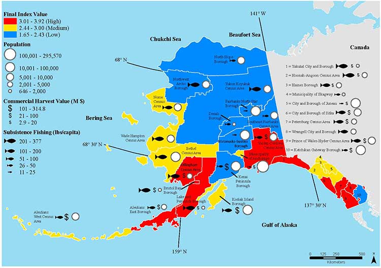
Today’s study on the effects of acidification on the Alaska fishery study examined the potential effects on a state where the fishing industry supports over 100,000 jobs and generates more than $5 billion in annual revenue. Fishery-related tourism also brings in $300 million annually to the state.
A map of Alaska shows the economic and ecological risks to parts of the state from ocean acidification. (NOAA)
The study also shows that approximately 120,000 people or roughly 17 percent of Alaskans rely on subsistence fisheries for most, if not all of their dietary protein. The Alaska subsistence fishery is open to all residents of the state who need it, although a majority of those who participate in the subsistence fishery are Alaska’s First Nations. In that way it is somewhat parallel to Canada’s Food, Ceremonial and Social program for First Nations.
“Ocean acidification is not just an ecological problem—it’s an economic problem,” said Steve Colt, Ph.D., co-author of the study and an economist at the University of Alaska Anchorage. “The people of coastal Alaska, who have always looked to the sea for sustenance and prosperity, will be most affected. But all Alaskans need to understand how and where ocean acidification threatens our marine resources so that we can work together to address the challenges and maintain healthy and productive coastal communities.”
The Alaska study recommends that residents and stakeholders in vulnerable regions prepare for environmental challenge and develop response strategies that incorporate community values and needs.
“This research allows planners to think creatively about ways to help coastal communities withstand environmental change,” said Cooley, who is now science outreach manager at Ocean Conservancy, in Washington, D.C. “Adaptations can be tailored to address specific social and environmental weak points that exist in a community.
“This is really the first time that we’ve been able to go under the hood and really look at the factors that make a particular community in a borough or census are less or more vulnerable from changing conditions resulting from acidification. It gives us a lot of power so that we don’t just look at environmental issues but also look at the social story behind that risk.”
As for the southern part of the Alaska panhandle nearest British Columbia, Cooley said, “What we found is that there is a high relative risk compared to some of the other areas of Alaska and that is because the communities there undertake a lot of subsistence fishing, There tend not be a whole lot of commercial harvests in the fisheries there but they are very very important from a subsistence stand point… And they’re tied to species that we expect to be on the front line of acidification, many of the clam species that are harvested in that area and some of the crab species.”
Long term effects
Libby Jewett, Director of the NOAA Ocean Acidification Program and author of the pteropod study said, “Acidification of our oceans may impact marine ecosystems in a way that threatens the sustainability of the marine resources we depend on.
“Research on the progression and impacts of ocean acidification is vital to understanding the consequences of our burning of fossil fuels.”
“Acidification is happening now,” Cooley said. “We have not yet observed major declines in Alaskan harvested species. In Washington and Oregon they have seen widespread oyster mortality from acidification.
“We don’t have the documentation for what’s happening in Alaska right now but there are a lot of studies staring up right now that will just keep an eye out for that sort of thing, Acidification is going to be continuing progressively over the next decades into the future indefinitely until we really curb carbon dioxide emissions. There’s enough momentum in the system that is going to keep acidification advancing for quite some time.
“What we need to be doing as we cut the carbon dioxide, we need to find ways to strength communities that depend on resources and this study allows us to think differently about that and too really look at how we can strengthen those communities.
Faggetter said. “It’s one more blow to an already complex situation here, My study has been working particularly on eel grass on Flora Bank (pdf) which is a very critical habitat, which is going to be impacted by these potential industrial developments and that impact will affect our juvenile salmon and our salmon fishery very dramatically, that could be further worsened by ocean acidification.”
She said that acidification could also be a long term threat to plans in Prince Rupert to establish a geoduck fishery (pronounced gooey-duck).
The popular large 15 to 20 centimetre clam is harvested in Washington State and southern BC, but so far hasn’t been subject to commercial fishing in the north.
NOAA said today’s study shows that by examining all the factors that contribute to risk, more opportunities can be found to prevent harm to human communities at a local level. Decision-makers can address socioeconomic factors that lower the ability of people and communities to adapt to environmental change, such as low incomes, poor nutrition, lack of educational attainment and lack of diverse employment opportunities.
NOAA’s Ocean Acidification Program and the state of Alaska are also developing tools to help industry adapt to increasing acidity.
The new NOAA study is the first published research by the Synthesis of Arctic Research (SOAR) program. which is supported by an inter-agency agreement between NOAA’s Office of Oceanic and Atmospheric Research and the Bureau of Ocean Energy Management (BOEM) Alaska Region.
1. Why was the study suddenly released after the province said it was “privileged?”
2. Did the apparently rushed release mean that the study, as far as the public is concerned, is incomplete?
3. While most people in Kitimat believed that the study would be a wide ranging look at all parameters of industrial development in the valley, it was limited to just two factors, sulphur dioxide and nitrogen dioxide.
4. It appears that everyone involved were consulted prior to the release with one key execption, the District of Kitimat. Why?
5. The study appears to have changed in its criterion from the time of the request for proposal and the final release one issue—an oil export terminal, which went from “crude” in the request for proposal to refined in the final report.
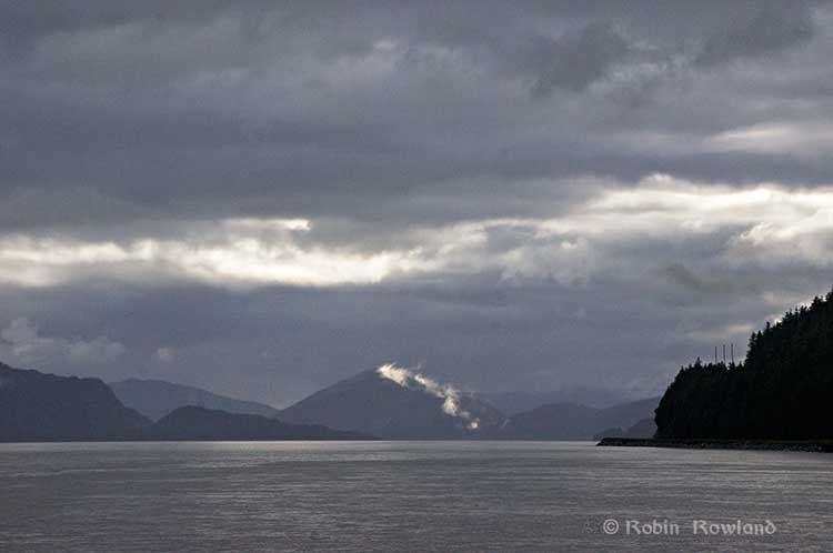
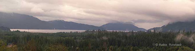
Clouds over Douglas Channel. (Robin Rowland/Northwest Coast Energy News)`
While the study is spun has a showing that industrial development in the Kitimat Valley can proceed as long as the environment is properly managed, the gaps and the spin will likely bring doubt to the results. That means that a wider ranging and truly independent study of the air shed is needed so that both residents and industry can then make the proper decisions.
In October 2013, the Ministry of the Environment issues a “request for proposal” to “study potential cumulative effects to environment and human health from existing and proposed industrial facilities in the Kitimat airshed.” to be filed by March 31, 2014.
The Province will fund a $650,000 scientific study to help inform regulatory and policy development for future industrial activity in the Kitimat area. The goal is to ensure the potential impacts from industrial air emissions are clearly understood prior to new projects being approved and in operation.
The Kitimat Airshed Impact Assessment Project will look at the cumulative effects of existing and proposed industrial air emissions in the airshed. These include emissions from: an existing aluminium smelter, three proposed LNG terminals, a proposed oil refinery, a crude-oil export facility, and gas-turbine-powered electrical generation facilities. The study will focus on sulphur dioxide and nitrogen dioxide emissions from these facilities.
The study will assess the impact of emissions through a number of scenarios, including their potential effects on water and soil, as well as on vegetation and human health from direct exposure.
With that news release, it appears that many people assumed that “cumulative effects of existing and proposed industrial air emissions in the air shed,” would include all possible scenarios and contaminants.
The report, when it was released on Friday, covered just the “focus” sulphur dioxide and nitrogen dioxide and no other factors in air quality.
Crude or refined oil export?
As Northwest Coast Energy News noted that the report, as released, doesn’t include any references to the Enbridge Northern Gateway project, even though Northern Gateway is a source of “proposed industrial air emissions in the air shed.” The request for proposal also mentions “a crude-oil export facility” but the report as issued concerns a marine terminal for Black’s refinery
The products will be exported via a marine terminal on the Douglas Channel. Projected volumes include 320,000 barrels per day of diesel fuel, 110,000 barrels per day of gasoline and 60,000 barrels per day of jet fuel.
The map in the main report clearly shows that the study concerned the “Kitimat Clean Refinery Port” not a crude oil export facility—in other words likely Enbridge Northern Gateway.
Kitimat excluded
On October 21, 2013, District of Kitimat Council endorsed a motion by former Councillor Corinne Scott:
“The BC Government has recently announced a budget of $650,000 to study the cumulative effects on the air quality due to the proposed industrial development in the District of Kitimat. It would be beneficial to have a representative from the District of Kitimat as an active participant on the committee to provide input and feedback as the study progresses.”
At the time Chief Adminstrative Officer Ron Poole told council that the minister’s office had called and promised to “involve the District.”
At that meeting, Councillor Mary Murphy reported that member were “vocal” at the Union of BC Municpalities that it was essential that Kitimat be involved. Councillors suggested that the study be wide ranging and include emissions already in the area and residual emissions left over from the closed Eurocan and Methaex operations.
The provincial final air shed report makes no mention at all of the District of Kitimat, Eurocan or Methanex.
In April, 2014, after the March 31, reporting deadine, the District and Council had heard nothing from the province. So in April, District Council passed a motion asking for a report on the status of the study.
Crown Privilege
In June, the province refused to release the report to lawyers involved in a suit against the Environmental Assessment Board which is challenging Rio Tinto Alcans’ permit to increase sulphur dixoide emission in the valley. According to the Globe and Mail, Dennis Doyle, a lawyer with the Ministry of the Attorney General, in the RTA suit, wrote to the Environmental Law Centre in Victoria
In a follow-up letter dated June 12, Mr. Doyle said, “On the matter of the Kitimat Airshed Study I am instructed that this report was prepared to guide development of government policy on industrial development in the Kitimat area and to assist the executive council in its ongoing deliberations. It is not a report that was prepared for the Respondent and played no part of the decision-making process for the permit amendment which is now under appeal.”
The EAB told the province to respond to that question by July 18. Instead there was a hastily called news conference and the report was released. However, a close look at the report shows that it was likely rushed to meet the EAB deadine and was incomplete—rather surprising for a report that was supposed to be complete by March 31.
Rushed report
What evidence is there that the report was rushed out by the Ministry of the Environment? The most compelling indication is that instead of a public-friendly Summary Report with an executive summary and clear conclusions, there was nothing more than a short Power Point presentation.
Most people in Kitimat who follow the energy debate are familiar with the approach of combining a readable summary with technical data. It is most evident in the report of the Enbridge Northern Gateway Joint Review, which issued a relative short summary, Connections along with the long technical report, Considerations.
Let’s take as a prime example, the original report on the Kitimat airshed commissioned by Rio Tinto Alcan. In that case, ESSA Technologies Ltd of Vancouver, the company hired by the RTA Kitimat Modernization Project to study the effects of increased sulphur dioxide emissions in the Kitimat Valley, issued three documents, an easy to understand 37-page summary report, a much longer 456 page Technical Assessment Report and a third 332 page volume of appendices, technical data and tables.
It was the same company, ESSA Technologies, that was retained by the province to do the much larger study of the airshed. However, the only public-friendly information was the 16 page highly simplified Power Point presentation.
The ESSA summary report for RTA shows in plain language, the reasons for its conclusions that the increased sulphur dioxide from KMP on human health “is characterized as moderate, an acceptable impact, but in need of closer scrutiny with moderate monitoring.” That report also outlines the limitations and uncertainties of the study.
There was no similar plain language summary released for the overall provincial air shed study, even though it was produced by the same company and came to similar conclusions. To find any limitations or uncertainties in the provincial air shed study you have to do a computer search for those key words.
So it is apparent that intended audience for the report is not really those who live in Kitimat, where over the past five years there is wide knowledge that a summary release along with a technical report is considered a standard procedure.
Kitimat not consulted
At the Friday news conference, reporters asked Environment Minister Mary Polak several times about the delay in releasing the report, and then why it was suddenly released.
In answer to the initial question, Polak said, “We had always intended to release it.” She refused to comment on the claim of cabinet privilege, saying that was the responsibility of government lawyers at the Ministry of the Attorney General. She said that the government had received the March 31 report “by the end of April and “it went through quite a rigorous and thorough review by different agencies… we are satisfied now that the findings have been given the kind of rigorous overview and we’re pleased with what has resulted from that.”
Polak said the Haisla Nation were consulted before the commissioning of the report.
Asked again about who the BC government consulted during the review period, she replied, “There were a number of other groups involved in technical review, so not just Ministry of Environment, you’ll be aware of Northern Health authority, but Ministry of Natural Gas Development, Health Canada, Environment Canada and also specialist reviewers from the Province of Quebec, the University of Helsinki, UBC, also private consultants. Then we spent some time going over and having a technical review with Gitga’at and Coastal Coastal First Nations. So it was a matter of ensuring that we had done the very best review of the work before the occasion on which we released it.”
Which leaves one big question, why was the Province of Quebec and the University of Helsinki consulted and Kitimat, despite requests, was not?
Not in the report, not my department
The provincial government called for a report on the “cumulative effects of existing and proposed industrial air emissions” and noted it would focus “ focus on sulphur dioxide and nitrogen dioxide emissions from these facilities.” It is clear that the report did not go beyond the narrow focus on those two substances.
At the Vancouver news conference, a reporter asked Polak why green house gases were not included.
She replied, “That’s not what this study was intended to look at. This department deals with pollutants and pollution and protecting our environment from it, whereas GHG [green house gas] emissions are dealt with in our department around climate change and climate action. These particular substances have an immediate impact on human health and vegetative health and the receiving environment generally unlike GHGs which are a more global impacted and of course have an impact on climate change. This study only looked at those pollutants sulphur doixide and nitrogen dioxide
Then a second reporter asked here about particulate matter, to which Polak replied, “Coming from the Fraser Valley I am very aware of the impact of particulate matter. Any industrial development that we permit in British Columbia or receives an environmental assessment certificate, particulate matter and the release of particulate matter is one of the things that gets evaluated as we determine whether or not to grant those permits. Or to put stipulations on those permits in order to ensure a reduction or management of particulate matter. That’s where that’s dealt with and we have some pretty good understanding of how that operates. We also have some modelling from this study.
“The reason this study didn’t report on that because we hadn’t asked them to. We specifically wanted to get at the issue of sulphur disoxide and nitrogen dioxide but please do not take frm that because it’s not in the study, it doesn’t get looked at. It simply gets looked at in a different process. In this case it was the understanding of the Kitimat air shed with respect to sulphur dixoide and nitrogen dioxide that we needed to have a better answers and better information.”
In other words, despite what the original proposal said: “The goal is to ensure the potential impacts from industrial air emissions are clearly understood prior to new projects being approved and in operation,” the provincial government is content to wait until the permit phase to consider particulate matter, rather than include particulate matter in the long term planning for the air shed.
And for green house gases, the same attitude seems to apply, either it’s not her department or it will be dealt with sometime in the future.
What’s going on in the air shed?
Although the provincial government has been able to spin that the air shed report clears the way for more industrial development in the region, the report isn’t much help for long term planning for those both for and against industrial development in the valley.
First one has to wonder just how comprehensive was the study, even when it comes to sulphur dioxide and nitrogen dioxide?
The report for Rio Tinto Alcan for just one substance—sulphur dixoide—from one industry—aluminum smelting–led to a 456 page technical report with 332 pages of appendices.
The provincial technical report adds one more substance, nitrogen dioxide, and adds four LNG facilities, an oil refinery, different export terminals for those industries, and two hydro generating stations plus related shipping, including a passing mention of vehicular and train traffic. The new report is 363 pages, including the appendices. (It should be noted that the air shed report does reference some of the information in the RTA report)
The various studies for the Enbridge Northern Gateway, which often contained material on air emissions, included a much longer list of what in industry jargon are called CPOC “chemicals of potential concern,” including chemicals that might be released in trace amounts from the Northern Gateway terminal, but may be of more concern from LNG projects. Who knows unless those substances are studied?
As was required by the Joint Review Panel, Enbridge also studied potential problems from accidental release of air-borne contaminants from the Northern Gateway project. There is no mention of accidental release in the current air shed study.
Although the increase in truck traffic in Kitimat is clearly visible to people who live in the town, the air shed report also speculates that with LNG and a possible refinery, there will also be a significant increase in rail traffic coming into Kitimat, hauled, of course, by diesel locomotives, which the report says is “expected to be conservatively captured within the background concentration adjustment.”
Can the Valley “handle industrial expansion”
Stakeholders in the region from the District of Kitimat to the Gitga’at First Nation to various environmental groups asked for a comprehensive review of what is going to happen in the Kitimat air shed with industrial expansion.
So the answer to the question can the valley “handle industrial expansion” after the flawed and limited report from the provincial government is not “yes,” but “we don’t know yet.”
It appears that the report is part of Christy Clark’s ongoing campaign that LNG will save the provincial economy.
There are two factors the report ignores.
First the energy companies are going to make their final investment decision on cold hard facts, including their own assessment of the potential problems from the air shed, not spin from the provincial government.
Second, until there is a proper air shed study, the First Nations, including the Haisla in Kitimat, the Gitga’at at Hartley Bay, the Kitselas in Terrace will not have solid evidence to make a decision on the details of the LNG or refinery development on their traditional territory and increased ship traffic along the coast and that will come into immediate conflict with the Supreme Court ruling on the Tsilhqot’in decision and the finding that “Whether a particular use is irreconcilable with the ability of succeeding generations to benefit from the land will be a matter to be determined when the issue arises.”
There is a new Orwellian phrase used by both the federal and provincial government. Every report is “independent” and “science-based,” although all they all tend to support the policy of the commissioning agency.
What the Kitimat Valley, Douglas Channel and the Terrace region need is a truly independent and truly science based and truly comprehensive evaluation of the air shed. At the moment, that doesn’t exist. It should whether it comes from industry or if the local governments can find the budget to fund a proper study or some combination of the two.
The long awaited Kitimat air shed study, released by the province Friday, July 17, 2014, says “that with proper management, Kitimat’s ai rshed can safely accommodate new industrial growth” without major affects on either human health or the environment. Link to news release :Study shows Kitimat airshed can handle new industrial development
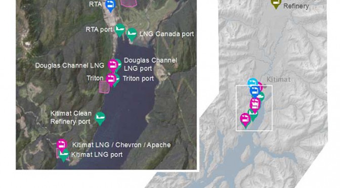
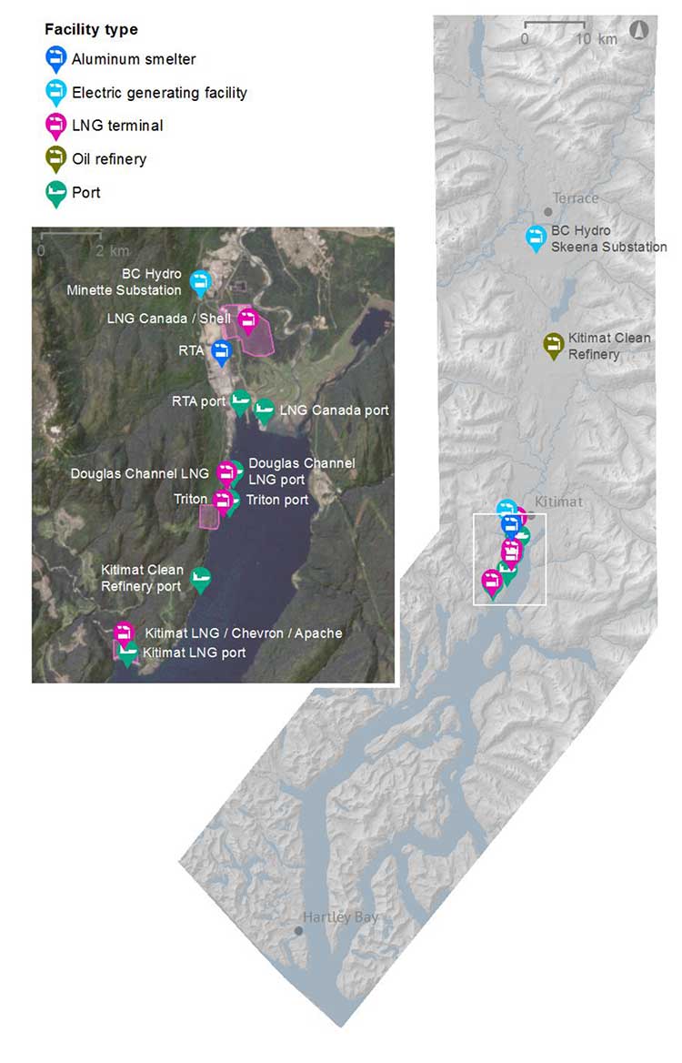
The Kitimat Airshed Assessment looked at the cumulative effects of industrial air emissions, primarily sulphur and nitrogen oxides, and their potential impacts on both human health and the environment from
Rio Tinto Alcan’s existing aluminium smelter and its planned modernization
David Blacks proposed “Kitimat Clean” oil refinery at Onion flats
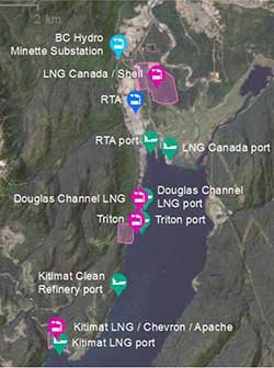
Four proposed LNG facilities; Shell-led LNG Canada, Chevron lead Kitimat LNG, the floating Douglas Channel LNG at the old log dump and a second floating LNG project called Triton.
BC Hydro gas turbine powered electrical generation facilities in Kitimat and near Terrace
Predicted increased to marine shipping in Douglas Channel.
The study was divided into two zones.
Health results were first examined for Kitimat townsite, the Kitimat Industrial Service Centre and Kitamaat Village.
The wider study included Gitga’at Old Town, Hartley Bay (Kulkayu), Kitimat-Stikine, Kitselas, Kitsumkaylum, Kshish, and Terrace.
Enbridge missing
There was one big factor missing from the study, it does not include the Enbridge Northern Gateway project, although the consultants who did the study do cite a couple of the air quality studies that Enbridge filed with the Northern Gateway Joint Review Panel. That despite the fact the Joint Review Panel under Condition 82 required that Enbridge file with the NEB for approval, at least four months prior to commencing construction, “an Air Quality Emissions Management and Soil Monitoring Plan for the Kitimat Terminal.”
The JRP report acknowledged that emissions from the Enbridge terminal would be minimal but would contribute to the cumulative effect of pollutant emissions from other industries and required Enbridge to consult with the District of Kitimat, the environment ministries and other industries in planning for emissions.
The map from the airshed study also shows that the possible marine terminal for David Black’s proposed Kitimat Clean refinery project is at or close to where the proposed Enbridge Northern Gateway terminal would be.
Health and environment
The study looked at proposed emission levels and the effect of emissions elsewhere in the world and then compared those studies with the Kitimat Valley. It found that the risk of sulphur dioxide was “directly related to proximity to industrial area”–largely the Kitimat Service Centre area–and that there would be a minor increase in respiratory incidents of 0.5 per cent to 2 per cent, with a slight increase of nitrogen dioxide but those were within existing guidelines.
As for environmental impact, the study says nitrogen dioxide impacts will be low. There wil be “some increased risk of soil impacts” from sulphur dioxide. The study says there will be “no negative impacts to vegetation across all scenarios” but did find “potential for acidification” of seven small lakes. Lakelese Lake is not one of those affected.
The study also doesn’t include particulate matter and although it does consider climate change, did not take into consideration possible increase of green house gases in the Kitimat Valley.
The consultants, Esssa Technologies of Vancouver, based its findings on an earlier study by Rio Tinto Alcan on emissions from the Kitimat Modernization Project and worked on those findings by adding new industries and a greater area to the models they used.
The province and industry says they will continue to monitor air, water, soil and vegetation “to ensure these values are protected.”
The higher levels of sulphur dioxide emissions from the Rio Tinto Alcan Kitimat Mondernization Project will be allowed to continue under the current permit. Environment Minister Mary Polack told reporters that will only change if the current court challenge to the sulphur dioxide levels are successful.
A map by Essa Technologies and Environment BC of the Kitimat valley airshed study shows locations for existing and proposed industrial or infrastructure development. It does not include the proposed Enbridge Northern Gateway project.
What Northern Gateway Joint Review said about emissions in the air shed
Among the 209 conditions imposed on the Enbridge Northern Gateway project is No. 82, an Air Quality Emissions Management and Soil Monitoring Plan.
Northern Gateway must file with the NEB for approval, at least 4 months prior to commencing construction, an Air Quality Emissions Management and Soil Monitoring Plan for the Kitimat Terminal…
This plan must include:
a) a description of the baseline, pre-construction conditions, informed by relevant modelling results and recent, existing monitor data;
b) locations of both air and soil monitoring sites on a map or diagram, including the rationale for the locations selected and the timing for installation;
c) methods and schedule of ambient monitoring for contaminants of potential concern in air (e.g., NO2, SO2, and H2S) and in soils (e.g., pH; major plant nutrients K, P, N, and S; and trace metals), and emissions source tracking;
d) data recording, assessment, and reporting details;
e) a description of the public communication and complaint response process;
f) additional measures that will be implemented as a result of monitoring data or ongoing concern;
g) the criteria or thresholds that will require implementing additional measures;
h) a description of the plan updating process;
i) a summary of Northern Gateway’s consultation with Environmental Canada and the British Columbia Ministry of Environment regarding the Air Quality Emissions Management and Soil Monitoring Plan. This summary must include any issues or concerns raised regarding the plan and how Northern Gateway has addressed or responded to them; and
j) a summary of discussions with the District of Kitimat and local or regional industrial emitters regarding collaborating on the plan’s design and implementation.
One of the things that the Joint Review Panel noted in requiring Enbridge Northern Gateway to have an updated plan and to collaborate with Kitimat and other industries is that levels of acceptable sulphur doixide in the atmosphere are changing and much of Northern Gateway’s modelling was based on standards that were becoming obsolete.
In the Joint Review Panel report, section 8.7, the JRP said:
Northern Gateway assessed changes in the atmospheric environment, including a modelled assessment of criteria air contaminant, hazardous air pollutant, and greenhouse gas emissions. Criteria air contaminants assessed by modelling included sulphur dioxides, nitrogen oxides, carbon monoxide, hydrogen sulphide, and particulate matter. Hazardous air pollutants were also modelled and included total volatile organic compounds (VOCs), benzene, toluene, ethylbenzene, and xylene (combined, BTEX), as well as hydrogen fluoride.
The provincial air shed report considered only two contaminants, sulphur dioxide and nitrogen dioxide.
Northern Gateway said there would be minimal atmospheric emissions from the construction and operation of the pipeline. The focus was on the Kitimat marine terminal.
The modelled assessment for the Kitimat Terminal included emissions associated with terminal operations, with the largest sources being vehicle traffic and
hydrocarbon storage tanks Northern Gateway used the conservative assumption of continuous ship berthing…emission rate) in order to capture the worst case scenario of concurrent adverse meteorology and maximum potential emissions. From the model results, Northern Gateway predicted that sulphur dioxide associated with operating the Kitimat Terminal would exceed the provincial air quality objectives (Level A) for all time periods. This after mitigation.
Environment Canada said that Northern Gateway took appropriate measures in designing and siting its proposed facilities to minimize adverse effects on air quality. It acknowledged Northern Gateway’s commitments to adopt best practices and to use economically-feasible best-available technologies in designing the Kitimat Terminal to minimize effects on air quality.
Northern Gateway ackknowledged that “due to the project interacting with nearby topographical features, where the largest sulphur dioxide emissions are from the
marine vessels, the highest concentrations were predicted to occur infrequently and immediately adjacent to the terminal fence line.
Northern Gateway, Transport Canada, the Heiltsuk First Nation and other stakeholders did acknowledge that eventually the vessels coming to Kitimat “would be subject to the reduced sulphur fuel requirements associated with the joint United States-Canada North American Emission Control Area.
Based on this, marine fuel sulphur requirements permitted in Canadian coastal waters (200-nautical-mile limit) would be 1.0 per cent in 2012, reducing further to 0.1 per cent by 2015. Northern Gateway predicted that sulphur dioxide emissions from marine vessels should be approximately 96 per cent lower than modelled once these new international fuel standards take effect. Northern Gateway also predicted exceedances of provincial air quality objectives in the area for carbon monoxide, particulate matter, hydrogen sulphide, and total reduced sulphur.
Northern Gateway said there “no exceedances of hazardous air pollutant guidelines were predicted as a result of the project itself” but there could be a cumulative effect with other industries in the Kitimat waterfront.
The Joint Review Panel ruled:
By the Kitimat Terminal’s proposed in-service date, there will have been significant changes to the number and magnitude of existing air emission sources since
the provincial emission inventory of 2000 was compiled, and since Northern Gateway completed its modelling assessment.
Regarding the sulphur emissions attributable to the terminal, marine vessel berthing would account for 97 per cent. Given that Northern Gateway used conservative assumptions regarding berthing in the modelling and that regulations coming into force regarding the sulphur content of marine fuels would further decrease predicted missions, the Panel finds that the modelling results presented in the application and subsequent filings are not predictive of the realistic potential effects on local air quality.
Based on the filed information about sulphur dioxide emissions, the Panel is satisfied that new modelling based on the updated information would indicate that sulphur dioxide associated with the Kitimat Terminal’s operations would not exceed provincial air quality objectives.
The Panel requires that further modelling, reflecting the current level of activity, equipment, and marine sources, must inform Northern Gateway’s design of the Air Quality Emissions Management and Soil Monitoring Plan for the Kitimat Terminal.
Updated modelling would be used to inform the monitoring program’s design, as well as to help ensure that the monitors are placed effectively to monitor both human and environmental health.
Cumulative effects on the atmospheric environment
Northern Gateway said that, during the Kitimat Terminal’s operations, tank maintenance and marine berthing would add a potential measureable contribution to regional cumulative environmental effects from air emissions. Northern Gateway incorporated the existing industrial sources in the Kitimat area in its modelling assessment, using the British Columbia Ministry of Environment’s emissions inventory. At the time the modelling was run, the available emission estimates from 2000 were used to characterize the existing sources in the airshed.
The Joint Review panel noted that over the time of the hearings”it heard of many changes to the industrial make-up of the Kitimat area since the 2000 emissions inventory was developed.”
Combining these with the predicted project emissions, the model results indicated predicted exceedances of regulatory thresholds for sulphur dioxide, carbon monoxide, particulate matter, hydrogen sulphide, and total reduced sulfur, though not at every averaging period.
Northern Gateway said that, due to the existing large emission sources and the region’s complex meteorology and topography, the exceedances are primarily attributable to the other industrial activities around Kitimat and not from the project itself.
Because there would be adverse project effects remaining after mitigation that could combine with the effects of other past, present, and future projects, and because cumulative effects are of primary concern, the Panel’s significance recommendation is given below in its analysis of cumulative effects.
The Panel finds that the emissions associated with the Kitimat Terminal’s operation would be minimal compared to the existing sources presented.
Although the modelled cumulative emissions exceeded many regulatory thresholds, the exceedances were predicted based on an out-of-date emissions inventory, and were predicted to occur prior to adding emissions from the project. Based on the information about sulphur dioxide emissions on the record, in addition to the modelling included in the application, the Panel is satisfied that new modelling based on updated information would indicate that sulphur dioxide associated with the Kitimat Terminal’s operations would not contribute to an increased exceedance of provincial air quality objectives, either through limited emissions or berthing management to limit emissions in particularly adverse conditions.
Tropical fish are migrating into what were once temperate water as a result of ocean warming and that poses a serious threat to the areas they invade, because they overgraze on kelp forests and seagrass meadows, according to a new study from the University of New South Wales in Australia
The study says the harmful impact of tropical fish is most evident in southern Japanese waters and the eastern Mediterranean, where there have been dramatic declines in kelps.
A school of tropical plant-eating fish including various species that are shifting their distribution towards temperate waters. (Adriana Verges/UNSW)
There is also emerging evidence in Australia and the US that the spread of tropical fish towards the poles is causing damage in the areas they enter.
“The tropicalisation of temperate marine areas is a new phenomenon of global significance that has arisen because of climate change,” according to the study lead author, Dr. Adriana Verges, of the University of New South Wales.
“Increases in the number of plant-eating tropical fish can profoundly alter ecosystems and lead to barren reefs, affecting the biodiversity of these regions, with significant economic and management impacts.”
The study is published in the journal Proceedings of the Royal Society B.
As the oceans have warmed and the climate has changed, hotspots are developing in regions where the currents that transport warm tropical waters towards the poles are strengthening.
Increased flow of the East Australian Current, for example, has meant waters south-east of the continent are warming at two to three times the global average.
Tropical fish are now common in Sydney Harbour during the summer months.
Japan, the east coast of the US, northern Brazil and south eastern Africa are also strongly influenced by coastal currents that transport warm tropical waters.
“In tropical regions, a wide diversity of plant-eating fish perform the vital role of keeping reefs free of large seaweeds, allowing corals to flourish. But when they intrude into temperate waters they pose a significant threat to these habitats. They can directly overgraze algal forests as well as prevent the recovery of algae that have been damaged for other reasons,” Dr Verges said.
Tropical fish expanding their ranges into temperate areas include unicornfish, parrotfish, and rabbitfish.
The study authors include researchers from Australia, the US, Spain, Singapore, the UK and Japan.
Kelp disappears in southern Japan
The study reports that more than 40 per cent of the kelp and algal beds have disappeared since the 1990s, a phenomenon known in Japan as isoyake.
Tropical species including rabbitfish and parrotfish appear to be mainly responsible.
Although these fish have been present for a long time, their annual grazing rates have increased dramatically as ocean temperatures in winter have risen. Corals now dominate the ecosystem in many locations. The changes have led to the collapse of the abalone fishery.
Rabbit fish expand in eastern Mediterranean
Tropical fish moved into the eastern Mediterranean from the Red Sea after the opening of the Suez Canal. In recent decades, rabbitfish numbers have increased, resulting in hundreds of kilometres of deforested areas and a 40 per cent decrease in the variety of marine species.
As the Mediterranean warms the rabbitfish are expanding their range westward, putting other shallow ecosystems at risk.
Gulf of Mexico
There has been a more than 20-fold increase in the number of parrotfish in the Gulf of Mexico – a species which consumes seagrass at five times the rate of native grazers. The number of plant-eating green turtles and manatees has also increased.
Australia
In Western Australia, emerging evidence suggests that increases in the number of tropical fish are preventing the recovery of kelp forest damaged by a heat wave in 2011.
In eastern Australia, kelp has disappeared from numerous reefs in the past five years and Dr Verges’ research suggests intense grazing by tropical fish on the kelp preceded this.
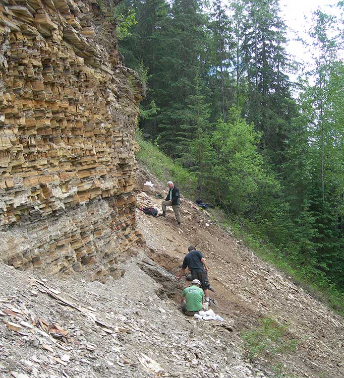
About 52 million years ago what is now the Bulkley Valley was home to a tiny hedgehog and an ancient ancestor of tapirs, who lived on the shores of a placid lake surrounded by a lush upland forest.
The newly discovered fossils at Driftwood Canyon near Smithers are significant advance in the study of the ancient history of the region. That’s because while the Driftwood Canyon Provincial Park is known for beautifully preserved fossils of leaves, fishes and insects, these are the first mammalian remains found at the site.
The fossil hedgehog and tapir are even more significant because at the time they lived near an upland lake, Earth was going through a period of rapid global warming, now called the Paleocene-Eocene Thermal Maximum.
In the past couple of years, climatologists and paleontologists have started to play closer attention to the Thermal Maximum period in hopes of understanding what could happen during climate change today.
Driftwood Canyon first became famous in 1977 with the discovery of oldest known ancestor of salmons, Eosalmo driftwoodensis, which lived in an Eocene lake at Driftwood Canyon.
Today’s study says the ancient hedgehog is a species hitherto unknown to science. It is named Silvacola acares, which means “tiny forest dweller,” since this minute hedgehog likely had a body length of only two to two and half inches or five to six centimetres, about the size of an adult human thumb.
“It is quite tiny and comparable in size to some of today’s shrews,” said Dr. Jaelyn Eberle of the University of Colorado, lead author of the study. She speculated Silvacola may have fed on insects, plants and perhaps seeds.
Did it have quills like contemporary hedgehogs? “We can’t say for sure,” Eberle said. “But there are ancestral hedgehogs living in Europe about the same time that had bristly hair covering them, so it is plausible Silvacola did too.”
The delicate fossil jaw of Silvacola was not freed from the surrounding rock as is typical for fossils. Instead it was studied using an industrial high resolution CT (computed tomography) scanner at Penn State University so it could be studied without risking damage to its tiny teeth.
Hedgehogs are no longer found naturally in North America. Modern hedgehogs and their relatives are restricted to Europe, Asia, and Africa. Hedgehogs have become quite the rage as pets in North America in the past several years. The most common hedgehog pet today is the African pygmy hedgehog, which is up to four times the length of the diminutive Silvacola.
The other mammal, about the size of a medium-sized dog, discovered at the site, is Heptodon, is an ancient relative of modern tapirs, which resemble small rhinos with no horns and a short, mobile, trunk or proboscis.
“Heptodon was about half the size of today’s tapirs, and it lacked the short trunk that occurs on later species and their living cousins. Based upon its teeth, it was probably a leaf-eater, which fits nicely with the rain forest environment indicated by the fossil plants at Driftwood Canyon,” Eberle said.
Most of the fossil-bearing rocks at Driftwood Canyon formed on the bottom of an ancient lake and are well-known for their exceptionally well-preserved leaves, insects, and fishes.
“The discovery in northern British Columbia of an early cousin to tapirs is intriguing because today’s tapirs live in the tropics. Its occurrence, alongside a diversity of fossil plants that indicates a rain forest, supports an idea put forward by others that tapirs and their extinct kin are good indicators of dense forests and high precipitation,” she said.
Forests, lakes, rivers
Fossil plants from the site indicate the area seldom experienced freezing temperatures and probably had a climate similar to that of Portland, Oregon, located roughly 1,126 kilometres or 700 miles to the south.
The current and previous studies have shown the hedgehog and tapid lived on the shores of a lake surrounded by a mixed conifer-broadleaf forest with redwoods, such as Metasequoia and Sequoia, cedars, fir, larch, golden larch, spruce, pine as well as rare ginkgoes. There were also broadleaf deciduous trees such as alder, birch, sassafras, elms, and relatives of the oak family. In the lake were Azolla, a floating fern, which are frequently found as preserved mats in the fossil shale of the cliff at Driftwood, which together with the fine preservation of the insects indicate a quiet water lake.
The remains on the hedgehog were found in the fossil lake bed while the tapir was found in river sediments.
The paleoclimate has been reconstructed suggesting the region had a mean annual temperature of between 10 degrees C and 15 degrees C, with minimal winter freezing and annual precipitation of about 100 centimetres a year. Today, the mean annual temperature for Smithers is 4.2 degrees C with 50.85 centimetres of precipitation a year
Lost world
“Driftwood Canyon is a window into a lost world – an evolutionary experiment where palms grew beneath spruce trees and the insects included a mixture of Canadian and Australian species. Discovering mammals allows us to paint a more complete picture of this lost world,” said Dr. David Greenwood of Brandon University, a co-author of the study.
“The early Eocene is a time in the geological past that helps us understand how present day Canada came to have the temperate plants and animals it has today. However, it can also help us understand how the world may change as the global climate continues to warm.”
The Driftwood Canyon site is the northernmost of a series of Eocene lake sites spanning about 1000 kilometres that reach south from Smithers to Republic in northern Washington that the scientists call the Okanagan Highlands, with a mixture of temperate and tropical plants and animals and a high diversity of insects and plants.
Looting
While Driftwood Canyon is now among sites considered a key indicator of climate change 50 to 53 million years ago, the Harper government has cut almost all the funding for research into paleontology, not just at Driftwood Canyon but across the country, because looking for fossils doesn’t usually fit into the Conservative policy of only funding science that promotes industry.
“Within Canada, the only other fossil localities yielding mammals of similar age are from the Arctic, so these fossils from British Columbia help fill a significant geographic gap,” said Dr. Natalia Rybczynski of the Canadian Museum of Nature, a co-author of the study.
Other fossils of this age come from Wyoming and Colorado, some 4,345 kilometres or 2,700 miles to the south of the Arctic site of Ellesmere Island. In addition, sources have told Northwest Coast Energy News that the provincial budget for Driftwood Canyon, despite its significance, is the same as other small parks of that size, with virtually no security to prevent fossils leaving the park, either in the hands of professional looters or if they are picked up and taken home by visitors.
There are consistent reports that looted fossils from Driftwood Canyon are regularly showing up at fossil shows in the United States.
Sources have told Northwest Coast Energy News that the provincial government has ignored requests to improve security at Driftwood Canyon because it is considered a small (just 21 hectares) low priority park off the main tourist routes, rather than a significant fossil site.
The mammal fossils were discovered in 2012 before the budget cuts and are now in the Royal British Columbia museum in Victoria. The fieldwork was supported by Natural Sciences and Engineering Research Council of Canada.
The study “Early Eocene mammals from the Driftwood Creek beds, Driftwood Canyon Provincial Park, Northern British Columbia ” was published in the July 8, 2014 edition of the Journal of Vertebrate Paleontology.
The fossil-bearing sediments at the “North Face” fossil site in Driftwood Canyon Provincial Park near Smithers. The layers of shale are the remains of old lake beds. The grey area near the bottom of the cliff shows where volcanic ash settled on the lake. The scientist in the lower part of the picture are excavating the fossil hedgehog. (Dave Greenwood/Brandon University)
The response to the Joint Review Panel decision on the Northern Gateway, beginning in December and continuing until this Canada Day, both in the public and in the media is sharply divided by the Rocky Mountains.
A lof of Albertans, most of the energy companies and many in the media, especially the Toronto-based business press, keep telling Canadians that the NEB is an independent, quasi-judicial body, that carefully weighs the scientific and other evidence before coming to a conclusion.
Prime Minister Stephen Harper stands up in Question Period and from his prepared script also claims the JRP and NEB are independent bodies.
Most of those writing about the attitude of the National Energy Board have never attended a single hearing, As for the Joint Review,. those from the major media who did attend were only there for the opening and closing sessions.
Members of the Northern Gateway Joint Review Panel, left to right, Kenneth Bateman, chair Sheila Leggett and Hans Matthews make notes at the June 25, 2012 hearings at the Haisla Recreation Centre, Kitamaat Village. A map of Douglas Channel can be seen behind the panel. (Robin Rowland/Northwest Coast Energy News)
In British Columbia, those attended the Northern Gateway Joint Review sessions saw a strange and arcane bureaucratic system with rules of evidence and procedure often tilted toward a proponent in the energy sector.
Those rules of evidence were created for the cosy club atmosphere of the NEB in Calgary where mostly there are friendly hearings attended only by the proponents and energy sector lawyers. Those same rules were infuriating to those in northwest British Columbia trying and failing to persuade the JRP to take seriously many of the concerns of the region. The rules of evidence and procedure were baffling to lawyers practicing in BC; even the highly experienced lawyers from the BC Department of Justice were chewed out by the JRP in Prince George for not following proper procedures.
The tail fins of a humpback whale are seen in Douglas Channel near Bish Cove, as a fishing boat speeds toward Kitimat harbour in a rain storm on Aug. 21, 2013. (Robin Rowland/Northwest Coast Energy News)
The JRP seemed to believe that time stopped at the evidentiary deadline, and although it acknowledged that Northern Gateway was a 50 year project, the panel didn’t need to know anything new.
A careful reading of the two volumes of the Joint Review Panel report and decision clearly shows that JRP finding was not, as one columnist called it, a triumph of science over emotion, but a proceeding that was biased from the outset to find in favour of Enbridge. It is clear that even though the Joint Review Panel did impose 209 conditions on Northern Gateway, reading those almost 500 pages one sees time and time again that Northern Gateway’s evidence and assurances were accepted at face value, while the panel treated the evidence and testimony from opponents with a much higher level of skepticism.
Moving to Calgary
One of my sources once told me that the “NEB is nothing more than an extension of the Petroleum Club.” In the 1991 budget, then Prime Minister Brian Mulroney moved the NEB headquarters from Ottawa to Calgary as a political gift to Alberta.
At that time the move was also seen as practical, Alberta was still complaining no one in Ottawa was listening to it. So if the Conservative government moved the NEB to Calgary, it would be there listening to the oil patch. NEB offices were scattered across the country, consolidating them in Calgary seemed, at the time, to be a way of saving taxpayers’ money and enhancing internal communications.
Seen now, about 25 years later, it’s clear the NEB move from its Ottawa headquarters and regional offices to Calgary was a disaster waiting to happen. Over the past quarter century, despite its claims of independence, the NEB and its staff have become so embedded in the oil patch energy culture of Calgary that (probably subconsciously) the NEB has shown that it is largely incapable of really taking seriously the culture of British Columbia on issues such as the Northern Gateway and Kinder Morgan projects. The NEB Calgary culture is also colliding,with the concerns and culture of other parts of the country as diluted bitumen pipelines head eastward.
The Conservative omnibus bills that gutted environmental protection and speed up the review process has made things much worse–at least until this week.
Now the Supreme Court has sent a shot across the bow of the full steam ahead National Energy Board, compelling the board to put much more weight on the concerns of First Nations.
The decision upholding the Tsilhqot’in claim to its traditional territory means the NEB and any future joint review panel (whether involving multiple federal agencies or federal agencies and a province) are going to have to take the concerns of First Nations and indeed all Canadians a lot more seriously—and the future of the planet as well, as described in the first part of this analysis. Chief Justice Beverly McLaughlin wrote that on First Nations` traditional territory:
that it is collective title held not only for the present generation but for all succeeding generations. This means it cannot be alienated except to the Crown or encumbered in ways that would prevent future generations of the group from using and enjoying it.
“Future generations” is the key phrase.
Future generations could undermine that whole world view of the Joint Review Panel, since the panel so casually dismissed the fears of a major disaster on the coast, saying it was “unlikely” and could be “mitigated.”
The JRP basically had a so-what attitude to British Columbia, arguing that since parts of the British Columbia environment had already been degraded any future environmental problems would be minimal and could be “mitigated.”
Public interest
While in the introduction to its definition of the Public Interest, the JRP says
If approved and built, the Enbridge Northern Gateway Project could operate for 50 years or more. Sustainable development was an important factor in our environmental assessment and our consideration of the public interest. The project would have to meet today’s needs without compromising the ability of future generations.
Sounds like that might match the Chief Justice. But, as the old saying goes, the devil is in the details. And just a few paragraphs later, the JRP says:
Our assessment of the project’s effects on residents and communities Considering Northern Gateway’s project design, its commitments, and our conditions, we concluded that the project’s potential effects on people’s land, water, and resource use could be mitigated. We were not persuaded that construction and routine operations of the project would have a negative effect on the social fabric of communities in the project area. We also were not persuaded that the project would adversely affect the health and well being of people and communities along the route or in coastal areas. We found that the net overall economic effects of the project would be positive and would provide potential benefits and opportunities to those individuals and businesses that choose to participate in the project.
“Trust Enbridge”
The JRP’s attitude toward a major disaster was “trust Enbridge.”
We found that some level of risk is inherent in the Enbridge Northern Gateway project, and that no party could guarantee that a large spill would not occur. We found that a large spill, due to a malfunction or accident, from the pipeline facilities, terminal, or tankers, is not likely.
We found that Northern Gateway has taken steps to minimize the likelihood of a large spill through its precautionary design approach and its commitments to use innovative and redundant safety systems, such as its commitments to address human error, equipment failures, and its corporate safety culture. These commitments and all others made by the company
Oh well, the ecosystem will recover eventually—a conclusion that could be reached only by ignoring the evidence from Prince William Sound, site of the Exxon Valdez spill.
We found that, in the unlikely event of a large oil spill, there will be significant adverse environmental effects, and that functioning ecosystems recover through mitigation and natural processes.
We found that a large oil spill would not cause permanent, widespread damage to the environment. The extent of the significant adverse effects would depend on the circumstances associated with the spill. Scientific research from past spill events indicates that the environment recovers to a state that supports functioning ecosystems similar to those existing before the spill. We found that, in the unlikely event of a large oil spill, there would be significant adverse effects on lands, waters, or resources used by residents, communities, and Aboriginal groups.
We found that, in rare circumstances, a localized population or species could potentially be permanently affected by an oil spill. Scientific research from a past spill event indicates that this will not impact the recovery of functioning ecosystems.
In other words, some communities, probably aboriginal communities, would have be sacrificed in the public interest and the economics of Alberta while the economy of that part of British Columbia would be destroyed.
Will the JRP have to start over?
The environmental law community and First Nations leaders are already taking a look at another paragraph in the Supreme Court judgement. Paragraph 92 in lawyer speak.
At the celebration of the Supreme Court decision, on June 26, Gerald Amos welcomed the suggestion from lawyers that the ruling could force a re-examination of Northern Gateway. (Robin Rowland/Northwest Coast Energy News)
One of the many reports comes from West Coast Environmental Law which noted in an e-mail
[T]he Tsilhqot’in decision, Canada’s highest court brings home the implications of this for Enbridge and other project proponents:
Once title is established, it may be necessary for the Crown to reassess prior conduct in light of the new reality in order to faithfully discharge its fiduciary duty to the title-holding group going forward.
For example, if the Crown begins a project without consent prior to Aboriginal title being established, it may be required to cancel the project upon establishment of the title if continuation of the project would be unjustifiably infringing.
And what about the overhaul of environmental legislation in 2012 to smooth the way for pipeline and other industrial development?
The court notes: “Similarly, if legislation was validly enacted before title was established, such legislation may be rendered inapplicable going forward to the extent that it unjustifiably infringes Aboriginal title.”
Reset
In other words, the Supreme Court decision resets everything.
It could nullify the recent decision by the Prime Minister to permit the Northern Gateway to go ahead. Or it could mean, especially given the number of court challenges just to the JRP, that, in light of the Tsilhqot’in decision the panel will be ordered by a court to go back to the drawing board and reconsider its findings.
Then there are the pending challenges to the Harper decision allowing the Northern Gateway to go ahead. Sources told Northwest Coast Energy News that the first of a number of court challenges were to be filed last week. It is likely that after the holiday weekend, lawyers will be rewriting their filings and their briefs in light of the Tsilhqot’in decision and presenting the Federal Court with those challenges some time in July.
The justices of the Supreme Court did allow a public interest exemption on the use of First Nations land for a larger purpose, but there must now be genuine consultation and the public interest will likely have be proven beyond a reasonable doubt, it can’t just be the whim of a prime minister with a tame, unquestioning caucus who decides what is in the public interest.
Who consults whom?
In the decision, Chief Justice McLaughlin wrote:
Governments and individuals proposing to use or exploit land, whether before or after a declaration of Aboriginal title, can avoid a charge of infringement or failure to adequately consult by obtaining the consent of the interested Aboriginal group
and later
The right to control the land conferred by Aboriginal title means that governments and others seeking to use the land must obtain the consent of the Aboriginal title holders. If the Aboriginal group does not consent to the use, the government’s only recourse is to establish that the proposed incursion on the land is justified under s. 35 of the Constitution Act, 1982.
Compare that again with what the JRP said. As with the environmental impact it begins by saying:
The Panel finds that the magnitude, extent, and potential impacts of this project required an extensive program of public consultation. The Panel considers thorough and effective consultation to be a process that is inclusive of, and responsive to, all potentially-affected groups and individuals.
Then the JRP says:
The Panel notes that, among potentially-affected parties, there were differing perspectives on what constitutes a thorough and effective process of consultation. There were also different views among some parties about how consultation should occur, and their roles and responsibilities during consultation.
And then:
The Panel believes that it is critical for all parties to recognize and understand their respective roles and responsibilities for achieving effective dialogue during consultation. The Panel noted the principles of thorough and effective consultation at the beginning of this chapter. The Panel finds that these principles require that a process must provide timely, appropriate, and effective opportunities for all potentially-affected parties to learn about a project, provide their comments and concerns, and to discuss how these can be addressed by the applicant.
So what does it mean?
The JRP starts off by giving Northern Gateway a slap on the wrist:
The applicant [Enbridge] must be genuinely responsive. Affected parties have an ongoing and mutual responsibility to respond to opportunities for consultation, to communicate concerns they may have, and to discuss how these can be addressed.
But then it goes on in the same paragraph:
Consultation requires trust, mutual respect, and relationship-building. All parties have an obligation to seek a level of cultural fluency, in order to better understand the values, customs, needs, and preferences of the other parties involved in the consultation process. All parties may be required to adjust their expectations in response to the information, concerns, and interests raised and considered through the process. The Panel observed that this approach did not always occur in this proceeding.
Get the phrase “all parties.” It is clear here that the JRP is taking on the First Nations and other opponents for not seeing Northern Gateway’s point of view, since it accepts, as seen below, Northern Gateway’s contention that it is doing a good job with consultation,
And the word “trust.” Again the Alberta-bound JRP (the panel had no members from British Columbia, two from Alberta, one from Ontario) are saying “trust Enbridge.”
Unfortunately after a decade of operating in the northwest, and despite its spin, Enbridge has failed time and time again to establish trust with First Nations and it has equally failed to establish trust with a significant number non-aboriginal residents of the northwest.
The companies developing LNG projects have, for the most part, established a level of trust.
The joke up here is now so old it’s a cliche (but still unknown to the eastern media) where an LNG executive says, “We look at what Enbridge did and do the exact opposite.”
The Panel accepts Northern Gateway’s view that consultation is a process which should ensure that all parties are better informed through consultation, and that it involves being prepared to amend proposals in light of information received. In this regard, the Panel notes that Northern Gateway made numerous changes to the design and operation of the project in response to input provided by the public, landowners, governments, and stakeholders
In fact, Northern Gateway is still fumbling the ball.
It is true that Northern Gateway did change its plans and put another $500 million into the plans for the project–after a lot of public pressure and growing controversy during the JRP hearings over its plans.
JRP Chair Sheila Legget during the final arguments in Terrace, June 17, 2013. (Robin Rowland/Northwest Coast Energy News)
Equally telling was Northern Gateway’s dismissal in its final arguments (arguments accepted by the JRP) that there was no earthquake hazard in the region, despite two major earthquakes at Haida Gwaii and southern Alaska just months earlier, both of which shook Kitimat.
In the final oral arguments, Northern Gateway’s lawyer Richard Neufeld summarily dismissed the fears of the Haida and Heiltskuk First Nations about destruction of the herring spawning beds because, he said, first, the chances of a tanker disaster were unlikely and second, even if there was a tanker disaster it was even more unlikely that it would occur during the spawning season. (Not that the spawning season matters, herring beds in San Francisco Bay are still damaged years after a spill there).
Now with the Tsilhqot’in decision, Enbridge can no longer summarily dismiss those fears. The companies who have proposed liquefied natural gas projects are meeting with anyone, including avowed opponents, and opening dialogues, even if both sides continue to disagree. Despite its spin, accepted by the political pundits and eastern business media, those who live in the northwest know Northern Gateway’s consultations and engagement, so far, have mostly been with friendly groups and friendly audiences.
The Supreme Court decision is going to change that attitude in the coming weeks. If Enbridge wants Northern Gateway to go ahead, the company is going to have to genuinely engage with First Nations. Given all the damage created by Enbridge over the past decade, that engagement is unlikely to change anything.
The Supreme Court decision is going to have one more consequence.
Eventually, in a few years, the decision will negate that stupid attitude from the conservative media and some in the business community that the people of northwestern British Columbia are against all development. That was never true but it’s a convenient excuse for those columnists and conservatives not to question their own assumptions.
If the reporters and columnists had bothered to come up here, if the press-release dispatching business leaders had bothered to leave their executive suites, they’d know what northwestern BC wants is responsible and sustainable development, not quick in and out profits.
The Supreme Court decision means that any future industrial development in the northwest will be much different from anything seen in the past because First Nations must be involved from the beginning.
Given its sorry track record, it is unlikely that Enbridge will be part of that development. but others will profit, yes profit, from that failure.
In the coming years it is also likely that there will be a new approach to development from the National Energy Board after they begin to see their narrow oil-patch friendly approach and rulings struck down by the courts quoting the Tsilhqot’in decision.