The District of Kitimat Friday afternoon lifted the boil water advisory declared during a heavy rain storm late last Saturday. The District says system flushing may result in some discoloured water, but it is safe to drink and the water should run clear quickly.
The precautionary boil water advisory issued on Sunday, October 11 has been lifted.
This advisory was issued by the District of Kitimat, with advice from Northern Health, after the extremely high flood levels in the Kitimat River caused an increase in turbidity in the municipal water supply. It has now been lifted after two consecutive sets of samples confirmed there was no total coliform or E.coli contamination in the potable water.
Chlorination was increased and maintained over the boil water advisory period and municipal crews flushed the water system to speed up removal of the turbid (cloudy) water. The flushing itself could result in some discoloration of the water but it is safe to drink without boiling. If your water is discoloured, let your cold water run until it clears.
The District of Kitimat apologizes for any concern or inconvenience this precautionary measure may have caused.
The District of Kitimat in an update on the boil water advisory says it could last until the end of the week. There is no immediate problem because the water is still being treated.
Kitimat Chief Administrative Officer Warren Waycheshen says the turbidity from the high water means that it is not possible to do a full sample on the safety of the water. There are no delays due to the holiday weekend, the labs are open and ready, Waycheshen told Northwest Coast Energy News.
There are no immediate dangers to Kitimat from the high water, he said.
October 11, 2015
The boil water advisory issued by the District of Kitimat will remain in place at this time. Until further notice, continue to boil water for 2 solid minutes before using it for cooking or drinking.
The District of Kitimat, with advice from Northern Health, will not consider terminating the advisory until two samples conclude there is not a health risk. Sampling is not expected to be complete until at least the end of the week of October 12, 2015 and could be longer if the rain continues.
The District is treating the water as usual. There is nothing to suggest contamination is occurring; however, as a precautionary measure please continue to boil water prior to use.
Turbidity in this case means high levels of particulate matter in the river, including sand and possibly salts. Waycheshen said the Kitimat River rose four metres on Saturday, then dropped by about two metres overnight but with the later Sunday afternoon rain the river is rising once again.
The Environment Canada forecast issued at 4 pm Sunday, calls for rain for the next week.
Rain. Amount 15 to 25 mm. Windy. Temperature steady near 8.
Night
Showers. Windy early in the evening. Temperature steady near 8.
Tue, 13 Oct
Showers. High 11.
Night
Cloudy with 70 percent chance of showers. Low 6.
Wed, 14 Oct
A mix of sun and cloud with 60 percent chance of showers. High 13.
Night
Cloudy periods. Low plus 5.
Thu, 15 Oct
Cloudy. High 15.
Night
Cloudy with 60 percent chance of showers. Low 7.
Fri, 16 Oct
Cloudy with 60 percent chance of showers. High 12.
Night
Cloudy with 60 percent chance of showers. Low 7.
Sat, 17 Oct
Periods of rain. High 11.
Wind Warning continues
The Environment Canada wind warning for the north coast was continued this morning but there are currently no alerts in effect for Kitimat.
Wind warning in effect for:
North Coast – coastal sections
The third and final disturbance in this series of storms is moving onto the northern BC Coast. The front will cross the central coast tonight. Southeast winds up to 110 km/h will develop over Haida Gwaii near noon then spread to the North Coast – Coastal Sections and Central Coast – Coastal Sections this afternoon. Winds will shift to southwest with the passage of the front then diminish this evening.
Damage to buildings, such as to roof shingles and windows, may occur. High winds may toss loose objects or cause tree branches to break.
Wind warnings are issued when there is a significant risk of damaging winds.
Radley Park
Waycheshen says there probably has been some flood damage to Radley Park, but at this point District staff are unable to get into the area to assess the damage.
The District of Kitimat has issued a boil water advisory.
Late Saturday evening, the District issued this statement on their website
Due to the significant rainfall, water entering the District of Kitimat’s system is turbid. The District is still treating water, however, until further notice, boil water for 2 solid minutes before using it for cooking or drinking.
The District of Kitimat is working with Northern Health on this matter.
North Coast – coastal sections
The third and final disturbance in this series of storms will approach the North and Central Coasts on Sunday. An intense low is forecast to track west of Haida Gwaii as moves northward. Southeast winds up to 100 km/h will develop over Haida Gwaii midday Sunday and then spread to the North Coast – Coast Sections and Central Coast – Coastal Sections in the afternoon. Winds will diminish Sunday evening as the low moves away from the region.
High winds may toss loose objects or cause tree branches to break.
Wind warnings are issued when there is a significant risk of damaging winds
The Environment Canada web page says Kitimat received 24 mm of rain in the 24 hours preceeding the forecast at 2039 on Saturday.
Sunday’s forecast calls for
Showers. Amount 10 to 20 mm. Windy this evening and after midnight. Low 8.
Sun, 11 Oct Showers. Amount 5 to 10 mm. Wind becoming south 40 to 60 km/h late in the morning. High 10.
Night Showers. Amount 20 mm. Wind south 40 to 60 km/h becoming light near midnight. Low 8.
“Very low levels” of crude oil from the 1989 Exxon Valdez spill in Prince William Sound, Alaska, are a threat to the survival of herring and pink salmon that spawn in the region, according to a study released today by the US National Oceanic and Atmospheric Administration.
The study shows that embryonic salmon and herring exposed to very low levels of crude oil can develop hidden heart defects that compromise their later survival.
That means that the Exxon Valdez spill on March 24, 1989 may have had much greater impacts on spawning fish than previously recognized, according to the study published in Nature’s online journal Scientific ReportsVery low embyronic crude oil exposures cause lasting defects in salmon and herring.
“These juvenile fish on the outside look completely normal, but their hearts are not functioning properly and that translates directly into reduced swimming ability and reduced survival,” said John Incardona, a research toxicologist at NOAA Fisheries’ Northwest Fisheries Science Center (NWFSC) in Seattle. “In terms of impacts to shore-spawning fish, the oil spill likely had a much bigger footprint than anyone realized.”
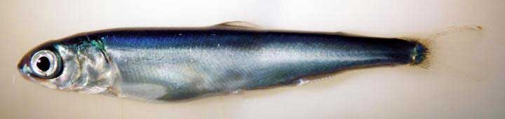
This is a juvenile pink salmon exposed to low levels of crude oil as an embryo. While these fish appear outwardly normal, they nevertheless developed heart defects that compromised their ability to swim. Fish that are less able to forage and avoid predators are much less likely to survive to adulthood. (NOAA)
Previous research has shown that crude oil disrupts the contraction of the fish heart muscle cells. Embryonic fish exposed to trace levels of crude oil grow into juveniles with abnormal hearts and reduced cardiorespiratory function.
“With this very early impact on the heart, you end up with an animal that just can’t pump blood through its body as well, which means it can’t swim as well to capture food, form schools, or migrate,” said Mark Carls, toxicologist at the Alaska Fisheries Science Center. “Crude oil is changing basic physiology, or what makes a fish a fish.”
The research builds on earlier work by the Auke Bay Laboratories, part of NOAA Fisheries’ Alaska Fisheries Science Center, which found much reduced survival of pink salmon exposed as embryos to polycyclic aromatic hydrocarbons (PAH) from crude oil.
“Our findings are changing the picture in terms of assessing the risk and the potential impacts of oil spills,” said Nat Scholz, leader of the NWFSC’s ecotoxicology program and a coauthor of the new study. “We now know the developing fish heart is exquisitely sensitive to crude oil toxicity, and that subtle changes in heart formation can have delayed but important consequences for first-year survival, which in turn determines the long-term abundance of wild fish populations.”
The Exxon Valdez aground on Bligh Reef in Prince William Sound in March 1989. (NOAA)
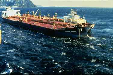
The Exxon Valdez spill was the largest in U.S. history, with extensive oiling of shoreline spawning habitats for Pacific herring and pink salmon, the two most important commercial fish species in Prince William Sound.
Herring larvae sampled in proximity to oil were visibly abnormal, and mortality rates were higher for pink salmon embryos at oil spill sites than unaffected regions.
The herring fishery collapsed three to four years after the spill, when the herring spawned in oiled areas reached reproductive maturity.
The paper notes that the contribution of the spill to the herring population collapse, if any, was never determined and remains controversial.
Other studies, however, tend to confirm the findings, including heart problems for fish exposed to the Gulf of Mexico Deepwater Horizon spill and even fish exposed to naturally occurring oil seeps.
The new findings suggest that the delayed effects of the spill may have been important contributors to the declines.
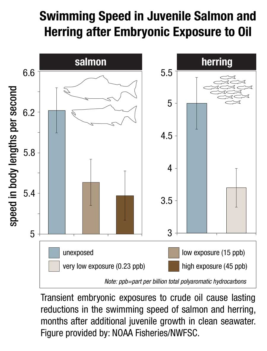
This image shows transient embryonic exposures to crude oil cause lasting reductions in the swimming speed of salmon and herring, months after additional juvenile growth in clean seawater. (NOAA)
Scientists from the Northwest Fisheries Science Center and Alaska Fisheries Science Center temporarily exposed embryonic salmon and herring to low levels of crude oil from the North Slope of Alaska and found that both absorbed chemicals at similar concentrations in their tissues. The embryos were then transferred to clean seawater and raised as juvenile fish for seven to eight months.
Few of the exposed embryos were outwardly abnormal in any way. However, closer examination of the fish revealed subtle defects that could reduce their long-term survival.
Juvenile salmon exposed to oil grew more slowly, with those exposed to the highest concentrations growing the slowest. For salmon, early survival in the ocean is strongly influenced by juvenile growth, with smaller fish suffering higher loss to predators.
Scientists used swimming speed as a measure of cardiorespiratory performance and found that fish exposed to the highest concentrations of oil swam the slowest. Slower swimming is an indication of reduced aerobic capacity and cardiac output, and likely makes fish easier targets for predators.
Exposure to oil as embryos altered the structural development of the hearts of juvenile fish, potentially reducing their fitness and swimming ability. Poor swimming and cardiac fitness is also a factor in disease resistance.
Earlier studies on the ecosystem-scale crash of the Prince William Sound herring population several years after the Exxon Valdez spill were based on higher levels of exposure to the oil. The new study shows that that cardiac injury occurs in normal-appearing fish that survive even lower level exposures.
The scientists reviewed data on measured oil concentrations in surface water samples collected in Prince William Sound after the oil spill and during the 1989 herring spawning season. Most of the 233 samples contained less oil than was believed to be toxic to herring at the time, based on visible gross developmental abnormalities. However, nearly all of the samples contained oil at or above concentrations shown in the new study to alter heart development.
If the Exxon Valdez spill impacted heart development among a large majority of fish that were spawned in proximity to oiled shorelines, the subsequent losses of juveniles to delayed mortality would have left fewer adults to join the population. Although not direct proof, this provides a plausible explanation for the collapse of the Prince William Sound herring stock four years later, when fish spawned during the oil spill would have matured.
The study concludes that the impacts of the Exxon Valdez spill on near shore spawning populations of fish are likely to have been considerably underestimated in terms of both the geographic extent of affected habitat and the lingering toxicity of low levels of oil. The findings will likely contribute to more accurate assessments of the impacts of future oil spills, Incardona said. “Now we have a much better idea of what we should be looking for,” he said.
That means, according to the study “that the impacts of the Exxon Valdez oil spill on populations of near shore spawning fish are likely to have been considerably underestimated, in term of both the geographic extent of affected habitats and the lingering toxicity of low levels of residual oil.”
The report calls for more studies of the sensitivity of the developing fish heart since the vulnerability “also has implications for other pollution sources in marine ecosystems, including increasing maritime vessel traffic and expanding land-based urban runoff.”
Scientific studies after the Exxon Valdez spill indicated that the vast majority of species recovered following the spill and that functioning ecosystems, similar to those existing pre-spill, were established.
Species for which recovery is not fully apparent, such as Pacific herring, killer whales, and pigeon guillemots, appear to have been affected by other environmental factors or human influences not associated with the oil spill. Insufficient pre-spill baseline data on these species contributed to difficulties in determining the extent of spill effects.
Based on the evidence, the Panel finds that natural recovery of the aquatic environment after an oil spill is likely to be the primary recovery mechanism, particularly for marine spills. Both freshwater and marine ecosystem recovery is further mitigated where cleanup is possible, effective, and beneficial to the environment.
Natural processes that degrade oil would begin immediately following a spill. Although residual oil could remain buried in sediments for years, the Panel finds that toxicity associated with that oil would decline over time and would not cause widespread, long-term impacts.
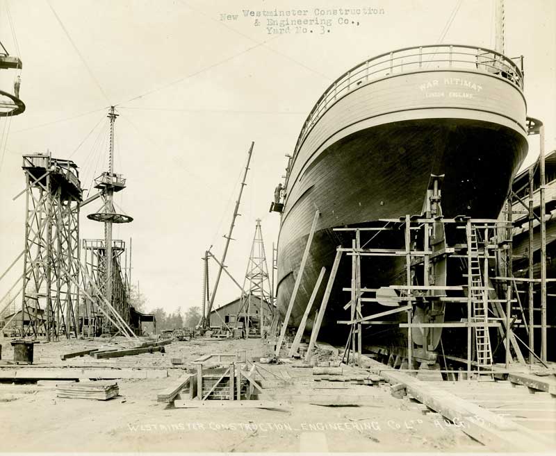
Ninety-seven years ago, long before the main townsite was founded in the 1950s, (the Haisla Nation, of course, had been here for thousands of years) Kitimat was to play a short, now forgotten and unlucky role in the First World War with the launch of a vessel in New Westminster called the War Kitimat as one of the many emergency new ships commissioned by the British government to replace vessels lost to Germany’s unrestricted submarine warfare that was sinking convoys taking vital supplies across the Atlantic.
During the First World War, over nine million gross tons of British ships were lost due to enemy action, both submarines and surface raiders. The worst losses came in the three months ending June 1917 when over 1.4 million gross tons were sunk.
In December, 1916, the Prime Minister David Lloyd George’s British Government appointed a “shipping controller” to manage a worldwide shipbuilding program to replace the lost vessels, to be built quickly, efficiently and to a series of standard designs. Although the vessels were often different, they were called “standard ships.” It was the Great War’s equivalent of the Liberty Ships built during the Second World War.
Many of the orders were placed with Canadian companies, others with the Japanese shipyards and British owned or controlled shipyards in Hong Kong and Shanghai. Canada created or contracted 19 emergency shipbuilders which built 137 cargo ships and 15 trawler/minesweepers. Some of these yards were purpose-built, others were repair yards that were converted to construction yards; seven were in BC, nine were in Ontario and Quebec, and three were in the Maritimes.
Orders were also placed with shipyards in the United States, but when the Americans entered the war in 1917, those ships were requisitioned by the U.S. Government.
All the ships’ names were given the prefix “War” no matter where they were built in the world.
The Canadians built both steel hulled and wooden hulled cargo vessels, including the War Kitimat, as well as yachts and sailing yachts (which likely became the war time “trawlers”). The British built 12 different types of “dry cargo” vessels, five types of “coasters” plus tankers. The United States also built wooden hulled cargo vessels (slightly larger than the Canadian versions) and various types of steel hull cargo ships.
The government of France also contracted Canadian shipyards for its own vessel building program.
In Canada, the BC Marine Railway Company was one of the prime contractors, and the job of building four ships was awarded to the New Westminster Shipbuilding & Engineering on Poplar Island, which can be seen today from New West’s Esplanade at Westminster Quay.
The First Nations of the area had used the island for generations and in 1871 the island was designated an Indian Reserve. During the small pox epidemic of 1889, with many members of the Vancouver area First Nations struck down by the disease, a hospital was built on the island. It is believed that many of those who died of smallpox were buried there. Because of the association with disease and death the island was abandoned until 1917, when the war time necessity meant a shipyard was built on the island.
New Westminster Shipbuilding had the job of constructing four “war” class wooden hulled freighters, 2300 gross tonnes, 3300 dead weight tonnes, 250 feet long with a beam of 43.5 feet, with 322 nominal horse power triple reciprocating steam engines powered by two water tube boilers, turning a single screw capable of ten knots.
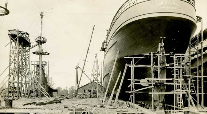
The company built four ships, the War Comox, War Edensaw, War Kitimat and War Ewen. The War Comox was first launched in April, 1918, but completion was held up as the shipyard waited for equipment from suppliers. That led to pressure to build, launch and complete the War Edensaw, which was launched in June 1918, and the War Kitimat, which was launched on Sunday, August 18, 1918.
The War Kitimat immediately ran into trouble. According to the Times Colonist, right after launch the War Kitimat ran aground off New Westminster and had to be lifted off the Fraser river bed by using jacks until was raised enough so that tugs could attach lines and tow it to deep water. About a week later, the War Kitimat was towed to Victoria for repairs and further fitting out (possibly to the Foundation Company shipyard which was also building five of the war class vessels. Foundation is now Seaspan’s Point Hope Marine)
The War Kitimat did make at least one voyage to Great Britain, but by the time it arrived, the war was coming to a close. After the Armistice on November 11, 1918, the ships were no longer needed and the British government sold most of them to shipping companies. (All the ships were UK registry, not Canadian)
Flag for Lloyd RoyalBelge line
In 1919, the War Kitimat was sold to the Lloyd Royal Belge S.A. line of Antwerp, Belgium and renamed the Serbier.
On January 12, 1920, the Serbier, on a voyage from Cartagena and Oran to Antwerp with zinc ore and general cargo on board, sprang a leak in her engine room during a “raging gale” in the Bay of Biscay and sank 80 nautical miles (150 km) off Penmarc’h, Finistère, France at 47°38′N 6°10′W. Her Capt. A. Canfrère and the crew were rescued by the French ship SS Docteur Pierre Benoit.
How the ship came to be named War Kitimat isn’t certain. It was probably named after the Kitimat River since other vessels in the War category were named Skeena, Stikine, Babine, Niagara, Ottawa (others were named for cities like Halifax or Toronto).
The Belgian shipping company did not give up on the name Serbier. It purchased another US-built War cargo ship, first named the War Hound by the British. After the US entered WWI in 1917 and took over the building there it became the Lake Huron, a US Navy Transportation Service mine carrier. From later in 1920, Royal Belge operated the new Serbier until 1924, when it passed through French, Norwegian, Danish and then as the Advance, Finnish ownership. The Advance was seized in Panama by the United States in 1941 and renamed the Trojan. After the Second World War, the US returned the ship to Finland. It sailed as the Advance until it was sold a Greek shipping company in 1965 and scrapped at Piraeus in 1966.
Of the ships under British control, 821 ships were ordered by the UK shipping board and 416 were completed. Fourteen were lost to enemy action. The remaining orders were cancelled but often completed by the shipyards.
Many of the “war” or “standard” ships passed through various owners.
During the Second World War many played their original role and took part in the convoys that crossed the Atlantic. Many were sunk during those crossings. Others, sold to growing Japanese shipping interests in the 1920s and 1930s, were sunk by US destroyers and submarines. Others like the War Hound /Serbier survived to the 1950s and 1960s.
Of the War Kitimat’s sister ships built in New Westminster, the War Comox was sold to an Italian company, renamed the Guidatta and scrapped at Genoa in 1925, The War Ewen was sold to a German company, renamed the Etienne Marcel and scrapped in Germany in 1925. The War Edensaw, under the original name, was carrying Admiralty stores from Constantinople to Malta, when it caught fire on June 25, 1919 and sank 94 nautical miles east of the St. Elmo Lighthouse on Malta.
As for Poplar Island, it was zoned for industrial use but no one could come up with ideas for how to use the island. New Westminster sold the island to Rayonier Canada in 1945, where it became an anchorage for log booms on the Fraser River. The successor company, Western Forest Products sold it back to New Westminster in 1995, The island is still a wilderness area in the middle of urban Vancouver and subject to treaty and land claims negotiations with the area’s First Nations.
The Ship’s List (database of ships, link is to Lloyd Royal Belege entry)
Editor’s Note: Up until now Kitimat has not had a reason, unlike other communities, to mark Canada’s role in the First World War. We suggest that should the District of Kitimat choose to do so either this year or in the next three years, August 18, the date of the launch of the War Kitimat might be an appropriate date, in addition to Remembrance Day on November 11.
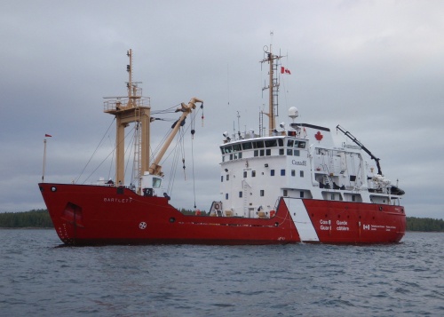
The United States Coast Guard says the US and Canadian Coast Guards will “conduct a towing evolution using a State of Alaska Emergency Towing System” on Friday afternoon off Juneau, Alaska.
The participating vessels are the Canadian Coast Guard Marine Service Vessel and Ice Strengthened Medium Navaids Tender CCGS Bartlett and the US Coast Guard cutter USGC Maple. Like the Barlett, the Maple is also a buoy tender.
CCGS Barlett (Canadian Coast Guard)
In 2014, when the Russian vessel Simushir was adrift off Haida Gwaii, the towing system on the Canadian Coast Guard’s Gordon Reid was inadequate and the line snapped. A commercial tug was hired to take the Simushir into port at Prince Rupert. As Northwest Coast Energy News reported in October, 2014, the US Coast Guard deployed the Alaska Towing System to Haida Gwaii but it wasn’t used at that time despite a record of success by the US Coast Guard in towing vessels off Alaska waters.
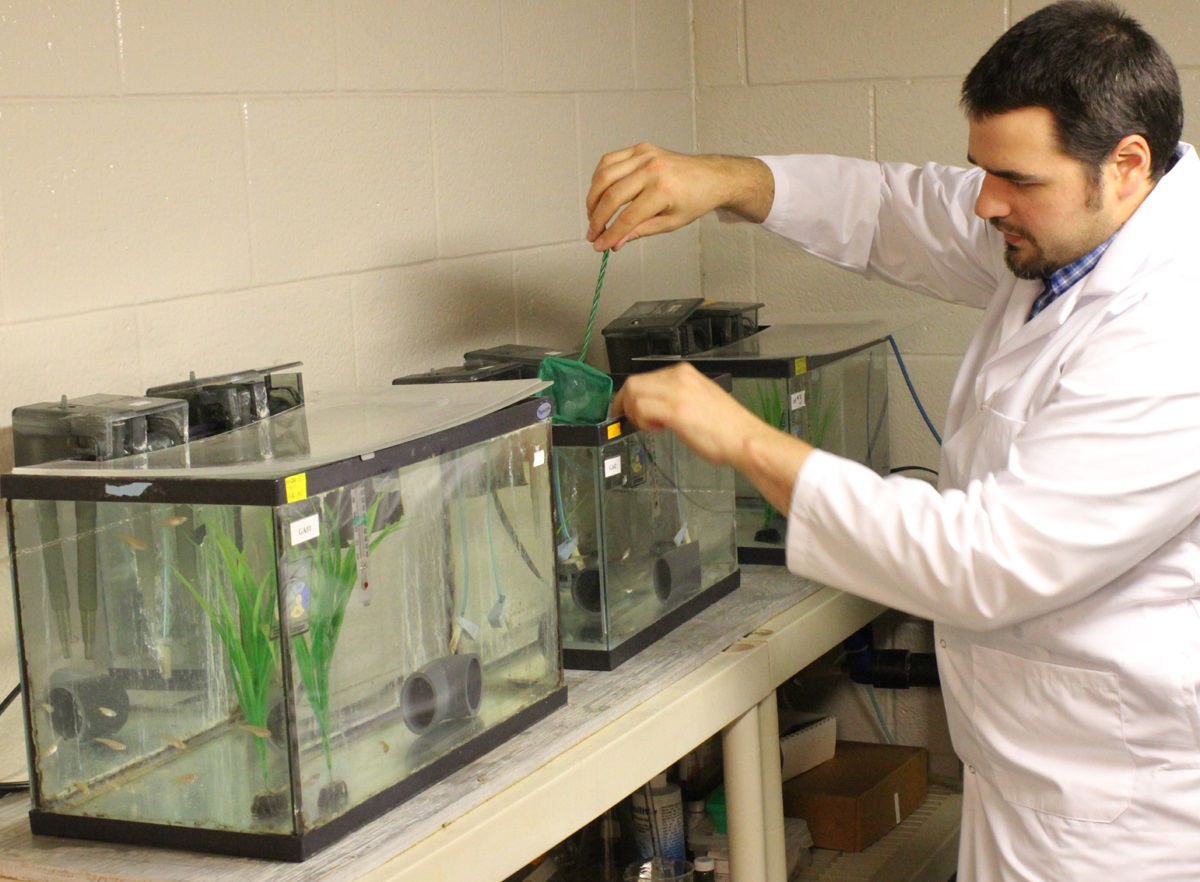
Diluted bitumen, also known as dilbit, a mixture of oil sands bitumen and natural gas dilutants can seriously harm fish populations, according to research study at Queen’s University and the Royal Military College of Canada published this week.
At toxic concentrations, effects of dilbit on exposed fish included deformities and clear signs of genetic and physiological stress at hatch, plus abnormal or uninflated swim bladders, an internal gas-filled organ that allows fish to control their buoyancy. Exposure to dilbit reduces their rate of survival by impairing their ability to feed and to avoid predators.
Post-doctoral fellow Barry Madison works with the fish in Valerie Langlois’ lab. (Queen’s University)
Among the other findings from the study were
Embryo toxicity of dilbit was comparable to that of conventional oils.
Developmental malformations increased with increasing dilbit concentrations.
Chemical dispersion broadened the genotoxic effects of dilbit
“This new study provides a clearer perspective on the potential risks to Canada’s aquatic resources of dilbit spills, and a technical basis for decisions on dilbit transportation within Canada,” says Peter Hodson Environment Studies, Biology at Queens. “It reduces some of the uncertainty and unknowns about the hazards of dilbit.”
This study characterized the toxicity and physiological effects of unweathered diluted bitumen (Access Western Blend dilbit; AWB) to a fish used for laboratory studies. Embryos of Japanese medaka (Oryzias latipes) were exposed for 17 days to dilutions of dilbit physically-dispersed by water and chemically-dispersed by dispersants
AWB dilbit exposure was not lethal to medaka, but resulted in a high prevalence of blue sac disease (BSD), impaired development, and abnormal or un-inflated swim bladders. Blue sac is a disease of young trout and other salmonid species; usually caused by unsuitable hatchery water. It turns the yolk sac bluish and is thought to be caused by a lack of oxygen.
The research was funded by Fisheries and Oceans Canada’s National Contaminants Advisory Group and the next stage will determine whether fish species native to Canada will be affected by dilbit exposure. The work also includes the development of genetic markers of exposure to dilbit and toxicity that could be used to assess whether wild fish that survive a spill are still affected.
The research team includes Dr. Valérie Langlois (Environmental Studies, Royal Military College of Canada) and Dr. Barry Madison (Royal Military College of Canada).
Dr. Hodson is also a member of a Queen’s research team tasked to determine whether dilbit spilled into rivers would contaminate bed sediments, specifically areas where fish such as salmon, trout, chars, whitefish and graylings spawn, to the extent that the survival of their embryos would be affected.
The research was published in ScienceDirect and is one of the first studies of dilbit on young fish.
The finding could be significant because both the proposed Northern Gateway pipeline and the proposed Kinder Morgan expansion will cross areas near spawning streams.
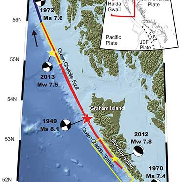
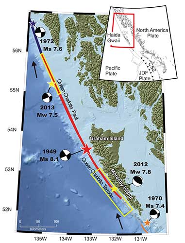
A “devastating megathrust earthquake” could hit Haida Gwaii sometime in the future, according to Canadian and US studies carried out after the magnitude 7.8 earthquake off Haida Gwaii on Oct. 27, 2012 and the 7.5 magnitude quake off Craig, Alaska, a few weeks later on Jan. 5, 2013.
The 2004 Indian Ocean earthquake and the 2011 Tōhoku earthquake in Japan, both accompanied by major tsunamis are recent examples of “great” (higher than magnitude 8.0) megathrust earthquakes. Most of the concern on the west coast has been the likelihood of a megathrust earthquake on the Cascadia Fault on the Juan de Fuca plate that stretches from northern California to the middle of Vancouver Island.
The 2012 Haida Gwaii main shock was the second largest seismic event in Canada since the establishment of a modern seismograph network. The first was the 1949 Haida Gwaii/Queen Charlotte earthquake with a magnitude of 8.1 That 1949 Haida Gwaii earthquake was a strike-slip event, where the plates move side-to-side, similar to the 1906 San Francisco earthquake and other quakes on the San Andreas Fault in California.
The 2012 Haida Gwaii earthquake is characterized in the studies as a “mini-megathrust” event, where part of the crust is pushed upward, meaning that a larger megathrust could have much more destructive consequences from both the earthquake and a possible tsunami.
A diagram of the situation off Haida Gwaii that triggered the October 2012 “mini megathrust” earthquake seen at the lower centre, while the 1949 slip strike earthquake is seen at the top. (Bulletin of the Seismological Society of America)
Complex system of faults
The new studies show that the Pacific and North America plate boundary off the coast of British Columbia and southeastern Alaska creates a system of faults capable of producing very large earthquakes. The scientists conclude that while the two earthquakes in 2012 and 2013 released strain built up over years on the tectonic plates, those events did not release strain along the Queen Charlotte Fault off the west coast of Haida Gwaii. That means the fault remains the likely source of a future large earthquake.
Map showing the pattern of earthquakes along the Queen Charlotte Fairweather Fault system and the location of the Queen Charlotte Terrace. (Bulletin of the Seismological Society of America)
A special issue of the Bulletin of the Seismological Society of America (BSSA), released Monday, April 6, 2015, contains 19 scientific and technical papers, outlining the results of the work carried out over the past two years.
The team estimated the rupture dimension of the 2012 Haida Gwaii earthquake to be about 120 kilometres long at a depth of about 30 kilometres.
The Craig earthquake ruptured the Queen Charlotte fault over a distance of more than 100 kilometres and at a depth of about 20 kilometres.
The two areas are joined in what is called the Queen Charlotte Fairweather Fault System. To the south the Queen Charlotte Fault also interacts with the Juan de Fuca plate that stretches from Vancouver Island to northern California.
“The study of these two quakes revealed rich details about the interaction between the Pacific and North America Plates, advancing our understanding of the seismic hazard for the region,” said Thomas James, research scientist at Geological Survey of Canada.
Two faults off Haida Gwaii
The studies conclude that the interaction between the plates off Haida Gwaii is much more complex than previously believed. Before the 2012 earthquake, the Queen Charlotte Fault, a strike-slip fault similar to the San Andreas Fault in California, was believed to be the dominating tectonic structure in the area. The 2012 tremor confirmed the existence of a previously suspected thrust fault beneath what is called the “Queen Charlotte Terrace,” to the west of the Queen Charlotte Fault, where the Pacific plate is sliding at a low angle below the North American plate.
The Queen Charlotte Terrace, which is about a kilometre below the surface of the ocean, is built up of layers of sediment, several kilometres thick, scraped off the oceanic plate as it subducts under the North American plate. It may also include some fragments of oceanic crust. For most of the terrace, it is “present as a clearly defined linear feature,” but the study adds: “north of about 53.5° N, a complex pattern of ridges and valleys appears.”
The earthquake was “essentially a mini-megathrust earthquake along the dipping plate interface of a subduction system,” one of the scientific papers says. The epicenter of the Haida Gwaii main shock was located about five kilometres landward (northeast) of the Queen Charlotte Fault. That probably means that the rupture was near the bottom of the locked plates, where the plate motion’s side to side movement is also thrusting downward. Significant aftershocks appeared to cluster on the periphery of the main rupture zone with most of the aftershocks occurring seaward to the west.
The scientists used GPS observations of crustal motion to locate the earthquake’s rupture offshore to the west of Haida Gwaii.
The situation off Haida Gwaii is complex because while the Pacific plate is converging with the North American plate at a rate of 15 to 20 millimetres a year, at the same time the two plates are slipping by each other toward the north northwest at angle of about 20 degrees at a rate of about 50 millimetres a year.
Honn Kao, a seismologist with the Geological Survey of Canada said, “This was an event the thrust interface of the plate boundary system, confirming that there is a subduction system in the Haida Gwaii area.
“The implication of a confirmed subduction zone is that in addition to the Queen Charlotte Fault, we now have another source which can produce devastating megathrust earthquakes in the area,” said Kao.
The study of the Haida Gwaii tremor looked at the causative faults, the rupture processes and depths of the main shock and sequence of strong aftershocks.
The Haida Gwaii earthquake generated a significant tsunami that left deposits indicating run-up exceeding 3 metres (maximum 13 metres) in a number of bays and inlets along about 230 kilometres along the west coast of Haida Gwaii. In Hawaii, a 0.8 metre wave was measured on a tide gauge.
In Queen Charlotte City perceptible shaking lasted for one and half to two minutes, with very strong shaking for about 30 seconds. The earthquake was felt as far away as Yukon Territory, Alberta, and Montana.
The study says “Damage was limited, in part owing to the sparse population, but also because of the seismic resistance of the generally low rise, wood-frame buildings on the islands. Felt intensities were at expected values close to the source zone, but regional intensities were smaller than predicted.”
The Haida Gwaii rupture also shook southeastern Alaska. The northwest direction of ground motion then may have influenced the timing of the Craig earthquake a few weeks later in January 2013. That earthquake occurred farther north in southeast Alaska, where relative plate motion is nearly parallel to the Queen Charlotte fault.
Aftershocks
.
Map showing the pattern of aftershocks following the October 2012 Haida Gwaii earthquake. (Bulletin of the Seismological Society of America)
The Haida Gwaii aftershocks clustered around the periphery of the rupture zone, both on the seaward and landward side of the plate boundary and reflected what the study calls “normal faulting behavior–caused by the bending, extending or stretching of rock– rather than the thrust faulting of the main shock.” The pattern of aftershocks is similar to those observed after the 2011 Japanese megathrust earthquake.
“Our observations of normal faulting imply that the main shock of the Haida Gwaii earthquake dramatically altered the stress field in the rupture zone, especially in a neighboring region,” Kao said.
The distribution of aftershocks occurred to the north of a previously identified seismic gap where large earthquakes have not occurred in historic times. The gap is located to the south of the where 1949 magnitude 8.1 Queen Charlotte earthquake ruptured.
Though the Haida Gwaii earthquake may have activated some part of the Queen Charlotte Fault, Kao said, it was limited and did not relieve stress along the seismic gap.
The study concludes:
The Haida Gwaii event confirmed substantial seismic and tsunami hazard from large thrust events on the plate margin along the southern Queen Charlotte fault. It occurred where relatively young oceanic lithosphere under thrusts North America and in some ways is an analog for the much larger megathrust earthquakes known to occur on the Cascadia subduction zone to the south, where the young Juan de Fuca plate and other small plates subduct beneath North America. The Haida Gwaii earthquake had a complex pattern of main shock rupture and aftershocks and a large tsunami.
Further study needed
The Geological Survey of Canada plans further studies to understand the formations off Haida Gwaii.
One question to ask is if there are any records of major earthquake events in the past history of Haida Gwaii. The study notes that the impact of the tsunami was relatively minor “in this region with steep rocky coastlines.” That means there are limited sources of coastal sediments that can be checked for past events. It adds: “Low-elevation lakes, ponds, and bogs may offer the best opportunities for paleotsunami studies” warning that large earthquakes in the past that produced tsunamis may have left little evidence in the “paleoseismic record of Haida Gwaii and similar settings worldwide.”
Megathrust earthquakes occur at subduction zones at destructive plate boundaries where one tectonic plate is subducted (forced underneath) by another. These interplate earthquakes are the planet’s most powerful, with moment magnitudes that can exceed 9.0. Since 1900, all earthquakes of magnitude 9.0 or greater have been megathrust earthquakes. During the rupture, one side of the fault is pushed upwards relative to the other, and it is this type of movement that is known as thrust. The displacement of the ocean in a thrust can trigger a tsunami.
Transform fault
A transform fault is one where the motion is predominantly horizontal. Those faults end abruptly and are connected on both ends to other faults, ridges, or subduction zones. The best-known (and most destructive) are those on land at the margins of tectonic plates. Transform faults are the only type of strike-slip faults at plate boundaries show strike-slip or side-to-side in movement.
Queen Charlotte Terrace
The Queen Charlotte Terrace is a 25 kilometre wide zone of built up marine sediment immediately west of the active Queen Charlotte fault. The crust is about 12 kilometres thick at the terrace. On Haida Gwaii, the earth’s crust is 18 kilometres thick at the eastern edge. On the BC mainland the crust is in excess of 30 kilometres thick.
Historic earthquakes.
The 1949 Haida Gwaii quake was one of the largest in the recorded history of North America.
The largest known earthquake along the coast was the megathrust event on the Cascadia fault on January 26, 1700 where the Juan de Fuca plate ruptured for about 1,000 kilometres along from what is now northern California to Vancouver Island, estimated at magnitude 9.0. The dating is based on a tsunami that hit Japan that had no associated local earthquake as well studies of tree rings from the remains of trees downed in the tsunami.
Three studies of the geology of Douglas Channel are near completion and publication, according to Natural Resources Canada. That news comes as studies, released today, warn of a major megathrust earthquake on the fault west of Haida Gwaii.
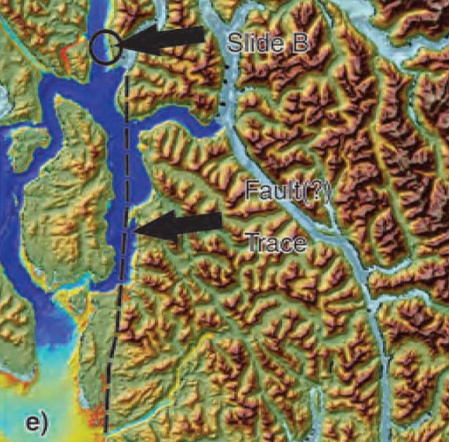
Northwest Coast Energy News asked the Geological Survey of Canada if there were any recent updates available after the agency said that a survey had located a “possible fault” on Hawkesbury Island during studies for the Enbridge Northern Gateway Joint Review Panel.
Natural Resources Canada responded with a statement: “NRCan continues to conduct research studies in the area, including study of possible faults. Three scientific expeditions have been completed on board Coast Guard research ships. The first two reports are in the final stages of editing, and will be published in the coming months. The third expedition was just completed; therefore the third report will be available later.”
More recently there were slope failures nearer to Kitimat. The first slope failure occurred on October 17, 1974, triggering a 2.4 metre tsunami at low tide. Then on April 27, 1975 there was a second slope failure near low tide on the northeast slope of the Kitimat Arm that generated an 8.2 metre tsunami. The 1975 tsunami destroyed the Northland Navigation dock near Kitimat and damaged the Haisla First Nation docks at Kitamaat Village.
Thomas James, of the Geological Survey told Northwest Coast Energy news about the team’s finding on the Haida Gwaii earthquake: “The studies focused on the Haida Gwaii and Craig earthquakes which happened at the Pacific and North American plate boundary, west of Haida Gwaii, so east of Haida Gwaii there’s no comparable plate boundaries that gives rise of historic sieismisticity.”
As well as the fact that recent studies say the mainland margin coastal zone has had very little historical seismicity, it adds no currently active faults have been identified. A study ten years ago identified some very ancient faults which have not been active since the Eocene, about 33 to 56 million years ago.
GPS studies show that in northwestern British Columbia coastal block is moving northeast at the rate of just 5 millimetres a year.
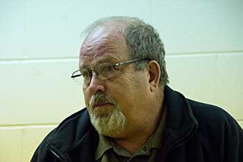
Kitimat Emergency Coordinator Bob McLeod at the earthquake postmortem Oct. 29, 2012 (Robin Rowland/Northwest Coast Energy News)
Studies of the October 2012 magnitude 7.8 Haida Gwaii earthquake show that the region is vulnerable to a “major megathrust” earthquake along a newly confirmed fault line west of the islands.
That earthquake was felt in Kitimat and Kitamaat Village and a tsunami warning was issued within a few minutes.
So have the District of Kitimat, the Haisla Nation Council or Rio Tinto Alcan changed or upgrading their earthquake and tsunami plans in the past couple of years?
Bob McLeod, who recently retired as the District of Kitimat’s emergency coordinator, told Northwest Coast Energy News: “I think we’ve done quite a bit. One of the biggest issues in the first one was trying to get information out. We’ve come a long way on that. Whether you reach everyone or not, that’s another thing, because you never reach everybody. One of the critical things to me is getting the information out so you avoid all this Facebook, Twitter speculating and rumour. The communications aspect has improved a hundred fold.
“We did more work on the mapping and planning. Over the course of the last year, there were a lot of meetings with industry and various stakeholders, discussing emergency preparedness in general but touching on some of these other things as well.
“One of the things we did was to try to set up some shelter points. We have an agreement with the Baptist Church, the Catholic Church and the Seventh Day Adventists. They’re strategically located and could be gathering points for the various neighborhoods if necessary.
“We’ve also done quite a lot of work on Riverlodge as a group lodging centre, thinking in terms of an earthquake where there may be damage and you have to move people.
“We did look at the evacuation planning and we’ve had a couple of exercises involving that, looking strategically about how can you move people from certain neighborhoods, asking which neighborhoods would be at the most risk if you ended up with a tsunami situation.
As for tsunamis, McLeod said, “From everything we’ve heard and been told, tsunamis in extremely deep water like that is not going to be as dangerous as one in shallower water, but the possibility is still there.
“The thrusts are the killers when it comes to tsunamis, but there is a very good warning system on the tsunamis. We do get very very rapid feedback on the earthquakes.
“The only danger in that regard is if you have a severe earthquake and you have part of a mountain drop into the salt chuck, you’re going to get a massive wave and you’re going to get no warning whatsoever, like the Moon Bay collapse in the seventies.
“The emergency plan is in good shape. We scheduled a number of exercises last year through training programs.
“One of the things I personally push is personal preparedness. I think as a community, we fail greatly at that. That was evident even during the snowstorm. People are not just prepared to look after themselves, it’s unfortunate. You just have to keep chipping away.”
Last week, Northwest Coast Energy News asked Rio Tinto Alcan and the Haisla Nation Council if either could comment on updated earthquake or tsunami response plans. So we have received no answers.
 The District of Kitimat Friday afternoon lifted the boil water advisory declared during a heavy rain storm late last Saturday. The District says system flushing may result in some discoloured water, but it is safe to drink and the water should run clear quickly.