CHICAGO (March 14, 2013) – The U.S. Environmental Protection Agency today issued an administrative order that requires Enbridge to do additional dredging in Michigan’s Kalamazoo River to clean up oil from the company’s July 2010 pipeline spill. EPA’s order requires dredging in sections of the river above Ceresco Dam, upstream of Battle Creek, and in the Morrow Lake Delta.
EPA has repeatedly documented the presence of recoverable submerged oil in the sections of the river identified in the order and has determined that submerged oil in these areas can be recovered by dredging. The dredging activity required by EPA’s order will prevent submerged oil from migrating to downstream areas where it will be more difficult or impossible to recover.
Enbridge has five days to respond to the order and 15 days to provide EPA with a work plan. Dredging is anticipated to begin this spring and is not expected to result in closures of the river. EPA’s order also requires Enbridge to maintain sediment traps throughout the river to capture oil outside the dredge areas.
On July 26, 2010, Enbridge reported that a 30-inch oil pipeline ruptured near Marshall, Michigan. Heavy rains caused the spilled oil to travel 35 miles downstream before it was contained.
Here are edited portions of the EIS assessment for a major oil terminal at Prince Rupert
Environmental Setting
The EIS says “the local surface geology at the Prince Rupert site consists of bedrock (granitic rocks) overlain by glacial outwash and a thin soil cover.” and goes on to note that “Prince Rupert is located along the coastal region of Canada, which is seismically active.”
Potential Impacts
At Prince Rupert, depth to bedrock is expected to be relatively shallow, so rock ripping and some blasting could be necessary. The impacts of rock ripping and blasting are limited to the immediate area and would not result in any significant impacts to the underlying or nearby geology. Excavation activities, erosion of fossil beds exposed due to grading, and unauthorized collection can damage or destroy paleontological resources during construction.
(The report notes that The potential for finding paleontological resources in the areas that would be disturbed is unknown. But the area of the coast has been heavily metamorphisized and most fossils, so far, have been found further inland, largely along the Copper River near Terrace)
In terms of geologic hazards, the Prince Rupert terminals would be located along the coastal region of Canada, which is seismically active. In addition, the presence of steep slopes increases the risk of landslides and the port’s coastal location increases the risk of flooding…. The Prince Rupert rail terminals and port facilities would be designed to withstand potential seismic hazards and flooding…
Construction of the proposed terminals and port expansion in Prince Rupert would result in the disturbance of approximately 3,500 acres (1,400 hectares) of land for the construction of the rail terminal complex and approximately 1,200 acres (487 hectares) for the expansion of the port. Potential impacts to the soils resources of the area could result from vegetation clearance, landscape grading, and recontouring to ensure proper drainage, the installation of storm water drainage systems, construction of the required infrastructure, and other construction activities.
One of the primary concerns during construction activities is soil erosion and sedimentation.
Potential impacts to soils from erosion are expected to occur in areas where the slopes are greater than 20 per cent and where the erosion potential due to their nature is high. Based on available landscape and soils information, the soils found in the area are not highly erodible and the required infrastructure would be located in areas that are relatively flat. Therefore, the impact of the proposed terminal complex and port construction activities on soil erosion would be minor.
Groundwater Environmental Setting
The Prince Rupert Terminals and port expansion would occur in British Columbia on Kaien Island, which receives about 102 inches of rainfall per year. The terminals would be located on an inlet that is part of the eastern Pacific Ocean on the Venn Passage near the much larger Inland Passage, which extends from Washington State to Alaska along the islands and mainland of British Columbia, Canada. Venn and Inland Passages are marine (salt water) waterbodies. The islands consist of bedrock (granitic rocks) overlain by glacial outwash and a thin soil cover.
Groundwater is shallow, poor quality, and unused. Drinking water is derived from lakes on the mainland. Water quality in the terminal complex area is seawater and inland brackish.
Potential Impacts
During construction of the facilities at Prince Rupert, the primary potential impacts to groundwater would be spills or leaks from construction equipment. Mitigation for these impacts includes having in place appropriate plans in place and appropriate cleanup materials available.
During operations of the facilities at Prince Rupert, the primary potential impacts to groundwater would again most likely be spills or leaks from operation equipment or associated with crude oil unloading of railcars. Although the initial impacts of potential releases or spills may be contained or limited to soil, potential impacts to groundwater may occur depending on the depth to groundwater, soil characteristics (e.g., porosity, permeability), spill volume and extent, and whether the spill reaches surface water bodies, some of which are interconnected to groundwater.
Surface Water Environmental Setting
The upland character surrounding the potential Prince Rupert terminal area is dominated by bog forest uplands and the flowing surface water bodies are predominantly precipitation- and shallow groundwater-fed intermittent streams. Some open waterbodies are present in the southeast portion of Kaien Island. Tidal shore zones are of a rugged and rocky nature and receive wave energy generated by naturally occurring fetch and large wakes from marine traffic. Winter winds are strong and from the southeast to southwest, with surface currents predominantly northward from the Hecate Strait. Lighter summer winds have less influence on currents and allow freshwater runoff from land and deep water tidal effects to exert more control and provide variation in summer current patterns. Significant wind and tidal mixing tend to occur where waters are shallow and around islands and rocky points of land. The coastal landscape is predominantly fjords carved into the granitic Coast Mountains, created by the last of several glacial periods approximately 12,000 years ago. Shores tend to be rocky and steep with beaches restricted to sheltered areas adjacent to estuaries and the navigable straits and channels provide a wide variety of exposures and habitats.
Potential Impacts
Construction of the facilities at Prince Rupert would disturb approximately 4,700 acres. The primary potential impacts to surface waters include erosion and sedimentation and spills/leaks of hazardous materials. Mitigation for these impacts includes having in place appropriate SPCC plans in place and appropriate cleanup materials available.
During operations, the primary potential impacts to surface waters include storm water runoff, spills, or leaks from operation equipment or associated with crude oil unloading of railcars.
Provision of storm water management measures would mitigate the impacts of stormwater runoff.
Terrestrial Vegetation Environmental Setting
The Prince Rupert terminals and port facilities would be located in the Coastal Gap Level III Ecoregion. The vegetation immediately adjacent to the Pacific Ocean includes stunted, opengrowing western red cedar, yellow cedar, and western hemlock with some stunted shore pine and Sitka spruce . There are also open areas present within the affected areas. It is unclear if biologically unique landscapes or vegetation communities of concern exist within the proposed Prince Rupert terminal complex boundary.
Potential Impacts
The proposed rail terminal complex and port facilities at Prince Rupert would require the clearing of up to 4,700 acres of natural vegetation, most of which is forested based on aerial photo interpretation. There does not appear to be any biologically unique landscapes or communities of conservation concern within the terminal complex boundary. Nearly all of these impacts would be permanent as natural habitats are converted for use as rail terminals and port facilities.
Wildlife Environmental Setting
Many wildlife species use this coastal area for hunting, foraging, roosting, breeding, and nesting (Tourism Prince Rupert 2012). Wildlife characteristic of this ecoregion include grizzly bear (Ursus arctos horribilis), black bear (Ursus americanus), mountain goat (Oreamnos americanus), black-tailed deer (Odocoileus hemionus
columbianus), wolf (Canis lupus), moose (Alces alces), mink (Mustela sp.), bald eagle
(Haliaeetus leucocephalus), seabirds, shorebirds, waterfowl, and grouse (Tetraoninae)
The Prince Rupert terminal complex would be located in the Northern Pacific Rainforest(Region 5) bird conservation region, which is an ecologically distinct region in North America…
The coast of the Northern Pacific Rainforest is characterized by river deltas
and pockets of estuarine and freshwater wetlands set within steep, rocky shorelines. These wetlands provide critical nesting, wintering, and migration habitat for internationally significant populations of waterfowl and other wetland-dependent species. The area includes major stopover sites for migrating shorebirds, especially western sandpipers (Calidris mauri) and dunlins (Calidris alpina). Black oystercatchers (Haematopus bachmani), rock sandpipers (Calidris
ptilocnemis), black turnstones (Arenaria melanocephala), and surfbirds (Aphriza virgata) are common wintering species. Nearshore marine areas support many nesting and wintering sea ducks. Many seabirds breed on offshore islands, including important populations of ancient murrelet (Synthliboramphus antiquus), rhinoceros auklet (Cerorhinca monocerata), tufted puffin (Fratercula cirrhata), common murre (Uria aalge), western gull (Larus occidentalis), glaucouswinged gull (Larus glaucescens), and Leach’s storm-petrel (Oceanodroma leucorhoa). Pelagic
waters provide habitat for large numbers of shearwaters (Calonectris spp. and Puffinus spp.), storm-petrels (Hydrobatidae), and black-footed albatross (Phoebastria nigripes)
Potential Impacts
Direct impacts could occur due to vegetation removal or conversion, obstructions to movement patterns, or the removal of native habitats that may be used for foraging, nesting, roosting, or other wildlife uses (Barber et al. 2010). Indirect impacts to wildlife are difficult to quantify and are dependent on the sensitivity of the species, individual, type and timing of activity, physical parameters (e.g., cover, climate, and topography), and seasonal use patterns of the species (Berger 2004). Most of these impacts would be essentially permanent.
Fisheries Environmental Setting
Prince Rupert is an important deepwater port and transportation hub of the northern coast of British Columbia. It is located on the northwest shore of Kaien Island, which is connected to the mainland by a short bridge. The town of Prince Rupert is just north of the mouth of the Skeena River, a major salmon-producing river. Key commercial fisheries include Pacific salmon, halibut, herring, and groundfish, which are processed from Prince Rupert.
Prince Rupert area supports a high density of streams and rivers that host an array of valuable recreational fisheries for salmon, steelhead (anadromous rainbow trout), rainbow trout, lake trout, cutthroat trout, char, Arctic grayling, and northern pike .
Potential Impacts
New impacts to commercial and recreational fisheries’ habitats from the construction and operation of the facilities in Prince Rupert could include marine intertidal zones as well as fish spawning zones (e.g., herring), if present. There would likely be short-term impacts to the benthic (bottom dwelling) community during construction of the berths and mooring facilities. Bottom-dwelling
fish (i.e., halibut, flounder, and rockfish) and marine invertebrates (i.e., clams, mussels, crabs, and other bivalves and crustaceans) could potentially be impacted during construction as well, but these affects are expected to be minor and temporary or short-term in duration.
Additional shipping traffic would increase underwater sound because large vessels, including tankers, put out relatively high noise levels. Fish and other aquatic organisms (including invertebrates and marine mammals) use sound as a means of communication and detection within the marine acoustic environment. Increased shipping traffic could mask natural sounds by increasing the ambient noise environment from Prince Rupert Harbor and along the marine route to the Gulf Coast area. Long-lasting sounds, such as those caused by continuous ship operation, can cause a general increase in background noise and there is a risk that such sounds, while not causing immediate injury, could mask biologically important sounds, cause hearing loss in affected organisms, and/or have an impact on stress levels and on the immune systems of aquatic species.
Exotic and invasive species are sometimes transferred in the ballast water of tanker ships.
Monitoring and controls would need to be implemented to treat ballast water discharged into Prince Rupert Harbor such that invasive or exotic species would not be released into the marine environment.
Threatened and Endangered Species
This section focuses on animal and plant species present in the Prince Rupert area that are Canada SARA protected. As a coastal area along the Pacific Migratory Bird Route, and an area that receives a lot of precipitation and is heavily forested, many wildlife species inhabit the area, as discussed in Section 5.1.3.6, Wildlife. According to the British Columbia (B.C.) Conservation Data Centre (2012), only one SARA threatened/endangered species is known to occur in Prince Rupert—the green sturgeon (Acipenser medirostris), a Pacific Ocean inhabitant. In addition, several SARA special concern species occur in Prince Rupert, including western toad (Anaxyrus boreas), coastal tailed frog (Ascaphus truei), North American racer (Coluber constrictor), grey whale (Eschrichtius robustus), and Stellar sea lion (Eumetopias jubatus)
Potential Impacts
The green sturgeon is typically found along nearshore marine waters, but is also commonly observed in bays and estuaries. The expansion of the proposed port facility could have minor adverse effects on the green sturgeon, but the sturgeon could readily avoid the port area.
Increased shipping traffic at Prince Rupert and as the vessels transit to the Gulf Coast area refineries may affect the feeding success of marine mammals (including threatened and endangered species) through disturbance, because the noise generated by tankers could reduce the effectiveness of echolocation used by marine mammals to forage for food. Whales use underwater vocalizations to communicate between individuals while hunting and while engaged in other behaviors. Increased underwater noise from additional shipping traffic could disrupt these vocalizations and alter the behavior of pods of whales. Moreover, additional boat and
tanker traffic could also increase the potential for collisions between marine mammals and shipping vessels. These effects would be additive in nature and could potentially add to existing disturbance effects and collision risks caused by the current level of shipping traffic, commercial and recreational fishing, and cruise ship passage.
Land Use, Recreation, and Visual Resources Environmental Setting
Land use, recreation, and visual resources for the Prince Rupert area where the new terminals and expanded port facilities would be built differ sharply from the other terminal sites. Prince Rupert is located on an inlet of the Pacific Ocean in a heavily forested area of British Columbia.
Urban land use is generally limited to the communities in and around the city of Prince Rupert, with some small outlying communities and villages in the area. Given Prince Rupert’s role as a terminus of the Alaska Ferry System, many people see the port and surrounding areas in a recreational context. The area is largely undeveloped and would be sensitive to changes in the visual landscape.
Potential Impacts
If constructed on previously undeveloped land, the new facilities would primarily impact mixed forest… The construction and operational impacts on land use, recreation, and visual resources at the Lloydminster, Epping, and Stroud terminal complex sites and along the Cushing pipeline route would be the same as for the Rail/Pipeline Scenario.
Socioeconomics Environmental Setting
Population/Housing
Construction and operations activities are not expected to have a significant effect on population and housing for this scenario. Because construction and operations job estimates have not yet been determined for this scenario, worker requirements for Prince Rupert, Lloydminster, and Epping are assumed to be minor..additional temporary housing could be needed in Prince Rupert… Prince Rupert only has about 740 hotel/motel rooms
Local Economic Activity
Tanker infrastructure and operations would be affected as ships transport crude oil from Prince Rupert through the Panama Canal to Texas ports near Houston.
Direct construction expenditures for facilities at Prince Rupert would be approximately $700 million, with approximately 1,400 annual construction jobs, based on the cost estimates of the proposed Enbridge Northern Gateway marine terminal in Kitimat
Despite the large population of First Nations people in the Prince Rupert area, Canada does not have a similar definition to minorities as the Keystone report applied under US law and so it notes “Impacts to minority and low-income populations during construction and would be similar to those described for the proposed [Keystone] Project and could possibly result in increased competition for medical or health services in underserved populations. Canada does not define HPSA and MUA/P, so it is unknown whether or not the minority populations in Prince Rupert or Lloydminster exist in a medically underserved area.
Tax Revenues and Property Values
It says construction of a new terminal Prince Rupert would generate provincial sales taxes, goods and services taxes, and hotel taxes. Construction of the tank and marine terminals at Prince Rupert…would involve large numbers of road trips by heavy trucks to transport construction materials and equipment to and from the sites. Construction in Prince Rupert could also potentially involve vessel deliveries of material. This traffic could cause congestion on major roadways, and would likely require temporary traffic management solutions such as police escorts for oversize vehicles.
Cultural Resources
Despite the rich heritage of First Nations in the Prince Rupert area, the Keystone alternative study reported;
No cultural resources studies have been conducted for the Prince Rupert area. Review of aerial photographs shows that a small portion of the area that could potentially be developed has already been disturbed by development, including port facilities, structures, and roads. This preliminary review shows that most of the area appears undeveloped and would have the potential for intact buried cultural resources.
The report notes that “Any ground disturbance, especially of previously undisturbed ground, could potentially directly impact cultural resources.”
It goes on to note that the potential to
include intact buried cultural resources would require evaluation through research and cultural resources surveys. If cultural resources were identified, follow-up studies could be required. In general terms, the archaeological potential of heavily disturbed areas, such as might be found in active rail yards or within developed transportation corridors, is normally lower than in undisturbed areas.
Archaeological potential is also contingent upon factors such as access to water, soil type, and topography, and would have to be evaluated for each area to be disturbed. Aboveground facilities have the potential to indirectly impact cultural resources from which they may be visible or audible. The potential for increased rail traffic to contribute to indirect impacts would require consideration.
Air and Noise
The report also summarizes the possible green house gas emissions for the rail and tanker project as whole from Prince Rupert to the Gulf Coast refineres and notes that overall
On an aggregate basis, criteria pollutant emissions, direct and indirect GHG emissions, and noise levels during the operation phase for this scenario would be significantly higher than that of the proposed [Keystone XL] Project mainly due to the increased regular operation of railcars, tankers, and new rail and marine terminals.
Air Quality
The rail cars and tankers transporting the crudes would consume large amounts of diesel fuel and fuel oil each day….The criteria pollutant emissions would
vary by transportation segment, particularly during marine-based transit. Oil tankers traveling from the Prince Rupert marine terminal through the Panama Canal to Houston/Port Arthur pass through several different operational zones, including reduced speed zones leading into and out of the ports, North American Emission Control Areas where the use of low-sulfur marine fuel is mandated, and offshore areas where the tankers travel at cruise speeds.
During the return trip, tankers are filled with seawater (ballast) to achieve buoyancy necessary for proper operation, which affects the transit speeds of the vessel. Furthermore, the tankers spend several days loading or unloading cargo at each marine terminal with auxiliary engines running (an activity called hoteling). The tanker emissions accounted for return trips (i.e., both loaded cargo going south and unloaded cargo going north).
In aggregate, the total operational emissions (tons) estimated over the life of the project (50 years) are several times greater than those associated with the combined construction and operation of the proposed Keyston XL Project
Greenhouse Gases
Direct emissions of GHGs would occur during the construction and operation of the Rail/Tanker Scenario. GHGs would be emitted during the construction phase from several sources or activities, such as clearing and open burning of vegetation during site preparation, operation of on-road vehicles transporting construction materials, and operation of construction equipment for the new pipeline, rail segments, multiple rail and marine terminals, and fuel storage tanks.
Due to limited activity data, GHG emissions from construction of the Rail/Tanker Scenario were not quantified; however, these emissions would occur over a short-term and temporary period, so construction GHG impacts are expected to be comparable to the proposed [Keystone XL] Project.
During operation of the railcars and tankers that comprise this scenario, GHGs would be emitted directly from the combustion of diesel fuel in railcars traveling over 4,800 miles (7,725 km) and fuel oil in marine tankers traveling over 13,600 miles (21,887 km) round-trip.
The Rail/Tanker Scenario would also result in indirect emissions of GHGs due to the operation of 16 new rail terminals, an expanded port, and potential pumping stations. The new rail terminal in Prince Rupert would be projected to require 5 MW of electric power to operate, possibly bring indirect GHG emissions
Noise
Noise would be generated during the construction and operation of the Rail/Tanker Scenario. Noise would be generated during the construction phase from the use of heavy construction equipment and vehicles for the new pipeline, rail segments, and multiple rail and marine terminals, and fuel storage tanks. Due to limited activity/design data, noise levels from the construction of this scenario were not quantified; however, this noise would occur over a short term and temporary period, so construction noise impacts are expected to be comparable to those
of the proposed Project. During operation of the railcars and tanker ships that comprise this scenario, noise would be generated from the locomotives, movement of freight cars and wheels making contact with the rails as the train passes, train horns, warning bells (crossing signals) at street crossings, and tanker engines during hoteling and maneuverings at the new rail and marine terminals in Prince Rupert.
(Noise from ocean going vessels which is a concern for coastal First Nations and environmental groups is covered later on impact on wildlife)
Climate Change Effects on the Scenario Environmental Setting
The Keystone study looks at the affects of climate change, but concentrates largely on the Gulf Coast beause the most of the Rail/Tanker Scenario was outside of the boundaries of the study, but it does note that the sea levels are projected to rise due to glacial melting and thermal expansion of the water. The rate, total increase, and likelihood of the rise is in part dependent on how rapid the ice sheets warm and is a source of ongoing scientific uncertainty.
The United States Global Change Research Program (USGCRP) estimates that sea level rise could be between 3 to 4 feet by the end of the century.
Increasing sea level projected due to climate changes as described above shifts the impact of mean high tide, storm surge, and saltwater intrusion to occur further inland and this would negatively affect reliable operation of the port infrastrucure for tanker traffic. Mitigation of these climate effects could be addressed by making engineering and operational changes at the port.
Potential Risk and Safety Environmental Setting
The Rail/Tanker Option would combine the risk inherent in both pipeline and oil tanker
transport. However, the risks and consequences for using oil tankers to transport the hazardous materials are potentially greater than the proposed Project. Overall, crude oil transportation via oil tankers has historically had a higher safety incident rate than pipelines for fire/explosion, injuries, and deaths.
Spills have been reported while the vessel is loading, unloading, bunkering, or engaged in other operations
The main causes of oil tanker spills are the following:
• Collisions: impact of the vessel with objects at sea, including other vessels (allision);
• Equipment failure: vessel system component fault or malfunction that originated the release of crude oil;
• Fires and explosions: combustion of the flammable cargo transported onboard;
• Groundings: running ashore of the vessel; and
• Hull failures: loss of mechanical integrity of the external shell of the vessel.
From 1970 to 2011, historical data shows that collisions and groundings were the maincauses of oil tanker spills worldwide.
Potential Impacts
Loading and unloading of the railcars at tank farms near seaports could allow spills to migrate and impact seawaters and shorelines.
However, the loading and unloading are generally carried out under supervision and would be addressed promptly by the operators, limiting the potential migration and impacts of the spill to the immediate area.
Once the tanker is loaded and at sea, the propagation and impacts of a spill could become significant. Oil tankers may carry up to 2,000,000 bbl of oil
A release of oil at sea would be influenced by wind, waves, and current. Depending on the volume of the release, the spreading of oil on the surface could impact many square miles of ocean and oil birds, fish, whales, and other mammals and could eventually impact shorelines. Oil would also mix with particulates in sea water and degrade. As this occurs some oil will begin to sink and either be retained in the water column (pelagic) or settle to the ocean floor (sessile).
Pelagic oil could be consumed by fish or oil fauna passing though the submerged oil. Sessile oil could mix with bottom sediment and potentially consumed by bottom feeding fauna. Spills in ports-of-call could affect receptors similar to an open ocean release but also could temporarily affect vessel traffic and close ports for cleanup activities.
The identification of key receptors along the rail route alternative was not available for this evaluation. Therefore a comparison to the proposed project was not completed.
Surface Water
The Lloydminster to Prince Rupert portion of this route would begin in the western plains at the Saskatchewan/British Columbia border and travel west through an area of high-relief mountains with large valleys, referred to as the Cordillera region. From a water resource perspective, the plains region of Canada is characterized by relatively large rivers with low gradients. The plains rivers drain the Rocky Mountains to the Arctic Ocean. The Cordillera region is largely composed of northwest-southwest trending mountain ranges that intercept large volumes of Pacific
moisture traveling from the west towards the east. River systems in this region are supplied by a combination of seasonal rainfall, permanent snowfields, and glaciers.
The following are larger rivers crossed by the existing rail lines between Lloydminster and Prince Rupert:
• North Saskatchewan River, Alberta
• Pembina River, Alberta
• McLeod River, Alberta
• Fraser River, British Columbia
• Nechako River, British Columbia
• Skeena River, British Columbia
Wetlands
Spills within wetlands would most likely be localized, unless they were to occur in open, flowing water conditions such as a river or in the ocean. A crude oil spill in a wetland could affect vegetation, soils, and hydrology. The magnitude of impact would depend on numerous factors including but not limited to the volume of spill, location of spill, wetland type (i.e., tidal versus wet meadow wetland), time of year, and spill response effectiveness. The construction of additional passing lanes to accommodate increased train traffic resulting from this scenario could
result in permanent impacts to wetlands if passing lanes were constructed where wetlands occur.
However, as there is some leeway regarding the exact location of the passing lanes, it is expected that wetlands would be avoided by design.
Fisheries
The Rail/Tanker Scenario railroad route would cross numerous major streams and rivers in Canada, many of which support anadromous fish species such as salmon.
Anadromous species are those that spawn and rear in freshwater but migrate to the ocean at a certain size and age. Pacific salmon are large anadromous fish that support valuable commercial and recreational fisheries. Commercial fisheries for salmon occur in marine water and most recreational fishing for salmon occurs in freshwater. Salmon eggs are vulnerable to the effects of fine sediment deposition because female salmon deposit their eggs in stream bed gravels.
Despite this vulnerability, the overland railway route is not expected to present any new impacts to salmon unless there is a spill into its habitat, although the risk of spills does increase under this scenario due to the increase in the number of trains that would use the route.
Potential new impacts under the Rail/Tanker Scenario on commercially or recreationally significant fisheries along the route would be minor because the railroads that would be used are already built and in operation. However, the risk of an oil spill or release of oil or other materials still exists. The tanker portion of this route scenario is also subject to oil spill risk.
Threatened and Endangered Species
The rail route would cross over the Rocky Mountain region of western Alberta, which is inhabited by species such as the woodland caribou (Rangifer tarandus) (a SARA threatened species) and grizzly bear (a SARA special concern species). This region of British Columbia is home to a number of SARA threatened/endangered species, including the peregrine falcon (Falco peregrinus anatum) (SARA threatened), salish sucker (Catostomus sp.) (SARA endangered), white sturgeon (Acipenser transmontanus) (SARA endangered), caribou (southern mountain population) (SARA threatened), northern goshawk (Accipiter gentilis laingi) (SARA threatened), and Haller’s apple moss (Bartramia halleriana) (SARA threatened).
A number of additional SARA special concern species inhabit the regions of Canada that would be traversed by the Rail/Tanker Scenario, including but not limited to those special concern species expected to occur in the Prince Rupert region, and discussed above (B.C. Conservation Centre 2012).
For the past month, text message tsunami warnings from the West Coast and Alaska Tsunami Warning Center have transformed from clear, concise vital information to incomprehensible computer code with a link to a useless URL–at least on my Bell Android Samsung phone.
Take the warning for this morning’s 4.7 magnitude earthquake which shook southern California. The Los Angeles Times is now reporting there have been more than 100 aftershocks from the quake.
My phone beeped this morning with the tone that let me know that this was a possible tsunami warning.
This is what appeared on my phone.
This is what appeared on my Tweetdeck feed.
The SMS text message is completely useless. Not only is there no vital information, it directs you to tinyurl.co, which (if the URL is not truncated) usually reaches the homepage for the Tiny URL website. On other times clicking on a link goes to a spam like, buy this domain site, tinyurl.co which is even worse.
I began subscribing to the WCATWC warning messages on my phone the day after the October 27, 2012 earthquake on Haida Gwaii.
From October until mid-February, the messages on Twitter and on my phone were identical. Then in February everything changed, perhaps because NOAA, the US National Oceanic and Atmospheric Administration, changed the transmission servers. Although it is not clear why simply changing a the outgoing server would have any affect on a message that the US and Canadian federal governments and the state and provincial governments along the west coast consider vital public information.
Here are the latest messages as they appeared on my phone.
Here is how the same warnings appeared on Tweetdeck.
According to my phone’s text message log, the last clear message about a possible tsunami was received on February 14 from the server nws.noaa@service.govdelivery.com. All the gobbledygook messages since then have come from weatherupdates@public.govdelivery.com.
Here is how the tsunami warnings appeared on my phone prior to the server change on Feb. 14.
A spokesperson for the tsunami warning center could not be reached for comment.
Related issue: The death of Tweetdeck
A somewhat related issue to the failure of the SMS messages from the tsunami warning center is Twitter’s (in my view completely stupid) decision last week to kill Tweetdeck for the Android and Apple phones.
I have always followed earthquake and tsunami warnings (as well as other breaking news stories) using Tweetdeck for both my desktop and my phone.
For the past month, as soon as I’ve heard the tsunami alert on my phone, I have gone straight to Tweetdeck, ignoring the bad text message.
Twitter which bought Tweetdeck last year, now wants to force users to their own mobile apps and to use the Chrome version on the desktop.
Frankly, the Twitter app for the Android was and is awful which is why I kept using Tweetdeck and will do so until Tweetdeck is killed by Twitter. I do use the Twitter app for my iPad and I don’t like it either. Unlike Tweetdeck, neither app has the flexibility that I require as a journalist. With Tweetdeck, even on a phone, you can call up specific topics quickly and switch back and forth.
Twitter says
discontinuing our app support is a reflection of where our TweetDeck power-users are going. Over the past few years, we’ve seen a steady trend towards people using TweetDeck on their computers and Twitter on their mobile devices.
I have to wonder what kind of power users Twitter is referring to. Many journalists (and activists and politicians) reacted to the decision with horror.
There is speculation that Twitter, which has to make money, of course, wants to drive users to its own apps so it can load advertising on the feed. That’s a legitimate business decision.
For years, Tweetdeck has been the go to software for tracking emergencies and breaking news. One has to wonder if any of the California-based employees of Twitter got the same garbled text message that I got and where they went to get better information.
The real test of Twitter’s programs will not how much they are used for gossip, but how they work in an emergency or a disaster.
The Harper government is stalling on requests for better earthquake preparation on Haida Gwaii, according to the NDP MP for Skeena Bulkley Valley, Nathan Cullen.
Speaking to northwest reporters on Thursday, February 28, Cullen who is NDP House Leader, said: “The government has been stalling since November when we’ve been asking them to meet the communities and meet their demands for funding, because as we see more earthquakes come, the support hasn’t been there from the federal government.”
“The communities have done their work,” Cullen said. “We’ve given the government three months now. Earthquakes continue to still happen,
“Rather than shedding tears if something goes wrong, the government should fix the problems. We know exactly where the funding can be coordinated and effective particularly in Haida Gwaii, there’s been a lot of work done on behalf of their communities especially by their municipal leaders.
“The federal government simply has to say yes, to meet with them, to find some of those funding solutions. This is not rocket science.
“Maybe because there aren’t earthquakes in Ottawa, the Harper government doesn’t seem to think these things are a concern to people. But they are. And let’s not wait until a tragedy happens before we start to make some moves.”
Cullen noted that the federal government had recently budgeted $680,000 for new LED lights for the communities on Haida Gwaii.
“I am not going to speak against the need to put LED lights in but’s obvious that the federal government’s priorities are not aligned with what’s actually needed on the ground. People have been calling for this for years. We’ve seen tsunami warnings before. And there’s some good and reasonable fixes.
“The role of the federal government emergency preparedness requires this,” Cullen said, but then he added that, “Now one thing to keep in mind is that this federal conservative government wants to get out of anything to do with emergency readiness and response,” pointing to cutbacks in the budget for First Nations police forces.
Unmentioned at the news conference was that likely also includes the Coast Guard cutbacks on the west including, including the highly unpopular and controversial closing of the Kitsalano Coast Guard base in Vancouver
Cullen said he was hoping to meet with the cabinet ministers responsible to get more action on earthquake readiness on Haida Gwaii.
Kitimat, BC and New York City had one thing in common this week, the misuse and use of social media, Twitter and Facebook, that spread both accurate warnings and dangerous misinformation about an impending disaster. In the case of New York and the surrounding area, it was Superstorm Sandy that caused widespread devastation. For Kitimat it was the tsunami warning after the 7.7 earthquake off Haida Gwaii and no damage but a lot of worry for residents.
New York has a population of millions, it is the media centre for the United States, and much of the U.S. Northeast coast is still recovering from the horrendous damage from Superstorm Sandy.
Kitimat has a population of about 8,000 and my home town is off the media radar except when the Enbridge Northern Gateway pipeline issue pops up on the national assignment desks. If the October 27, 2012 tsunami from the Haida Gwaii earthquake did come up Douglas Channel to Kitimat harbour, it was so minimal that any water rise was scarcely noticed.
In one way New York (the state and the city) plus New Jersey and other states were ahead of Kitimat. In the US, there were numerous official sources on Twitter and Facebook, as well as those ubiquitous live TV news conferences with New York Mayor Michael Bloomberg or various state governors.
On October 27, neither Kitimat nor the nearby town of Terrace had any official emergency outlets on social media. In Kitimat, that may change as early as this Monday when District Council considers what happened last Saturday night.
It has been documented that there was no official response from Emergency Management British Columbia (still largely known under its former name Provincial Emergency Program) until an hour after the first earthquake report from the US Geological Survey. Only sometime later did BC’s provincial emergency officials hold a short conference call with reporters. (At the time the BC Liberals were holding a policy convention at Whistler. After the conference call, TV reporters at the convention in Whistler were doing live reports with taped clips of Attorney General Shirley Bond. It should have been easy for Bond and other senior government officials, including Premier Christy Clark–who is plummeting the polls– to hold a live news conference just as US state governors and mayors did later in the week when it came to Superstorm Sandy)
So in that hour of silence from the BC government, one question that has to be raised is: Were the tsunami warnings so completely uncoordinated–at least as far as the public is concerned– that that was one cause of the misinformation and inaccurate information on Twitter and Facebook? Or did confusing information from authorities simply compound and amplify the social media misinformation that was already spreading across British Columbia and around the world?
Here in the northwest, the two area fire chiefs Trent Bossence of Kitimat and John Klie of Terrace have said after the quake that landline phones and some cell phones were out, in some areas up to an hour after the first shock. Klie told CFTK’s Tyler Noble on Open Connection that after the landline phones came back up the Terrace fire department was flooded with calls from people “who wanted it now.” The ability of firefighters to get information was then delayed “because so many people were trying to get through.”
Kitimat has the advantage of being a small town. Emergency services already had scheduled a volunteer recruiting session last Monday night (October 29) for Emergency Social Services–the folks who run, coordinate and work in reception centres during an emergency–so it was easy to turn that meeting into a earthquake/tsunami warning post mortem. (Imagine that happening in New York?)
The most important issue on Saturday night was the false information on both Facebook and Twitter that the Kildala neighbourhood was being evacuated due to the tsunami warning. Other false information on social media indicated that the giant Bechtel work camp at the Rio Tinto Alcan Kitimat Modernization Project was also being evacuated.
As Kitimat’s Emergency Plan Coordinator Bob McLeod told the earthquake post mortem about the information on Facebook and Twitter:
Kitimat Emergency Coordinator Bob McLeod at the earthquake postmortem Oct. 29, 2012 (Robin Rowland/Northwest Coast Energy News)
“Your aim is to be saving people, and you’re not saving people. There was one case where someone was going around banging on doors in Kildala, telling them to get out. I think it was over when he was in the lockup that night. But this is the type of foolishness that goes on. You have people going on Facebook saying ‘Alcan’s been evacuated. they’re evacuating Kildala.’ I am going to be generous and say it is misinformation… It was a blatant lie. And that does not help.”
(For those outside Kitimat you can check the town on Google maps) As seen on this screen grab, Kildala is a low lying part of town. The area north of Highway 37 is higher on a hill. Closer to the ocean at Douglas Channel are the Bechtel/RTA Kitimat Modernization Project work camps.
After driving from the village to the town, McFarlane told the meeting that he stopped at the town viewpoint where “people were telling me they had already been evacuated out of the Kildala neighbourhood, so my first stop after that was the fire department.” The fire hall is about a couple of blocks from the viewpoint, so it was easy to get accurate information from the fire department.
McFarlane continued, “I found the night of the earthquake that no information is just as bad as wrong information. People were calling me on my cell saying why does the Kitimat Daily say we have to evacuate.” That is because the Daily republished a warning from the Pacific Tsunami Warning Centre that “said tsunami warning, evacuation for the north coast. People were saying we’re on the north coast, we got to go.”
I was about fifteen to twenty minutes behind McFarlane in reaching town. (I did not leave Kitamaat Village until after we heard the first tsunami warning.) As soon as I got to back in cell range, my cell phone started to beep with saved messages from my TV and radio news clients calling for information. When I got to my home office, my landline was still dead and would be for about another twenty minutes. The only source of information at that point was Google News, Facebook and Twitter.
I saw the initial, and it turns out general, warning from the Pacific Tsunami Warning Center. Soon I was also getting what I hoped was more specific information on my marine radio from the Canadian Coast Guard Prince Rupert communications station.
But that, too was somewhat confusing. That Coast Guard advisory mentioned various zones, for example, Zone A and Zone B, but there was little specific context and that point I had no idea what Zone A meant. Prince Rupert Coast Guard Radio then went on to say evacuate low lying coastal areas. (transcript below)
With that confusion, and mindful of “when in doubt, leave it out,” I did not mention the zone system in any information I posted on Facebook and Twitter that night. I only retweeted official information or tweets from reporters I knew and trusted (and I did not see any tweeted official information from the province with a link to the page that identifies the official tsunami zones)
From the interview on CFTK, it appears that both the Kitimat and Terrace fire departments were also getting inadequate information.
“We went to our normal place to look EM BC (Emergency Management BC) and there was nothing there,so we went to Plan B to get information and went on from there,” Bossence told Tyler Noble.
Klie said: “We struggle with that every disaster big or small. Social media, I think emergency organizations are trying to tap into more and more. Up north we may be a little behind the eight ball but sure enough Twitter and Facebook information is out there instantly. Looking at Facebook with my son, I saw that they were evacuating whole cities and I knew that was not true. Because of my experience I can filter some of the information, but there is so much information out there that it’s hard to filter what’s real and not real. It’s an area where emergency coordinators have to get into because its the fastest way of getting information out.”
“Once the phone system came back online at the Fire Hall we got a flood of phone calls,” Bossence told CFTK, “it was nonstop and it was people wanting to know. ‘What’s going on? What are we going to do? Are we leaving?’ and they’re giving us ‘This is what is what I’m reading, this is what I’m being texted, on Facebook they’re saying we’re supposed to evacuate’ adding to that we had an individual going around claiming he was a fire department, he was going door to door and telling people to evacuate. That was the added issue we had to deal with. It was definitely misinformation and a sense of urgency that was coming out through the social network (and eventually the media) was big problem for us.”
In Kitimat, I was told about the man going door to door with inaccurate information and as soon as I confirmed it with reliable official sources, I posted that on both Twitter and Facebook, emphasizing there was, at that time, no evacuation order.
But every situation is different. In contrast, in Superstorm Sandy, another story about men going door to door in Williamsburg, a section of Brooklyn was not true, as can be seen in an article summing problems with Twitter in New York, where Jared Keller of Bloomberg reported
I experienced this firsthand during Hurricane Sandy. After retweeting a message warning about muggers in Williamsburg dressed as Con Ed workers as an experiment, I received two sceptical responses checking the claim within 15 minutes, both from people who work in the media industry and spend a significant amount of time on Twitter. Within an hour, I received a mass text message from friends of mine who aren’t completely plugged into the social Web with the same warning: “I just read a news alert of two separate reports of people posing as coned workers, knocking on people’s door and robbing them at gunpoint in Williamsburg. I just want to pass along the info. Stay safe and maybe don’t answer your door.” Two other friends responded with thanks.
Keller goes on to stay “I know a lot of people, especially on Facebook, who end up believing whatever they see first,” says Kate Gardiner, a social media journalist. “It’s almost impossible to track something back to its point of origin there.”
With the earthquake and tsunami warning Saturday night, Twitter misinformation spread internationally. The first hashtag I saw was #bcquake, but as the the tsunami warning gained traction (especially after the warning was extended from BC and Alaska to Washington, Oregon and California and then to Hawaii) the more common hashtag #tsunami became prominent. As people outside BC began tweeting, they began using #Canadaquake and soon #prayforcanada also began to trend. Completely inaccurate information spread on #prayforcanada (believed to have originated in Indonesia) that it was Vancouver, not the north coast that had been hit by the 7.7 magnitude earthquake.
Are you in the Zone?
At this point, one question has to be asked. The spread of information, first the well-intended but wrong, second just rumour and third, the deliberately misleading, has been seen in social media not only during the earthquake and tsunami on the West Coast last weekend, and during Superstorm Sandy on the East Coast but all the way back to the 2004 Christmas tsunami in Southeast Asia.
For the west coast in 2012, however, how much of the problem of misinformation on social media during the earthquake and tsunami warning was the fault of confusing information from the authorities? Just how were people going to interpret such general terms as “north coast” and “low lying areas.”?
From the BC Provincial Emergency Program you have to ask “What is Zone A?” It turns out by checking a day or so later that the province of British Columbia has created Tsunami Identification Zones.
Before October 27, it is likely no one outside of the provincial bureaucracy had ever heard of the provincial tsunami zones. At that time no one in BC, either on Twitter or Facebook or through the media was identifying the BC Tsunami Zones for the public. Later on, the television networks put up maps showing Zones A and B —but that was only good if you had power and were watching the right channel. Kitimat Daily and Terrace Daily posted an official update at 10:42 long after the danger was past explaining the Zone system. It was no good at all if you were listening to news reports on radio or to Prince Rupert Coast Guard Radio on a fishing boat and had no access to the actual maps.
Compounding the confusion is that the US system appears to be very different from the Canadian.
Also the US system has two levels of warning. The Pacific Tsunami Warning Center sends out general warnings but hands over for a more specific warning map from the Alaska -based West Coast and Alaska Pacific Tsunami warning centre. It uses its own system of lettered and numbered zones for the west coast of North America. (See the Oct 27 tsunami advisory here Note it is a Google maps plugin.)
Fisheries management zones as defined by the Department of Fisheries and Oceams (DFO)
So in case of a tsunami warning, Kitimat is in Zone B for the province of British Columbia and the Provincial Emergency Program and in Zone BZ921 for the West Coast and Alaska Tsunami Warning Centre. For the much more familiar fisheries management areas Kitimat is in Zone 6 (which of course has nothing to do with a tsunami, it’s simply the coastal zone system everyone is familiar with)
Adding to the confusion is the fact that the EM British Columbia map shows Terrace, far inland up the Skeena River is considered in Zone A, along with Prince Rupert for tsunami warnings (if a tsunami was big enough to reach Terrace along the Skeena River valley, then I can only assume that much of the west coast of North America would have already been wiped out).
The Monday Post mortem
At the Monday, October 29 post mortem, when McLeod outlined the events of October 27, he began by looking back three weeks, saying, “I have feeling of frustration about a couple of things. October 7, I took 4,000 brochures [How Prepared Are you if Disaster Strikes?] down to the post office to mail out to the residents of Kitimat, They were all delivered by the post office. On Sunday, I had people coming to me and saying what are we supposed to do in the case of an earthquake? It is really, really difficult to get people interested.”
McLeod said that after he felt the earthquake, he went online to check information and then went up to the fire hall, which is Kitimat’s emergency coordination centre. There he met Fire Chief Bossence, his deputy, the RCMP detachment commander Staff Sergeant Steve Corp and representatives from Bechtel and the Rio Tinto Alcan modernization project.
“For the first little while we were going on line trying to get information. The usual method of dissemination getting information it comes from the West coast and Alaska tsunami warning system, then it goes to Victoria, Victoria gives it to the geophysical specialists and they will confirm or deny what ever the information and then it goes to the Provincial Emergency Program and they shoot it out to coastal communities.
“While in this case you’re working with what you find out from different sources and you are trying to determine how reliable these sources are.”
“In our case, for me the first thing you do when you get word of an impending tidal wave [tsunami] action is check the tide. If you’re on a high tide, it’s a different situation than a low tide
“The movie version of a tidal wave is this 50 foot mountain of water roaring along and this is not what is going to happen particularly in Douglas Channel because of the depth. So you are going to see a surge such as we saw in Japan and it will be an increasing surge of water.
“We were told that potentially some sort of surge hitting Langara [the northern most island in Haida Gwaii) at 9:16, 9:16 came and went and there was no notification of a noticeable surge of water. So were down to a non event and we were on a receding tide.” (See advisory below)
“Misinformation going out is not helpful,” McLeod said. “You’ve got to set up a stream of how you get information out to people and it’s a valid point. The District Website, the Facebook page, something like that can get information out. But again if you lose power where do get it? Text can work even locally with cell phones. if you’re in a dead area with a cell phone, you can still get text”
McLeod then asked the audience, mainly people ranging from their thirties to seventies if they text. Only four or five people put up their hands. “You people are going to be saved, the rest of us…” McLeod quipped.
If a conclusion can be drawn from the earthquake and tsunami warning in the Kitimat region on October 27, it’s not just that in an emergency inaccurate, incomplete or malicious information can spread a the speed of light on social media, it’s worse that incomplete, inadequate and confusing information from the authorities is amplified and distorted by rapid posting on social media. That concept is not new for anyone who has tried the phone chain game where the outcome is often completely different from the start.
If Gardiner is correct when she says “I know a lot of people, especially on Facebook, who end up believing whatever they see first,” the BC government delays made everything worse. People Tweeted the first thing they saw and the first thing people saw came from multiple and often conflicting sources. Add that to those Tweets that were exaggeration, rumour and lies.
The problem in 2012 it is not one person talking to one person talking to one person, it is a Tweet or Facebook posting that go out to thousands, or millions of people and that’s a lot more dangerous.
McLeod said the post mortem who said emergency services is trying to get more information out to public, but he added. “The unfortunate part is that if you publish it this week, by Christmas no one will remember. If you start throwing it out every week, it becomes like a stop sign at the end of the street. Nobody sees it.”
(Coming next. If Kitimat had to evacuate)
Transcript of Prince Rupert Coast Guard Radio tsunami warning.
Pan pan. Pan pan. This is Prince Rupert Coast Guard Radio, Prince Rupert Coast Guard Radio. Warning for coastal British Columbia issued by Environment Canada on behalf of the British Columbia Provincial Emergency Program at 2057 Pacific Daylight Time Saturday 27 October. Tsunami warning for Zone A, the north coast and Haida Gwaii,Zone B, the central coast and including Bella Coola, Bella Bella and (unintelligible). A tsunami warning has been issued, if you are in a low-lying area coastal area, you are at risk and must move to higher ground or inland now.
Do not return until directed to do so. Closely monitor local radio stations for additional information from local authorities. Please minimize phone use in affected areas, for further information contact the provincial emergency program at website www. papa echo papa period bravo charlie period charlie alpha.Prince Rupert Coast Guard Radio over.
TSUNAMI BULLETIN NUMBER 003
PACIFIC TSUNAMI WARNING CENTER/NOAA/NWS
ISSUED AT 0341Z 28 OCT 2012
THIS BULLETIN APPLIES TO AREAS WITHIN AND BORDERING THE PACIFIC
OCEAN AND ADJACENT SEAS…EXCEPT ALASKA…BRITISH COLUMBIA…
WASHINGTON…OREGON AND CALIFORNIA.
… TSUNAMI INFORMATION BULLETIN …
THIS BULLETIN IS FOR INFORMATION ONLY.
THIS BULLETIN IS ISSUED AS ADVICE TO GOVERNMENT AGENCIES. ONLY
NATIONAL AND LOCAL GOVERNMENT AGENCIES HAVE THE AUTHORITY TO MAKE
DECISIONS REGARDING THE OFFICIAL STATE OF ALERT IN THEIR AREA AND
ANY ACTIONS TO BE TAKEN IN RESPONSE.
AN EARTHQUAKE HAS OCCURRED WITH THESE PRELIMINARY PARAMETERS
ORIGIN TIME – 0304Z 28 OCT 2012
COORDINATES – 52.9 NORTH 131.9 WEST
DEPTH – 10 KM
LOCATION – QUEEN CHARLOTTE ISLANDS REGION
MAGNITUDE – 7.7
EVALUATION
NO DESTRUCTIVE WIDESPREAD TSUNAMI THREAT EXISTS BASED ON
HISTORICAL EARTHQUAKE AND TSUNAMI DATA.
HOWEVER – THE WEST COAST/ALASKA TSUNAMI WARNING CENTER HAS
ISSUED A REGIONAL WARNING FOR COASTS LOCATED NEAR THE EARTHQUAKE.
THIS CENTER WILL CONTINUE TO MONITOR THE SITUATION BUT DOES NOT
EXPECT A WIDER THREAT TO OCCUR.
THIS WILL BE THE ONLY BULLETIN ISSUED FOR THIS EVENT UNLESS
ADDITIONAL INFORMATION BECOMES AVAILABLE.
THE WEST COAST/ALASKA TSUNAMI WARNING CENTER WILL ISSUE PRODUCTS
FOR ALASKA…BRITISH COLUMBIA…WASHINGTON…OREGON…CALIFORNIA.
BULLETIN
PUBLIC TSUNAMI MESSAGE NUMBER 2
NWS WEST COAST/ALASKA TSUNAMI WARNING CENTER PALMER AK
834 PM PDT SAT OCT 27 2012
THE MAGNITUDE IS UPDATED TO 7.7. THE WARNING ZONE REMAINS THE
SAME.
…THE TSUNAMI WARNING CONTINUES IN EFFECT FOR THE COASTAL
AREAS OF BRITISH COLUMBIA AND ALASKA FROM THE NORTH TIP OF
VANCOUVER ISLAND BRITISH COLUMBIA TO CAPE DECISION
ALASKA/LOCATED 85 MILES SE OF SITKA/…
…THIS MESSAGE IS INFORMATION ONLY FOR COASTAL AREAS OF
CALIFORNIA – OREGON – WASHINGTON AND BRITISH COLUMBIA FROM
THE CALIFORNIA-MEXICO BORDER TO THE NORTH TIP OF VANCOUVER
ISLAND BRITISH COLUMBIA…
…THIS MESSAGE IS INFORMATION ONLY FOR COASTAL AREAS OF
ALASKA FROM CAPE DECISION ALASKA/LOCATED 85 MILES SE OF
SITKA/ TO ATTU ALASKA…
A TSUNAMI WARNING MEANS… ALL COASTAL RESIDENTS IN THE WARNING
AREA WHO ARE NEAR THE BEACH OR IN LOW-LYING REGIONS SHOULD MOVE
IMMEDIATELY INLAND TO HIGHER GROUND AND AWAY FROM ALL HARBORS AND
INLETS INCLUDING THOSE SHELTERED DIRECTLY FROM THE SEA. THOSE
FEELING THE EARTH SHAKE… SEEING UNUSUAL WAVE ACTION… OR THE
WATER LEVEL RISING OR RECEDING MAY HAVE ONLY A FEW MINUTES BEFORE
THE TSUNAMI ARRIVAL AND SHOULD MOVE IMMEDIATELY. HOMES AND
SMALL BUILDINGS ARE NOT DESIGNED TO WITHSTAND TSUNAMI IMPACTS.
DO NOT STAY IN THESE STRUCTURES.
ALL RESIDENTS WITHIN THE WARNED AREA SHOULD BE ALERT FOR
INSTRUCTIONS BROADCAST FROM THEIR LOCAL CIVIL AUTHORITIES.
EARTHQUAKES OF THIS SIZE ARE KNOWN TO GENERATE TSUNAMIS.
AT 804 PM PACIFIC DAYLIGHT TIME ON OCTOBER 27 AN EARTHQUAKE WITH
PRELIMINARY MAGNITUDE 7.7 OCCURRED 25 MILES/40 KM SOUTH OF
SANDSPIT BRITISH COLUMBIA.
EARTHQUAKES OF THIS SIZE ARE KNOWN TO GENERATE TSUNAMIS.
IF A TSUNAMI HAS BEEN GENERATED THE WAVES WILL FIRST REACH
LANGARA ISLAND BRITISH COLUMBIA AT 916 PM PDT ON OCTOBER 27.
ESTIMATED TSUNAMI ARRIVAL TIMES AND MAPS ALONG WITH SAFETY RULES
AND OTHER INFORMATION CAN BE FOUND ON THE WEB SITE
WCATWC.ARH.NOAA.GOV.
TSUNAMIS CAN BE DANGEROUS WAVES THAT ARE NOT SURVIVABLE. WAVE
HEIGHTS ARE AMPLIFIED BY IRREGULAR SHORELINE AND ARE DIFFICULT TO
FORECAST. TSUNAMIS OFTEN APPEAR AS A STRONG SURGE AND MAY BE
PRECEDED BY A RECEDING WATER LEVEL. MARINERS IN WATER DEEPER
THAN 600 FEET SHOULD NOT BE AFFECTED BY A TSUNAMI. WAVE HEIGHTS
WILL INCREASE RAPIDLY AS WATER SHALLOWS. TSUNAMIS ARE A SERIES OF
OCEAN WAVES WHICH CAN BE DANGEROUS FOR SEVERAL HOURS AFTER THE
INITIAL WAVE ARRIVAL. DO NOT RETURN TO EVACUATED AREAS UNTIL AN
ALL CLEAR IS GIVEN BY LOCAL CIVIL AUTHORITIES.
PACIFIC COASTAL REGIONS OUTSIDE CALIFORNIA/ OREGON/ WASHINGTON/
BRITISH COLUMBIA AND ALASKA SHOULD REFER TO THE PACIFIC TSUNAMI
WARNING CENTER MESSAGES FOR INFORMATION ON THIS EVENT AT
PTWC.WEATHER.GOV.
THIS MESSAGE WILL BE UPDATED IN 30 MINUTES OR SOONER IF
THE SITUATION WARRANTS. THE TSUNAMI MESSAGE WILL REMAIN
IN EFFECT UNTIL FURTHER NOTICE. FOR FURTHER INFORMATION STAY TUNED
TO NOAA WEATHER RADIO… YOUR LOCAL TV OR RADIO STATIONS… OR SEE
THE WEB SITE WCATWC.ARH.NOAA.GOV.
$$
Did the media over react to the earthquake and tsunami warning?
There were also numerous Tweets on October 27, accusing the media of over reacting. The Haida Gwaii quake was 7.7 magnitude. Compare that to the Haiti earthquake on January 12, 2010 which was 7.0. The Christ Church, New Zealand earthquake on February 27, 2011 which caused major damage was 6.3 magnitude. So the Haida Gwaii earthquake was a major event. The tsunami warning that eventually reached as far off as Hawaii had to be taken seriously.
Fortunately Haida Gwaii is sparsely populated and there was minimal damage largely because most of the houses and buildings are wood and can absorb some of the shaking from an earthquake.
Given the tsunami damage in Southeast Asia in 2004 and in Japan in 2011, no media organization could ignore the developing story.
If there is justifiable criticism, it is that some media over hyped the story in the beginning, rather acting to reassure the public in a responsible manner. But the media that over hyped the earthquake and tsunami are the kind that would over hype any story. That is generally the result of management listening to “TV doctors” and media consultants who urge over hyping to increase ratings. (It often works). But those who, quite early in the event, who tweeted that the media was overreacting, were themselves guilty of overreaction in their Tweets.
As a 7.7 magnitude earthquake hit off Haida Gwaii shortly after eight o’clock on Saturday, I was at the Haisla Recreation Centre as the Haisla Nation marked the return of the G’ps Golox totem pole. Like a boat being lifted by gentle waves, the Rec Centre began to quietly roll up and down, then the rolling seemed to accelerate just a bit. I realized that it was an earthquake. As I told CBC’s Ian Hanomansing later in the evening, I have been in a number of earthquakes, and for me at least, this quake, at least at Kitamaat Village, the rec centre was not shaking as badly as in some of the others I have felt.
The subsequent events of the evening show that the emergency communication system in Kitimat needs immediate improvement.
Now as a former network producer for both CBC and CTV I have handled a large number of earthquake stories from around the world over the past quarter century (sitting at a desk, I should add). With that experience, I was hoping to get a cell hit at the village so I could bring up Twitter. I already subscribe to the US Geological Survey and Canadian earthquake alert feeds. The US and Canadian computers automatically report earthquakes within seconds of detection and send out a Twitter bulletin as the same time as those computers are alerting their human masters. If I had been able to get cell service I would have known within minutes that the Haida Gwaii earthquake was a major event. (I did follow the alerts from my computer once I got back to Kitimat itself).
Recommendation One. Cell service in Kitimat, Kitamaat Village, the harbour area must be upgraded as soon as possible. Telus has applied to council to erect a new cell tower here. Given the events of the past 24 hours, District Council should make sure that all parts of the District of Kitimat and the Haisla Nation have proper cell coverage no matter what service one subscribes to, not just for the convenience of subscribers but for emergency situations.
Automatic alerts
With experience one knows that in a situation such as Saturday night, the official websites such as the US Geological Survey and the Pacific Tsunami Warning Center as well as Natural Resources Canada are often overwhelmed. That is why the media use RSS feeds, Twitter feeds and e-mail alerts. It is also important to realize that these emergency organizations have their own language and procedures. It appears that a lot of the confusion on Saturday came from misinterpretation of the various Canadian and US warning systems.
Recommendation Two. If Kitimat emergency services are not familiar with how the US based earthquake and tsunami centres work, they should be trained in those systems, simply because the Americans are well ahead of Canada in these areas because the alerts go out by computer automatically and are constantly updated and as Saturday night showed, are often quicker and farther ahead than the Canadian systems.
Once I was back in Kitimat, it was clear that communications were breaking down, and this was at a time the tsunami warning was still active. There were numerous messages on Twitter and Facebook, from residents of Kitimat either trying to find out what was going on or retweeting/reposting rumours including one that the Kildala neighbourhood was being evacuated. I am told that residents were calling the RCMP to ask what was going on. This was another breakdown since North District HQ in Prince George handles all police services in this region and were likely busy with quake calls on Haida Gwaii, so that information calls in Kitimat that should have been handled by an emergency services public communications person were being handled the Mounties.
There were reports that one man was going door to door in Kildala telling people to evacuate. Whether this person was well intentioned but misinformed or a imposter intent on mischief doesn’t matter, there was an information vacuum.
It was clear from Twitter that other districts and municipalities were using that service to spread official information. (I don’t follow other areas on Facebook so it is unclear if information was being posted on Facebook. There was certainly no official presence from Kitimat on Facebook Saturday night.) It appears from reports in the Kitimat Daily and tweets about the Northern Sentinel that Kitimat emergency services was sending information out by fax. While faxing information was an advance in the 1980s, faxes are obsolete in 2012. Many major newsrooms no longer use fax machines after being inundated by junk faxes and after they laid off all the editorial assistants who would have cleared those fax machines (even by the late 90s most faxes were dumped in the garbage unless the EA had been told to look for a specific fax). Also though it is now more than two years since I returned to Kitimat and I regularly freelance for Global, CBC and Canadian Press, I had no contact from anyone in emergency services (also I don’t have a fax machine).
Recommendation Three: The District of Kitimat must immediately bring its emergency communications into the 21st century, with Twitter accounts, a Facebook page and an emergency e-mail or text message plan for media and other officials who can get the messages. ( A number of jurisdictions already use text messages for emergency alerts at various graduated levels, official, media, public). When the main means of communication today is social media, an emergency organization can no longer follow outdated procedures, an organization must be on social media immediately it becomes clear that there is an emergency (as we are seeing with all the official tweets with the Hurricane Sandy crisis on the east coast)
CFTK
In an emergency situation, local radio and television are vital to communications and letting people know what is going on.
The inadequate coverage of the quake was certainly not the fault the of the current CFTK news staff who were working hard (probably on their own time and unpaid) keeping Twitter updated with what they knew. The fault lies with corporate management across the media which these days doesn’t want to spend the money and resources and training to fulfill the public service portion of their broadcast licence mandate.
(There was a similar breakdown in the May 2000, Walkerton, Ontario e-coli crisis where the local medical officer of health was initially unable to alert the public because local radio wasn’t staffed on the weekends–the local stations were taking satellite feeds from their corporate headquarters)
In 1964, long before satellites, when the microwave towers that joined CFTK to the Canadian networks were still being built, the staff of CFTK, then, of course under local management, went to a live special within an hour of the Anchorage quake being felt far off from Alaska in Kitimat. The CFTK anchors were keeping its audience updated with “rip and read” wire copy, a camera on an atlas for a map and phone interviews.
In contrast, on this Saturday night, CFTK was taking the CBC BC network feed which was a hockey rerun (hardly a show that attracts major audience numbers and certainly not a vital broadcast) until the CBC management in Vancouver decided to go to full network news special.
Since CFTK is the station that broadcasts not only to Kitimat, but to Haida Gwaii as well, CFTK should have been ahead of Vancouver on this story, called in its staff and mounted their own live special, joining the CBC feed when it began but, as on an election night, breaking away for local news when justified. CFTK has a responsibility under its licence from the CRTC to provide that service to the northwestern region, not just sending what ad revenue it generates back to Astral.
Rio Tinto Alcan
Another question that must be asked in this situation is where was Rio Tinto Alcan on Saturday night? In all areas that were under a tsunami warning the first scrutiny and clue if there was to be a problem is that region would be found by observing what has happening between the low tide line and the maximum hide tide line. In Prince Rupert, from the Twitter feeds I saw, public officials were monitoring the waterfront and the tide lines and updating the public. RTA has all the advantages of the private port of Kitimat. It appears that monitoring the water level at the tide lines at the port of Kitimat was the responsibility of Plant Protection. Was RTA communicating what was happening with emergency services? Since RTA runs the private port, unlike in other jurisdictions, RTA had a responsibility to the people of Kitimat to report promptly to the public the conditions on the waterfront. Corporate public relations cannot just be sending out news releases with “good news.” That means that RTA public relations should have used its corporate Twitter account which usually sends out a news release every few weeks, to keep Kitimat updated on a minute-by-minute basis. If RTA communications staff in Kitimat do not have access to the RTA corporate Twitter account, they should establish their own local Twitter feed.
Both in 1964 and in 2012, the tsunami that came up Douglas Channel was minimal. But we know that this region does have a record of major quakes and that Douglas Channel has also experienced major landslides that can, in some circumstances, trigger a tsunami without an earthquake. The next few years will be seeing more industrial development along Douglas Channel which can also bring other hazards to the Kitimat region. While there are always communications breakdowns in situations like happened on Saturday, it is clear that the Kitimat emergency communications system needs a major upgrade to make sure the public is informed quickly and accurately of what is going on.
A new draft report for the U.S. Congress from the United States Pipeline and Hazardous Materials Safety Administration takes new aim at Enbridge for failures in its pipeline leak detection and response system.
Not that the PHMSA is singling out Enbridge, the report is highly critical of leak detection systems on all petroleum and natural gas pipeline companies, saying as far as the United States is concerned, the current pipeline standards are inadequate.
The release of the “Leak Detection Report” written by Kiefner & Associates, Inc (KAI) a consulting firm based in Worthington, Ohio, comes at a critical time, just as Enbridge was defending how it detects pipeline leaks before the Joint Review Panel questioning hearings in Prince George, where today Enbridge executives were under cross-examination by lawyers for the province of British Columbia on how the leak detection system works.
In testimony on Wednesday, October 12, Enbridge engineers told the Joint Review Panel that the company’s pipelines are world-class and have a many prevention and detection systems.
Northern Gateway president John Carruthers testifed there is no way to eliminate all the risks but the company was looking for the best way of balancing benefits against the risk.
However, the KAI report points out that so far, all pipeline company cost-benefit analysis is limited by a short term, one to five year point of view, rather than looking at the entire lifecycle of a pipeline.
Two Enbridge spills, one the well-known case in Marshall Michigan which saw bitumen go into the Kalamazoo River and a second in North Dakota, both in 2010, are at the top of the list in the study for PHMSA by the consulting firm.
The second spill, in Neche, North Dakota, which, unlike the Marshall spill, has had little attention from the media, is perhaps equally damning, because while Enbridge’s detection systems worked in that case–the KAI report calls it a “text book shutdown”– there was still a spill of 158,928 gallons (601,607 litres) of crude oil, the sixth largest hazardous liquid release reported in the United States [between 2010 and 2012] because Enbridge “did not plan adequately for containment.”
(The KAI report also examines problems with natural gas pipelines, including one by TransCanada Northern Border line at Campbell, Wyoming in February 2011. Northwest Coast Energy News will report on the natural gas aspects of the report in a future posting.)
The highly technical, 270-page draft report was released on September 28, as Enbridge was still under heavy criticism from the US National Transportation Safety Board report on the Marshall, Michigan spill and was facing penalties from the PHMSA for both the Marshall spill and a second in Ohio.
Looking at overall pipeline problem detection, KAI says the two standard industry pipeline Leak Detection Systems or LDS didn’t work very well. Between 2010 and 2012, the report found that Computational Pipeline Monitoring or CPMs caught just 20 per cent of leaks. Another system, Supervisory Control and Data Acquisition or SCADAs caught 28 per cent.
Even within those acronym systems, the KAI report says major problem is a lack of industry standards. Different companies use different detector and computer systems, control room procedures and pipeline management.
The report also concludes that the pipeline industry as a whole depends far too much on internal detectors, both for economic reasons and because that’s what the industry has always done. External detectors, the report says, have a better track record in alerting companies to spills.
A significant number of spills are also first reported by the public or first responders, rather than through the pipeline company system and as KAI says of Enbridge, “Operators should not rely on the public to tell them a pipeline has ruptured.”
The consultants also say there are far too many false alarms in spill detection systems.
Although the KAI report concentrates on the United States, its report on Enbridge does raise serious questions about how the company could detect a pipeline breach or spill in the rugged northern British Columbia wilderness where the Northern Gateway Pipeline would be built, if approved by the federal government.
The report comes after the United States Congress passed The Pipeline Safety, Regulatory Certainty, and Job Creation Act, which was signed into law by President Barack Obama on January 3, 2012. The law called on a new leak detection study to be submitted to Congress that examines the technical limitations of current leak detection systems, including the ability of the systems to detect ruptures and small leaks that are ongoing or intermittent. The act also calls on the US Department of Transportation to find out what can be done to foster development of better technologies and economically feasible ways of detecting pipeline leaks. The final report must be submitted to Congress by January 3, 2013.
(The draft report does note in some ways, Canadian standards for detecting pipeline leaks are better than those in the United States. For example, Canada requires some pipeline testing every year, the United States every five years. It also finds European pipeline monitoring regulations also surpass those in the United States).
The spills studied in the report all found weaknesses in one or more of those three areas: people, company procedures and the technology. It appears that the industry agrees, at least in principle, with executives telling the consultants:
The main identified technology gaps – including those identified by operators – include: reduction or management of false alarms; applicable technical standards and certifications; and value / performance indicators that can be applied across technologies and pipelines.
The report echoes many of the findings of the US National Transportation Safety Board in its examination of the Enbridge Marshall, Michigan spill but it applies to all pipeline companies, noting:
Integration using procedures is optimal when it is recognized that alarms from the technology are rarely black-and-white or on/off situations. Rather, at a minimum, there is a sequence: leak occurrence; followed by first detection; followed by validation or confirmation of a leak; followed by the initiation of a shutdown sequence. The length of time that this sequence should take depends on the reliability of the first detection and the severity of the consequences of the release. Procedures are critical to define this sequence carefully – with regard to the technology used, the personnel involved and the consequences – and carefully trained Personnel are needed who understand the overall system, including technologies and procedures.
We note that there is perhaps an over-emphasis of technology in LDS. A recurring theme is that of false alarms. The implication is that an LDS is expected to perform as an elementary industrial automation alarm, with an on/off state and six-sigma reliability. Any alarm that does not correspond to an actual leak is, with this thinking, an indicator of a failure of the LDS system.
Instead, multiple technical studies confirm that far more thought is required in dealing with leak alarms. Most technologies infer the potential presence of a leak via a secondary physical effect, for example an abnormal pressure or a material imbalance. These can often be due to multiple other causes apart from a leak.
The report takes a critical look at the culture of all pipeline companies which divides problems into leaks, ruptures and small seeps. Under both pipeline practice and the the way problems are reported to the PHMSA in the US a “rupture is a situation where the pipeline becomes inoperable.” While a rupture means that a greater volume of petroleum liquid or natural gas is released, and is a higher priority than a leak or seep, the use of language may mean that there is a lower priority given to those leaks and seeps than the crisis created by a rupture.
(Environmental groups in British Columbia have voiced concerns about the cumulative affect of small seeps from the Enbridge Northern Gateway that would be undetectable under heavy snow pack either by an internal system or by external observation)
Overall, the report finds serious flaws to the way pipeline companies are conducting leak detection systems at the moment, including:
Precisely the same technology, applied to two different pipelines, can have very different results.
Leak Detection Systems do not have performance measures that can be used universally across all pipelines. Compounding the problem are different computer systems where software, program configuration and parameter selection all contribute, in unpredictable ways, to overall performance.
Many performance measures present conflicting objectives. For example, leak detection systems that are highly sensitive to small amounts of lost hydrocarbons are also prone to generating more false alarms.
The performance of a leak detection system depends critically on the quality of the engineering design, care with installation, continuing maintenance and periodic testing.
Even though an internal technology may rely upon simple, basic principles, it is in fact, complex system that requires robust metering, robust SCADA and telecommunications, and a robust computer to perform the calculations. Each of these subsystems is individually complex.
Near the inlet and the outlet of the pipeline a leak leads to little or no change in pressure. Flow rates and pressures near any form of pumping or compression will generally be insensitive to a downstream leak
Differences in any one of these factors can have a dramatic impact on the ultimate value of a leak detection system.
The report goes on to say:
There is no technical reason why several different leak detection methods can not be implemented at the same time. In fact, a basic engineering robustness principle calls for at least two methods that rely on entirely separate physical principles.
The report strongly recommends that pipeline companies take a closer look at external leak detection systems. Even though the US Environmental Protection Agency began recommending the use of external detection as far back as 1988, the companies have resisted due to the cost of retrofitting the legacy pipeline network. (Of course if the pipeline companies had started retrofitting with external detectors in 1988 they would be now 24 years into the process).
KAI says:
External leak detection is both very simple – relying upon routinely installed external sensors that rely upon at most seven physical principles – and also confusing, since there is a wide range of packaging, installation options, and operational choices to be considered.
External leak detection sensors depend critically on the engineering design of their deployment and their installation.
External sensors have the potential to deliver sensitivity and time to detection far ahead of any internal system.
Most technologies can be retrofitted to existing pipelines. In general, the resistance to adopting external technologies is, nevertheless, that fieldwork on a legacy pipeline is relatively expensive.
The report goes on to identify major bureaucratic roadblocks within pipeline companies. Like many other big corporations, walls exist that prevent the system from working well
A particular organizational difficulty with leak detection is identifying who “owns” the leak detection system on a pipeline. A technical manager or engineer in charge is typically appointed, but is rarely empowered with global budgetary, manpower or strategic responsibilities. Actual ownership of this business area falls variously to metering, instrumentation and control, or IT.
The report calls for better internal standards at pipeline companies since with leak detection “one size does not necessarily fit all”.
It also notes that “flow metering is usually a central part of most internal leak detection systems,” but adds “flow meter calibration is by far the most laborious part of an internal system’s maintenance.
Also, the central computer and software technology usually has maintenance requirements far greater than most industrial automation and need special attention.”
While a company may do a cost benefit analysis of its leak detection system and risk reduction system it will generally emphasize the costs of the performance and engineering design of the leak detection system, the companies usually place less emphasis on the benefits of a robust system, especially the long term benefits.
At present the pipeline companies look at the benefit of leak detection as a reduction in risk exposure, or asset liability, “a hard, economic definition… understood by investors.” But the report adds that leak detection systems have a very long lifetime and over that life cycle, the cost-benefit approaches the reduction in asset liability caused by the system, when divided by annual operational costs. However, since pipeline companies budget on a one to five year system the long term benefit of robust, and possibly expensive spill detection is not immediately apparent.
Enbridge
The consultants studied 11 US oil spills, the top two with the greatest volume were from Enbridge pipelines. The others were from TE Products Pipeline, Dixie Pipeline, Sunoco, ExxonMobil, Shell, Amoco, Enterprise Products, Chevron and Magellan Pipeline. Not all US spills were used in the KAI report, the 11 were chosen for availability of data and documentation.
The largest spill in the KAI study was the pipeline rupture in Michigan at 843,444 gallon (3,158,714 litres) which has been the subject of continuing media, investigative and regulatory scrutiny. The second spill in North Dakota, has up to now received very little attention from the media. That will likely change once the US Congress gets the final report. Even though the Neche, North Dakota spill, has been described as “text book case” of a pipeline shutdown, there was still a large volume of oil released.
Marshall, Michigan spill
On the Marshall, Michigan spill that sent bitumen into the Kalamazoo River the report first goes over the facts of the 843,444 gallon spill and the subsequent release of a highly critical report from the US National Transportation Safety Board. It then looks at the failures of Enbridge’s detection system from the point of view mandated for the report to Congress:
The pipeline was shutting down when the ruptured occurred. Documentation indicates that a SCADA alarm did sound coincident with the most likely time of the rupture. It was dismissed. The line was shut down for around 10 hrs and crude oil would have drained from the line during this time.
On pipeline start up, alarms in the control room for the ruptured pipeline sounded. They were dismissed. This was repeated two more times. The pipeline was shut down when the control room was notified of the discharge of the crude oil by a member of the public. The time to shut down the pipeline is not relevant here because of the 17 hours that elapsed after the rupture occurred.
The review identified issues at Enbridge relevant to this Leak Detection Study:
1. Instrumentation on a pipeline that informs a controller what is happening to the pipeline must be definitive in all situations.
2. However, the instrumentation did provide warnings which went unheeded by controllers.
3. Instrumentation could be used to prevent a pump start up.
4. Operators should not rely on the public to tell them when a pipeline has ruptured.
5. Pipeline controllers need to be fully conversant with instrumentation response to different operations performed on the pipeline.
6. If alarms can be cancelled there is something wrong with the instrumentation feedback loop to the controller. This is akin to the low fuel warning on a car being turned off and ignored. The pipeline controller is part of an LDS and failure by a controller means the LDS has failed even if the instrumentation is providing correct alarms.
7. If the first SCADA alarm had been investigated, up to 10 hours of pipeline drainage to the environment might have been avoided. If the second alarm had been investigated, up to 7 hours of pumping oil at almost full capacity into the environment might have been avoided.
8. CPM systems are often either ignored or run at much higher tolerances during pipeline start ups and shutdowns, so it is probable that the CPM was inoperative or unreliable. SCADA alarms, on the other hand, should apply under most operating conditions.
Neche, North Dakota spill
At approximately 11:37 pm. local time, on January 8, 2010, a rupture occurred on Enbridge’s Line 2, resulting in the release of approximately 3000 barrels or 158,928 gallons of crude oil approximately 1.5 miles northeast of the town of Neche, North Dakota, creating the sixth largest spill in the US during the study period.
As the report notes, in this case, Enbridge’s detection system worked:
At 11:38 pm., a low-suction alarm initiated an emergency station cascade shutdown. At 11:40 pm., the Gretna station valve began closing. At 11:44 pm., the Gretna station was isolated. At 11:49 pm., Line 2 was fully isolated from the Gretna to Donaldson pump stations.
Documentation indicates a rapid shut down on a low suction alarm by the pipeline controller. From rupture to shut down is recorded as taking 4 minutes. The length of pipeline isolated by upstream and downstream remotely controlled valves was 220,862 feet. The inventory for this length of line of 26-inch diameter is 799,497 gallons. The release amount was around 20 per cent of the isolated inventory when the pipeline was shut down.
The orientation of the 50-inch long rupture in the pipe seam is not known. The terrain and elevation of the pipeline is not known. The operator took around 2 hours and 40 minutes to arrive on site. It is surmised that the rupture orientation and local terrain along with the very quick reactions by the pipeline controller may have contributed to the loss of around 20 per cent of the isolated inventory.
The controller was alerted by the SCADA. Although a CPM system was functional the time of the incident it did not play a part in detecting the release event. It did provide confirmation.
But the KAI review identified a number of issues, including the fact in item (7) Enbridge did not plan for for containment and that containment systems were “under-designed.”
1. This release is documented as a text book shut down of a pipeline based on a SCADA alarm.
2. The LDS did not play a part in alerting the pipeline controller according to
documentation. However, leak detection using Flow/Pressure Monitoring via SCADA
worked well.
3. Although a textbook shut down in 4 minutes is recorded, a large release volume still occurred.
4. The release volume of 158,928 gallons of crude oil is the sixth largest hazardous liquid release reported between January 1, 2010 and July 7, 2012.
5. The length of pipeline between upstream and downstream isolation valves is long at 41.8 miles.
6. If not already performed, the operator should review potential release volumes based on ruptures taking place at different locations on the isolated section.
7. The success of a leak detection system includes planning for the entire process: detection through shutdown through containment. In this case, the operator did not plan adequately for containment so that although the SCADA leak detection technology, the controller and the procedures worked well, the containment systems (isolation valves) were under-designed and placed to allow a very large spill.”
An alliance of four energy companies has updated plans for a multi-billion dollar, ten-year liquefied natural gas megaproject that would take gas from Alaska’s North Slope for shipment to Asia through the oil port at Valdez.
Three of the companies, Exxon Mobile, ConocoPhillips and BP already have operations on the North Slope. TransCanada,which is already planning to build a gas pipeline for the Kitimat Shell project, would be the fourth partner and also work on the pipeline.
The four companies filed a letter on October 1 with Alaska Governor Sean Parnell outlining the plans, The governor’s office released the letter today.
The companies told Gov. Parnell that their efforts would result in “a megaproject of unprecedented scale and challenge; up to 1.7 million tons of steel, a peak construction workforce of up to 15,000, a permanent workforce of over 1,000 in Alaska, and an estimated total cost in today’s dollars of $45 to $65+ billion.”
The letter goes on to say that TransCanada’s recently completed non-binding solicitation of
interest in the project and that company “has publicly reported interest from potential shippers and major players from a broad range of industry sectors and geographic locations.” (An expression of interest, of course, doesn’t mean that buyers will actually sign contracts, as the Kitimat LNG partners are finding out)
It appears from the letter that the North Slope producers are, in the long term, worried about diminishing oil reserves and are now, like energy companies around the world, looking at cashing in on the natural gas boom.
This opportunity is challenged by its cost, scale, long project lead times, and reliance upon interdependent oil and gas operations with declining production. The facilities currently used for producing oil need to be available over the long-term for producing the associated gas for an LNG project. For these reasons, a healthy, long-term oil business, underpinned by a competitive fiscal framework and LNG project fiscal terms that also address AGIA issues [an Alaska state agency], is required to monetize North Slope natural gas resources. The producers look forward to working with the State to secure fiscal terms necessary to support the unprecedented commitments required for a project of this scope and magnitude and bring the benefits of North Slope gas development to Alaska.
Over the past few months, the partners have, according to the letter:
•Developing a design basis for the pipeline, including areas of continuous and discontinuous permafrost
•Investigating multiple ways to remove and dispose of CO2 and other contaminants
•Assessing use of existing and addition of new Prudhoe Bay field facilities
•Mapping multiple pipeline routing variations
•Assessing multiple pipeline sizes
•Providing for at least five in-state gas off-take points
•Completing preliminary geohazard and marine analysis of 22 LNG site locations
•Developing a design basis for the required LNG tanker fleet
•Evaluating multiple LNG process design alternatives
•Confirming a range of gas blends from the Prudhoe Bay and Point Thomson fields can generate a marketable LNG product
The letter concludes:
Our next steps are to complete the concept selection phase and work with the State to make meaningful progress on the items detailed above. This work is critical as we consider decisions to progress the next phases of an LNG development project.
Alaska’s North Slope natural gas resources must compete in the global energy markets in order to deliver state revenues, in-state energy supplies, new job opportunities and other economic benefits to Alaskans. While North Slope gas commercialization is challenging, working together, we can maintain the momentum toward our shared vision for Alaska. We will continue to keep you advised of our progress and stand committed to work with the State to responsibly develop its considerable resources.
A fact sheet on the Alaska LNG project sent to the state governor by the project partners.
At the District of Kitimat Council meeting on Monday, October 1, as part of Mayor Joanne Monaghan’s regular “good news” briefing, she told council that the Kitimat LNG project continues to “progress positively.” The news from Calgary on Tuesday, however, was not as promising.
Both Bloomberg News and the Calgary Herald reported that Apache, which owns 40 per cent of the KM LNG partnership is worried about a recent decision by a rival gas company to sell natural gas to world markets at low North American prices rather than, as been customary up until now, as percentage of the world oil price. That differential gives the North American gas companies a profit in Asia and it is that profit difference that makes Kitimat attractive for LNG projects.
At the council meeting, Monaghan reported, quoting Apache’s Apache’s Manager of Public and Government Affairs Natalie Poole-Moffatt, as saying that Kitimat LNG will be opening a full time community office in downtown Kitimat near the City Centre mall in the near future. Apache says renovations are nearly complete and they will be holding an open house in the near future.
Monaghan said that work on the Kitimat LNG site at Bish Cove continues with blasting to create proper elevation, crushing and sorting of rock and constructing an access route to the forest service road. This summer work began on the two year $25 million upgrades to the old forest service road “which will improve conditions on the road.”
However, in Calgary, the Herald quoted KM LNG vice-president David Calvert as saying “things are going so well that it has been decided to risk spending on clearing ground before completion of the front end engineering and development study and final investment decision.”
But according to several media reports, Calvert told an Energy Roundtable in Calgary on Tuesday that a final go-ahead for Kitimat LNG is not a done deal. the Herald quoted Calvert as saying: “We remain convinced that oil-linked pricing is critical to the viability of our Canadian LNG industry.”
Bloomberg reported that a recent deal by Cheniere Energy Inc. to sell liquefied natural gas based on North American pricing (also known as Henry Hub pricing) means that it is difficult for Apache to find Asian customers to sign the long term LNG contracts needed to make the Kitimat project viable. (Asian LNG prices are based on the “Japan Customs Cleared Price” set by the Japanese government as a percentage of the price of crude oil).
Bloomberg quoted Calvert as saying: “It created quite a ripple through the marketplace,” and Bloomberg said, the Cheniere deal has created “unrealistic expectations.”
Cheniere is less sensitive to prices given its role as a middleman, while Apache, Encana and EOG are producers, for whom the price is very important. One advantage of Kitimat is its west coast location, but that is only a minor cost advantage over Gulf Coast facilities.
The clock is ticking on Kitimat. It sounds like Asian buyers are sitting on the sidelines waiting for lower prices. Right now the U.S. government is sitting on future LNG approvals pending the release of a study around year-end. If the U.S. approves the pending applications, a proverbial flood of LNG will come to market with Henry Hub-based pricing. At that point Kitimat’s owners will be in a tough spot. Kitimat is vital to B.C., but the economics might not work.
In a report to District of Kitimat Council, Apache’s Manager of Public and Government Affairs, Natalie Poole-Moffatt, also reported that on September 19, an oil leak was spotted on a piece of heavy equipment at Bish Cove. The report says;
WestCoast Marine was notified and booms were deployed as a preemptive measure in Bish Cove, no machine oil has migrated to Bish Cove. Environmental crews are on site executing a remediation plan. Both the [BC] Provincial Emergency PLan (PEP) and Aboriginal and Northern Affairs Canada were notified of the incident.
The piece of equipment is currently being repaired and will undergo operational tests to ensure the equipment can function without further concern. Environmental staff will remain on the site 24/7 until remediation is complete.
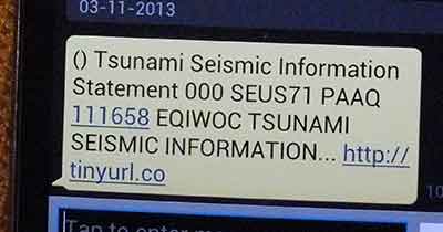
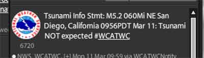
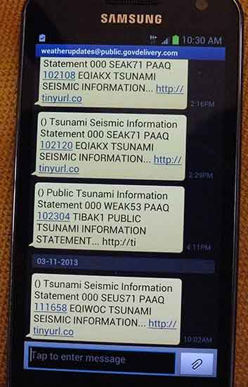
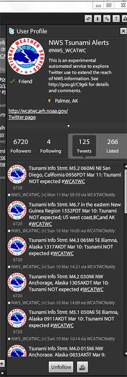


