In a news release this afternoon, Pacific Northwest LNG announced that the company has given a positive, but conditional, Final Investment Decision, to build an LNG facility on the environmentally sensitive Lelu Island at Port Edward. BC.
Pacific NorthWest LNG (PNW LNG) announced today that the required technical and commercial components of the project have been satisfied. Consequently, PNW LNG has resolved to move forward with a positive Final Investment Decision, subject to two conditions.
The Final Investment Decision will be confirmed by the partners of PNW LNG once two outstanding foundational conditions have been resolved. The first condition is approval of the Project Development Agreement by the Legislative Assembly of British Columbia, and the second is a positive regulatory decision on Pacific NorthWest LNG’s environmental assessment by the Government of Canada.
“In parallel with work to support the Final Investment Decision, Pacific NorthWest LNG will continue constructive engagement with area First Nations, local communities, stakeholders and regulators,” said Michael Culbert, President of Pacific NorthWest LNG. “The integrated project is poised to create thousands of construction and operational careers in the midst of the current energy sector slowdown.”
Progress Energy Canada and the North Montney Joint Venture partners will continue to invest in its North Montney natural gas resources. The investment to date has proved and probable natural gas reserves of over 20 trillion cubic feet (tcf) with $2 billion-plus invested annually, representing approximately 4,000 sustainable jobs in northeast British Columbia.
“A Final Investment Decision is a crucial step to ensure that the project stays on track to service contracted LNG customers,” Culbert continued. “Pacific NorthWest LNG is poised to make a substantial investment that will benefit Canada for generations to come.”
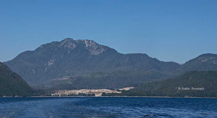
Lelu Island, the flat area in the left of the image, across from the harbour at Port Edward is the potential site of the Petronas Pacific Northwest LNG project. (Robin Rowland/Northwest Coast Energy News)
Although Pacific Northwest LNG is first off the mark with a positive, if conditional, Final Investment Decision, putting a shovel in the ground is not guaranteed. Of all the proposed liquified natural gas projects for northwestern BC, the location on Lelu Island, right at the mouth of the Skeena River, is probably the most environmentally sensitive. Even if the Canadian Environmental Assessment Agency does give its approval, probably with a long list of conditions, it is highly likely the decision will be challenged in court by First Nations and environmental groups.
The environmental process was put on hold in early June after the agency asked Pacific Northwest to provide more information about building the terminal. The island sits near Flora Bank, where young salmon shelter in eel grass after coming down the Skeena, taking time to grow before venturing out into the Pacific. Flora Bank has been called the “nursery” for one of the world’s most important salmon runs.
The fact that Pacific Northwest LNG has to supply more studies means that any final environmental assessment decision will come after October’s federal election.
After initial proposals to dredge the area where met with loud and sustained opposition, Pacific Northwest proposed a suspension bridge and trestle which means the LNG tankers would tie up well off the island in Chatham Sound.
Lelu Island is on the traditional territory of the Lax Kw’alaams First Nation. Members of the First Nation recently voted overwhelmingly against accepting a billion dollars over the life of the project from Pacific Northwest.
Pacific NorthWest LNG filed a report, prepared by engineering and environmental company Stantec Inc., that said there would little or no environmental impact impact from building the $11.4-billion LNG terminal. Stantec’s report, however, is unlikely to reassure many people in the northwest because of Stantec’s close to ties to the energy industry. Stantec did major studies for the controversial Enbridge Northern Gateway project, studies that were challenged by other environmental studies opposing that pipeline project.
Petronas holds 62-per-cent of Pacific NorthWest LNG.
Partners are China’s Sinopec, which holds 10 per cent, Indian Oil Corp. Ltd. which holds 10 per cent, Japan Petroleum Exploration, 10 per cent, China Huadian Corp., 5 per cent and Petroleum Brunei, 3 per cent.
As well some First Nations and environmental groups in the northwest of British Columbia, in the northeast, Blueberry River First Nations who live in the North Montey natural gas region have said they are worried about increased drilling in their traditional territory are concerned about increased drilling by Progress Energy for natural gas within their traditional territory.
The Blueberry River group says it plans request judicial review of the B.C. Natural Gas Development Ministry’s decision to sign the 23-year royalty agreement for the region.
Chevron, the lead corporation in the Kitimat LNG project announced on January 23 that the Moricetown Indian Band had agreed to join the First Nations Limited Partnership, in effect, approving the Pacific Trail Pipeline that would take natural gas to the project in Kitimat.
Here is the news release from all parties involved.
Vancouver, British Columbia, January 23, 2015 – The First Nations Limited Partnership (FNLP) today announced that Moricetown Indian Band (Moricetown) has joined the FNLP. The FNLP is a commercial partnership that, with the addition of Moricetown, now includes all of the 16 First Nations whose traditional territory is located along the proposed 480 kilometre Pacific Trail Pipeline (PTP) route from Summit Lake to Kitimat, B.C.
“The decision of the Moricetown First Nation Band Council to join the First Nations Limited Partnership is one that we warmly welcome,” said the Honourable Bob Rae, Chairman of FNLP.
“It means all 16 First Nations along the proposed Pacific Trail Pipeline route are partners in a unique approach that combines environmental stewardship, extensive job, procurement, and other economic benefits, and direct financial transfers on a regular basis to each First Nations community.”
The FNLP is without precedent in the Canadian energy industry and the Pacific Trail Pipeline is the only proposed natural gas pipeline for a liquefied natural gas (LNG) facility in B.C. with such a benefits agreement. The proposed PTP and Kitimat LNG Facility projects are owned by Chevron and Apache through a 50/50 joint venture and are operated by Chevron.
“This agreement is unparalleled in balancing strong economic growth measures with preserving our cultural heritage and the environment. There is, quite simply, no other deal that comes close to what we’ve been able to achieve in this partnership,” said Chief Dan George of Ts’il Kaz Koh (Burns Lake).
The commercial partnership ensures that FNLP Nations receive immediate and long-term benefits from the PTP project. These include up to $550 million in direct financial benefits over the life of the PTP project, including a recent enhanced benefit of $10 million a year operating life of the PTP project from the Province of British Columbia. The FNLP Nations also receive substantial economic development, skills training, employment and contracting benefits from PTP under the terms of the agreement.
“Chevron Canada wishes to commend all parties for creating a partnership between industry and First Nations based on mutual respect, trust and economic self-determination. We welcome Moricetown as the 16th member of the FNLP, and look forward to building the Pacific Trail Pipeline with First Nations in a manner that places the highest priority on protecting people and the environment,” said Jeff Lehrmann, President, Chevron Canada Limited.
Measures that reflect environmental protection, vitality of traditional cultural values, protection of aboriginal rights and title, economic self-determination and a sustainable future for First Nations are also part of the FNLP agreement. Members of the FNLP have already received significant benefits to date from the agreement, including $17 million in financial payments.
“We have already seen over 1,600 First Nations members receive skills training through the PTP Aboriginal Skills to Employment Partnership, better known as PTP ASEP. Over 900 of these trainees have found jobs,” said Chief Karen Ogen of the Wet’suwet’en First Nation.
First Nations employment currently accounts for 54 per cent of all early works construction workforce hours to date on the Pacific Trail Pipeline. To date, FNLP members have also been awarded over $245 million in PTP construction contracts, and over 65 per cent of construction contract expenditures have been made to member First Nation businesses.
The agreement also facilitates joint ventures between FNLP and companies engaged in the PTP Project. As such, the FNLP Nations not only have a clear financial interest in the pipeline construction but, just as importantly, also have a strong voice in ensuring the preservation of environmental and cultural integrity.
“The FNLP is an innovative model for how industry and First Nations can cooperate effectively with respect to major economic development projects,” said the Honourable Bob Rae.
About First Nations (PTP) Group Limited Partnership (FNLP)
The First Nations (PTP) Group Limited Partnership (FNLP) is a limited partnership of 16 First Nations whose traditional territories are located along the transportation corridor between Summit Lake and Kitimat, British Columbia.
FNLP was formed to secure significant, reliable and long-term economic benefits for its limited partners from the proposed PTP Project.
FNLP member Nations are:
* Haisla Nation
* Kitselas First Nation
* Lax Kw’alaams Band
* Lheidleh T’eneh First Nation
* McLeod Lake Indian Band
* Metlakatla First Nation
* Moricetown Indian Band
* Nadleh Whut’en First Nation
* Nak’azdli Band
* Nee Tahi Buhn Indian Band
* Saik’uz First Nation
* Skin Tyee First Nation
* Stellat’en First Nation
* Ts’il Kaz Koh First Nation (Burns Lake Indian Band)
* West Moberly First Nations
* Wet’suwet’en First Nation
About PTP and the Pacific Trail Pipelines Limited Partnership
The proposed 480-kilometre Pacific Trail Pipeline Project is jointly owned by Chevron Canada Limited (Chevron) and Apache Canada Ltd. (Apache) through the Pacific Trail Pipelines Limited Partnership (PTPLP). The PTP is intended to deliver natural gas from Summit Lake
B.C. to the proposed Kitimat LNG facility on B.C.’s north coast. The Pacific Trail Pipelines Limited Partnership (PTPLP) acquired the project in February 2011 from Pacific Northern Gas.
The fact that the Moricetown Band had held out for so long was seen as one of several factors that was holding up a Final Investment Decision by Chevron and its soon to be new partner, Australia’s Woodside Pretroleum, which is currently finalizing a deal to buy Apache’s stake in the project. Chevron vice chairman, George Kirkland was asked about it during an investor conference call in August, 2014 At the time, Kirkland hinted at the potential problems with the Pacific Trails Pipeline, where there is still a dispute with members of the Wet’suwet’en First Nation. “We’re going to focus on the pipeline and the end of the pipeline corridor. That’s important and we’re putting some money into that to finalize the pipeline routing, get all our clearances and then we’ve got work going on.”
The Unist’ot’en Camp group which opposes energy development in the traditional territory of that House has not yet commented on the announcement. However, earlier Friday at a protest in Winnipeg, Freda Huson, Spokesperson for the Unist’ot’en People and Hereditary Chief Toghestiy of the Likhts´amisyu Clan, issued this statement.
¨The Hereditary Chiefs of the Wet´suwet´en People will stop all attempts from Pipeline Companies, Colonial Governments, and their sell-out employees from bringing Tar Sands Bitumen or Fracked Gas onto our lands. We have ancestral integrity which guides us and will help us ensure that we make the right decisions to protect our lands for all of our unborn generations. We will hold ALL those accountable for attempting to enable destructive agendas to take hold on our sacred lands. We will use our traditional governing systems, the colonial courts, grassroots Indigenous Peoples, and our media savy to make everyone associated with Pipelines, Tar Sands, and Fracking activity from affecting our unceded lands. We are armed with our indomitable spirit and 2 Supreme Court of Canada decisions and will use them against any more aggressors on our unceded lands. Consider this a warning for attempting to trespass on our homelands. We have defended our lands for countless generations and we will stand up like our ancestors have to ensure that we never are viewed as weak in the eyes of our ancestors or children.
The bear totem at the University of Northern British Columbia, one of the backdrops considered by Natural Resources for an announcement by Joe Oliver. (UNBC)
If anyone wanted a snapshot (or for younger folks a selfie) of why the Harper government grounded out at home, never even getting to first base with northwestern British Columbia on Northern Gateway and other resource projects, it can be found in about sixty pages of documents, obtained by Northwest Coast Energy News under the Access to Information Act, documents that outline the planning for former Natural Resources Minister Joe Oliver’s first visit to Terrace in March 2013
The documents reveal the priority for Natural Resources communications staff was mainly finding an appropriate First Nations visual backdrop for Oliver’s speech announcing the appointment of Douglas Eyford as special representative to First Nations, the Harper government’s attempt to smooth relations as it dawned on the government that opposition to Northern Gateway wasn’t just going to disappear.
Despite years of media coverage from both those opposed to and even those who support the Northern Gateway project that highest priority issue was preventing oil spills whether from tankers or pipelines, the Ottawa-based communications planners in Natural Resources Canada were talking about how aboriginal and non-aboriginal communities could respond to oil spills.
For an event that was supposed to engage the First Nations of coastal British Columbia and gain their support for resource projects, all the economic examples are about Alberta First Nations who are working the extraction of bitumen in Alberta, there are no example of how BC First Nations might profit from Northern Gateway (that is if any BC First Nations actually wanted to do so)
When Natural Resources Canada started planning Joe Oliver’s announcement they created what was called a “Message Event Proposal” which even in its title shows how the government and the communications staff think. The message is more important than the event.
Finding a background with a First Nations focus was a high priority for Natural Resources Canada in choosing Northwest Community College in Terrace for an announcement by Minister Joe Oliver on March 19, 2013. (Robin Rowland/Northwest Coast Energy News)
The planning documents from Natural Resources, starting on March 5, 2013, indicate that from the beginning the announcement was being treated as a photo op. Invitations to or participation by “stakeholders” are listed as N/A “not applicable,” which meant that meetings, even private meetings, with representatives of northwestern First Nations and other communities either weren’t considered or the communications staff weren’t informed. (If there were such plans they were not part of the access documents released and as far as Northwest Coast Energy News can find out no meetings took place since Oliver left for Ottawa immediately after the announcement)
The documents show that there were no plans to involve “stakeholders” in Joe Oliver’s announcement.
The Natural Resources communications staff were working on multiple angles in March, as part of what the planning documents call “a suite of events in Vancouver on marine and pipeline safety.”
The first set of those events would eventually take place on March 18, 2013, in Vancouver, and included the announcement, without consulting either Rio Tinto Alcan or the District, that Kitimat’s private port run by Alcan since it was first built would be turned in a federal public port.
That location certainly wasn’t clear at first. The first documents suggested the announcement take place in Vancouver, and then a day later on March 6, the proposed venue, according to the staff, was in either Prince Rupert or Prince George.
According to the internal e-mails, sometime that week what Ottawa bureaucrats call MINO — the minister’s office– decided that the venue should be Terrace. On March 11, e-mails among Natural Resources staff show that the choice had changed to either Terrace or Prince George.
Since the “special representative” whom we now know would be Douglas Eyford, would report directly to Prime Minister Stephen Harper, the political level was involved. MINO took over writing Oliver’s speech and the arrangements were copied to the Privy Council Office, the civil service branch that has overall supervision of the federal bureaucrats and works directly with the Prime Minister. So the speech that the communications branch had drafted for Oliver became “can please turn the one we had done for him into the remarks for the new guy?”
Plan B in Prince George
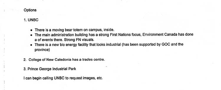
The choice of Terrace left the Natural Resources Ottawa staff hedging their bets, looking for a “potential plan B” in Prince George. The e-mails indicate that Ottawa asked Natural Resources west coast communications officer for a list of suitable locations in Prince George.
The communications officer replied with three locations at the University of Northern British Columbia “a moving bear totem on campus” the main administration building which the e-mail said “ has a strong First Nations focus,” adding “Environment Canada has done…events there. Strong FN visuals.” The third choice was “a new bio energy facility that looks industrial.”
Backups were The College of New Caledonia trade centre and the Prince George industrial park.
Natural Resources Canada also considered the “strong First Nations visuals” at the University of Northern British Columbia administration building. (UNBC)
The University of Northern British Columbia’s bioenergy facility. (UNBC)
E-mails from the staff on Wednesday, March 14 and Thursday, March 15, showed while they were now aware the event would be in Terrace, and probably at Northwest Community College, there was still a lot of uncertainty. “We haven’t been able to contact them to confirm, but as soon as we do, we will let you know the exact details as well as what is required in terms of logistics.”
Remembering that Natural Resources and Transport Canada were also planning the Vancouver event on Monday, March 18, it appears that even as Oliver arrived on the morning of March 19, the minister’s staff both political and bureaucratic were still scrambling.
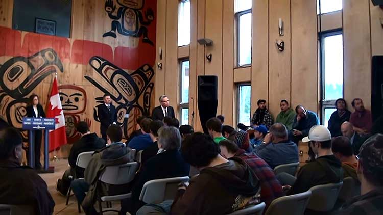
On March 19, the NWCC staff on site were complaining that as soon as the Ottawa delegation saw the standard arrangements for an event at the Waap Galts’ap community long house they ordered the NWCC staff to immediately rearrange the room, so that the podium was in front of one wall with what Oliver’s staff thought was a better First Nations painting. That rearranging was still going on when I arrived to cover the announcement.
Joe Oliver tries out a heavy equipment simulator at Northwest Community College on March 19, 2013, prior to his speech. (Robin Rowland/Northwest Coast Energy News)
Even after the furniture was rearranged, the start was delayed as Oliver and his staff disappeared into an upstairs room for a meeting before the news conference began, and Oliver announced Eyford’s appointment.
During the question and answer session with the media during the news conference, the students that had essentially been brought in as props for the photo op and to help promote Northwest Community College’s industrial training program, began to ask questions.
Joe Oliver listens to a question from a student at the Northwest Community College news conference. (Robin Rowland/Northwest Coast Energy News)
One student asked Oliver if Eyford’s appointment was going to replace “all talks” with First Nations about resource projects. The Natural Resources public relations staff tried to cut off one student, since the national media were waiting on a telephone conference call. To his credit, Oliver did answer the student’s question, saying Eyford’s appointment was not intended to “replace the independent, regulatory review.” He went on to explain the Northern Gateway Joint Review would continue its work and report at the end of 2013.
What was Ottawa thinking? You too, can respond to an oil spill.
If the aim was to engage the First Nations and other residents of northwestern BC, it is clear that the concerns of this region hadn’t reached out Ottawa.
It appears from the planning documents for Joe Oliver’s trip to Terrace, that a main concern of everyone in the northwest, aboriginal and non-aboriginal, opponents and supporters of the Northern Gateway pipeline, preventing oil spills also wasn’t on the government radar, rather it was preparing and responding to oil spills.
Guess who would respond?
As part of the measures to strengthen Canada’s Marine Oil Spill Preparedness and Response Regime, the Government of Canada will strengthen the engagement and involvement of Aboriginal and non-aboriginal communities in preparing for and responding to oil spills.
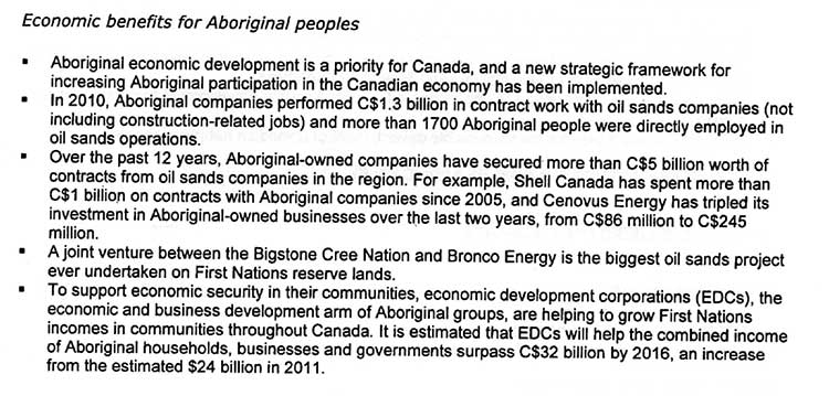
When it comes to a key section on benefits from the Northern Gateway and other resource projects, there is no mention of benefits to British Columbia; rather it appears all the examples of benefits for aboriginal communities come from Alberta, including $1.3 billion in contract work for oil sands companies not including construction, for the year 2010, and $5 billion since 2001. The Message Event Proposal also cites a joint venture between the Bigstone Cree and Bronco Energy, “the biggest oil sands project every undertaken on First Nations reserve lands.”
Overall the plan was to “Promote Canada’s commitment to achieving its goals under its plan for Responsible Resource Development, including increased consultations with Aboriginal peoples.”
The “media lines’ issued by Natural Resources also outlined the Harper government’s attitude to the Northern Gateway, noting that Eyford’s appointment was independent of the Northern Gateway Joint Review, and went to indicate that the JRP was “conducting a rigorous, extensive, open, science-based assessment.” It adds that “we will continue to rely on the integrity of this process,” again showing how out of touch Natural Resources was (at least in talking points) since by March 2013, there was growing consensus in the northwest that the JRP had lost its credibility.
The media lines also show that the Harper government believed that “Aboriginal consultations are fully integrated into the review process to ensure meaningful consultation occurs,” a position that most First Nations in British Columbia reject, insisting on meaningful consultations between the Crown and the First Nation.
When Eyford presented his report to the Prime Minister in December, 2013, Eyford called for stronger action to engage First Nations opposed to new oil and gas pipelines.
“It’s never too late to engage and do so in a process of good faith negotiations… “This won’t be an easy process. I hope my report is perceived as providing objective and blunt advice to all the parties engaged in this process.’’
The 53 page report contained dozens of recommendations mainly concerned with a more open and principled dialogue with First Nations.
“The development of West Coast energy infrastructure provides an opportunity to forge partnerships and build relationships. There is a strong interest and real opportunity for Canada and aboriginal Canadians to more effectively collaborate to address their respective interests.’’
Editor’s note: On the port issue, an RTA spokesperson noted that talks with the federal government are continuing. He noted that all the Kitimat port facilities are privately owned, by Rio Tinto Alcan or by LNG Canada and there are “multiple stakeholders” involved.
The Wet’suwet’en First Nation will receive approximately $2.8 million from the Province at three different stages in the CGL project: $464,000 upon signing the agreement, $1.16 million when pipeline construction begins, and $1.16 million when the pipeline is in service.
The Wet’suwet’en First Nation will also receive a yet-to-be-determined share of $10 million a year in ongoing benefits per pipeline. The ongoing benefits will be available to First Nations along the natural gas pipeline routes. The B.C. government anticipates signing similar agreements with other First Nations in the near future.
Provincial benefit-sharing offers First Nations resources to partner in economic development, complements industry impact benefit agreements that provide jobs and business opportunities, and is a way for government and First Nations to work together to help grow the LNG industry.
John Rustad, Minister of Aboriginal Relations and Reconciliation says in the release, “Too many First Nation communities have been left out of economic growth in B.C. for far too long. It’s exciting to be able to partner with First Nations like the Wet’suwet’en so they can share in the benefits of a new LNG export industry – stronger economies, good-paying jobs and collectively working to establish environmental legacies made possible by LNG development.”
The release quotes Chief Karen Ogen, Wet’suwet’en First Nation, as saying, “Pipeline benefits agreements are just one vehicle driving our participation in LNG development. While these agreements ensure First Nation communities share in the economic benefits of LNG, we are working collaboratively with the Province and other First Nations to ensure environmental priorities are addressed as well.”
The release also quotes Rich Coleman, Minister of Natural Gas Development as saying, “Our government continues to build strong partnerships with First Nations as LNG development gains momentum. Pipeline benefits agreements like this one pave the way for job creation and economic growth as we work together to further the potential of our natural gas sector.”
The news release says the Wet’suwet’en First Nation is among the 15 First Nations located along the Chevron/Apache Pacific Trail Pipeline route that have already signed agreements that will provide $32 million in benefits to First Nations once construction has started.
British Columbia issued an environmental assessment certificate for the proposed CGL project this fall. In addition to meeting conditions set out in the environmental assessment certificate, the project will now require various federal, provincial and local government permits to proceed.
When the certificate was approved in October, the Office of the Wet’suwet’en, which represents hereditary leadership issued a release saying:
B.C. ‘s approval of Coastal GasLink Pipeline project does not mean the project is a go. The Wet’suwet’en still have the right to determine the use of the land and our future.
Not enough information has been made available through the regulatory process to determine environmental impacts nor infringements to Wet’suwet’en rights title and interest.
Current benefits offered by the province and pipeline companies do not take into account the impacts and infringements to our lands, culture and community well-being, for today and into the future.
One group, the Unist’ot’en Camp, representing one house of the Wet’suwet’en continues to camp out in the bush, and the group says they are determined to block any pipeline construction within their traditional territory.
In its news release, BC says, benefits agreements are separate and different than industry impact benefit agreements. Pipeline benefits agreements are made between the Province and First Nations, exclusive of proponents. Impact benefit agreements are made between proponents and First Nations, exclusive of the Province.
The province of British Columbia has posted a request for bids for an extensive air shed study for Prince Rupert, a study that has much wider scope that the controversial Kitimat air shed study. The maximum cost for the study is set at $500,000.
a study of potential impacts to the environment and human health of air emissions from a range of existing and proposed industrial facilities in the Prince Rupert airshed, further referred to as Prince Rupert Airshed Study (PRAS) in North West British Columbia.
The “effects assessment” should include the “prediction of effects of existing and proposed air emissions of nitrogen dioxide, sulphur dioxide and fine particulate matter (at PM2.5, called dangerous by Wikipedia ) from “an existing BC Hydro gas fired turbine, a proposed oil refinery, and seven proposed LNG export terminals (Pacific Northwest LNG, Prince Rupert LNG, Aurora LNG, Woodside LNG, West Coast Canada LNG, Orca LNG, and Watson Island LNG).”
In addition to “stationary sources” of nitrogen dioxide, sulphur dioxide and particulate matter, “the impact assessment will also include rail and marine transportation sources of these contaminants in the study area.”
Area of the proposed Prince Rupert air shed study. (Environment BC)
The request for proposal goes on to say:
The identified sources will be used for air dispersion modelling to determine how the contaminants in various aggregations (scenarios) will interact with the environment, including surface water, soils, vegetation and humans. Interactions of interest will include:
– water impact mechanisms related to acidification and eutrophication;
– soil impact mechanisms related to acidification and eutrophication; and
– vegetation and human health impact mechanisms related to direct exposure.
Water and soil impact predictions will be based on modelled estimates of critical loads for both media, given existing and predicted conditions in the airshed. Vegetation and human health impact predictions will be based on known thresholds of effects, given modelled existing and predicted conditions (contaminant concentrations) in the airshed.
Although the documents say that the Prince Rupert study will be based on the same parameters at the Kitimat air shed study, the Kitimat study only looked at sulphur dioxide and nitrogen dioxide, and did not include particulate matter.
Environmental groups also criticized the Kitimat air shed study for not including green house gases. The proposed Prince Rupert study also does not include green house gases.
A draft report is due by March 15, for review by the province and affected First Nations and subject to peer review. The District of Kitimat was not asked for comment on the study on that air shed study, even though scholars as far away as Finland were asked to review it. It appears that Prince Rupert itself is also excluded from a chance to review the study. The final report is due on May 15.
The province has issued a permit to Rio Tinto Alcan to increase sulphur dioxide emissions from the Kitimat Modernization Project. The Environmental Appeal Board will hold hearings in January 2015. Elisabeth Stannus and Emily Toews, from Kitimat, have appealed against decision to allow RTA to increase sulphur dioxide emissions.
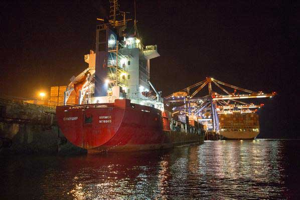
When the Russian container ship Simushir lost power in heavy weather west of Haida Gwaii last Thursday and driven by westerly winds came dangerously close to the rocky coast, Canada and British Columbia had to scramble to get vessels to the ship and try to tow it out of danger to Prince Rupert.
Like all other issues on the west coast, the debate is raging.
The Simushir tied up at the Ridley Island container port. (Prince Rupert Port Authority)
“Peter Lantin, president of the Haida Nation, told the media at the time, “It was luck.” On Tuesday, Lantin issued another statement, saying. ““Unfortunately, I don’t think anyone considers 20 hours a world class response time. The fact of the matter is that the federal government has little interest in protecting the west coast. From all indications their policy is to calculate an oil spill as an acceptable loss, based on a business model, not on the reality that coastal British Columbians live every day.”
It appears that the Simushir operation was lucky. The normal westerly winds that could have driven the ship onto the rocks of Haida Gwaii changed to southeasterly, keeping the Simushir off shore.
The American heavy duty tug Barbara Foss just happened to be available. The Barbara Foss was towing a cargo barge between Prince Rupert and Whittier, Alaska. The barge was left in Prince Rupert and the tug headed out off the coast of Haida Gwaii a trip that took about 48 hours. (There are also heavy duty Smit tugs at Prince Rupert which joined the operation on Hecate Strait to escort the Simushir into port. There are now reports that the Simushir‘s owners chose to hire the Barbara Foss rather than Smit)
The Canadian Coast Guard vessel Gordon Reid tows the Simushir away from the coast of Haida Gwaii. (Maritime Forces Pacific)
It took the first Canadian Coast Guard vessel, the Gordon Reid, about 14 hours to reach the Simushir (according to Coast Guard officials the original report of 20 hours was wrong). The Gordon Reid did manage to get lines on the Simushir and pull the ship away from the coast, only have the tow lines part (break) three times. So the three Coast Guard vessels, two from Canada, the Gordon Reid and the Sir Wilfred Laurier and the US Coast Guard cutter Spar had to wait for the Barbara Foss to arrive.
Jonathan Whitworth, CEO of Seaspan, speaking to Mark Hume of The Globe and Mail, “it was just bad luck” that none of the tugs that regularly work up and down the west coast were available at the time.
Whitworth told The Globe and Mail that there are about 80 boats between Alaska and Vancouver that could have towed the Simushir to safety. He said that the fact there were no tugs in the immediate vicinity as a “fluke.”
“We certainly have large tugs operating in Haida Gwaii on log barges, for example. So it will be a 6,000-horsepower tug that would [typically] be in that area. It just so happened that over the weekend our two biggest tugs which transit that area were down south,” Whitworth told The Globe and Mail.
Whitworth said that permanently stationing tugs at Haida Gwaii would be both be unnecessary and too expensive.“If there had been a tug stationed in Haida Gwaii then it could have responded possibly quicker. But who’s going to pay for that? Surprisingly from a tug owner it’s not going to be [my view] that there should be a tug every 50 metres up the coast.”
Effective response
In a news release, Rear Admiral Dan Abel, commanding the US Coast Guard 17th District, Alaska said.
“The trusted partnership we have with our Canadian counterparts continues to be a vital component to protecting lives at sea and mitigating potential maritime emergencies. We are pleased this case ended with a positive outcome; preparing for the worst case scenario is the first step in an effective prevention and response plan.”
The question now being asked up and down the BC coast has the provincial or federal governments really have an effective prevention and response plan? If the BC coast had trouble handling a container ship in trouble, how is it ever going to handle a Very Large Crude Carrier loaded with diluted bitumen?
According to the US Coast Guard, although the Simushir was adrift off the coast of Haida Gwaii, the incident triggered Alaska’s emergency response plan. “Coast Guard Sector Juneau deployed six members, including the sector’s commander, to Ketchikan to establish the foundation for a unified command and to exercise their sub area contingency plan with state and local partners.”
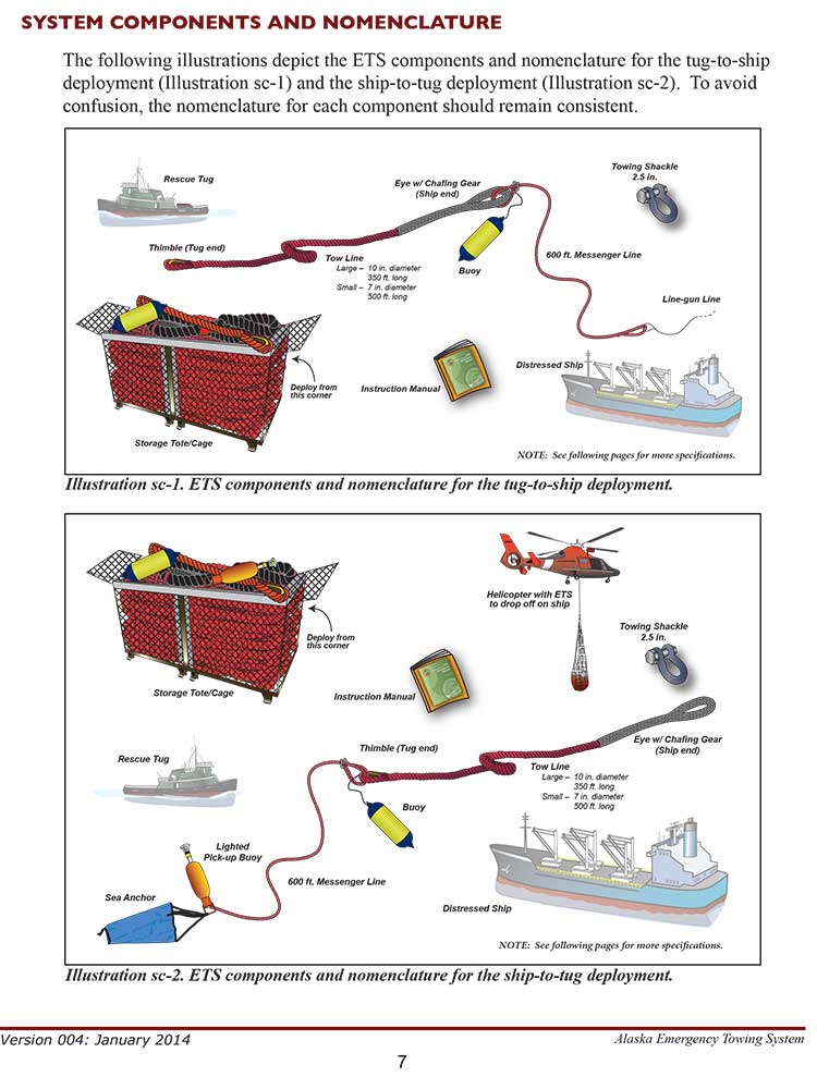
Key to Alaska’s response, is a system ready to go soon after a distress call is received. The Emergency Towing System (ETS) has prepackaged equipment that can be transferred to a disabled vessel either by helicopter or tug, depending on the size and position of the vessel in distress.
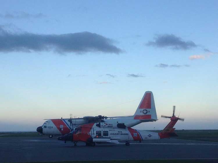
US Coast Guard C-130 Hercules and Skyhawk helicopter on standby at Sandspit airport. The Hercules carried one of Alaska’s Emergency Towing Systems in case it was needed. (US Coast Guard)
The United States Coast Guard deployed two of its Emergency Towing Systems last week to support the Simushir operation, one on a C-130 Hercules dispatched to Sandspit, the second on board the cutter Spar.
While the Alaska ETS systems were not used in the Simushir incident, how Alaska came up with the system is a lesson for British Columbia, for that state-wide program was started by the tiny municipality of Unalaska after a ship quite similar to the Simushir lost power and came within 15 minutes of running aground in Unalaska Bay.
Now just seven years later those Emergency Towing System packages are pre-positioned up and down the Alaska coast, while although Enbridge proposed the Northern Gateway in 2005, here in Canada both the provincial and federal governments make paper promises about a “world class” response system but so far nothing has happened.
Salica Frigo
Salica Frigo photographed in 2006 (Clipper/Wikipedia Commons)
The Salica Frigo incident in March 2007 was similar to the Simushir incident and like the Simushir, there was luck involved.
According to an Associated Press report at the time, quoting 2005 figures, Dutch Harbor and Unalaska was, for the 17th straight year, the United States leading fishing port for seafood landings in poundage. Commercial fishermen offloaded 887.6 million pounds of fish and shellfish in 2005. The value of its catch, $166.1 million, was second to New Bedford, Mass.
About three years earlier, another ship, the 225 metre (738-foot) Selandang Ayu experienced engine problems, shut off its engines, drifted and ran aground Dec. 9, 2004, in Skan Bay on Unalaska Island’s west side.
Six crewmen died when a US Coast Guard helicopter trying to rescue them crashed. The Selandang Ayu broke in two and spilled an estimated 321,000 gallons of fuel oil, contaminating 54 kilometres (34 miles) of coastline. AP reported that at the time of the Salica Frigo incident in 2007, the cleanup for the Selandang Ayu was more than $100 million.
The Salica Frigo was 135 metre (443 foot) Spanish-flagged ship, the same size as the Simushir.
On Thursday, March 8, 2007, the Salica Frigo was partially loaded with seafood and tied up at dock in Captain’s Bay in Dutch Harbor, Alaska Winds were from the north, from 30 to 40 knots gusting to 60 to 70 knots. The winds began to drive the Salica Frigo away from the dock and the local marine pilot, Capt. Stephen Moreno, consulting with the captain, ordered the ship to sea to ride out the winds. “He really didn’t have enough ground tackle to safely anchor,” Moreno told the AP.
The AP report says Moreno guided the Salica Frigo out to sea, plotted a safe course and then the pilot returned to port. At about, 3 am on March 9, the engine failed. It was not until an hour later, at 4 am, according to KIAL News the Salica Frigo’s captain called the marine pilots and the Coast Guard. North winds were blowing the ship back toward the harbor.
“If it had been from the south, he would have blown offshore,” Moreno told the AP.
The powerless ship drifted for more than three and a half hours toward the shore. Two tugboats came to the ship’s aid but could not establish lines to the stricken vessel.
Moreno and Coast Guard officials estimate the Salica Frigo was just 15 minutes from grounding when crew members were able to restart the engine at 6:43 a.m.
Emergency Towing System
Just weeks later, the Mayor of Unalaska, Shirley Marquardt created and convened a “Disabled Vessel Workgroup” that was tasked with developing a “an emergency towing capability for disabled vessels in the Aleutians using locally available tugboats and an emergency towing system.”
For a demonstration project from July 20 to August 1, 2007, Unalaska had put together and purchased a system suitable for vessels up to 50,000 dead weight tons (DWT) while the state, the the Alaska Department of Environmental Conservation was planning to purchase a system capable of towing vessel greater than 50,000 DWT.
The two types of Emergency Towing System packages are pictured in the operations manual. (Alaska Dept. of Environmental Conservation)
In a news release (pdf) at the time of the exercise, the Alaska Department of Environmental Conservation, said
In the last decade, several distressed or stricken vessels in the Aleutian Islands have adversely impacted the community of Unalaska. In a few cases, these incidents were the cause of environmental and economic repercussions.
In each situation, the vessel was a large tramper or cargo type ship, generally carrying fuel in bottom tanks, thus posing a significant pollution risk. Roughly 67% of port calls to Unalaska/Dutch Harbor in 2004 were either container ships or tramper/reefer vessels.
“These accidents can be devastating to Alaska’s environment and communities. Our goal is to enhance the ability of local assets to respond to distressed vessels in need of assistance due to engine failure,rudder failure, or any other failure which compromises the safe navigation of a vessel,” said DEC Commissioner Larry Hartig.
Tugs not always ready
The Emergency Towing System deployed on a tug. (Alaska Dept. of Environmental Conservation)
The other point in the 2007 ADEC news release is a note that tugs are not always equipped for operations such the one involving the Simushir
Generally tug boats (primary responders in this area) have some capability of retrieving vessels but they are not dedicated to this service and therefore the equipment aboard is not representative of equipment needs in this highly specialized situation. The recommended emergency towing system
will enhance local assets with the ability to respond to an emergency with all the proper equipment necessary to retrieve a distressed vessel.
The Unalaska resident tugs Gyrfalcon and James Dunlap are the most consistent local assets in the Unalaska region, but there are many other tugs in the area at any one time and thus this system is intended to be universally deployable.
The demonstration project, a partnership between the town, the state, the Coast Guard and the private sector was successful.
US Coast Guard helicopters deploy the Emergency Towing System (Alaska Dept. of Environmental Conservation)
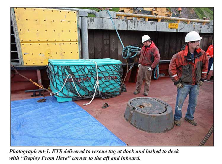
An Emergency Towing System (ETS) is a pre-staged package of equipment that may be deployed in the event a disabled vessel requires assistance in accessing a place of refuge. A manual that instructs responders on the operations of system as well as procedures for deployment accompanies the system. The system is designed to use vessels of opportunity to assist disabled vessels that are in Alaskan waters. It consists of a lightweight high performance towline, a messenger line used in deploying the towline, a lighted buoy, and chafing gear. These components may be configured to deploy to a disabled ship from the stern of a tugboat or airdropped to the ship’s deck via helicopter.
In December 2010, Unalaska’s plan worked, the town’s ETS system was deployed to assist the disable cargo vessel Golden Seas. “This equipment, along with the availability of an appropriate sized towing vessel helped avert a possible grounding.” the ETS website says.
Since 2007, the Alaska Department of Environmental Conservation has purchased and stored 10 inch Emergency Towing Systems at the USCG Air Station in Kodiak and Sitka, the Navy Supervisor of Salvage warehouse at Fort Richardson, and the Emergency Response warehouse in Adak, Alaska.
Map shows where the Emergency Towing System is deployed across Alaska/. (Alaska Dept. of Environmental Conservation)
The Emergency Towing System can be deployed by helicopter or by tug. A helicopter can lower the tote or cage containing the towing gear onto the deck of the distressed ship. If the tote or cage is carried to the scene by a tug the crew the usual procedure is to use a helicopter to deploy the tote/cage to the distressed vessel or the tug crew. Depending on the circumstances, and although it is not part of the regular system, the tug crew can also line-gun projectile across the deck of the distressed ship so the crew can pull a “messenger line” attached to the tow line on board.
And as for Canada, Gail Shea, Minister of Fisheries and Oceans, answering questions in the Commons Monday about the Simushir incident did nothing more than speak off a prepared script, answering two questions from Nathan Cullen, NDP MP for Skeena Bulkley Valley and from Joyce Murray, Liberal MP from Vancouver Quadra, she said future operations were the responsibility of the private sector,
The Russian ship lost power outside Canadian waters in very rough weather. The private sector provides towing service to the marine industry.
We are grateful that the Canadian Coast Guard was able to keep the situation under control in very difficult conditions until the tug arrived from Prince Rupert.
Whitworth told the Globe that with increased tanker traffic whether LNG or bitumen, the number of tugs on the coast will increase, a point also made by supporters of the various projects.
But without a real commitment from the government for marine safety on the west coast, it is clear, even with the prospect of Very Large Crude Carriers with bitumen or Liquefied Natural Gas tankers plying the coast, the Harper Government considers marine safety nothing more than a case of a paper ship upon a paper ocean.
With such indifference, it is likely that local communities up and down the British Columbia coast will have to follow the example of the small town of Unalaska, population 4,376 in 2010 and create the northwest coast’s own emergency system.
There’s a dumb, dumb, really dumb idea that just won’t go away—that Enbridge could solve all its problems if only, if only, it would send the Northern Gateway Pipeline to Prince Rupert.
Enbridge long ago rejected the idea. Before Enbridge updated its website to make Gateway Facts, to make it slick and more attractive, the old website had an FAQ where Enbridge explained why it wasn’t going to Prince Rupert.
Did you consider running the pipeline to Prince Rupert where a major port already exists?
We considered Prince Rupert and Kitimat as possible locations. We carried out a feasibility study that took into account a number of considerations. The study found that the routes to Prince Rupert were too steep to safely run the pipeline, and that Kitimat was the best and safest option available.
Current proposed route for the Northern Gateway pipeline. (Enbridge)
Here in the northwest even the supporters of the Northern Gateway roll their eyes when they hear the old Prince Rupert story come up again and again – and it’s not just because these people support the Kitimat plans for Northern Gateway, it’s because those supporters (not to mention the opponents) have driven along the Skeena from Terrace to Prince Rupert.
There just isn’t any room for a pipeline. It’s a game of centimetres.
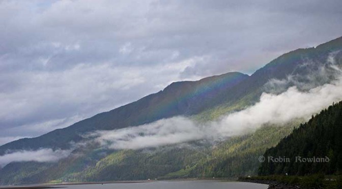
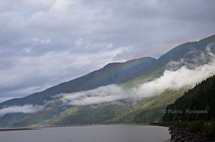
A rainbow hugs the mountains near the Telegraph Point rest area on the Skeena River between Terrace and Prince Rupert, Sept. 29, 2014. Traffic is seen on the narrow corridor between the mountains and the river (Robin Rowland/Northwest Coast Energy News)
Alternatives to Kitimat?
Now the new premier of Alberta, Jim Prentice, who should know better if he’s going to lead that province, is hinting that Kitimat isn’t the only possible solution for the Northern Gateway.
Without specifying Prince Rupert, according to Gary Mason reporting in The Globe and Mail, Prentice was speculating about an alternative to Kitimat.
Asked whether he believes the Gateway terminus should be relocated to Prince Rupert or another destination, Mr. Prentice said, “Everything I’ve heard from the Haisla who live there is they don’t agree with the terminal being in Kitimat.” Is it possible to get First Nations approval if there is no support at the planned terminus site? “It’s pretty tough,” the Premier said.
Prince Rupert has a thriving local fishing industry that employs hundreds of people and is critically important to the local First Nations. He is convinced the community would not be willing to put that at risk.
“Overwhelmingly people in my community are much more comfortable with liquefied natural gas, with wood pellets, with coal, than any oil product,” he said.
The Prince Rupert Port Authority also rejected the idea
A spokesman for the Prince Rupert Port Authority said Wednesday there is currently no room for Enbridge to build at the port even if it wanted to. “We are fully subscribed,” Michael Gurney said. There are two large vacant lots within the port authority’s jurisdiction, but both are locked by other energy companies, earmarked for LNG projects.
So not only is there no room on the road to Prince Rupert, there is no room in Prince Rupert.
Shovel-ready?
Let’s just consider for a moment that if Prince Rupert was the ideal location for the Northern Gateway terminal (which it is not), what would be needed to get the project going today.
The Northern Gateway Joint Review Panel would have be reconstituted or a new JRP created by the National Energy Board. That’s because the bitumen comes from Bruderheim, Alberta, crossing provincial boundaries and thus it’s in federal jurisdiction.
Even under the fast track rules imposed on the NEB by Stephen Harper’s Conservative government, new environmental and social impact studies would be required, starting from scratch. So add another five years of paperwork before a single shovel goes into the ground.
The pipeline would have to cross the traditional territory of First Nations that, so far, have not been part of the negotiations, mostly the Tsimshian First Nation as well as the Nisga’a First Nation which has a treaty establishing local rule over their territory.
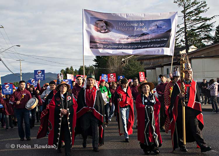
Traditional leaders of the Gitga’at First Nation lead a protest march through the streets of Prince Rupert, February 4, 2012. (Robin Rowland/Northwest Coast Energy News)
In February 2012, the largest anti-Enbridge demonstration outside of the Lower Mainland took place in Prince Rupert, with the elders of the Tsimshian First Nation welcoming the elders and members of the Gitga’at First Nation, at Hartley Bay, which had organized the protest.
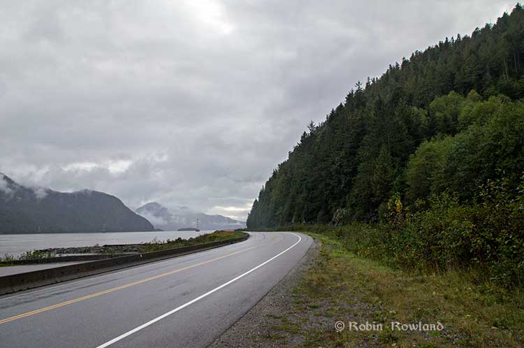
When I say there isn’t room for a pipeline along the Skeena, it also means that there isn’t any room for the pipeline corridor right-of-way. Enbridge, in its submissions to the Joint Review Panel, said it requires a 25 metre wide right of way for the pipeline corridor. (For the record that’s just over 82 feet).
Along that highway, as you will see, there’s barely enough room for the CN mainline and Highway 16 (also known as the Yellowhead Highway) and on a lot of places both the highway and the railway roadbed are built on fill along the side of a cliff.
Albertans’ desperate desire to see the Northern Gateway go to anywhere to what they call “tide water” keeps coming up like the proverbial bad penny. The latest came when Jim Prentice speculated about a new route for the Northern Gateway.
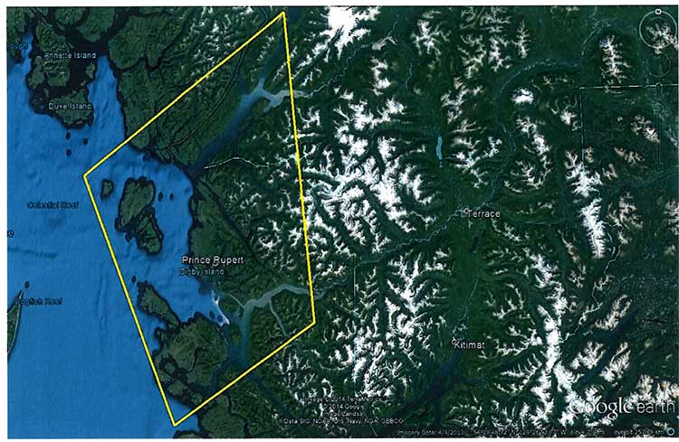
I knew I had an appointment coming up in Prince Rupert on Monday, September 29. So I decided that only way to prove to people sitting in Calgary, Edmonton and Fort McMurray playing with Google Maps that the pipeline to Prince Rupert was a really dumb idea was to shoot photographs to show just why the Northern Gateway will never go to Prince Rupert—at least along the Skeena.
As you drive out of Terrace, you pass two large swing gates (also called by some “Checkpoint Charlie” gates after the Cold War era crossing in Berlin.) At the first rest stop west of Terrace, there are another set of gates at the Exstew. There’s a third set of gates just outside Prince Rupert.
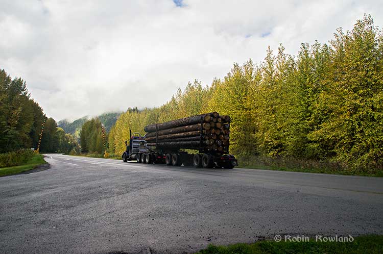
A logging truck passes the avalanche gates at Exstew on Highway 16, Sept. 29, 2014. (Robin Rowland)
The swing gates are avalanche gates and, in the winter, Highway 16 can be shut down if an avalanche closes the highway or the danger from avalanche is too great to allow motorists to proceed. When you drive the highway from Terrace to Prince Rupert in the winter (the signs were covered up when I drove Monday) you are warned “Avalanche danger Next 13 kilometres. No stopping.”
The Exstew avalanche gates, (Robin Rowland/Northwest Coast Energy News)
The drive along the Skeena from just west of Exchamsiks River Provincial Park all the way to Tyee where the highway turns inland to reach northwest to Prince Rupert on Kaien Island is one of the most spectacular drives on this planet. The highway snakes along a narrow strip of land with steep mountain cliffs on one side and the vast river on the other.
The problem is that apart from locals and tourists, none of the “experts” whether journalist, think tanker, bureaucrat or politician have, apparently ever driven from Prince Rupert to Terrace.
When both Opposition Leader Tom Mulcair and Liberal Leader Justin Trudeau were in the northwest earlier this summer to “engage” with the local people, apart from short boat trips down Douglas Channel, they flew everywhere. Scheduling you know. Stephen Harper has never visited northwest BC and probably never intends to. His cabinet members fly in for photo ops and then are on the next plane out of town.
Of all the visiting journalists who have come to the northwest only a couple have bothered to drive around the region. Most fly-in fly-out. These days, most often budget-strapped reporters never leave their offices, interviewing the same usual suspects by phone on every story.
On Monday, I took most of the photographs on my way back from Prince Rupert to Terrace after my appointment, so the sequence is from west to east. There are also very few places along the river where you can safely stop. There are concrete barricades on both sides of the highway to prevent vehicles either going into the river or onto the narrow CN right-of-way.
There are, however, two rest stops and a number of small turnoffs on the highway, the turnoffs mainly intended for use by BC Highways, but which are also used by tourists, fishers and photographers.
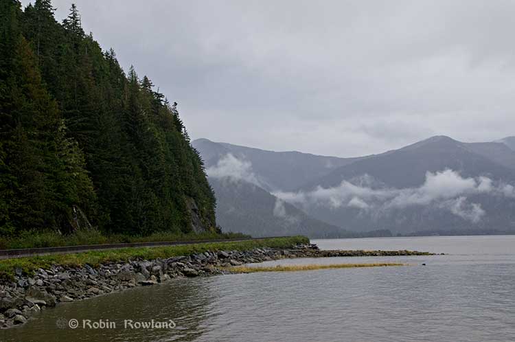
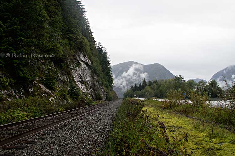
The first image was taken at one of those highway turnoffs just east of Aberdeen Creek. This is what the highway and rail corridor are like all along the Skeena, the highway, bounded by concrete barricades, the CN rail line and then the towering mountains. Note where the telegraph and telephone lines are—further up the cliffside.
A closer view of the highway and rail corridor just east of Aberdeen Creek.
Here is the view of the Skeena River from the Aberdeen Creek turnoff. You can see to the east, a mountain and the narrow strip of fill land that supports the highway and the rail line.
You see the broad width of the mighty Skeena, the Misty River, as it is called by the Tsimshian First Nation and by everyone else who lives in the northwest and on the right side of the image, the highway and rail corridor built on fill.
Any room for a pipeline?
There’s another turnoff on the other side of the headland east of Aberdeen Creek, looking back the way we came.
The final small turnoff is just by the Kylex River. Again you can see how narrow the highway and rail corridor are.
A few kilometres further along—as I said the highway snakes and curves its way along the riverbank– you come to the Basalt Creek rest area. So this telephoto image shows a logging truck heading west, taken from Basalt Creek, looking back at the highway.
Again you can see both the highway and CN line are built on fill. Is there any room for a pipeline?
Any room for a 25 metre pipeline right-of-way?
Between Basalt Creek and Telegraph Point, a few kilometres to the east, again the highway and rail line hug the narrow strip between the river and mountains.
This shot, taken from Telegraph Point, in October 2013, shows a CN intermodal container train heading to Prince Rupert. The container trains and the coal trains usually have between 150 and 180 cars. If a winter avalanche took out a train, there would be environmental damage, but that damage would be insignificant from coal or containers compared to a train of railbit tankers carrying diluted bitumen.
At Telegraph Point, the second of the three rest stops between Prince Rupert and Terrace, again there is just a narrow strip between the mountain, the highway and the river.
Across the highway from the rest stop, you can again see the narrow corridor, the first shot looking west the rail line close to the cliff face, the second, east, with the waterfall, which you don’t see during the rest of the year, fed by the fall monsoon.
Two shots from the same location, Telegraph Point, taken in March, 2013, of a CN locomotive hauling empty coal cars back to the fields around Tumbler Ridge. (No waterfall in March)
Alternative routes
Everyone has assumed that if Northern Gateway changed its route, the most likely choice given the configuration of the pipeline at the moment is to follow the Skeena.
There are alternatives. The Petronas LNG project and its partner TransCanada Pipelines have proposed a more northern cross-country route, which would go north from the Hazeltons, avoiding the Skeena
If Enbridge wanted to try a northern route, similar to the one TransCanada contemplates for Petronas, Northern Gateway would again run into trouble.
It would require reopening or creating a new Joint Review Panel, many more years of environmental and social impact studies of the route, even under Stephen Harper’s fast track system. The TransCanada/Petronas pipeline would also cross the traditional territory of the Gitxsan First Nation and if Enbridge tried that the company would have to deal with the fact that it signed a controversial agreement with Elmer Derrick that was immediately repudiated by most members of the Gitxsan First Nation and eventually dropped by Enbridge.
So why does this idea of a pipeline to Prince Rupert keep coming up?
In most cases, the idea of the pipeline to Prince Rupert is always proposed by Albertans, not from any credible source in British Columbia, or the suggestions come from desk bound analysts in Toronto and Ottawa both in think tanks and in the newsrooms of dying newspapers who have never seen the Skeena River apart from a tiny handful who have looked at Google Street View
(Yes you can Google Street View Highway 16 along the Skeena, I recommend it if you can’t do the drive)
Perhaps the worst example of this failure of both analysis and journalism came in the Edmonton Journal on July 7,2014, when it published a piece by Bob Russell, entitled Opinion: Make Prince Rupert the terminus, which went over the same old inaccurate arguments.
The overland route currently proposed by Enbridge is fraught with environmental issues because it goes over coastal mountains and streams before entering Kitimat’s port. This port will also be the base of perhaps as many as four liquefied natural gas terminals, which will result in the channel always busy with LNG ships outbound and returning from many Asian ports.
There are existing rights of way for the major highway, the Yellowhead, and CN Rail line from Edmonton to the Port of Prince Rupert, so this eliminates the issue of transgressing First Nations lands. The technical issues of narrow passages can be overcome with engineering. In fact, the pipeline can be buried in the roadway at some restricted locations if absolutely necessary, but two different engineers have assured me that for the most part, the right of way should be able to handle the pipeline. A vital factor, of course, is to reduce the impact by eliminating the need for two pipelines.
The clue is how the Edmonton Journal describes Russell;
Bob Russell has an extensive background in planning and was a member of the Edmonton Metro Regional Planning Commission. He has flown the Douglas Channel, visited Kitimat and toured the Port of Prince Rupert.
This is so typical of the Albertan attitude toward northwest British Columbia, people fly in for a couple of days, make a quick observation, and fly out again and present themselves as experts on the region. (Some “experts” on Kitimat, very active on Twitter have apparently never left Calgary).
It obvious that the “two engineers” who assured him “the right-of-way could handle of pipeline” have no idea what they’re talking about. As the photos show there is barely enough room for a highway and a rail line much less a 25 metre wide pipeline corridor.
If the pipeline was to be built as Russell proposed, the only highway between Prince Rupert and the rest of Canada would have to be closed for years, there are no detours. All so a pipeline can be buried under the asphalt not in solid ground, but in the fill on the side of a riverbank in an avalanche zone?
Of course, closing a highway up here won’t inconvenience anyone in Edmonton or Calgary, will it?
Would CN be happy with years of disruption of their lucrative traffic to Prince Rupert with grain and coal outbound to Asia and all those containers coming in to feed Chinese products to the North American market? (you can be sure Walmart wouldn’t be happy about that, not to mention prairie farmers including those from Alberta)
Russell’s statement
There are existing rights of way for the major highway, the Yellowhead, and CN Rail line from Edmonton to the Port of Prince Rupert, so this eliminates the issue of transgressing First Nations lands.
Is also inaccurate.
I was told by First Nations leaders during the Idle No More demonstrations in the winter of 2013, that, a century ago, when the Grand Trunk built the railway along the Skeena , they did just that, built it without consulting the First Nations along the route, sometime digging up native cemeteries and sacred spots.
While apparently CN has worked in recent years to improve relations with the First Nations along the rail line, according to those leaders some issues of right-of-way remain to be resolved.
If there were any plans to build a diluted bitumen pipeline along that route, that would likely mean another court battle adding to those already before the Federal Court, a court battle that would cost Enbridge, CN, the federal government, environmental NGOs and the First Nations more millions in lawyers’ fees.
It’s doubtful if in the long gone (and perhaps mythical) days of “get it right” journalism that the Russell opinion piece would have passed the scrutiny of an old fashioned copy editor and fact checker.
In 2012, the Edmonton Journal (in a story no longer available on their website) also cited former Alberta Premier Peter Lougheed and former Bank of Canada governor David Dodge, as also favouring Prince Rupert.
Dodge, who was in Edmonton Tuesday to deliver a speech on the global economic outlook at MacEwan University, said Enbridge’s proposed Northern Gateway pipeline to Kitimat looks like even more of a long shot.
“I think the project to Kitimat looks, objectively, more risky. So why hasn’t much greater effort gone into looking at Prince Rupert and taking (bitumen) out that way? My guess is, the easiest place to get B.C. to buy into the project would be to go to Rupert.”
Dodge’s views echo those of former Alberta Premier Peter Lougheed, who also favours looking at an alternate pipeline route to Prince Rupert, where ocean-going supertankers can navigate more easily.
Back in 2012, I finished my piece for the Huffington Post by saying:
So why do people insist, despite the evidence, that the Northern Gateway go to Prince Rupert? It’s no longer an pipeline; it’s emotion and ideology. Ideology in that opposition to the Northern Gateway is seen by conservatives as heretical opposition to free enterprise itself. Emotion among those who see promoting the oil patch as an issue of “Alberta pride” and even Canadian patriotism.
For the promoters of the pipeline to Prince Rupert, ignoring the science of geology and the study of geography across all of northwestern B.C. is no different than repeatedly knocking your head against the Paleozoic metamorphic greenstone of the mountain cliffs along the Skeena. It only gives you a headache.
Things haven’t gotten much better in the past two years. In fact they’re getting worse as opposition to pipelines mounts.
It seems that in 2014 the Alberta and the federal government policy in promoting pipelines Northern Gateway, KinderMorgan’s TransMountain, Keystone XL, Line 9 Reversal and Energy East (slick PR and smiling representatives at open houses, politicians at strictly controlled photo ops) is to ignore facts on the ground and to refuse to deal with the concerns of local people from coast to coast.
There could, perhaps, be a more inclusive and truly science-based pipeline planning process that could see pipelines go on optimum routes but that isn’t happening.
The policy for the oil patch and its politician supporters when it comes to pipelines is facts and geology don’t really matter. So they put on ruby slippers, knock their heels together three times and send pipelines down a yellow brick road to an Emerald City (while telling the locals to ignore the man behind the curtain)
The Haisla Nation’s plan for entering the LNG business is based on the idea that “it is anticipated that the Haisla Projects will be developed using a business model based on controlling two components of the value chain: land and pipeline capacity” according to its application to the National Energy Board for a natural gas export licence.
Cedar LNG Development Ltd., owned by the Haisla Nation, filed three requests for export licences with the NEB on August 28, under the names Cedar 1 LNG, Cedar 2 LNG and Cedar 3 LNG. Another name used in the application is the “Haisla Projects.”
The 25-year export licence request is standard in the LNG business; it allows export of natural gas in excess of projected North American requirements. Thus like the NEB hearings for the Kitimat LNG and LNG Canada projects it is not what is called a “facility” licence which is what Enbridge Northern Gateway requested.
The project anticipates six “jetties” that would load LNG into either barges or ships at three points along Douglas Channel, one where the present and financially troubled BC LNG/Douglas Channel Partners project would be.
A second would be beside the BC LNG project, which may refer to the Triton project proposed by Pacific Northern Gas parent company Altagas.
Both are on land now owned by the Haisla Nation in “fee simple” land ownership under Canadian law.
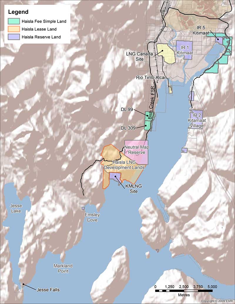
Map from the Haisla application to the NEB showing that the Haisla Projects Region will allow for a total of six LNG jetty sites. One of these, on DL99, is currently ear-marked to be used for a project involving a consortium (BCLNG) One will be situated on the DL309 Haisla fee simple land and the other four jetties are to be situated on the Haisla leased lands that surround the Chevron-led LNG development at Bish Cove. The map also shows that the Haisla own land at Minette Bay.
The other four would be on land surrounding the current Chevron-led Kitimat LNG project along Douglas Channel and in the mountains overlooking Bish Cove which the Haisla have leased.
Haisla Nation Chief Counsellor Ellis Ross at Bish Cove, June 19, 2013. (Robin Rowland/Northwest Coast Energy News)
The move last week and the revelation of the Haisla’s plans for the land are a cumulation of Haisla Nation Chief Counsellor Ellis Ross’s idea of restoring more of the First Nation’s traditional territory by buying or leasing the land using standard Canadian land law and at the same time getting around some of the more restrictive provisions of the Indian Act that apply to reserve land.
Just how the Haisla will go into the pipeline business is not as clear as the First Nation’s acquisition of the land. The application says:
The pipeline capacity required to transport sourced LNG to the Haisla Projects will include a mix of new and existing pipeline and infrastructure. The Haisla are in the advanced stages of negotiating and drafting definitive agreements with the major gas producers and pipeline transmission companies located in the vicinity with respect to securing pipeline capacity. It is expected that the Haisla Projects will rely on the Haisla’s business partners or customers to source gas from their own reserves and the market.
With the Haisla basing their business strategy on land and pipelines, the First Nation’s strategy is looking for flexibility in what is a volatile and uncertain market for LNG.
The application says the Haisla “are currently in advanced stage discussions and negotiations with a number of investors, gas producers, LNG purchasers, pipeline transmission companies, technology providers and shippers. As such, the particular business models have yet to be finalized. However, it is anticipated that between the various Haisla Projects, multiple export arrangements may be utilized.”
As part of the idea of flexibility, the actual LNG infrastructure will be constructed and operated with potential partners. That is why there are three separate applications so that each “application will represent a separate project with independent commercial dealings with investors, gas producers, LNG purchasers, pipeline transmission companies, technology providers and shippers.”
The Haisla say that they are “working with a number of entities to develop business structures and partnerships to provide transaction flexibility, adequate financing, modern technology, local knowledge, and marketing expertise specific to Asian targets. The separate projects will accommodate expected production and demand and will also allow for a number of midlevel organizations to be involved with the various projects as well as traditional major gas producers and LNG purchasers.”
The Haisla are working with the Norwegian Golar LNG which had been involved in the stalled BC LNG project, using a Golar LNG’s vessels and technology, using a new design that is now being built in Singapore by Keppel Shipyard.
Golar LNG uses PRICO LNG process technology developed by Black & Veatch, (Wikipedia entry) “which is reliable, flexible and offers simplified operation and reduced equipment count.”
The filing says the project will “be developed using either barge-based or converted Moss-style FLNG vessels. The terminals will consist of vessel-based liquefaction and processing facilities, vessel-based storage tanks, and facilities to support ship berthing and cargo loading”
The jetties to be used for the Haisla Projects may be either individual FLNG vessels or “double stacked”, meaning that the FLNG vessels are moored side-by-side at a single jetty. The Haisla have conducted various jetty design work and site /evaluation studies with Moffat and Nichol.
The Haisla Projects anticipate that the construction will be in 2017 to 2020, “subject to receiving all necessary permits and approvals” and is expected to continue for a term of up to twenty five years. There is one warning, “The timelines of the Haisla Projects will also depend on the contracts and relationships between the Applicant and its partners.”
The filing goes on to say:
Haisla Nation Council and its Economic Development Committee are committed to furthering economic development for the Haisla. The Haisla’s business philosophy is to advance commercially successful initiatives and to promote environmentally responsible and sustainable development, while minimizing impacts on land and water resources, partnering with First Nations and non-First Nations persons, working with joint venture business partners, and promoting and facilitating long-term development opportunities.
The Haisla Applications will allow the Haisla to be directly involved as participants in Canada’s LNG industry, rather than having only royalty or indirect interests. The Kitimat LNG and LNG Canada projects, and the associated Pacific Trails Pipeline and Coastal Gas Link Pipeline, have increased economic opportunities in the region and the Haisla are very supportive of these projects locating within the traditional territory of the Haisla. The support of the Haisla for these two projects reflects a critical evolution of the Haisla’s economic and social objectives.
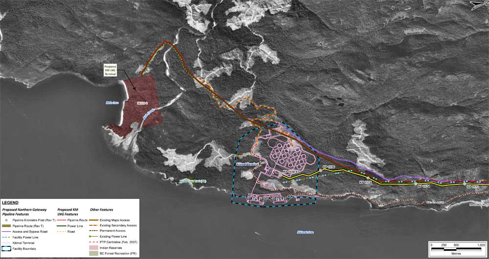
Map from the Haisla Nation application to the NEB showing the proposed LNG developments in relation to Douglas Channel.Map from the Enbridge filing with the Joint Review Panel showing the same area with the proposed Northern Gateway bitumen terminal.
Apache will “completely exit” the Kitimat LNG project, company CEO Steven Farris told investors Thursday as the company reported its second quarter results.
The pull out from Kitimat is part of a plan by Apache to spin off assets that are not part of its “base business” so it can concentrate on its “North American onshore assets.”
“We have said for some time that Canada is part of our North American onshore portfolio,” Farris told analysts in a conference call.
“Certainly we have two businesses up there. [in Canada] We have a business which is a base business with respect to the Duverney Shale and Monteny shale and some of the other things we working on there. We also have the Kitimat-Horn River- Liard. Kitimat -Horn River -Liard is part of our LNG project which we reindicated today that we intend to exit.”
A long view of the Kitimat LNG project at Bish Cove, Sept. 14, 2013. (Robin Rowland/Northwest Coast Energy News)
The Horn River and Liard natural gas fields would have served the LNG project. The divesture could either be as a complete package or sold separately perhaps through the capital markets. The Duverney Shale and Monteny shale plays are considered North American assets, while the Horn RIver Liard plays are considered international because the product from there would be sold in Asia via an LNG terminal.
Chevron, the 50 per cent partner with Apache in Kitimat LNG, said it would have no comment on the Apache move until its own investor conference call Friday morning.
Apache also intends to divest its stake in the Australian Wheatstone LNG project, where Chevron is also a partner.
It was about 18 months ago, Farris said, that Apache changed its focus to “enhancing its North American onshore resource base… We’ve also made it clear that there are no sacred cows as our efforts continue.”
Change in company strategy
Apache CEO Steven Farris. (Apache)
Farris and other executives repeatedly emphasized on the call that the Kitimat and Wheatstone sales were part of an overall change in company strategy.
“I have to honestly say that the complete exit by Apache will not have an impact on Kitimat going forward one way or another,” Farris said.
“Whether we’re in it or not, they will contact with world class reserves and frankly Chevron and Apache are way a head of anybody else in that arena. We’ve always been in a position that we felt we could not be in these LNG projects. I think it’s important that we state that.”
Some other financial analysts on the call seemed a little skeptical about the move, with a couple of questions focused on whether Apache was giving up long term investments.
“In terms of business and priority of capital and time frame of LNG specifically Kitimat it make sense for someone to own it who has a different timeline,” Farris said.
As for the timing of the sale, both Farris and Chief Financial Officer, Alfonso Leon, would not give specifics. “We haven’t decided on a specific timeline, we are working on a number of different opportunities,” Leon said. “Each of them has a different timeline associated with it. So we will make decisions as we reach decision points. Specificaly on the separation work flow…it is not something that will be executed on an imminent basis. Work has been underway but there is still significant work ahead of us.”
The executives would not say how much Apache has spent on Kitimat LNG so far, but it has been estimated at $2 billion just this year.Upgrading the old forest service road to a modern highway capable of supporting heavy truck traffic was estimated to cost $25 million Kitimat LNG officials said late last year.
Fair price
As for the selling price, Farris said that company will hold out for the best deal, saying that Apache has got a “fair price” for international assets that is has already sold, adding that when it comes to Kitimat and Wheatstone. “We won’t sell at prices that don’t make sense,” whether that comes from a package deal with the northeast BC shale assets or through the capital markets.
Overall, Apache Corporation is making money, announcing second-quarter 2014 earnings of $505 million Net cash provided by operating activities totaled approximately $2.3 billion in second-quarter 2014, compared with $2.8 billion in the prior year, with cash from operations before changes in operating assets and liabilities totaling $2.2 billion, compared with $2.6 billion in second-quarter 2013.
In the quarterly report news release, Farris said, “Record-setting performance by our Permian Region continues to drive strong results for the company… Apache’s onshore North American liquids production increased 18 percent on a pro forma basis in the second-quarter 2014 compared with the same period a year ago”
Although some enviromental groups and First Nations are claiming victory in the Apache divestiture, it is clear that those activities had negiligble impact on the decision, which was driven in part by the demands of a New York hedge fund and by the growing uncertainty in the LNG market as Asian countries seek natural gas at much lower North American prices. As the old Godfather movies often said, “It’s not personal, it’s business.”
Apache’s exit, however, does increase the uncertainty in both the short term and long term development of LNG export terminals in northwestern BC, and clearly shows that Premier Christy Clark made a mistake in promising that the provincial economy will boom thanks to LNG.
Both Premier Clark and LNG Minister Rich Coleman were unavailable to the media Thursday. Coleman’s office did send an e-mail tothe media saying, “With 16 LNG proposals involving over 30 partners, we recognize partnerships will change over time, as companies make decisions that make commercial sense for their business. It’s the nature of the business and the energy sector.”
Shell reports
Little noticed in the media attention over Apache, was the fact Royal Dutch Shell also issued its quarterly report early Thursday. Unlike Apache, Shell is still investing in LNG projects around the world, and getting returns from existing LNG projects, while divesting under performing natural gas assets both upstream and downstream. There is no mention of LNG Canada and Kitimat in the report. In a statement issued with the quarterly report Royal Dutch Shell Chief Executive Officer Ben van Beurden commented in part:
I am determined to get a tighter grip on business performance management in the company, and improve thebalance between growth and returns. Our financial performance for the second quarter of 2014 was more robust than year-ago levels but I want tosee stronger, more competitive results right across the company, particularly in Oil Products and NorthAmerica resources plays….
Sharper accountability in the company means that we are targeting our growth investment more effectively,focusing on areas of the business where performance improvement is most needed, and driving asset sales innon-strategic positions….
We see attractive growth opportunities there such as natural gas integration and liquids-rich shales. We are taking firm actions to improve Shell’s capital efficiency by selling selected assets and making tougher project decisions. We have completed some $8 billion of asset sales so far in 2014. This represents good progress towards our targets to focus the portfolio, and to maintain the financial framework in robust health.
The United States says acidification of the oceans means there is an already growing risk to the northwest coast fishery, including crab and salmon, according to studies released by the National Oceanic and Atmospheric Administration.
As more carbon dioxide is released into the atmosphere and absorbed by the oceans, the water is becoming more acidic and that affects many species, especially shellfish, dissolving the shells.
A NOAA study released today of environmental and economic risks to the Alaska fishery says:
Many of Alaska’s nutritionally and economically valuable marine fisheries are located in waters that are already experiencing ocean acidification, and will see more in the near future…. Communities in southeast and southwest Alaska face the highest risk from ocean acidification because they rely heavily on fisheries that are expected to be most affected by ocean acidification…
An earlier NOAA study, released in April, identified a long term threat to the salmon fishery as small ocean snails called pteropods which are a prime food source for pink salmon are already being affected by the acidification of the ocean.
This photograph from NOAA of a pteropod, important in the ocean diet of pink salmon, shows the first evidence of marine snails from the natural environment along the U.S. West Coast with signs that shells are dissolving. (NOAA)
NOAA says:
The term “ocean acidification” describes the process of ocean water becoming more acidic as a result of absorbing nearly a third of the carbon dioxide released into the atmosphere from human sources. This change in ocean chemistry is affecting marine life, particularly the ability of shellfish, corals and small creatures in the early stages of the food chain to build skeletons or shells.
Today’s NOAA study is the first published research by the Synthesis of Arctic Research (SOAR) program, which is supported by an US inter-agency agreement between NOAA’s Office of Oceanic and Atmospheric Research and the Bureau of Ocean Energy Management (BOEM) Alaska Region.
Des Nobles, President of Local #37 Fish [UFAWU-UNIFOR] told Northwest Coast Energy News that the fisheries union and other fisheries groups in Prince Rupert have asked both the Canadian federal and the BC provincial governments for action on ocean acidification. Nobles says so far those requests have been ignored,
Threat to crabs
The studies show that red king crab and tanner crab grow more slowly and don’t survive as well in more acidic waters. Alaska’s coastal waters are particularly vulnerable to ocean acidification because of cold water that can absorb more carbon dioxide and unique ocean circulation patterns which bring naturally acidic deep ocean waters to the surface.
“We went beyond the traditional approach of looking at dollars lost or species impacted; we know these fisheries are lifelines for native communities and what we’ve learned will help them adapt to a changing ocean environment,” said Jeremy Mathis, Ph.D., co-lead author of the study, an oceanographer at NOAA’s Pacific Marine Environmental Laboratory in Seattle, and the director of the University of Alaska Fairbanks School of Fisheries and Ocean Sciences Ocean Acidification Research Center.
As for Dungeness crab, Sarah Cooley, a co-author of the Alaska study, who was with the Woods Hole Oceanographic Institution at the time, told Northwest Coast Energy News, “The studies have not been done for Dungeness crab that have been done for king and tanner crab, that’s something we’re keenly aware of. There’s a big knowledge gap at this point.” She says NOAA may soon be looking at pilot study on Dungeness crab.
A healthy pteropod collected during the U.S. West Coast survey cruise. (NOAA)
Risk to Salmon, Mackerel and Herring
In a 2011-2013 survey, a NOAA-led research team found the first evidence: “that acidity of continental shelf waters off the West Coast is dissolving the shells of tiny free-swimming marine snails, called pteropods, which provide food for pink salmon, mackerel and herring.”
The survey estimated that the percentage of pteropods along the west coast with dissolving shells due to ocean acidification had “doubled in the near shore habitat since the pre-industrial era and is on track to triple by 2050 when coastal waters become 70 percent more corrosive than in the pre-industrial era due to human-caused ocean acidification.”
That study documented the movement of corrosive waters onto the continental shelf from April to September during the upwelling season, when winds bring water rich in carbon dioxide up from depths of about 120 to 180 metres to the surface and onto the continental shelf.
“We haven’t done the extensive amount of studies yet on the young salmon fry,” Cooley said. “I would love to see those studies done. I think there is a real need for that information. Salmon are just so so important for the entire Pacific Northwest and up to Alaska.”
In Prince Rupert, Barb Faggetter, an independent oceanographer whose company Ocean Ecology has consulted for the fisherman’s union and NGOs, who was not part of the study, spoke generally about the threat of acidification to the region.
She is currently studying the impact of the proposed Liquified Natural Gas terminals that could be built at Prince Rupert near the Skeena River estuary. Faggetter said that acidification could affect the species eaten by juvenile salmon. “As young juveniles they eat a lot of zooplankton including crustaceans and shell fish larvae.”
She added, “Any of the shell fish in the fishery, including probably things like sea urchins are all organisms that are susceptible to ocean acidification because of the loss of their capacity to actually incorporate calcium carbonate into their shells.”
Faggetter said her studies have concentrated on potential habitat loss near Prince Rupert as a result of dredging and other activities for liquified natural gas development, She adds that ocean acidification “has been a consideration that climate change will further worsen any potential damage that we’re currently looking at.”
Her studies of the Skeena estuary are concentrating on “rating” areas based on the food supply available to juvenile salmon, as well as predation and what habitat is available and the quality of that habitat to identify areas that “are most important for the juvenile salmon coming out of the Skeena River estuary and which are less important.”
She said that climate change and ocean acidification could impact the Skeena estuary and “probably reduce some of the environments that are currently good because they have a good food supply. If ocean acidification reduces that food supply that will no longer be good habitat for them” [juvenile salmon].
Bongo nets are deployed up to 200 meters deep to catch marine snails (pteropods), which are indicators of the progress of ocean acidification. The pteropod samples were collected during the U.S. West Coast survey cruises in 2011 and 2013. Unlike the US, Canada’s DFO is using models to track what’s happening to pteropods. (NOAA)
The August 2011 NOAA survey of the pteropods was done at sea using “bongo nets” to retrieve the small snails at depths up to 200 metres. The research drew upon a West Coast survey by the NOAA Ocean Acidification Program in that was conducted on board the R/V Wecoma, owned by the National Science Foundation and operated by Oregon State University.
Nina Bednarsek, Ph.D., of NOAA’s Pacific Marine Environmental Laboratory in Seattle, the lead author of the April pteropod paper said, “Our findings are the first evidence that a large fraction of the West Coast pteropod population is being affected by ocean acidification.
“Dissolving coastal pteropod shells point to the need to study how acidification may be affecting the larger marine ecosystem. These near shore waters provide essential habitat to a great diversity of marine species, including many economically important fish that support coastal economies and provide us with food.”
Ecology and economy
Today’s study on the effects of acidification on the Alaska fishery study examined the potential effects on a state where the fishing industry supports over 100,000 jobs and generates more than $5 billion in annual revenue. Fishery-related tourism also brings in $300 million annually to the state.
A map of Alaska shows the economic and ecological risks to parts of the state from ocean acidification. (NOAA)
The study also shows that approximately 120,000 people or roughly 17 percent of Alaskans rely on subsistence fisheries for most, if not all of their dietary protein. The Alaska subsistence fishery is open to all residents of the state who need it, although a majority of those who participate in the subsistence fishery are Alaska’s First Nations. In that way it is somewhat parallel to Canada’s Food, Ceremonial and Social program for First Nations.
“Ocean acidification is not just an ecological problem—it’s an economic problem,” said Steve Colt, Ph.D., co-author of the study and an economist at the University of Alaska Anchorage. “The people of coastal Alaska, who have always looked to the sea for sustenance and prosperity, will be most affected. But all Alaskans need to understand how and where ocean acidification threatens our marine resources so that we can work together to address the challenges and maintain healthy and productive coastal communities.”
The Alaska study recommends that residents and stakeholders in vulnerable regions prepare for environmental challenge and develop response strategies that incorporate community values and needs.
“This research allows planners to think creatively about ways to help coastal communities withstand environmental change,” said Cooley, who is now science outreach manager at Ocean Conservancy, in Washington, D.C. “Adaptations can be tailored to address specific social and environmental weak points that exist in a community.
“This is really the first time that we’ve been able to go under the hood and really look at the factors that make a particular community in a borough or census are less or more vulnerable from changing conditions resulting from acidification. It gives us a lot of power so that we don’t just look at environmental issues but also look at the social story behind that risk.”
As for the southern part of the Alaska panhandle nearest British Columbia, Cooley said, “What we found is that there is a high relative risk compared to some of the other areas of Alaska and that is because the communities there undertake a lot of subsistence fishing, There tend not be a whole lot of commercial harvests in the fisheries there but they are very very important from a subsistence stand point… And they’re tied to species that we expect to be on the front line of acidification, many of the clam species that are harvested in that area and some of the crab species.”
Long term effects
Libby Jewett, Director of the NOAA Ocean Acidification Program and author of the pteropod study said, “Acidification of our oceans may impact marine ecosystems in a way that threatens the sustainability of the marine resources we depend on.
“Research on the progression and impacts of ocean acidification is vital to understanding the consequences of our burning of fossil fuels.”
“Acidification is happening now,” Cooley said. “We have not yet observed major declines in Alaskan harvested species. In Washington and Oregon they have seen widespread oyster mortality from acidification.
“We don’t have the documentation for what’s happening in Alaska right now but there are a lot of studies staring up right now that will just keep an eye out for that sort of thing, Acidification is going to be continuing progressively over the next decades into the future indefinitely until we really curb carbon dioxide emissions. There’s enough momentum in the system that is going to keep acidification advancing for quite some time.
“What we need to be doing as we cut the carbon dioxide, we need to find ways to strength communities that depend on resources and this study allows us to think differently about that and too really look at how we can strengthen those communities.
Faggetter said. “It’s one more blow to an already complex situation here, My study has been working particularly on eel grass on Flora Bank (pdf) which is a very critical habitat, which is going to be impacted by these potential industrial developments and that impact will affect our juvenile salmon and our salmon fishery very dramatically, that could be further worsened by ocean acidification.”
She said that acidification could also be a long term threat to plans in Prince Rupert to establish a geoduck fishery (pronounced gooey-duck).
The popular large 15 to 20 centimetre clam is harvested in Washington State and southern BC, but so far hasn’t been subject to commercial fishing in the north.
NOAA said today’s study shows that by examining all the factors that contribute to risk, more opportunities can be found to prevent harm to human communities at a local level. Decision-makers can address socioeconomic factors that lower the ability of people and communities to adapt to environmental change, such as low incomes, poor nutrition, lack of educational attainment and lack of diverse employment opportunities.
NOAA’s Ocean Acidification Program and the state of Alaska are also developing tools to help industry adapt to increasing acidity.
The new NOAA study is the first published research by the Synthesis of Arctic Research (SOAR) program. which is supported by an inter-agency agreement between NOAA’s Office of Oceanic and Atmospheric Research and the Bureau of Ocean Energy Management (BOEM) Alaska Region.

Pacific NorthWest LNG (PNW LNG) announced today that the required technical and commercial components of the project have been satisfied. Consequently, PNW LNG has resolved to move forward with a positive Final Investment Decision, subject to two conditions.
Progress Energy Canada and the North Montney Joint Venture partners will continue to invest in its North Montney natural gas resources. The investment to date has proved and probable natural gas reserves of over 20 trillion cubic feet (tcf) with $2 billion-plus invested annually, representing approximately 4,000 sustainable jobs in northeast British Columbia.